MATTHEWS c1856 Map Of Upper Canada Ontario Indian Land Agency Divisions Scarce!Luis Porretta Fine Arts4.3(10)See Sold PriceMar 02, 2024
DEVINE c1856 Dr Salters Map Of Lake Huron Ontario Indian Lands etc. No. 7 ScarceLuis Porretta Fine Arts4.3(10)See Sold PriceMar 02, 2024
DUNLEVIE c1856 Map Counties Of Gaspe & Bonaventure Quebec Canada SCARCE! #1Luis Porretta Fine Arts4.3(10)See Sold PriceMar 02, 2024
DUNLEVIE c1856 Map Counties Of Gaspe & Bonaventure Quebec Canada SCARCE! #2Luis Porretta Fine Arts4.3(10)See Sold PriceMar 02, 2024
Map UNITED COUNTIES LEEDS & GRENVILLE by Walling 1861 Rare Canada Map 5ft x 5ftLuis Porretta Fine Arts4.3(10)See Sold PriceMar 02, 2024
Ambroise TARDIEU c1822 Map Venice Napoleon Italian Campaign 17" x 11"Luis Porretta Fine Arts4.3(10)See Sold PriceMar 02, 2024
SDUK: Untitled Map of Western Hemisphere, 1844Map: Untitled. [Western Hemisphere] Publication Date: 1844 Authors: SOCIETY FOR THE DIFFUSION OF USEFUL KNOWLEDGE, WALKER, J. & C. Publisher: SOCIETY FOR THE DIFFUSION OF USEFUL KNOWLEDGE Size: FolioSee Sold Price
SDUK Map of Western Hemisphere, 1844Map: Untitled (Western Hemisphere) Maker: Society for the Diffusion of Useful Knowledge, Walker, J. & C. Date: 1844 Size: Folio, 10.8 inches high x 10.25 inches wide Unusual untitled SDUK map showingSee Sold Price
SDUK: Antique Map of the Western Hemisphere, 1844WESTERN HEMISPHERE' The Republic of Texas is shown as an independent state as it existed between 1836 and 1845; it shows the US-Mexican border prior to the Mexican-American war of 1846-1848 with the pSee Sold Price
Untitled. [Western Hemisphere]1844 Title: Untitled. [Western Hemisphere] Cartographer: WALKER, J. & C. Publisher: SOCIETY FOR THE DIFFUSION OF USEFUL KNOWLEDGE Height: 10.8 Width: 10.25 Unusual untitled SDUK map showing the equatoSee Sold Price
Untitled. [Western Hemisphere]Title/Content of Map: Untitled. [Western Hemisphere] Date Printed: 1844 Cartographer: WALKER, J. & C. Size: 10.8X10.25 Unusual untitled SDUK map showing the equator and continents above and below on pSee Sold Price
WESTERN HEMISPHERE Americas Mexican Texas New Zealand Pacific SDUK 1844 mapTITLE/CONTENT OF MAP: 'WESTERN HEMISPHERE' The Republic of Texas is shown as an independent state as it existed between 1836 and 1845; it shows the US-Mexican border prior to the Mexican-American warSee Sold Price
WESTERN HEMISPHERE. Americas Mexican Texas Pacific New Zealand. SDUK 1844 mapTITLE/CONTENT OF MAP: 'WESTERN HEMISPHERE' The Republic of Texas is shown as an independent state as it existed between 1836 and 1845; it shows the US-Mexican border prior to the Mexican-American warSee Sold Price
WESTERN HEMISPHERE. Americas Mexican Texas Pacific New Zealand. SDUK 1844 mapCAPTION PRINTED BELOW PICTURE: 'WESTERN HEMISPHERE' The map shows the US-Mexican border prior to the Mexican-American war of 1846-1848, with the present US states of California and Texas being shown aSee Sold Price
SDUK: Antique Map of Western Hemisphere, 1845WESTERN HEMISPHERE'. The borders on the map have been drawn to show Texas as being part of Mexico, reflecting the situation prior to the Texas revolution which ended in the Texan declaration of IndepeSee Sold Price
SoldAmerican hemisphere with California an islandHeading: Author: Happel, Eberhard Werner Title: Untitled map of the western hemisphere, with California an island Place Published: Ulm Publisher: Date Published: 1687-[1692] DescriptioSee Sold Price
SDUK: Antique Map of the Western Hemisphere, 1845TITLE/CONTENT OF MAP: 'WESTERN HEMISPHERE' The borders on the map have been drawn to show Texas as being part of Mexico, reflecting the situation prior to the Texas revolution which ended in the TexanSee Sold Price
SDUK: Antique Map of the WESTERN HEMISPHERE, 1845TITLE/CONTENT OF MAP: 'WESTERN HEMISPHERE' The borders on the map have been drawn to show Texas as being part of Mexico, reflecting the situation prior to the Texas revolution which ended in the TexanSee Sold Price
Western Hemisphere Pre Mexican-USA 1845 MapWestern Hemisphere Pre Mexican-American War Pacific USA Canada SDUK, 1845 Map. Title/content of Map: 'western Hemisphere' the Borders on the Map Have Been Drawn to Show Texas as Being Part of Mexico,See Sold Price
Independent Mexico: Days After August 1821 Treaty ofBrue, A. H. (1786-1832). Untitled [Western Hemisphere]. Engraved map. Charles Simonneau, 1821. 36" x 36 ¼" sheet. Very scarce folding wall size map from the Bourbon Restoration period. "Owhyee" ouSee Sold Price
Delahaye: Antique Chart of the Atlantic Ocean, 1750Map: untitled Atlantic chart Cartographer: Delahaye Place & Date: Paris / 1750 Size: 22 1/4" x 19 5/8" Condition: outline color in the Western Hemisphere, the rest in b&w; margins frayed; overall ageSee Sold Price
SoldDelahaye: Atlantic Chart—West Indies to West AfricaReserve Reduced! Title of Map: untitled Atlantic chart Cartographer: Delahaye Place/Date: Paris / 1750 Size: 22 1/4" x 19 5/8" Condition: outline color in the Western Hemisphere, the rest in b&w; margSee Sold Price
SoldLarge Western Hemisphere from ArrowsmithHeading: Author: [Arrowsmith, Aaron] Title: [Untitled. Western Hemisphere only of Map of the World on a Globular Projection] Place Published: [London] Publisher: Date Published: [c.1802-1808See Sold Price
AMERICAS Gnomonic Projection. Texas, Western US is Mexican SDUK 1844 old mapTITLE OF MAP (NOT PRINTED ON THE PAGE):'WORLD ON GNOMONIC PROJECTION, II., America' The national borders on the map have been drawn to show Texas as being part of Mexico, suggesting either that the maSee Sold Price
Untitled. [Western Hemisphere]Title: Untitled. [Western Hemisphere] Publication Date: 1821-09-01 Cartographer: BRUE, A. H. Publisher: CHARLES SIMONNEAU Dimension: X 36.25 Very scarce folding wall size map from the Bourbon RestoratSee Sold Price
SoldSDUK North AmericaSDUK. North America, Canada and the United States; Western Hemisphere, North America sheets 2, 4, 8, 9, 10, 12 & 13,9 engraved map sheets by J. & C. Walker, with original outline or full hand-See Sold Price
CENTRAL ASIA Western Siberia Bukhara Khiva Independent Tartary SDUK 1844 mapTITLE/CONTENT OF MAP: 'WESTERN SIBERIA, Khiva and Bokhara' DATE PRINTED: This map was originally published by The Society for the Diffusion of Useful Knowledge in 1838; this date is printed on the mapSee Sold Price
CENTRAL ASIA Western Siberia Bukhara Khiva Independent Tartary SDUK 1844 mapTITLE/CONTENT OF MAP: 'WESTERN SIBERIA, Khiva and Bokhara' DATE PRINTED: This map was originally published by The Society for the Diffusion of Useful Knowledge in 1838; this date is printed on the mapSee Sold Price
CENTRAL ASIA.Western Siberia, Khiva Bukhara. Independent Tartary SDUK 1844 mapTITLE/CONTENT OF MAP: 'WESTERN SIBERIA, Khiva and Bokhara' DATE PRINTED: This map was originally published by The Society for the Diffusion of Useful Knowledge in 1838; this date is printed on the mapSee Sold Price
CENTRAL ASIA Western Siberia Bukhara Khiva Independent Tartary SDUK 1844 mapTITLE/CONTENT OF MAP: 'WESTERN SIBERIA, Khiva and Bokhara' DATE PRINTED: This map was originally published by The Society for the Diffusion of Useful Knowledge in 1838; this date is printed on the mapSee Sold Price
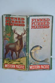
Western Pacific RR Finned Furred Feathered Brochure-1912JM Hobby Supply and Railroad Artifact Auctions4.4(126)See Sold PriceFeb 24, 2024
Great Western RY November 1, 1880 Public TimetableJM Hobby Supply and Railroad Artifact Auctions4.4(126)See Sold PriceFeb 24, 2024
Illinois Central RR July 24, 1906 Western Lines Public TimetableJM Hobby Supply and Railroad Artifact Auctions4.4(126)See Sold PriceFeb 24, 2024
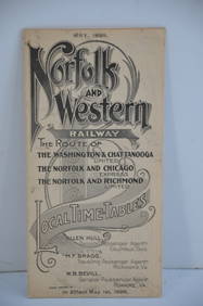
Norfolk and Western RY May 1898 Public TimetableJM Hobby Supply and Railroad Artifact Auctions4.4(126)See Sold PriceFeb 24, 2024
17TH C. WORLD MAP BY NICOLAES VISSCHER (NETHERLANDS, 1618-1709)Thomaston Place Auction Galleries4.4(389)See Sold PriceFeb 24, 2024
19thc Colton Map, Comparitive Size of Lakes & IslandsConnoisseur Auctions3.9(335)See Sold PriceFeb 24, 2024
Pair of Early Railroad Maps - 1874 Delaware, Lackawanna & Western and 1876 Pennsylvania RailroadRail & Road Auctions4.6(165)See Sold PriceMar 07, 2024
Group of Ten Railroad Photographs, Maps, and Prints - New Jersey, Long Island, and New YorkRail & Road Auctions4.6(165)See Sold PriceMar 07, 2024
[ARCTIC]. BOWEN, Emanuel. A New & Accurate Map of the North...Potter & Potter Auctions4.6(544)See Sold PriceMar 07, 2024
[WORLD WAR II – OKINAWA]. Okinawa Shima Western Beaches Top...Potter & Potter Auctions4.6(544)See Sold PriceMar 07, 2024
[MAP]. NICHOLLS, Sutton (1668-1729). An Epitome of Sr. Will...Potter & Potter Auctions4.6(544)See Sold PriceMar 07, 2024
Western, Untitled (Cattle Drive) (two works)Toomey & Co. Auctioneers4.7(391)See Sold PriceFeb 29, 2024
WEST AFRICA Explorers' routes Senegal Ashanti. Mountains of Kong. SDUK 1857 mapJasper524.5(9.8k)See Sold PriceFeb 28, 2024
NORTH AFRICA BARBARY. Parts of Tripoli (Libya) & Egypt. Tribes. SDUK 1844 mapJasper524.5(9.8k)See Sold PriceFeb 28, 2024
NORTH AFRICA BARBARY. Parts of Tripoli (Libya) & Egypt. Tribes. SDUK 1844 mapJasper524.5(9.8k)See Sold PriceFeb 28, 2024
NIGERIA early explorers' routes. Lake Chad. Yariba Houssa Borgou SDUK 1844 mapJasper524.5(9.8k)See Sold PriceFeb 28, 2024
WEST AFRICA showing early explorers' routes & Mountains of Kong. SDUK 1844 mapJasper524.5(9.8k)See Sold PriceFeb 28, 2024


![Untitled. [Western Hemisphere] (1 of 1)](https://p1.liveauctioneers.com/5584/155577/78518556_1_x.jpg?height=282&quality=70&version=1574821323)
![Untitled. [Western Hemisphere] (1 of 1)](https://p1.liveauctioneers.com/5584/120548/61369157_1_x.jpg?height=282&quality=70&version=1524013707)


![Untitled. [Western Hemisphere] (1 of 8)](https://p1.liveauctioneers.com/5584/152686/77105481_1_x.jpg?height=282&quality=70&version=1571789576)


![[ARCTIC]. BOWEN, Emanuel. A New & Accurate Map of the North... (1 of 1)](https://p1.liveauctioneers.com/928/318880/171360917_1_x.jpg?height=282&quality=70&version=1707501302)
![[WORLD WAR II – OKINAWA]. Okinawa Shima Western Beaches Top... (1 of 1)](https://p1.liveauctioneers.com/928/318880/171361141_1_x.jpg?height=282&quality=70&version=1707501302)
![[MAP]. NICHOLLS, Sutton (1668-1729). An Epitome of Sr. Will... (1 of 1)](https://p1.liveauctioneers.com/928/318880/171361281_1_x.jpg?height=282&quality=70&version=1707501302)