ATLAS of ANTIENT GEOGRAPHY by SAMUEL BUTLER 1843John McInnis Auctioneers,LLC4.6(502)See Sold PriceFeb 24, 2024
18TH C. ANTIQUE MAP: FRENCH & INDIAN WAR, FRAMEDThomaston Place Auction Galleries4.4(386)See Sold PriceFeb 24, 2024
Rand McNally Railroad Map Cabinet w/ 21 Railroad MapsRail & Road Auctions4.6(165)See Sold PriceMar 08, 2024
Keith Haring - Ink on New York Map, Best Buddies, Inscribed, Signed, and DatedSapphire Auction Gallery4(67)See Sold PriceMar 02, 2024
LATE 17TH C. FRENCH MAP OF THE NEW WORLD BY ALEXIS-HUBERT JAILLOT (1632-1712)Thomaston Place Auction Galleries4.4(386)See Sold PriceFeb 24, 2024
Central Railroad of New Jersey Map of Sandy Hook Route-ca. 1903JM Hobby Supply and Railroad Artifact Auctions4.4(126)See Sold PriceFeb 24, 2024
Lot of Six Mixed Atlas Box Cars-HO Scale-New in BoxJM Hobby Supply and Railroad Artifact Auctions4.4(126)See Sold PriceFeb 25, 2024
Rand McNally/Santa Fe Railroad Map of Iowa-1912JM Hobby Supply and Railroad Artifact Auctions4.4(126)See Sold PriceFeb 24, 2024
NICOLAES VISSCHER (NETHERLANDS, 1618-1709) MAP OF THE NEW WORLDThomaston Place Auction Galleries4.4(386)See Sold PriceFeb 24, 2024
17TH C. WORLD MAP BY NICOLAES VISSCHER (NETHERLANDS, 1618-1709)Thomaston Place Auction Galleries4.4(386)See Sold PriceFeb 24, 2024
Lot of Six Mixed Atlas Cabooses-HO Scale-New in BoxJM Hobby Supply and Railroad Artifact Auctions4.4(126)See Sold PriceFeb 25, 2024
Mitchell: Map of Mexico & Guatemala, 1854Map: Mexico & Guatemala: Date: 1854 Author: THOMAS, COWPERTHWAIT & CO., MITCHELL, SAMUEL AUGUSTUS Publisher: THOMAS, COWPERTHWAIT & CO. 1854 PHILADELPHIA Size: Quarto – 12.10 H x 15.10 W Inches MainSee Sold Price
Sold[MAP]. MITCHELL. Mexico & Guatemala. 1846[MAP]. MITCHELL, Samuel Augustus (publisher). Mexico & Guatemala: Published by S. Augustus Mitchell, N.E. corner of Market & 7th. Streets Philada. 1846. [inset map at upper right]: Guatemala [See Sold Price
Sold[MAP]. MITCHELL, S. Augustus. Mexico & Guatemala. 1846335. [MAP]. MITCHELL, S. Augustus. Mexico & Guatemala... [lower center above neat line] Entered according to Act of Congress, in the Year 1846 by H.N. Burroughs...36. [inset map and explanation atSee Sold Price
MITCHELL, S. Augustus. Mexico & Guatemala... 1847Atlas Issue, with the Battle Flags in Texas 339. [MAP]. MITCHELL, S[amuel] Augustus. Mexico & Guatemala: PhiladelphiSee Sold Price
MITCHELL, S. Augustus. Mexico & Guatemala... 1846Rare Pocket Map of the Transmississippi West on the Eve of the Mexican-American War 338. [MAP]. MITCHELL, S[amuel] AugustusSee Sold Price
Mexico & Guatemala:Title/Content of Map: Mexico & Guatemala: Date: 1854 Cartographer: MITCHELL, SAMUEL AUGUSTUS Publisher: THOMAS, COWPERTHWAIT & CO. Size: 12.1Height - 15.1Width Main roads shown. Pre-Gadsden Treaty, CoSee Sold Price
S. Augustus Mitchell map of American and Mexico CoS. Augustus Mitchell map of American and Mexico Connecticut (circa 1839) "No. 5 Map of the United States, No. 6 Map of Mexico and Guatemala" hand-colored engraving. (Good condition, trimmed) paper sizSee Sold Price
Mexico & Guatemala:Title: Mexico & Guatemala: Prublication Date: 1854 Cartographer: MITCHELL, SAMUEL AUGUSTUS Publisher: THOMAS, COWPERTHWAIT & CO. Size: 12.1Height - 15.1Width Additional Information: Main roads shown.See Sold Price
SoldMap of U.S., Mexico, & GuatemalaMap of the U.S. and Texas & Mexico and Guatemala by S. Augustus Mitchell Jr. 1840 Size: 17.5 x 11.75 in Please note that this lot has a confidential reserve. When you leave a bid in advance of the aucSee Sold Price
Tanner, H. S. / Mitchell, S. Augustus / Gray, Frank A.Tanner, H. S. / Mitchell, S. Augustus / Gray, Frank A. Mexico & Guatemala / Map of Mexico, Central America.../ Map of Mexico. Pzs: 3.See Sold Price
Tanner, H. S. / Mitchell, S. Augustus / Gray, Frank A.Tanner, H. S. / Mitchell, S. Augustus / Gray, Frank A. Mexico & Guatemala / Map of Mexico, Central America.../ Map of Mexico. Pzs: 3.See Sold Price
Mexico & Guatemala by Mitchell, 1850Original engraving of Mexico & Guatemala by Samuel Augustus Mitchell from Mitchell’s Universal Atlas, 1850. Map features Isthmus of Tehuantepec, Nicaragua, Guatemala & the Valley of Mexico. DimensioSee Sold Price
SoldMitchell, Agustus. Mexico & Guatemala. Philadelphia,Mitchell, Agustus. Mexico & Guatemala. Philadelphia, 1847. Coloured map, 30 x 38 cm. Texas is shown as an independent republic.See Sold Price
SoldMexico & Guatemala: [with insets of isthmuses, GuThomas, Cowperhwait & Co./ Mitchell, Mexico & Guatemala: [with insets of isthmuses, Guatemala, and the Valley of Mexico, guilloche border], lithograph, 1850, 15.5 x 12.5 15.5 x 12.5See Sold Price
Mexico & Guatemala:Title: Mexico & Guatemala: Cartographer: MITCHELL, SAMUEL AUGUSTUS Publisher: THOMAS, COWPERTHWAIT & CO. Height: 12.1 Width: 15.1 Main roads shown. Pre-Gadsden Treaty, Covers much of Texas and the U.SSee Sold Price
SoldMITCHELL'S 1856 NORTH AMERICAN WALL MAPMITCHELL'S 1856 NORTH AMERICAN WALL MAP: First Edition 1856 of the United States, Mexico and West Indies, with inset maps Hawaii (the Sandwich Islands). Map includes the 1854 Gadsen purchase, the 1855See Sold Price
SoldA MAP, MEXICO & GUATEMALA, WITH THE REPUBLIC OF TEXAS, A MAP, MEXICO & GUATEMALA, WITH THE REPUBLIC OF TEXAS, WILLIAM LIZARS, EDINBURGH, 1838. scarce map of Texas, Mexico, Upper California and contiguous parts of the Southeastern United States, naming theSee Sold Price
19th C. English Map Mexico & Guatemala, Gray & Son**First Time At Auction** "Mexico and Guatimala" by Gray & Son, ca. late 19th century. Published by Arch. Full art on & Co. Glasgow. A hand-colored map of Mexico and Guatemala (incorrectly written GuaSee Sold Price
Mexico Guatemala El Salvador Belizes. RevillagigedoTITLE/CONTENT OF MAP: 'Mexico, Guatemala, Salvador and British Honduras' DATE PRINTED: 1904 IMAGE SIZE: Approx 52.5 x 67.0cm, 20.75 x 26.25 inches (Large); Please note that this is a folding map. TYPESee Sold Price
Mexico Guatemala El Salvador Belizes. RevillagigedoTITLE/CONTENT OF MAP: 'Mexico, Guatemala, Salvador and British Honduras' The top image on the right hand side shows the entire map. To view a close up of the map showing the level of printed detail, pSee Sold Price
Sold1835 map of Mexico, Guatemala, W. Indies & U.S.–Diminutive, full-color map of Mexico and the Caribbean as it existed in 1835. Middle of America dominated by just two territories. Modern hand color. Minor foxing. 4.25 x 6. Reserve: $50.00 Shipping:See Sold Price
Mitchell: Map of Mexico, Central America, West IndiesMap: Map of Mexico, Central America, and the West Indies Cartographer: S. A. Mitchell Place & Date: Philadelphia / 1870 Size: 21 1/4" x 13 1/8" The beautifully detailed and colored map of the southernSee Sold Price
Mitchell: Map of Mexico, Central America, CaribbeanTitle/Content of Map: Map of Mexico, Central America, and the West Indies Cartographer: S. A. Mitchell Place & Date: Philadelphia / 1870 Size: 21 1/4" x 13 1/8" Condition: full color; overall age toniSee Sold Price
1849 Mitchell School ATLAS 24 MAPS America Holy Land France Africa Egypt AsiaSchilb Antiquarian Rare Books4.8(421)See Sold PriceMar 31, 2024
Mitchell - Map of the City of Washington (Washington, DC)Trillium Antique Prints & Rare Books4.5(30)See Sold PriceFeb 24, 2024
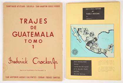
2 color portfolios Natives of Mexico and GuatemalaConcept Art Gallery4.7(508)See Sold PriceMar 06, 2024
Map of Mexico, Central America, New Grenada, Venzuela and the West IndiesJasper524.5(9.8k)See Sold PriceFeb 27, 2024
Northern & Southern Africa. Maghreb. Orange River Sovereignty. HALL 1854 mapJasper524.5(9.8k)See Sold PriceFeb 28, 2024


![[MAP]. MITCHELL. Mexico & Guatemala. 1846 (1 of 5)](https://p1.liveauctioneers.com/514/95447/48676194_1_x.jpg?height=282&quality=70&version=1477936208)
![[MAP]. MITCHELL, S. Augustus. Mexico & Guatemala. 1846 (1 of 3)](https://p1.liveauctioneers.com/514/38482/16500370_1_x.jpg?height=282&quality=70&version=1363615005)