SoldMAP: Johnsons Iowa and Nebraska, c. 1861Historic Maps"Johnson's Iowa and Nebraska" c. 1861, "Johnson's Iowa and Nebraska," published by Johnson & Browning, Choice Extremely Fine. From the Johnson's Family Atlas, measuring 13" x 17," this maSee Sold Price
SoldMAP: Johnsons Iowa and Nebraska, c. 1861Historic Maps"Johnson's Iowa and Nebraska" c. 1861, "Johnson's Iowa and Nebraska," published by Johnson & Browning, Choice Extremely Fine. From the Johnson's Family Atlas,See Sold Price
SoldMAP: Johnsons Iowa and Nebraska, c. 1861Historic Maps“Johnson’s Iowa and Nebraska” c. 1861, “Johnson’s Iowa and Nebraska,” published by Johnson & Browning, Choice Extremely Fine. From the Johnson’sSee Sold Price
SoldMAP: Johnsons Iowa and Nebraska, c. 1861Maps“Johnson’s Iowa and Nebraska” c. 1861, “Johnson’s Iowa and Nebraska,” published by Johnson & Browning, Choice Extremely Fine. From the Johnson’s Family AtSee Sold Price
SoldJohnson's Nebraska and Kansas c.1861Title: Johnson's Nebraska and Kansas Author: Johnson & Browning Description: Lithographed map, hand-colored. 29x36.5 cm. (11½x14¼").Interesting map with Nebraska bordering Canada and the Rockies atSee Sold Price
Three Maps from Johnson & Ward, consisting of:Three Maps from Johnson & Ward, consisting of: "Indiana," 1864, hand colored, H.- 26 1/2 in., W.- 18 in.; together with two copies of Johnson & Ward, "Iowa and Nebraska," 1861 and 1864, hand colored,See Sold Price
Johnson's Nebraska and Kansas c.1861Title: Johnson's Nebraska and Kansas Author: Johnson & Browning Description: Hand-colored lithograph map. 29x36.5 cm. (11½x14¼") plus decorative border.The legend on the map indicates Nebraska extenSee Sold Price
Johnson's Nebraska and Kansas c.1861Title: Johnson's Nebraska and Kansas Author: Johnson & Browning Description: Lithographed map, hand-colored. 29x36.5 cm. (11½x14¼").Interesting map with Nebraska bordering Canada and the Rockies atSee Sold Price
SoldJohnson's Nebraska and Kansas c.1861Title: Johnson's Nebraska and Kansas Author: Johnson & Browning Description: Hand-colored lithograph map. 29x36.5 cm. (11½x14¼") plus decorative border.The legend on the map indicates Nebraska extenSee Sold Price
1861 Johnson Map of Iowa and Eastern Nebraska --Reserve Reduced! Map Title/Content: 1861 Johnson Map of Iowa and Eastern Nebraska -- Johnson's Iowa and Nebraska Cartographer: Johnson & Ward Year / Place: 1861, New York Map Dimension (in.): 12.2 X 1See Sold Price
1861 Iowa & Nebraska. By JohnsonTitle: 1861 Iowa & Nebraska. By Johnson Date/Period: 1861 Materials: Steel engraved. Size: 18x14” 1861. By A. J. Johnson & J. H Colton. From "Johnson's New Illustrated Family Atlas' published in NewSee Sold Price
1861 Iowa & Nebraska. By JohnsonTitle: 1861 Iowa & Nebraska. By Johnson Date/Period: 1861 Materials: Steel engraved. Size: 18x14”. 1861. By A. J. Johnson & J. H Colton. From "Johnson's New Illustrated Family Atlas' published in NeSee Sold Price
1861 Iowa & Nebraska. By JohnsonTitle: 1861 Iowa & Nebraska. By Johnson Date/Period: 1861 Materials: Steel engraved. Size: 18x14”. 1861. By A. J. Johnson & J. H Colton. From "Johnson's New Illustrated Family Atlas' published in NeSee Sold Price
Iowa & Nebraska. By JohnsonTitle: Iowa & Nebraska. By Johnson Date/Period: 1861 Materials: Steel engraved. Size: 18x14”. 1861. By A. J. Johnson & J. H Colton. From "Johnson's New Illustrated Family Atlas' published in New YorSee Sold Price
Iowa & Nebraska. By JohnsonTitle: Iowa & Nebraska. By Johnson Date/Period: 1861 Materials: Steel engraved. Size: 18x14”. 1861. By A. J. Johnson & J. H Colton. From "Johnson's New Illustrated Family Atlas' published in New YorSee Sold Price
Iowa & Nebraska. By JohnsonTitle: Iowa & Nebraska. By Johnson Date/Period: 1861 Materials: Steel engraved. Size: 18x14”. 1861. By A. J. Johnson & J. H Colton. From "Johnson's New Illustrated Family Atlas' published in New YorSee Sold Price
1861. Iowa and eastern Nebraska. By Johnson and BrowningTitle: 1861. Iowa and eastern Nebraska. By Johnson and Browning Date/Period: 1861 Materials: Steel engraved Size: 18x13” 1861, by Johnson and Browning. From ‘New Illustrated Family Atlas,See Sold Price
SoldMAP: Johnsons, Maine, c. 1861Historic Maps"Johnson's Maine" Published Circa 1861 c. 1861, "Johnson's Maine," published by Johnson and Ward, New York, Choice Extremely Fine. From the Johnson's Family Atlas, measuring 16" x 13.5,"See Sold Price
SoldMAP: Johnsons, Maine, c. 1861Historic Maps"Johnson's Maine" Published Circa 1861 c. 1861, "Johnson's Maine," published by Johnson and Ward, New York, Choice Extremely Fine. From the Johnson's Family AtSee Sold Price
SoldMAP: Johnsons, Maine, c. 1861Historic Maps“Johnson’s Maine” Published Circa 1861 c. 1861, “Johnson’s Maine,” published by Johnson and Ward, New York, Choice Extremely Fine. From the Johnson&rsqSee Sold Price
SoldMAP: Johnsons, Maine, c. 1861Historic Maps"Johnson's Maine" Published Circa 1861 c. 1861, "Johnson's Maine," published by Johnson and Ward, New York, Choice Extremely Fine. From the Johnson's Family AtSee Sold Price
SoldMAP: Johnsons, Maine, c. 1861Maps“Johnson’s Maine” Published Circa 1861 c. 1861, “Johnson’s Maine,” published by Johnson and Ward, New York, Choice Extremely Fine. From the Johnson’s FamiSee Sold Price
Rand McNally/Santa Fe Railroad Map of Iowa-1912JM Hobby Supply and Railroad Artifact Auctions4.4(126)See Sold PriceFeb 24, 2024
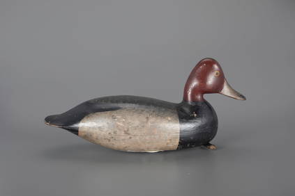
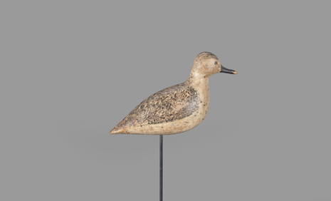
JEB Rig Redhead Drake Decoy by Harry V. Shourds (1861-1920)Copley Fine Art Auctions4.5(40)See Sold PriceFeb 24, 2024
The O'Brien Shourds Winter-Plumage Plover Decoy by Harry V. Shourds (1861-1920)Copley Fine Art Auctions4.5(40)See Sold PriceFeb 24, 2024
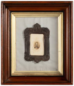
17TH C. WORLD MAP BY NICOLAES VISSCHER (NETHERLANDS, 1618-1709)Thomaston Place Auction Galleries4.4(386)See Sold PriceFeb 24, 2024
LATE 17TH C. FRENCH MAP OF THE NEW WORLD BY ALEXIS-HUBERT JAILLOT (1632-1712)Thomaston Place Auction Galleries4.4(386)See Sold PriceFeb 24, 2024
17TH C. ANTIQUE MAP SIEGE OF LA ROCHELLE, FRANCE, FRAMEDThomaston Place Auction Galleries4.4(386)See Sold PriceFeb 24, 2024
EARLY 18TH C. MAP OF ITALY, FRAMEDThomaston Place Auction Galleries4.4(386)See Sold PriceFeb 24, 2024
LATE 16TH C. MAP OF SCOTLAND BY MERCATOR, FRAMEDThomaston Place Auction Galleries4.4(386)See Sold PriceFeb 24, 2024
17TH C. MAP OF THE BERKSHIRES BY JOHN SPEED, FRAMEDThomaston Place Auction Galleries4.4(386)See Sold PriceFeb 24, 2024
18TH C. ANTIQUE MAP: FRENCH & INDIAN WAR, FRAMEDThomaston Place Auction Galleries4.4(386)See Sold PriceFeb 24, 2024
AN IMPERIAL YELLOW-GROUND GAUZE TWELVE-SYMBOL 'DRAGON' ROBE, JIFU, MOST LIKELY MADE FOR THE EMPRESSGalerie Zacke 4.4(50)See Sold PriceMar 01, 2024
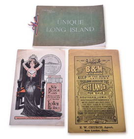
Three Peices of 1800s / Early 1900s Railroad Ephemera Pieces - Boston and Maine, Boston & NorthernRail & Road Auctions4.6(165)See Sold PriceMar 08, 2024
[CIGARETTE CARDS]. A Group of 240 “Seals of the United Stat...Potter & Potter Auctions4.6(539)See Sold PriceMar 07, 2024
Johann Homann Hand-Colored Map Engraving, c. 1730Auctions at Showplace4.5(726)See Sold PriceMar 17, 2024
Willem Blaeu, Etc. 17th C. Antiquarian Maps, 2Auctions at Showplace4.5(726)See Sold PriceMar 17, 2024


![[Ambrotype] Iconic, Published Portrait (1 of 1)](https://p1.liveauctioneers.com/7226/317626/170485470_1_x.jpg?height=282&quality=70&version=1706368022)


![[CIGARETTE CARDS]. A Group of 240 “Seals of the United Stat... (1 of 1)](https://p1.liveauctioneers.com/928/318880/171361506_1_x.jpg?height=282&quality=70&version=1707501302)