ATLAS of ANTIENT GEOGRAPHY by SAMUEL BUTLER 1843John McInnis Auctioneers,LLC4.6(502)See Sold PriceFeb 24, 2024
18TH C. ANTIQUE MAP: FRENCH & INDIAN WAR, FRAMEDThomaston Place Auction Galleries4.4(386)See Sold PriceFeb 24, 2024
Rand McNally Railroad Map Cabinet w/ 21 Railroad MapsRail & Road Auctions4.6(165)See Sold PriceMar 08, 2024
Keith Haring - Ink on New York Map, Best Buddies, Inscribed, Signed, and DatedSapphire Auction Gallery4(67)See Sold PriceMar 02, 2024
LATE 17TH C. FRENCH MAP OF THE NEW WORLD BY ALEXIS-HUBERT JAILLOT (1632-1712)Thomaston Place Auction Galleries4.4(386)See Sold PriceFeb 24, 2024
Central Railroad of New Jersey Map of Sandy Hook Route-ca. 1903JM Hobby Supply and Railroad Artifact Auctions4.4(126)See Sold PriceFeb 24, 2024
Lot of Six Mixed Atlas Box Cars-HO Scale-New in BoxJM Hobby Supply and Railroad Artifact Auctions4.4(126)See Sold PriceFeb 25, 2024
Rand McNally/Santa Fe Railroad Map of Iowa-1912JM Hobby Supply and Railroad Artifact Auctions4.4(126)See Sold PriceFeb 24, 2024
NICOLAES VISSCHER (NETHERLANDS, 1618-1709) MAP OF THE NEW WORLDThomaston Place Auction Galleries4.4(386)See Sold PriceFeb 24, 2024
17TH C. WORLD MAP BY NICOLAES VISSCHER (NETHERLANDS, 1618-1709)Thomaston Place Auction Galleries4.4(386)See Sold PriceFeb 24, 2024
Lot of Six Mixed Atlas Cabooses-HO Scale-New in BoxJM Hobby Supply and Railroad Artifact Auctions4.4(126)See Sold PriceFeb 25, 2024
Sold1836 Sduk Map Of LondonMap: SDUK, C.1836, London, 15.5 x 25.5 in. Please note that this lot has a confidential reserve. When you leave a bid in advance of the auction, submit your maximum. Jasper52 will bid on your behalf aSee Sold Price
Baldwin & Cradock / SDUK: Map of Stockholm, 1836Map: Stockholm Cartographer: Baldwin & Cradock / SDUK Place & Date: London / 1836 Size: 15 3/4" x 13 1/8" Condition: outline color (waterways); overall age toning; left and bottom margins trimmed closSee Sold Price
SoldSDUK: Antique Map of Stockholm, Sweden, 1836Title/Content of Map: Stockholm Cartographer: Baldwin & Cradock / SDUK Place & Date: London / 1836 Size: 15 3/4" x 13 1/8" Condition: outline color (waterways); overall age toning; left and bottom marSee Sold Price
SDUK: Antique Map of Stockholm Sweden, 1836Map: Stockholm Cartographer: Baldwin & Cradock / SDUK Place & Date: London / 1836 Size: 15 3/4" x 13 1/8" Condition: outline color (waterways); overall age toning; left and bottom margins trimmed closSee Sold Price
SDUK North Africa or Barbary IV. Tripoli.“North Africa or Barbary IV. Tripoli.” London: SDUK, 1836. 12 1/4 x 15 1/2. Engraving. Original outline hand-coloring. Very good condition. Please note that this lot has a confidential reserve. WhSee Sold Price
SDUK LiverpoolT. Sartling. “Liverpool.” By the Society for the Diffusion of Useful Knowledge. London: SDUK, 1836. 11 1/2 x 15. Engraving. Original outline hand-coloring. Very good condition. Please note that thSee Sold Price
SDUK North Africa or Barbary I. Marocco“North Africa or Barbary I. Marocco.” London: SDUK, 1836. Ca. 12 x 14 1/2. Engraving. Original outline hand-coloring. Very good condition. Please note that this lot has a confidential reserve. WheSee Sold Price
SDUK LiverpoolT. Sartling. “Liverpool.” By the Society for the Diffusion of Useful Knowledge. London: SDUK, 1836. 11 1/2 x 15. Engraving. Original outline hand-coloring. Very good condition. Please note that thSee Sold Price
SDUK: Antique Plan of Stockholm, 1836Map: Stockholm Cartographer: Baldwin & Cradock / SDUK Place & Date: London / 1836 Size: 15 3/4" x 13 1/8". Condition: outline color (waterways); overall age toning; left and bottom margins trimmed cloSee Sold Price
SoldSDUK: North Africa in 5 sheetsMap Title: North Africa or Barbary I – V Cartographer: Baldwin & Cradock, Society for the Diffusion of Useful Knowledge Place/Date: London / 1836/1852 Size: 15 1/4" x 12 1/2" Condition: b&w; overallSee Sold Price
SDUK: West Africa (Senegal to Cameroon) in 2 sheetsMap Title: West Africa I and II Cartographer: Baldwin & Cradock, Society for the Diffusion of Useful Knowledge Place/Date: London / 1836/1852 Size: 15 1/4" x 12 1/2" (each map) Condition: b&w; overallSee Sold Price
SDUK: West Africa (Senegal to Cameroon) in 2 sheetsTitle: West Africa I and II Cartographer: Baldwin & Cradock, Society for the Diffusion of Useful Knowledge Place/Date: London / 1836/1852Size: 15 1/4" x 12 1/2" (each map) Condition: b&w; overall ageSee Sold Price
SDUK Islands of the Atlantic“Islands in the Atlantic.” London: Baldwin & Gradock, 1836. 15 1/2 x 13. Engraving by J. & C. Walker. Original outline color. Very good condition. Please note that this lot has a confidential reseSee Sold Price
Laurie Engraved Map of The US (Fredonia)Fredonia, or the United States of North America. Richard Holmes Laurie (c. 1755-1836). Engraved Map. London: 1830 (1833). 26 x 38 inches visible, 43 x 52 inches framed. Rare map of the United States,See Sold Price
SoldSketch of the Surprise of GermantownSketch of the Surprise of Germantown... John Hills (fl. 1777-1816) & William Faden (1749-1836). Engraved map. London: Faden, 1784. 21 3/4 x 30 1/2 inches sheet. Hills’ magnificent plan of the BattleSee Sold Price
SDUK: Antique Map of London & Environs, 1847Title/Content of Map: 'THE ENVIRONS OF LONDON' Middlesex Kent Essex Surrey. Coloured. Date Printed: The map is indicated to have been correctd to 1845. This edition of the map was published in 1847 ImSee Sold Price
SDUK Map of Greater London, 1832Map: 1832 SDUK Map of Greater London - The Environs of London Cartographer: SDUK Year / Place: 1832 London Map Dimension: 12.5 x 15.3 in. A highly detailed map of Greater London from Hampton Court toSee Sold Price
SDUK: Antique Map of London & Environs, 1844TITLE/CONTENT OF MAP: 'THE ENVIRONS OF LONDON' DATE PRINTED: This map was originally published by Baldwin & Cradock in 1832; this date is printed on the map. This edition of the map was printed and puSee Sold Price
Sold1832 SDUK Map of Greater London - The Environs ofTitle/Content of Map: 1832 SDUK Map of Greater London - The Environs of London Date: 1832 London Cartographer: SDUKSize: 12.1 x 15.3 in. A highly detailed map of Greater London from Hampton Court to HSee Sold Price
1832 SDUK Map of Greater London - The Environs ofTitle: 1832 SDUK Map of Greater London - The Environs of London Cartographer: SDUK Year / Place: 1832 London Map Dimension (in.): 12.5 x 15.3 in. This is a highly detailed map of Greater London from HSee Sold Price
1832 SDUK Map of Greater London - The Environs ofTitle/Content of Map: 1832 SDUK Map of Greater London - The Environs of London Date Printed: 1832 London Cartographer: SDUK Size: 12.5 x 15.3 in. A highly detailed map of Greater London from Hampton CSee Sold Price
1832 SDUK Map of Greater London - The Environs ofTitle/Content of Map: 1832 SDUK Map of Greater London - The Environs of London Cartographer: SDUK Year/Place: 1832 London Size: 12.5 x 15.3 in. This is a highly detailed map of Greater London from HamSee Sold Price
Antique 1832 SDUK Map of Greater LondonTitle/Content of Map: 1832 SDUK Map of Greater London - The Environs of London Date Printed: 1832 London Cartographer: SDUK Size: 12.5 x 15.3 in. A highly detailed map of Greater London from Hampton CSee Sold Price
1832 SDUK Map of Greater London - The Environs ofTitle/Content of Map: 1832 SDUK Map of Greater London - The Environs of London Date: 1832 London Cartographer: SDUK Size: 12.5 x 15.3 in. This is a highly detailed map of Greater London from Hampton CSee Sold Price
Archaeological Books - The British Museum: The Townley Gallery, Volume I & IITimeLine Auctions Ltd.4.5(183)See Sold PriceMar 06, 2024
[SNAKE CHARMERS]. DOYLE, John (1797 - 1868). Serpent Charme...Potter & Potter Auctions4.6(539)See Sold PriceFeb 24, 2024
WEST AFRICA Explorers' routes Senegal Ashanti. Mountains of Kong. SDUK 1857 mapJasper524.5(9.8k)See Sold PriceFeb 28, 2024
NORTH AFRICA OF BABRBARY V Parts of Tripoli & Egypt. Libya Tribes. SDUK 1846 mapJasper524.5(9.8k)See Sold PriceFeb 28, 2024
WEST AFRICA explorers' routes. Beaufort Gray Park Dochard Caillie. SDUK 1874 mapJasper524.5(9.8k)See Sold PriceFeb 28, 2024
NORTH AFRICA BARBARY. Parts of Tripoli (Libya) & Egypt. Tribes. SDUK 1844 mapJasper524.5(9.8k)See Sold PriceFeb 28, 2024
WEST AFRICA I Explorers' routes Senegal Ashanti Ivory Gold Coast. SDUK 1851 mapJasper524.5(9.8k)See Sold PriceFeb 28, 2024
NORTH AFRICA BARBARY. Parts of Tripoli (Libya) & Egypt. Tribes. SDUK 1844 mapJasper524.5(9.8k)See Sold PriceFeb 28, 2024
NIGERIA explorers' routes. Lander Clapperton Oudney Denham Allen. SDUK 1874 mapJasper524.5(9.8k)See Sold PriceFeb 28, 2024
WEST AFRICA II. NIGERIA. Bight of Benin-Lake Chad. Yariba Houssa. SDUK 1851 mapJasper524.5(9.8k)See Sold PriceFeb 28, 2024
NORTH AFRICA OF BABRBARY V Parts of Tripoli & Egypt. Libya Tribes. SDUK 1851 mapJasper524.5(9.8k)See Sold PriceFeb 28, 2024
NIGERIA early explorers' routes. Lake Chad. Yariba Houssa Borgou SDUK 1844 mapJasper524.5(9.8k)See Sold PriceFeb 28, 2024
NORTH AFRICA BARBARY. Parts of Tripoli (Libya) & Egypt. Tribes. SDUK 1848 mapJasper524.5(9.8k)See Sold PriceFeb 28, 2024
WEST AFRICA showing early explorers' routes & Mountains of Kong. SDUK 1844 mapJasper524.5(9.8k)See Sold PriceFeb 28, 2024
Stanford, Edward 1901 Large Map. Geological Map of the British IslesAlbion Auctions4.6(336)See Sold PriceMar 01, 2024
OLD ILLUSTRATED 1902 CROSS-COVERED LANDS JOURNEY TO CALCUTTA, INDIA, 2 VOLUMESNY Elizabeth 4.3(84)See Sold PriceMar 03, 2024
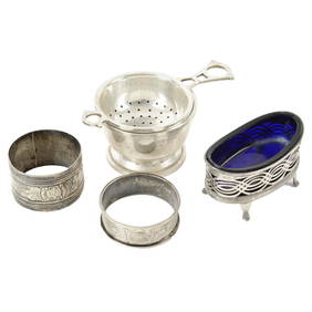
Silver tea strainer, mustard spoon, cased spoons, open salt, napkin rings, etc.Fellows4.3(159)See Sold PriceMar 06, 2024
R. Havell - Black Throated Bunting (1837) - Framed Print #77King's Auctions Inc4.2(121)See Sold PriceDec 29, 2024


![[SNAKE CHARMERS]. DOYLE, John (1797 - 1868). Serpent Charme... (1 of 1)](https://p1.liveauctioneers.com/928/317913/170626070_1_x.jpg?height=282&quality=70&version=1706650066)