ATLAS of ANTIENT GEOGRAPHY by SAMUEL BUTLER 1843John McInnis Auctioneers,LLC4.6(502)See Sold PriceFeb 24, 2024
18TH C. ANTIQUE MAP: FRENCH & INDIAN WAR, FRAMEDThomaston Place Auction Galleries4.4(386)See Sold PriceFeb 24, 2024
Rand McNally Railroad Map Cabinet w/ 21 Railroad MapsRail & Road Auctions4.6(165)See Sold PriceMar 08, 2024
Keith Haring - Ink on New York Map, Best Buddies, Inscribed, Signed, and DatedSapphire Auction Gallery4(67)See Sold PriceMar 02, 2024
LATE 17TH C. FRENCH MAP OF THE NEW WORLD BY ALEXIS-HUBERT JAILLOT (1632-1712)Thomaston Place Auction Galleries4.4(386)See Sold PriceFeb 24, 2024
Central Railroad of New Jersey Map of Sandy Hook Route-ca. 1903JM Hobby Supply and Railroad Artifact Auctions4.4(126)See Sold PriceFeb 24, 2024
Lot of Six Mixed Atlas Box Cars-HO Scale-New in BoxJM Hobby Supply and Railroad Artifact Auctions4.4(126)See Sold PriceFeb 25, 2024
Rand McNally/Santa Fe Railroad Map of Iowa-1912JM Hobby Supply and Railroad Artifact Auctions4.4(126)See Sold PriceFeb 24, 2024
NICOLAES VISSCHER (NETHERLANDS, 1618-1709) MAP OF THE NEW WORLDThomaston Place Auction Galleries4.4(386)See Sold PriceFeb 24, 2024
17TH C. WORLD MAP BY NICOLAES VISSCHER (NETHERLANDS, 1618-1709)Thomaston Place Auction Galleries4.4(386)See Sold PriceFeb 24, 2024
Lot of Six Mixed Atlas Cabooses-HO Scale-New in BoxJM Hobby Supply and Railroad Artifact Auctions4.4(126)See Sold PriceFeb 25, 2024
SoldMap of the Province of New York in 1779Chorographical Map of the Province of New York in 1779. SAUTHIER & PEASE 1849 Size: Approx 96.0 x 72.5cm, 37.75 x 28.5 inches (Large); Please note that this is a folding map. Please note that this lotSee Sold Price
SoldCHOROGRAPHICAL MAP OF THE PROVINCE OF NEW YORK IN NORTHCHOROGRAPHICAL MAP OF THE PROVINCE OF NEW YORK IN NORTH AMERICA, FOR MAJOR GENERAL WILLIAM TYRON, GOVERNOR OF NY, 1779 (REPRINTED BY THE TOWN OF LA GRANGE, SESQUICENTENNIAL COMMITTEE, 1971), MOUNTED OSee Sold Price
MAP -- SAUTHIER, Claude J. A Chorographical Map ofMAP -- SAUTHIER, Claude J. A Chorographical Map of the Province of New-York in North AmericaLondon: William Faden, 1 January 1779. Engraved map, hand-colored, dissected into 36 sections and lSee Sold Price
SoldMontresor, Map of Province of New YorkMONTRESOR, John (1736-1799). A Map of the Province of New York with Part of Pensilvania and New England from an actual survey by Captain Montresor, Engineer, 1775. Engraved map with original color inSee Sold Price
SoldRare - 1768 Holland - Jeffreys Map of New York and NewThe rarest and earliest state of a seminal map. The Provinces of NEW YORK and NEW JERSEY with part of PENSILVANIA, and the Governments of TROIS RIVIERES, and MONTREAL: drawn by Capt. Holland. / A ChorSee Sold Price
SoldNew York Antique Maps (2)Plan of City of New York by Lyne, c. 1900. Map of Provinces of New York and New Jersey by Sauthier, 1878 edition. 26" x 19 1/2".See Sold Price
Sold1776 Map of the Province of New York by Wm FadenLondon, sight 29.5 inches by 24 inchesSee Sold Price
SoldA Map of The Province of New YorkMeasures 23 inches by 29 inches. Property of a Bedford Hills NY Home.See Sold Price
SoldA Map of the Province of New-YorkThis map by Claude Joseph Sauthier (1736-1802) is one of the most celebrated maps of New York and New Jersey of the entire colonial period. It shows all existing towns, counties, and major roads, andSee Sold Price
SoldMap of the Province of New YorkJohn Montresor, Philadelphia with color overall 29" x 37" circa 1775 estimate 1000/1500 Shipping available within the Continental USA (excludes insurance) $30. International shippers are responsible fSee Sold Price
SoldMatthew Albert Lotter hand colored engraved two sheetMatthew Albert Lotter hand colored engraved two sheet map A Map of the Provinces of New-York and New-Jersey with a part of Pennsylvania and the Province of Quebec From the Topographical ObservationSee Sold Price
SoldSAUTHIER, CLAUDE JOSEPH. A Chorographical MapSAUTHIER, CLAUDE JOSEPH. A Chorographical Map of the Province of New-York in North America, Divided into Counties, Manors, Patents and Townships. Large engraved 6-sheet map joined, dissected to form 4See Sold Price
1777 Section Map of New-York New-Jersey byLotterHandcolored map entitled “A Map of the Provinces of New-York and New-Jersey with a Part of Pennsylvania and the Province of Quebec from the Topgraphical Observations of C.J. Sauthier”, printed atSee Sold Price
SoldMap of New York & New JerseyFramed map "A Map of / The Provinces of New York / and New Jersey...AUGSBURG / Engraved and Published by / Matthew Albert Lotter / 1777". Sight 23" x 17", overall 31 1/4" x 25".See Sold Price
Sold1779 Map of New York City. Sauthier. One section.1779 Map of New York City. Sauthier. One section. Sauthier s map of New York summarizes much of the British military mapping done in the years preceding the revolution. Sautier himself typifies the muSee Sold Price
SoldMAP OF NEW YORK, THOMAS KITCHIN, 1756A MAP OF THE EASTERN PART OF THE PROVINCE OF NEW YORK, WITH PART OF NEW JERSEY, showing Pennsylvania, New York state, Long Island, Connecticut and New Hampshire, with Lake OntarioSee Sold Price
SoldHOLLANDl. Map - New York and New Jersey, 1775HOLLAND, Samuel. "The Provinces of New York and New Jersey with part of Pennsylvania, and the Province of Quebec." London: Robt Sayer & John Bennett, 1775. This upper section with three insets: "A ChaSee Sold Price
SoldBritish Revolutionary War Map of the NortheastBritish Revolutionary War Map of the Northeasta copperplate engraving from THE AMERICAN ATLAS by Thomas Jeffreys (London: Sayler and Bennett, 1776), "The Provinces of NEW YORK, and NEW JERSEY; with paSee Sold Price
Sold4 FRAMED MAPS, 3 ANTIQUE & 1 CONTEMPORARYREGNO DI FRANCIA D.1776, 16" X 12"; PROVINCE OF NEW YORK, 1776, COPY, SIGHT 26 ½" X 21";NORTH AFRICA, SIGHT 14 ½" X 19"; ENGRAVING OF ANCIENT TOWNSCAPE 12" X 18 ½"See Sold Price
SoldMap - A Plan of the City of New York. 18th c.Map - A Plan of the City of New York. Marked "Col Rob Lurting Mayor 1728" and "To His Excellency John Montgomerie Esq Capt Gen & Gov in Chief of his Majestis Provinces of New York New Jersey. This PlaSee Sold Price
SoldHolland, Major Samuel51. Holland, Major Samuel.The Provinces of New York, and New Jersey; with part of Pensilvania, and the Province of Quebec. Engraved folding map of the colonial northeast on two sheets. 54 x 21-1/2 incSee Sold Price
SoldGroup of Historical MapsGroup of Historical Maps. Artic Sea, Spitsbergen, 1913 (39" x 27"); Map of the Province of Canada, 1887 (25" x 35"); Map of New York (21" x 28"); Map of Middle British Colonies in America (22" x 30");See Sold Price
Sold1779 NEW AND ACCURATE MAP OF SOUTH CAROLINAA New And Accurate Map Of The Province Of South Carolina In North America. London: Universal Magazine, c. 1779. Good, showing folds, 2 small tears to edges. Narrow margins. The map shows trails and paSee Sold Price
SoldKALM, PETER 22 1/4 x 30 inches.KALM, PETER A New and Accurate Map of Parts of North-America, Comprehending the Provinces of New England, New York, Pensilvania... Warrington, 1770 From the first English edition of Kalm. From SagadahSee Sold Price
1892 Adams and Bowles New Road Map of the State of New YorkJM Hobby Supply and Railroad Artifact Auctions4.4(126)See Sold PriceFeb 24, 2024
Crams Railroad Map of New York-1881JM Hobby Supply and Railroad Artifact Auctions4.4(126)See Sold PriceFeb 24, 2024
Crams Township and Railroad Map of New York-1890JM Hobby Supply and Railroad Artifact Auctions4.4(126)See Sold PriceFeb 24, 2024
Erie Railway Tourist Book/Magazine-1874JM Hobby Supply and Railroad Artifact Auctions4.4(126)See Sold PriceFeb 24, 2024
George Hayward - Map of the City of New York 1854Dane Fine Art Auctions4.4(494)See Sold PriceMar 07, 2024
Vintage County Map Of NY State Plate EngravingThe Benefit Shop Foundation Inc.4.3(2.9k)See Sold PriceFeb 28, 2024
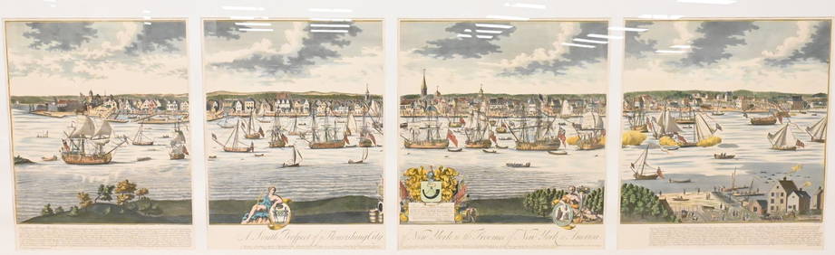
A South Prospect of Ye Flourishing City of New York in the Province of New York, North AmericaNadeau's Auction Gallery4.7(401)See Sold PriceFeb 24, 2024
1855 Map of New York & Erie Railroad and 1917 Trespassing On Railway Property Is A MisdemeanorRail & Road Auctions4.6(165)See Sold PriceMar 07, 2024
Keith Haring - Ink on New York Map, Best Buddies, Inscribed, Signed, and DatedSapphire Auction Gallery4(67)See Sold PriceMar 02, 2024
Keith Haring Artwork Signed on a Shell Oil New York Road Map 18 in. x 24 in.Donny Malone Auctions4.5(1.7k)See Sold PriceMar 04, 2024
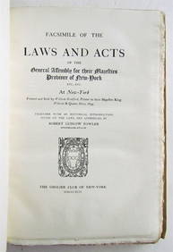
ANTIQUE VELLUM FROM 1894, FACSIMILE OF LAWS AND ACTS OF THE GENERAL ASSEMBLY OF NEW YORKNY Elizabeth 4.3(84)See Sold PriceMar 03, 2024
Black and white map of part of New York City (mostly Manhattan)Proverde Auctions4.3(3)See Sold PriceFeb 28, 2024
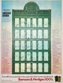
Map Inside Soho - Manhattan - New York Magazine 1974Proverde Auctions4.3(3)See Sold PriceFeb 28, 2024
Laminated Unique Media New York City MapRapid Estate Liquidators and Auction Gallery4.5(1.1k)See Sold PriceFeb 29, 2024