ATLAS of ANTIENT GEOGRAPHY by SAMUEL BUTLER 1843John McInnis Auctioneers,LLC4.6(502)See Sold PriceFeb 24, 2024
18TH C. ANTIQUE MAP: FRENCH & INDIAN WAR, FRAMEDThomaston Place Auction Galleries4.4(386)See Sold PriceFeb 24, 2024
Rand McNally Railroad Map Cabinet w/ 21 Railroad MapsRail & Road Auctions4.6(165)See Sold PriceMar 08, 2024
Keith Haring - Ink on New York Map, Best Buddies, Inscribed, Signed, and DatedSapphire Auction Gallery4(67)See Sold PriceMar 02, 2024
LATE 17TH C. FRENCH MAP OF THE NEW WORLD BY ALEXIS-HUBERT JAILLOT (1632-1712)Thomaston Place Auction Galleries4.4(386)See Sold PriceFeb 24, 2024
Central Railroad of New Jersey Map of Sandy Hook Route-ca. 1903JM Hobby Supply and Railroad Artifact Auctions4.4(126)See Sold PriceFeb 24, 2024
Lot of Six Mixed Atlas Box Cars-HO Scale-New in BoxJM Hobby Supply and Railroad Artifact Auctions4.4(126)See Sold PriceFeb 25, 2024
Rand McNally/Santa Fe Railroad Map of Iowa-1912JM Hobby Supply and Railroad Artifact Auctions4.4(126)See Sold PriceFeb 24, 2024
NICOLAES VISSCHER (NETHERLANDS, 1618-1709) MAP OF THE NEW WORLDThomaston Place Auction Galleries4.4(386)See Sold PriceFeb 24, 2024
17TH C. WORLD MAP BY NICOLAES VISSCHER (NETHERLANDS, 1618-1709)Thomaston Place Auction Galleries4.4(386)See Sold PriceFeb 24, 2024
Lot of Six Mixed Atlas Cabooses-HO Scale-New in BoxJM Hobby Supply and Railroad Artifact Auctions4.4(126)See Sold PriceFeb 25, 2024
Chili, La Plata & Uruguay by Mitchell, 1850Original engraving by Samuel Augustus Mitchell from Mitchell’s Universal Atlas, 1850. Features a vignette of South part of Patagonia. Dimensions: 14 x 16 inchesSee Sold Price
Chili, La Plata & Uruguay (Inset Patagonia) byTitle/Content of Map: Chili, La Plata & Uruguay (Inset Patagonia) by Mitchell, 1850 Date Printed: 1850Cartographer: Samuel Augustus Mitchell Material/Medium: Engraving Size: 14" x 16" Original engraviSee Sold Price
South America Maps-Uraguay, Argentina, Chile, PatagoniaLot of 4. 1) Chili, La Plata, and Uruguay, 1850. Hand colored by Cowperthwait. Approximately 14" x 17." 2) Patagonia, S. Orkney, Falkland Islands, and South Georgia Island by J.H. Colton, New York. 18See Sold Price
SoldSouth America Maps-Uraguay, Argentina, Chile, PatagoniaLot of 4. 1) Chili, La Plata, and Uruguay, 1850. Hand colored by Cowperthwait. Approximately 14" x 17." 2) Patagonia, S. Orkney, Falkland Islands, and South Georgia Island by J.H. Colton, New York. 18See Sold Price
Chili La Plata and Uruguay.Title/Content of Map: Chili La Plata and Uruguay. Date Printed: 1847 Cartographer: MITCHELL, SAMUEL AUGUSTUS Size: 15X12.3 Excellent pastel coloring. Inset of south Patagonia. Margins browned. PleaseSee Sold Price
CHILI, LA PLATA, AND URUGUAY MAPCHILI, LA PLATA, AND URUGUAY MAP. ETCHED AT BOTTOM WITH "ENTERED ACCORDING TO ACT OF CONGRESS IN THE YEAR 1850 BY THOMAS COWPERTWAIT & CO. IN THE CLERKS OFFICE OF THE DISTRICT COURT OF EASTERN DISTRICSee Sold Price
SoldChili La Plata and Uruguay.Reserve Reduced! Title: Chili La Plata and Uruguay. Publication Date: 1846 Cartographer: TANNER, HENRY SCHENCK Publisher: S. AUG. MITCHELL Size: 14.8X12.25 Inset shows Patagonia. From H.S. Tanner's laSee Sold Price
Meyer: Chile, Argentina, Uruguay with Patagonia InsetMap Title: Die Republiken Chili, La Plata und Uruguay 1856 Cartographer: Joseph Meyer / Bibliographischen Instituts Place / Date: Hildburghausen / 1849/1857 Size: 11 5/8" x 14 3/8" Condition: originalSee Sold Price
Meyer: Chile, Argentina, Uruguay with Patagonia InsetMap: Die Republiken Chili, La Plata und Uruguay 1856 Cartographer: Joseph Meyer / Bibliographischen Instituts Place/Date: Hildburghausen / 1849/1857 Size: 11 5/8" x 14 3/8" Condition: original outlineSee Sold Price
Meyer: Antique Map of Chile, Argentina, Uruguay 1849Die Republiken Chili, La Plata und Uruguay 1856 The highly detailed Chili, Argentina (La Plata) and Uruguay map from Meyer's Auswanderungs-Atlas (Emigrant's Atlas). At the lower right is an inset of PSee Sold Price
1850 Map of ChileTitle: 1850 Map of Chile Medium: Ink on Paper Dimensions: 13.5"X17" Map of Chile, showing La Plata and Uruguay dated 1850. Engraved and published by Thomas Cowperthwait in Philadelphia. Inset of PatagSee Sold Price
1850 Map of ChileAuthor: Cowperthwait Title: 1850 Map of Chile Medium: Ink on Paper Dimensions: 13.5"X17" Map of Chile, showing La Plata and Uruguay dated 1850. Engraved and published by Thomas Cowperthwait in PhiladeSee Sold Price
1850 Map of ChileTitle: 1850 Map of Chile Author: Cowperthwait Medium: Ink on Paper Dimensions: 13.5"X17" Description: Map of Chile, showing La Plata and Uruguay dated 1850. Engraved and published by Thomas CowperthwaSee Sold Price
Southern States of South America. La Plata, Chili,Title/Content of Map: Southern States of South America. La Plata, Chili, Paraguay, Uruguay & Patagonia. Date Printed: 1865 ca. Cartographer: LOWRY, J. W.] Size: 23.75X16.75 Two conjugate sheets, unjoiSee Sold Price
Southern States of South America.Title/Content of Map: Southern States of South America. Date Printed: 1875 Cartographer: LOWRY, JOSEPH WILSON Size: 23.8X16.8 "La Plata, Chili, Paraguay, Uruguay & Patagonia. By J. W. Lowry, F.R.G.S."See Sold Price
Morse & Gaston Map of Southern South AmericaMORSE, Sidney & GASTON, Samuel. Brazil, Bolivia, La Plata, Paraguay, Uruguay, Chili, and part of Peru. Lithographed map with original hand color. New York, 1856. 7 1/4" x 6 1/4" sheet.See Sold Price
South America | Brazil Bolivia La Plata ParaguayTitle: South America | Brazil Bolivia La Plata Paraguay Uruguay Chili and part of Peru | New Granada Venezuela Guiana Equador Cartographer: A. Meinadier Publication Date: 1857 Publisher:ARTHUR B. GRISSee Sold Price
South America | Brazil Bolivia La Plata ParaguayTitle/Content of Map: South America | Brazil Bolivia La Plata Paraguay Uruguay Chili and part of Peru | New Granada Venezuela Guiana Equador Date: 1857 Cartographer: A. Meinadier Size: 6.5Height - 5WiSee Sold Price
SoldMap of Chile Patagonia Uruguay Paraguay. 1830.Victor Lavasseur. Map of Chile Patagonia Uruguay Paraguay. 1830.Print of hand colored steel engraving titled Chili Patagonie La Plata Uraguay Paraguay“.Author Victor Lavasseur.Engraved by unknown.FrSee Sold Price
SoldChile Paraguay Uruguay La Plata Patagonia 1870CHILI PLATA ET PATAGONIE Beautiful big hand coloured map of 1870 circa featuring Chile, Paraguay, Uruguay and Patagonia. Date: 1870 circa Author: Alexandre Vuillemin, P. Bellier Technique: Copper etchSee Sold Price
SoldThomson: Map of Peru Chili & La Plata, 1817TITLE/CONTENT OF MAP: 'Peru, Chili and La Plata' Viceroyalty. Argentina Chile Bolivia. This map is folding hence the centrefold line may show on the image below DATE PRINTED: 1817 IMAGE SIZE: Approx 6See Sold Price
Rio de la Plata, Uruguay British Admiralty Chart 3651,Title: Rio de la Plata, Uruguay British Admiralty Chart 3651, published 1906 Date: 1906 Cartographer: British Admiralty Material/Medium:thick paper Size:71x52 cm Additional Info:Hardly used, small scaSee Sold Price
Map of Peru, Chili & La Plata, 1816Original copper engraving by John Carey, 1815. Map highlights several key areas. Dimensions: 28 1/2" x 21" Shipping Domestic: Shipping rates are determind by destination. International: Foreign shippiSee Sold Price
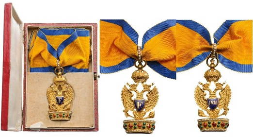
The Imperial Austrian Order of the Iron CrownLA GALERIE NUMISMATIQUE4.2(149)See Sold PriceFeb 25, 2024
Honour Badge for the Professors of the University in NaplesLA GALERIE NUMISMATIQUE4.2(149)See Sold PriceFeb 25, 2024
Romantic Dancing Couple Bronze SculptureWeatherham Estate Treasures3.9(157)See Sold PriceMar 07, 2024
Solid Romantic "Dancing Tango" Bronze Sculpture On Marble Base - 20lbsWeatherham Estate Treasures3.9(157)See Sold PriceMar 07, 2024
Honore Daumier France 1808-1879 Lithograph La Bon Argument Ltd Ed 500Global Auctions Company4.3(36)See Sold PriceMar 03, 2024
Chuspa, Departments of La Paz or Oruro, C. 1750-1850Material Culture4.6(765)See Sold PriceFeb 29, 2024
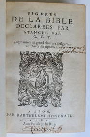
1582 FIGURES DE LA BIBLE antique ILLUSTRATED w/ 430 WOODCUTS RARE 16th CENTURYJasper524.5(9.8k)See Sold PriceFeb 27, 2024
CÉSAR LÓPEZ OSORNIO (La Plata, Argentina, 1930-2015). Untitled, 1980. Acrylic on canvas. SignedSetdart Auction House4.1(22)See Sold PriceMar 05, 2024
Carte de L'Algérie et de la Régence de Tunis' ANDRIVEAU-GOUJON Algeria 1850 mapJasper524.5(9.8k)See Sold PriceFeb 28, 2024
Rare 19thc Colton Map, Argentine Republic, Chile, Uruguay, PataguayConnoisseur Auctions4(333)See Sold PriceMar 16, 2024
MAUPASSANT GUY DE: (1850-1893) 'If my request would embarrass M. Massenet too much, please tellInternational Autograph Auctions Europe S.L.4.5(52)See Sold PriceMar 14, 2024
2.3 ctw Certified VS/SI Diamond Halo Ring 18k Yellow GoldPacific Global Auction3.9(272)See Sold PriceJul 27, 2024