ATLAS of ANTIENT GEOGRAPHY by SAMUEL BUTLER 1843John McInnis Auctioneers,LLC4.6(502)See Sold PriceFeb 24, 2024
18TH C. ANTIQUE MAP: FRENCH & INDIAN WAR, FRAMEDThomaston Place Auction Galleries4.4(386)See Sold PriceFeb 24, 2024
Rand McNally Railroad Map Cabinet w/ 21 Railroad MapsRail & Road Auctions4.6(165)See Sold PriceMar 08, 2024
Keith Haring - Ink on New York Map, Best Buddies, Inscribed, Signed, and DatedSapphire Auction Gallery4(67)See Sold PriceMar 02, 2024
LATE 17TH C. FRENCH MAP OF THE NEW WORLD BY ALEXIS-HUBERT JAILLOT (1632-1712)Thomaston Place Auction Galleries4.4(386)See Sold PriceFeb 24, 2024
Central Railroad of New Jersey Map of Sandy Hook Route-ca. 1903JM Hobby Supply and Railroad Artifact Auctions4.4(126)See Sold PriceFeb 24, 2024
Lot of Six Mixed Atlas Box Cars-HO Scale-New in BoxJM Hobby Supply and Railroad Artifact Auctions4.4(126)See Sold PriceFeb 25, 2024
Rand McNally/Santa Fe Railroad Map of Iowa-1912JM Hobby Supply and Railroad Artifact Auctions4.4(126)See Sold PriceFeb 24, 2024
NICOLAES VISSCHER (NETHERLANDS, 1618-1709) MAP OF THE NEW WORLDThomaston Place Auction Galleries4.4(386)See Sold PriceFeb 24, 2024
17TH C. WORLD MAP BY NICOLAES VISSCHER (NETHERLANDS, 1618-1709)Thomaston Place Auction Galleries4.4(386)See Sold PriceFeb 24, 2024
Lot of Six Mixed Atlas Cabooses-HO Scale-New in BoxJM Hobby Supply and Railroad Artifact Auctions4.4(126)See Sold PriceFeb 25, 2024
Sold4 English Maps & EngravingsFour (4) English maps and engravings, including Ogibly, Speed, Chavane. 1st item: "98. The Road from Shrewsbury to Chester to Holywell Co. Flint.", by John Ogilby (United Kingdom, 1600-1676), from hisSee Sold Price
4 English Maps & EngravingsFour (4) English maps and engravings inc. Ogibly, Speed, Chavane. 1st item: "98. The Road from Shrewsbury to Chester to Holywell Co. Flint.", by John Ogilby (United Kingdom, 1600-1676), from his "BritSee Sold Price
1630 EGYPT MAP copper engraving ANTIQUE from ENGLISH ED. Mercator-Hondius AtlasDecorative copper engraving map of EGYPT From an English Edition of the Mercator-Hondius Atlas. Amsterdam; 1630 size 4 1/4 by 7" (including margins 6 3/4 by 8 3/4") Henricus Hondius (1597-1651) was aSee Sold Price
1824 GAZETTEER of STATE of VERMONT antique AMERICANAGAZETTEER of THE STATE of VERMONT Montpelier, E.P. Walton & Author; 1824. Full calf Missing maps and engravings, some foxing, worn binding Size 4.5 by 7" Text in English Reserve: $70.00 Shipping:See Sold Price
1824 GAZETTEER of STATE of VERMONT antique AMERICANAGAZETTEER of THE STATE of VERMONT Montpelier, E.P. Walton & Author; 1824. Full calf Missing maps and engravings, some foxing, worn binding Size 4.5 by 7" Text in English Reserve: $70.00 Shipping:See Sold Price
1824 GAZETTEER of STATE of VERMONT antique AMERICANAGAZETTEER of THE STATE of VERMONT Montpelier, E.P. Walton & Author; 1824. Full calf Missing maps and engravings, some foxing, worn binding Size 4.5 by 7" Text in English Reserve: $70.00 Shipping:See Sold Price
1630 MAP OF PERSIA copper engraving ANTIQUE from English Mercator-Hondius AtlasDecorative hand colored copper engraving map of PERSIA From an English Edition of the Mercator-Hondius Atlas. Amsterdam; 1630 size 5 1/2 by 7" (including margins 6 1/4 by 7 3/4") Henricus Hondius (159See Sold Price
SoldWales.- Speed (John) Montgomery Shire, county map,NO RESERVE Wales.- Speed (John) Montgomery Shire, county map of Montgomery, engraving on laid paper with armorial watermark, with hand-colouring, sheet 387 x 510 mm. (15 1/4 x 20 1/8 in), English textSee Sold Price
SoldJOHN TALLIS (English, 1817-1876), South AmericaJOHN TALLIS (English, 1817-1876) Map of South America Hand-colored engraving on paper Size: 7 3/8" L x 5 3/8" W (sight); 14 3/4" L x 12 3/4" W (overall) CONDITIONSee Sold Price
SoldEMMANUEL BOWEN (English, 18th century). A Map of TuEMMANUEL BOWEN (English, 18th century). A Map of Turkey in Europe, Engraving with hand coloring. London, circa 1750 - 14 1/4 x 17 in.See Sold Price
Sold17TH CENTURY ENGLISH "STRIP MAP".The road from King's Lyn Norf to Harwich..., by John Ogilby, "His Ma[jes]ties Cosmographer", London, 1675, hand colored engraving paper. Toning, minor foxing, minor losses. 14 1/4"h. 18"w. Ogilby publSee Sold Price
Speed, Map of AsiaAsia. John Speed (1552-1629). Engraved map. London: G. Humble, 1626. 17 1/2 x 21 3/4 inches sheet, 26 1/2 x 31 1/2 inches framed. This beautiful carte-a-figures map is the first English printed map ofSee Sold Price
SoldSidney Hall Map of Devonshire PrintFramed and matted print of the Sidney Hall engraving "Map of Devonshire" Devon County, England circa 1830. Gilt frame measures 18-1/4" in height by 22-1/4" in width with the sight image measuring 7-3/See Sold Price
SoldEnglish School An Accurate Map of the Islands ofEnglish School coloured engraving, An Accurate Map of the Islands of Malta, Goze & Cuming, 4 x 8.25 ins.See Sold Price
1871 BIBLE ANALYSIS HITCHCOCK'S in ENGLISH antique AMERICANA ILLUSTRATED w/ MAPSHITCHCOCK'S NEW AND COMPLETE ANALYSIS OF THE HOLY BIBLE Illustrated with steel engravings and maps Original 3/4 leather binding with title in gilt. Gilt edges. Very Good interior condition, wear of thSee Sold Price
Sold4 Engravings of Maps of Jerusalem and the Land ofFour impressive engravings of Jerusalem, the Temple and the Land of Israel. * Engraving with an early map of the Land of Israel, including a description of the Temple. English. 38x50 cm. Fine-very finSee Sold Price
SoldEnglish History.- Knight (Charles, ed.) London, 6 vol.English History.- Knight (Charles, ed.) London, 6 vol. in 3, FIRST EDITION, numerous wood engravings, contemporary calf gilt, a.e.r., 1841-44; Green (John Richard) History of the English People, 4 volSee Sold Price
Ortelius Map of Japan, English TextORTELIUS, Abraham (1527-1598). Japoniae Insulae Descriptio. Engraved map with original hand color in full. London: John Norton, 1606 [English Text on Verso]. 17 1/4" x 22" sheet, 24" x 28" framed. ComSee Sold Price
SoldThe Road from Bristol to Banbury...[Verso:]The RoaThomas Gardner, The Road from Bristol to Banbury...[Verso:]The Road from Cockfield to Yarmouth, engraving 1719, from Pocket Guide for the English Traveller, 1719. , 4.5 x 7.5 4.5 x 7.5See Sold Price
SoldMap of New South Wales, 1902Map: New South Wales, 1902 Original engraving from Pictoral Atlas of the World by George Cram, 1902. Dimensions: 11 3/4" x 14 1/2" Please note that this lot has a confidential reserve. When you leaveSee Sold Price
Ortelius Map of Japan, with Rare English TextORTELIUS, Abraham (1527-1598). Japoniae Insulae Descriptio. Engraved map with original hand color in full. London: John Norton, 1606 [English Text on Verso]. 17 1/4" x 22" sheet, 24" x 28" framed. ComSee Sold Price
Thomas Moule Map of CambridgeshireCambridgeshire. Thomas Moule (1784-1851). Handcolored steel engraving. From The English Counties Delineated, 1842. 10 3/4 x 8 1/4 inches sheetSee Sold Price
SoldMoll Map of Island of BermudosThe Island of Bermudos...Herman Moll (c.1654-1732). Engraved map with original hand color in outline. London, c. 1708. 9 1/2 x 13 1/4 inches sheet. Striking full color example of this Moll's map of BeSee Sold Price
Colton: Antique Map of Environs of London, 1856Original engraving of the Environs of London with a detailed decorative border. Engraved by J. H. Colton, New York, 1856. Displayed in a handmade mat. Dimensions: 19 1/4" x 22" Joseph Hutchins ColtonSee Sold Price
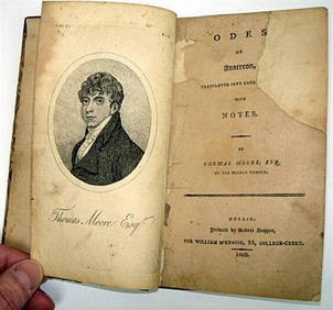
Rare 1803 Thomas Moore Odes of Anacreon 1st Edition Lodon PrintingLuis Porretta Fine Arts4.3(10)See Sold PriceMar 02, 2024
OFFER VAN ABRAHAM Book Of Genesis in Engravings c1700 Amsterdam Very rare!Luis Porretta Fine Arts4.3(10)See Sold PriceMar 02, 2024
MARTINET / DE VRIES Catechism of Nature 4 Vol. Set c1788 Engravings Rare!Luis Porretta Fine Arts4.3(10)See Sold PriceMar 02, 2024
Weavers Boy Poems by Chauncy Hare Townsend 1825 Calf BindingLuis Porretta Fine Arts4.3(10)See Sold PriceMar 02, 2024
JAN VAN DER DESYATER c1732 First Edition Thoughts On Sleepless Nights Rare!Luis Porretta Fine Arts4.3(10)See Sold PriceMar 02, 2024
17TH C. ENGLISH LINEAR MAP BY OGILBY, FRAMEDThomaston Place Auction Galleries4.4(386)See Sold PriceFeb 24, 2024
PAUL SANDBY Copperplate Mezzotint Landscape 1738 Framed & SuperbLuis Porretta Fine Arts4.3(10)See Sold PriceMar 02, 2024
THOMAS MOULE 1837 Colored Map of Warwickshire Framed vgcLuis Porretta Fine Arts4.3(10)See Sold PriceMar 02, 2024
Joseph Martin Kronheim Pair Early Color Glamor Prints c1850Luis Porretta Fine Arts4.3(10)See Sold PriceMar 02, 2024
THOMAS KEMPIS Imitation Of Christ c1890 Superb BindingLuis Porretta Fine Arts4.3(10)See Sold PriceMar 02, 2024
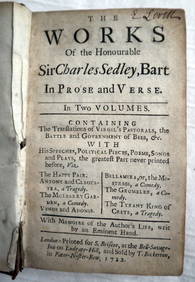
CHARLES SEDLEY BART Works In Prose c1722 1st Edition Full Calf SCARCE!Luis Porretta Fine Arts4.3(10)See Sold PriceMar 02, 2024
1738 BIBLE in DUTCH ILLUSTRATED w/ MAPS MASSIVE FOLIO in DUTCH antique BIBLIAJasper524.5(9.8k)See Sold PriceFeb 27, 2024
Framed Collection Engravings & A Map From The Excursions In The County Of Sussex Published In 1822Rapid Estate Liquidators and Auction Gallery4.5(1.1k)See Sold PriceMar 01, 2024
John Senex Map of Louisiana & Mississippi RiverWillow Auction House4.5(283)See Sold PriceMar 14, 2024


![The Road from Bristol to Banbury...[Verso:]The Roa (1 of 1)](https://p1.liveauctioneers.com/457/2714/1174435_1_x.jpg?height=282&quality=70)