Vintage Ca. 1940's International Panel Delivery Truck Converted into Stationary Food Truck, WasSwisher Bros. Auction LLC4.4(241)See Sold PriceFeb 25, 2024
Martin Custom Acoustic Guitar 000 Body Style Rosewood with Hard CaseHess Fine Auctions4.5(197)See Sold PriceMar 02, 2024
1968 Gibson LG-0 Acoustic Dreadnought Parlor GuitarHess Fine Auctions4.5(197)See Sold PriceMar 02, 2024
Replica Robinson 1862 Sharps CarbineSchmidt's Antiques Inc. Since 19114.8(431)See Sold PriceMar 02, 2024
PAIR (18th c) OF FLINTLOCK DUELING PISTOLSJohn McInnis Auctioneers,LLC4.6(502)See Sold PriceFeb 24, 2024
PAIR T KETLAND of LONDON .60 CAL FLINTLOCK PISTOLSJohn McInnis Auctioneers,LLC4.6(502)See Sold PriceFeb 25, 2024
Gibson ES335 Semi Hollow Vintage Sunburst Electric Guitar with Certificate of Authenticity Hand MadeHess Fine Auctions4.5(197)See Sold PriceMar 02, 2024
WALT DISNEY WORLD - Figment Animatronic Character Skin from EPCOT's Journey Into ImaginationPropstore4.2(6)See Sold PriceMar 12, 2024
Lot Of 3 Early Large Three-Ring Binders Full Of Thousands Of StampsRbfinearts4.4(571)See Sold PriceFeb 24, 2024
A FINE PERSIAN MALAYER PRAYER RUG WITH CYPRESS C. 1860Soulis Auctions4.8(953)See Sold PriceFeb 24, 2024
Thomas Hart Benton; 20thC. American Regionalist Oil SignedMid-Hudson Auction Galleries4.4(468)See Sold PriceFeb 24, 2024
Fender USA Stratocaster Electric Guitar Classic Candy Red and White Original Stickers with Gig BagHess Fine Auctions4.5(197)See Sold PriceMar 02, 2024
1986 Fender Stratocaster Japan Blue-Green with White Pickguard and Gig Bag JapaneseHess Fine Auctions4.5(197)See Sold PriceMar 02, 2024
Sold*ANTIQUARIAN 17TH C. HANDCOLORED ENGRAVED MAPAmerica's northeast state coast line with Massachusetts, New York and possibly Virginia, as well as unexplored provinces of Canada including Quebec, approximate plate size 15" x 20", frame 21 1/2" x 2See Sold Price
Sold17th C. Hand Colored Engraved Map of Walachia etc.Including parts of Walachia, Serbia, Bulgaria and Romania, from Gerard Mercator's Atlas Minor, published by Jodocus Hondius, Amsterdam, 1610. matted and framed, not examined out of frame / in as-foundSee Sold Price
Sold17th C. Hand-Colored Map of Tabula MagellanicaA 17th C. hand-colored engraved map of Tabula Magellanica, by William Blaeu. An important early map of South America showing the Strait of Magellan. Framed under glass. Mat opening: 16-1/4in x 21-1/2iSee Sold Price
Sold17th C. Hand-Colored Map of Bituricum DucatusA 17th C. hand-colored engraved map of Bituricum Ducatus, France, by William Blaeu, circa 1635. Framed under glass. Mat opening:15-1/2in x 20in.See Sold Price
17th c. Hand-colored Engraved Double-page World Map17th c. Hand-colored Engraved Double-page World Map Entitled DIVERSITÉ DES OMBRES ET DIVERSE SITUATION DES HABITANS DE LA TERRE by Claude Buy de Mornas (17XX-1783), 1761 | One of 17 hand-coloured douSee Sold Price
Sold17th c. Hand-colored Engraved Double-page World Map17th c. Hand-colored Engraved Double-page World Map Entitled OBSERVATIONS SUR LES POINTS CARDINAUX. LIGNES, ET CIRCLES DE LA SPHÈRE by Claude Buy de Mornas (17XX-1783), 1761 | One of 17 hand-coloredSee Sold Price
SoldJohann Blaeu (Dutch, 1596-1673)Johann Blaeu (Dutch, 1596-1673), "Iura Insula, The Yle of Iura, one of the westerne Iles of Scotland", 17th c., hand-colored copper-engraved double-page map, after Timothy Pont, from one of Blaeu's atSee Sold Price
17th c. H/C Engraved Map DIVERSITÉ DES OMBRES ET DIVERS17th c. Hand-colored Engraved Double-page World Map Entitled DIVERSITÉ DES OMBRES ET DIVERSE SITUATION DES HABITANS DE LA TERRE by Claude Buy de Mornas (17XX-1783), 1761 | One of 17 hand-coloured douSee Sold Price
SoldHAND COLORED ENGRAVED MAP, "CANDIA", 17THCHAND COLORED ENGRAVED MAP, "CANDIA", BOOK PLATE, 17TH CENTURY. SHEET 17 1/2 X 21 3/4" (CENTER FOLD)See Sold Price
SoldJansson Map Central America and Caribbean 17th c.Jan Jansson (1588-1664), "Insulae Americanae in Oceano Septentrionali," ca. 1638-1647. Hand colored engraved map of Central America and the Caribbean with detailed place names along the coasts. This mSee Sold Price
Sold17th C. Map of New Netherlands - Nicholas Visscher"Novi Belgii Novaeque Angliae Nec Non partis Virginiae Tabula"--1656, hand colored engraved map, second state. Antique map depicting early view of America (or New Netherlands) with one of the first deSee Sold Price
SoldLOT (2) HANDCOLORED ENGRAVED MAPS, "NAVARRA" ANDLOT (2) HANDCOLORED ENGRAVED MAPS, "NAVARRA" AND "VALENTIA REGNUM", SIGNED G. BLAEU (DUTCH 17TH CENTURY) C.1650. PLATE 15 X 19 3/4"; 16 1/4 X 19 3/4"; FRAMED & GLAZED 25 1/2 X 29 1/2" **DUE TO THE SIZSee Sold Price
Sold17thC. Hand-colored Map FLANDRIA ET ZELANDIA COMITATUSFlanders Flandria Zeelandia c.1640 Belgium & Holland engraved hand colour map Flandria et Zelandia Comitatus [Flanders and Zeelandia County] Issued c.1640, by Matthäus Merian der Ältere (or "MaSee Sold Price
Sold1600s Early Map of the WorldSuperb Early Map of the World Viewed from the North Pole c. 17th Century, POLI ARCTICI [ARCTIC POLE] by Henrici Hondy, Choice Extremely Fine. 17" x 19.5" handcolored copper engraved map, with marginsSee Sold Price
Sold17th C. John Speed, Huntington & Ely MapJohn Speed (British, 1552-1629), "Huntington, both Shire and Shire Town with the ancient citie Ely Described," hand colored, double engraved-page map originally created by noted cartographer, John SpeSee Sold Price
SoldReproduction 17th c. Celestial Hemisphere MapFramed Reproduction 17th c. steel engraved & hand-colored 17 12" x 20 3/4" map, "Hemisphae Alis Coeli; Sphaeri Grarri Bore Et Terrae Caseno Phia" published in 1660 by Joannes Janssonius, depicting theSee Sold Price
Sold17th and 18th C. Maps of Florida and EnglandTwo 17th & 18th century maps. Item 1: Hand-colored and engraved map of West Florida, dated 1772. Titled "A Map of Part of West Florida, from Pensacola to the Mouth of the Iberville River, with a ViewSee Sold Price
Sold17th c. J. Blaeu (?) Engraved Map of Asia Minor17th c. J. Blaeu (?), 1596 - 1673 copper engraved map of Asia Minor, hand colored accents including land boarders, cities and sea serpents, hand colored figures and ships, highlighted with gold indicaSee Sold Price
Sold17th C. Hand-Colored Map of DorsetshyreA circa 1662 hand-colored British map of "Dorsetshyre" by John Speed (1551-1629) and engraved by Jodocus Hondius. Has an inset map of Dorchester upper left. Framed under glass. Mat opening: 15-1/2in xSee Sold Price
EARLY 17TH C MAP OF PORTUGAL HAND COLOREDSuperb hand-laid, hand colored paper map of Portugal engraved for Mercators Atlas Minor c. 1609. The map is oriented with North to the right. Very detailed with a lot of topographical information andSee Sold Price
Sold4 17TH/18TH C. ENGRAVED MAPSFOUR 17TH & 18TH CENTURY ENGRAVED MAPS each hand colored comprising "N.W. Coast of America" as explored by Captain Cook, publ. 1794 by Wm. Faden. 25 x 34 inches. "North America" by Robert de Vaugondy,See Sold Price
SoldMap, Cambridgeshire, 17th Century EngravingA framed engraved and hand-colored map of Cambridgeshire, engraved by Sutton Nichols, sold by Abel Swal and Aunsham & John Churchill. c.1695. Measures 17.25" x 14.75". Framed measurement 20.5" x 17.75See Sold Price
Sold(3) Antiquarian etched maps(3) Antiquarian etched maps, c/o "Scotia" from the book "L'Isole Piu Famose Del Mondo" by Tomaso Porcacchi (1575), "Asia" (hand-colored, 17th century), and "Ipswich" (18th century), largest 11-3/4" xSee Sold Price
Sold18TH C. HANDCOLORED ENGRAVED MAP OF AMSTERDAMDimensions: (Frame) H 15.75" x W 16", (Sight) H 9.75" x W 10.25" Condition: Some age toning and spotting.See Sold Price
LARGE LATE 17TH C. DUTCH CHART OF CANADA, GREAT LAKES, NEW FRANCE, LABRADOR, HUDSON BAY, BY PIERREThomaston Place Auction Galleries4.4(386)See Sold PriceFeb 24, 2024
17TH C. WORLD MAP BY NICOLAES VISSCHER (NETHERLANDS, 1618-1709)Thomaston Place Auction Galleries4.4(386)See Sold PriceFeb 24, 2024
LATE 17TH C. FRENCH MAP OF THE NEW WORLD BY ALEXIS-HUBERT JAILLOT (1632-1712)Thomaston Place Auction Galleries4.4(386)See Sold PriceFeb 24, 2024
17TH C. ANTIQUE MAP SIEGE OF LA ROCHELLE, FRANCE, FRAMEDThomaston Place Auction Galleries4.4(386)See Sold PriceFeb 24, 2024
17TH C. ENGLISH LINEAR MAP BY OGILBY, FRAMEDThomaston Place Auction Galleries4.4(386)See Sold PriceFeb 24, 2024
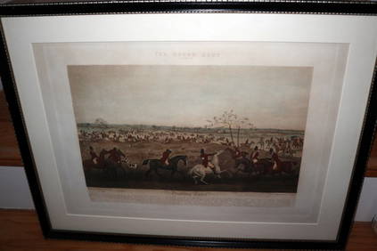
HENRY ALKEN / LEWIS Original 1835 Hand Colored Engraving Quorn Hunt DrawingLuis Porretta Fine Arts4.3(10)See Sold PriceMar 02, 2024
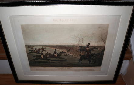
HENRY ALKEN / LEWIS Original 1835 Hand Colored Engraving Quron Hunt Snob Is BeatLuis Porretta Fine Arts4.3(10)See Sold PriceMar 02, 2024
OGILVY & BOWEN c1736 Original Map of Oxfordshire Berkshire Etc.Luis Porretta Fine Arts4.3(10)See Sold PriceMar 02, 2024
17th Century Hand Colored Engraved Map of GermanyGlobal Auctions Company4.3(36)See Sold PriceMar 03, 2024
Johann Homann Hand-Colored Map Engraving, c. 1730Auctions at Showplace4.5(726)See Sold PriceMar 17, 2024
Willem Blaeu, Etc. 17th C. Antiquarian Maps, 2Auctions at Showplace4.5(726)See Sold PriceMar 17, 2024
Map: A 17thC engraved and hand coloured map of Scotland titled Strath-Navernia / Strath Navern afterClaydon Auctioneers Ltd4.3(125)See Sold PriceFeb 26, 2024
Map: A 17thC engraved map of the British Isles titled A Generall Mapp of the Isles of GreatClaydon Auctioneers Ltd4.3(125)See Sold PriceFeb 26, 2024
Map: A 17thC engraved and hand coloured map of Bedfordshire after Robert Morden. Approx. 12 1/2" xClaydon Auctioneers Ltd4.3(125)See Sold PriceFeb 26, 2024
Map: A 17thC engraved and hand coloured map after Frederik de Wit (1630-1706) titled Nova Persiae,Claydon Auctioneers Ltd4.3(125)See Sold PriceFeb 26, 2024
Western Africa by Edward Weller. Early British/French settlements 1860 old mapJasper524.5(9.8k)See Sold PriceFeb 28, 2024
Western Africa by Edward Weller. Early British/French settlements 1859 old mapJasper524.5(9.8k)See Sold PriceFeb 28, 2024
1675: ANTIQUE ILLUSTRATED JULIUS CAESAR MAPS OF ROMAN HISTORYNY Elizabeth 4.3(84)See Sold PriceMar 03, 2024