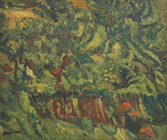
Chaim Soutine (Belarusian/French, 1893-1943) - La Petite Fille dans la VerdureFreeman's | Hindman4.5(158)See Sold PriceFeb 27, 2024
Elisabeth Frink (British, 1930-1993) - Harbinger Bird IFreeman's | Hindman4.5(158)See Sold PriceFeb 27, 2024
AMERICAN SEASCAPE PAINTING BY ROSS EMBROSE MOFFETTAntique Arena Inc.4.5(883)See Sold PriceMar 02, 2024
CHARLES HENRY GIFFORD (Massachusetts, 1839-1904), Luminist view of three sailboats in a quietEldred's4.7(423)See Sold PriceFeb 28, 2024
RARE MANHATTAN PROJECT GLASS LEADED FROM THE MANHATTAN PROJECT WORLD WAR II WW2 724 GRAMSCol. Christie Hatman Auctioneers4.4(355)See Sold PriceFeb 26, 2024
Estate Fresh Civil War Cavalry C. Roby 1863 With ScabbardRalph Fontaine Heritage Auctions Inc.4.7(236)See Sold PriceFeb 25, 2024
ABSTRACT ARAB LEBANESE OIL PAINTING BY ETEL ADNANAntique Arena Inc.4.5(883)See Sold PriceMar 02, 2024
Soldc. 1863 MAP Johnson's GEORGETOWNMapsc. 1863, JOHNSON’S GEORGETOWN AND THE CITY OF WASHINGTON...,” By Johnson and Ward, Choice Very Fine. 13.75” x 16.5,” hand-colored, lithographed map with ornate border. VignSee Sold Price
Soldc. 1863 MAP Johnson's GEORGETOWNc. 1863, JOHNSON'S GEORGETOWN AND THE CITY OF WASHINGTON...," By Johnson and Ward, Choice Very Fine. 13.75" x 16.5," hand-colored, lithographed map with ornate border. Vignettes of Washington sites prSee Sold Price
Sold1863 Civil War Map of Washington DCc. 1863, JOHNSON’S GEORGETOWN AND THE CITY OF WASHINGTON...,” By Johnson and Ward, Choice Extremely Fine. 13.75” x 16.5,” hand-colored, lithographed map with ornate border. VigSee Sold Price
Sold19th C. Johnsons Map of Florida19th C. Johnsons map of Florida, published by A.J. Johnson, New York in 1863,12.5"H. x 16"W., 19.25" x 22.5"H. overall.See Sold Price
SoldTwo Maps by Johnson & Ward, consisting of "Prussia,Two Maps by Johnson & Ward, consisting of "Prussia, Norway, Sweden, and Denmark," 19th c., hand colored, H.- 26 1/2 in., W.- 18 1/4 in.; together with Johnson & Ward, "West Indies," 1863-1866, hand coSee Sold Price
Sold(3) Maps of Civil War Washington DC Inc. Johnson'sGroup of (3) maps of Civil War-era Washington, DC: a) 1863 Johnson’s Georgetown And The City Of Washington The Capital Of The United States Of America. Johnson and Ward, (nd). From an edition oSee Sold Price
Great Britain showing all the railways…. DOWER. 4 sheets. 133x95cm c1863 mapTitle: "Great Britain showing all the railways…". DOWER. 4 sheets. 133x95cm c1863 map Description: Map of Great Britain showing all the railways & railway stations, the canals, navigable riversSee Sold Price
Sold1863 colored map Johnson's California & the westTitle: Johnson's California, Territories of New Mexico, Arizona, Colorado, Nevada and Utah Author: Johnson & Ward Description: Lithographed map, hand-colored. 40.2x59 cm. (15¾x23¼"), plus border andSee Sold Price
SoldJohnson’s Map of Washington & Oregon, 18631863 Map of Johnson’s Washington and Oregon. Johnson & Ward. 12.5 x 15.5 inches. Glimpse of this region shortly following the outbreak of the Civil War. Shows the state of Oregon with much of its eaSee Sold Price
Sold[ATHENS] KALERGIS, Emmanuel (19th cent.). Athenes etses environs. Paris: Lemercier, [c.a 1863]. Rare map of the city of Athens in very good condition showing the urban development, still modest in size, in the aftermath of the city's elevation to capitSee Sold Price
SoldOriginal Harper's Southern States Civil War Map, C 1863Antique original Harper's Southern States Civil War Map, Ca.1863. On Top reads, “Map Of The Southern States, including rail roads, country towns, state capital, country roads, the southern coast froSee Sold Price
Sold1863 JOHNSON'S MAP OF SOUTH AMERICAPublished by Johnson and Ward, dated 1863, 23.5 x 17.5 inches. Not examined outside of plastic wrap, appears excellent.See Sold Price
SoldOriginal Harper's Southern States Civil War Map, C 1863Antique original Harper's Southern States Civil War Map, Ca.1863. On Top reads, “Map Of The Southern States, including rail roads, country towns, state capital, country roads, the southern coast froSee Sold Price
Sold1863 Johnson Map of Florida -- Johnson's FloridaTitle/Content of Map: 1863 Johnson Map of Florida -- Johnson's Florida Date: 1863, New York CityCartographer: Johnson & Ward Size: 12 x 15.3 in. A nice Johnson map of Florida, showing only 37 countiesSee Sold Price
1863 Johnson Map of Florida -- Johnson's FloridaReserve Reduced! Title/Content of Map: 1863 Johnson Map of Florida -- Johnson's Florida Date: 1863, New York City Cartographer: Johnson & Ward Size: 12 x 15.3 in. A nice Johnson map of Florida, showinSee Sold Price
Sold1863 JOHNSON'S MAP OF ITALYA.J. Johnson, NY, map of the newly unified Kingdom of Italy, plus Sardinia, Malta, and Sicily. Professionally matted, 23.75 x 16.5 inches.See Sold Price
Sold1863 Johnson Map of Mexico -- Johnson's MexicoTitle/Content of Map: 1863 Johnson Map of Mexico -- Johnson's Mexico Date: 1863, New York Cartographer: A Johnson Size: 12.5 x 15.5 in. Very nice map of Mexico, color-coding the states. Great deal ofSee Sold Price
1863 Johnson Map of Florida -- Johnson's FloridaTitle: 1863 Johnson Map of Florida -- Johnson's Florida Cartographer: Johnson and Ward Year / Place: 1863, New York Map Dimension (in.): 12.1 X 15 in. This is an excellent map of Florida, showing onlySee Sold Price
Sold1863 Johnson Map of Maryland and Deleware -- Johnson'sTitle: 1863 Johnson Map of Maryland and Deleware -- Johnson's Deleware and Maryland Date: 1863, New York Cartographer: Johnson & Ward Size: 12.6 x 15.5 in. Additional Information: A very nice map of tSee Sold Price
1863 Johnson Map of US West -- Johnson's California Territories of New Mexico Arizona ColoradoTitle: 1863 Johnson Map of US West -- Johnson's California Territories of New Mexico Arizona Colorado Nevada and Utah Cartographer: Johnson & Ward Year / Place: 1863, New York Map Dimension (in.): 17.See Sold Price
Sold1863 Johnson Map of Georgia and Alabama -- Johnson'sTitle/Content of Map: 1863 Johnson Map of Georgia and Alabama -- Johnson's Georgia and Alabama Cartographer: A Johnson Year/Place: 1863, New York Size: 15.5 X 21.3 in. This is a very nice and highly dSee Sold Price
1863 Johnson Map of Florida -- Johnson's FloridaReserve Reduced! Title/Content of Map: 1863 Johnson Map of Florida -- Johnson's Florida Date: 1863, New York City Cartographer: Johnson & Ward Size: 12 x 15.3 in. A nice Johnson map of Florida, showinSee Sold Price
1863 Johnson Map of Georgia and Alabama -- Johnson'sTitle/Content of Map: 1863 Johnson Map of Georgia and Alabama -- Johnson's Georgia and Alabama Date: 1863, New York Cartographer: Johnson & Ward Size: 15.5 x 22 in. An attractive map of there two SoutSee Sold Price
Reproduction of 1863 Johnson Map of Georgia and AlabamaTitle/Content of Map: Reproduction of 1863 Johnson Map of Georgia and Alabama -- Johnson's Georgia and Alabama Date Printed: Original: 1863, New York Cartographer: Johnson & Ward Size: 15.5 x 22 in. ASee Sold Price
17TH C. WORLD MAP BY NICOLAES VISSCHER (NETHERLANDS, 1618-1709)Thomaston Place Auction Galleries4.4(394)See Sold PriceFeb 24, 2024
LATE 17TH C. FRENCH MAP OF THE NEW WORLD BY ALEXIS-HUBERT JAILLOT (1632-1712)Thomaston Place Auction Galleries4.4(394)See Sold PriceFeb 24, 2024
17TH C. ANTIQUE MAP SIEGE OF LA ROCHELLE, FRANCE, FRAMEDThomaston Place Auction Galleries4.4(394)See Sold PriceFeb 24, 2024
EARLY 18TH C. MAP OF ITALY, FRAMEDThomaston Place Auction Galleries4.4(394)See Sold PriceFeb 24, 2024
LATE 16TH C. MAP OF SCOTLAND BY MERCATOR, FRAMEDThomaston Place Auction Galleries4.4(394)See Sold PriceFeb 24, 2024
17TH C. MAP OF THE BERKSHIRES BY JOHN SPEED, FRAMEDThomaston Place Auction Galleries4.4(394)See Sold PriceFeb 24, 2024
18TH C. ANTIQUE MAP: FRENCH & INDIAN WAR, FRAMEDThomaston Place Auction Galleries4.4(394)See Sold PriceFeb 24, 2024
Willem Blaeu, Etc. 17th C. Antiquarian Maps, 2Auctions at Showplace4.6(744)See Sold PriceMar 17, 2024
Ancient Anchor by Rodell C. Johnson Signed and Numbered LithographAbsolute Auction Gallery4.5(58)See Sold PriceFeb 28, 2024
Estate Fresh Civil War Cavalry C. Roby 1863 With ScabbardRalph Fontaine Heritage Auctions Inc.4.7(236)See Sold PriceFeb 25, 2024
North west Africa. Liberia inset. Sahara Senegambia Guinea. COLTON 1863 mapJasper524.5(9.9k)See Sold PriceFeb 28, 2024
PRE COLONIAL WESTERN AFRICA. Shows Mountains of Kong. Tribes. WELLER 1863 mapJasper524.5(9.9k)See Sold PriceFeb 28, 2024
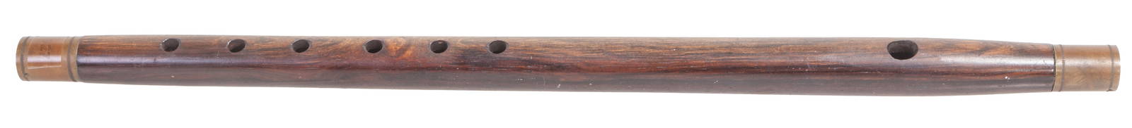
Civil War Metal Mounted Rosewood Fife, c. 1863, H.- 15 1/2 in., Dia.- 3/4 in.Crescent City Auction Gallery4.3(233)See Sold PriceMar 08, 2024
1962 C. Alan Johnson Alaskan Pottery Figure RachelArtemis Fine Arts4.8(1.4k)See Sold PriceFeb 26, 2024
1960-2009 titans/oilers signed poster framed 8 sigs-k.s. bud adams/c johnson-bas3 Kings Auction4.1(205)See Sold PriceFeb 26, 2024
1962 C. Inuit Ceramic "Seal Hunter" C. Alan JohnsonArtemis Fine Arts4.8(1.4k)See Sold PriceFeb 26, 2024


![[Tintype] Massive Bowie knife (1 of 1)](https://p1.liveauctioneers.com/7226/317626/170485482_1_x.jpg?height=282&quality=70&version=1706368022)
![[Ambrotype] Magnificent Portrait (1 of 1)](https://p1.liveauctioneers.com/7226/317626/170485477_1_x.jpg?height=282&quality=70&version=1706368022)


![[Tintype] Native American Man w/ Knife (1 of 2)](https://p1.liveauctioneers.com/7226/317626/170485453_1_x.jpg?height=282&quality=70&version=1706368022)
![[REES, Charles] Enlistedman w/ Bowie Knife (1 of 1)](https://p1.liveauctioneers.com/7226/317626/170485489_1_x.jpg?height=282&quality=70&version=1706368022)
![[Ambrotype] Wounded at Gettysburg (1 of 1)](https://p1.liveauctioneers.com/7226/317626/170485471_1_x.jpg?height=282&quality=70&version=1706368022)


![[Ambrotype] Young Soldier w/ Bowie Knife (1 of 1)](https://p1.liveauctioneers.com/7226/317626/170485459_1_x.jpg?height=282&quality=70&version=1706368022)

![[Daguerreotype] Soldier w/ Bowie Knife (1 of 2)](https://p1.liveauctioneers.com/7226/317626/170485458_1_x.jpg?height=282&quality=70&version=1706368022)
![[Tintype] Soldier w/ Flowers (1 of 1)](https://p1.liveauctioneers.com/7226/317626/170485495_1_x.jpg?height=282&quality=70&version=1706368022)
![[Tintype] Identified North Carolina Infantryman (1 of 2)](https://p1.liveauctioneers.com/7226/317626/170485474_1_x.jpg?height=282&quality=70&version=1706368022)


![[ATHENS] KALERGIS, Emmanuel (19th cent.). Athenes et (1 of 1)](https://p1.liveauctioneers.com/4096/288680/152743873_1_x.jpg?height=282&quality=70&version=1683550714)