Sold1729 MAP OF POLAND BY HERMAN MOLL1729 MAP OF POLAND BY HERMAN MOLL 1729 map of "Poland subdivided into its several Palatinates & c. Agreeable to Modern History" by Herman Moll, Geographer. In cardboard matting with a caption paper inSee Sold Price
Sold1729 MAP OF POLAND BY HERMAN MOLL1729 MAP OF POLAND BY HERMAN MOLL 1729 map of "Poland subdivided into its several Palatinates & c. Agreeable to Modern History" by Herman Moll, Geographer. In cardboard matting with a caption paper inSee Sold Price
1729 MAP OF POLAND BY HERMAN MOLL1729 MAP OF POLAND BY HERMAN MOLL 1729 map of "Poland subdivided into its several Palatinates & c. Agreeable to Modern History" by Herman Moll, Geographer. In cardboard matting with a caption paper inSee Sold Price
1729 MAP OF POLAND BY HERMAN MOLL1729 MAP OF POLAND BY HERMAN MOLL 1729 map of "Poland subdivided into its several Palatinates & c. Agreeable to Modern History" by Herman Moll, Geographer. In cardboard matting with a caption paper inSee Sold Price
Sold1729 POLAND MAP BY HERMAN MOLL1729 POLAND MAP BY HERMAN MOLL 1729 map of Poland "Subdivided into its several Palatinates & c. Agreeable to Modern History" by Herman Moll, Geographer. #24/102. In a cardboard matte with a caption paSee Sold Price
1729 POLAND MAP BY HERMAN MOLL1729 POLAND MAP BY HERMAN MOLL 1729 map of Poland "Subdivided into its several Palatinates & c. Agreeable to Modern History" by Herman Moll, Geographer. #24/102. In a cardboard matte with a caption paSee Sold Price
1729 POLAND MAP BY HERMAN MOLL1729 POLAND MAP BY HERMAN MOLL 1729 map of Poland "Subdivided into its several Palatinates & c. Agreeable to Modern History" by Herman Moll, Geographer. #24/102. In a cardboard matte with a caption paSee Sold Price
1729 POLAND MAP BY HERMAN MOLL1729 POLAND MAP BY HERMAN MOLL 1729 map of Poland "Subdivided into its several Palatinates & c. Agreeable to Modern History" by Herman Moll, Geographer. #24/102. In a cardboard matte with a caption paSee Sold Price
Soldc. 1729, Map of CAROLINAMapsBold Early Colonial Printed Map of “Carolina” by H. Moll c. 1729, Map of “CAROLINA,” by Herman Moll, England, Choice Extremely Fine. Map measures 8” x 11”, withSee Sold Price
SoldHerman Moll 1701 Map of PolandThis quality matted and framed hand-colored bookplate map of Poland is from 1701 bt Herman Moll. The map itself measures 12" tall X 8" across.See Sold Price
SoldMOLL, HERMAN. Map of Moscovy, Poland, Little TMOLL, HERMAN. Map of Moscovy, Poland, Little Tartary, and ye Black Sea * Arabia. Together, 2 engraved maps; first consisting of two sheets joined, 620x990 mm overall, second 185x270 mm; both with wideSee Sold Price
SoldMoll: Map of Poland, 1701Map of Poland. An original copperplate engraving published by Herman Moll in 1701. With text describing the Kingdom Of Poland. 7 x 7.5 " (map only) Please note that this lot has a reserve. When you leSee Sold Price
SoldMOLL - Map of Moscovy, Poland, Little Tartary anMAPS. - MOLL, Herman. Map of Moscovy, Poland, Little Tartary and ye Black Sea ...; A New Map of Denmark and Sweden ...London: printed for H. Moll, D. Midwinter, T. Bowles and P. Overton, [circSee Sold Price
SoldMOLL. Map of Carolina.MAP - MOLL, Herman. Carolina.London: after 1729. Engraved map (200x275 mm plate mark size). Condition: chips and short tears in the margins outside the plate mark. Cartographically the sameSee Sold Price
SoldMap of Newfoundland by Herman Moll 1729Map: New Found Land, St Laurens Bay, The Fishing Banks, Acadia, and Part of New Scotland Maker: Herman Moll Date: 1729 (1730-32) Size: 8 x 10.25 inches Newfoundland and Nova Scotia in original outlineSee Sold Price
SoldHerman Moll, Virginia and Maryland map(English, 1654-1732), hand colored map, dated 1729, 11 x 8 in. , framedSee Sold Price
SoldH. Moll, 1736, Map includes Moscovy & PolandAlso includes Little Tartary and the Black Sea. Dedicated to Peter Alexovitz, Absolute Lord of Russia. 1736. Constructed in 2 panels; hand colored. Tears to bottom at folds. Tears and losses to rightSee Sold Price
SoldHerman Moll Map of New France, 1717Herman Moll, "A Map of New France Containing Canada, Louisiana...in Nth. America", London, 1717; and "New England, New York, New Jersey and Pensilvania", London, 1729, known as the "Postal Map"; bothSee Sold Price
SoldMap of Moscovy, Poland, Litlle Tartary and Black Sea.London, 1700s, Herman Moll. Engraving on copper, watercolors painting. Image Size: 61,5x98 cm.See Sold Price
SoldMoll (Herman) Composite atlasMoll (Herman) Composite atlas,comprising 30 large, mostly double-page maps, the majority by Moll, including A Map of the East Indies, Map of North America, Map of Africa, Map of Moscovy, PolanSee Sold Price
SoldMoll (Herman) - Virginia and Maryland,the Chesapeake Bay area, engraved map with original hand-colouring in outline, 275 x 210mm., 1729; with A Map of the British and French Plantations in North America, covering New England, Nova Scotia,See Sold Price
SoldLarge Moll map of RussiaTitle: To His Most Serene and August Majesty Peter Alexovitz... This Map of Muscovy, Poland, Little Tartary, and ye Black Sea is most humbly dedicated... Author: Moll, Herman Description: Copper-engrSee Sold Price
SoldGrp: 13 Maps from Herman Moll Atlas MinorGroup of twelve maps from Herman Moll's (ca. 1654-1732) "Atlas Minor," together with the colophon from the book. Includes maps of Hungary and Transylvania, Poland, Russia ("the Dominion of Muscovy"),See Sold Price
SoldCaspian Sea. Detailed map. Best to dateTitle: Caspian Sea. Detailed map. Best to date Description: By. Herman Moll. From. Atlas minor. Published. London. Date/ Period: 1729-1736 Materials: Copperplate engraved. Dimensions: 13 1/2 x 9 “ RSee Sold Price
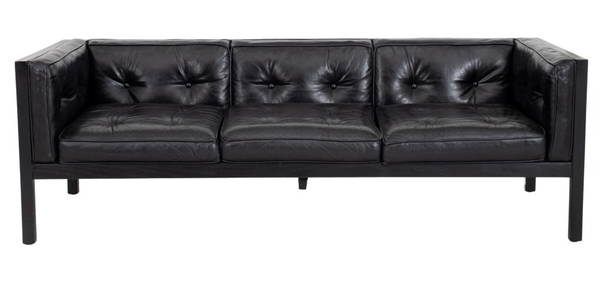
George Nelson Herman Miller Leather "Cube" SofaAuctions at Showplace4.5(726)See Sold PriceMar 03, 2024
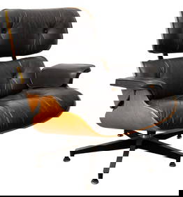
Charles & Ray Eames for Herman Miller Lounge ChairAuctions at Showplace4.5(726)See Sold PriceMar 03, 2024
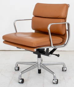
Eames for Herman Miller Executive Soft Pad ChairAuctions at Showplace4.5(726)See Sold PriceMar 03, 2024
Herman Rohde Signed Antique American Original Impressionist Sheep Landscape Framed Oil PaintingCurated Gallery Auctions4.6(120)See Sold PriceFeb 25, 2024
Charles and Ray Eames (1907-1978 and 1912-1988), Four DCW molded plywood dining chairs for HermanJohn Moran Auctioneers, Inc.4.7(453)See Sold PriceFeb 27, 2024
[MAP]. NICHOLLS, Sutton (1668-1729). An Epitome of Sr. Will...Potter & Potter Auctions4.6(539)See Sold PriceMar 07, 2024
1736 LARGE MAP OF SILESIA POLAND OPPAVIENSIS antique 25 by 34 3/4"Jasper524.5(9.8k)See Sold PriceFeb 27, 2024
1729 GERMANIA SACRA by M. Hansiz BLINDSTAMPED PIGSKIN antique FOLIO w/ MAPJasper524.5(9.8k)See Sold PriceFeb 27, 2024
1736 LARGE MAP OF SILESIA POLAND KARNOVIENSIS antique 25 x 4 3/4" Duchy of KrnovJasper524.5(9.8k)See Sold PriceFeb 27, 2024
Historic Map - The Duchy of Silesia, Poland, Wilkinson, 1792.Proverde Auctions4.3(3)See Sold PriceFeb 28, 2024
Antique Map of Poland, 1700 by Guillaume De Lisle, ParisAntiques Online Auctions4.6(407)See Sold PriceMar 14, 2024
Herman Moll A New Map of Ye North Parts of AmericaWillow Auction House4.5(283)See Sold PriceMar 14, 2024


![[MAP]. NICHOLLS, Sutton (1668-1729). An Epitome of Sr. Will... (1 of 1)](https://p1.liveauctioneers.com/928/318880/171361281_1_x.jpg?height=282&quality=70&version=1707501302)


