Herman Moll A New Map of Ye North Parts of AmericaWillow Auction House4.5(284)See Sold PriceMar 14, 2024
SoldH. Moll, 1736, Map includes Moscovy & PolandAlso includes Little Tartary and the Black Sea. Dedicated to Peter Alexovitz, Absolute Lord of Russia. 1736. Constructed in 2 panels; hand colored. Tears to bottom at folds. Tears and losses to rightSee Sold Price
SoldMOLL - Map of Moscovy, Poland, Little Tartary anMAPS. - MOLL, Herman. Map of Moscovy, Poland, Little Tartary and ye Black Sea ...; A New Map of Denmark and Sweden ...London: printed for H. Moll, D. Midwinter, T. Bowles and P. Overton, [circSee Sold Price
SoldMoll MOSCOVY POLAND LITTLE TARTARY C1730 CopperDetails: MOLL, Herman (1654-1732). Moscovy, Poland, Little Tartary. London: H. Moll, T. & J. Bowles, P. Overton & J. King, [circa 1730]. Copper-engraved map, with original outline colour, in excellenSee Sold Price
SoldH. Moll, circa 1736, Map of Great BritainConstructed in 2 panels, hand colored. Tears to edges at folds. Staining and mold to right side. 39-1/2" high x 25" wide. IMPORTANT: Before bidding, please read the terms and conditions. When you regiSee Sold Price
SoldMOLL, HERMAN. Map of Moscovy, Poland, Little TMOLL, HERMAN. Map of Moscovy, Poland, Little Tartary, and ye Black Sea * Arabia. Together, 2 engraved maps; first consisting of two sheets joined, 620x990 mm overall, second 185x270 mm; both with wideSee Sold Price
Sold1736 Hand Colored “Barbary Coast Map” H. MollHistoric Maps 1736 Hand Colored “Barbary Coast Map” H. Moll 1736-Dated, Hand-Colored Copper Plate Engraved Map titled, “The west part of Barbary containing Fez, Marocco, Algiers and Tunis. By H.See Sold Price
SoldMap. NW Germany, H. Moll, 1736Map. NW Germany, H. Moll, 1736 Title: The North West Part Of Germany Artist: Herman Moll Publisher: Thomas Bowels Engraver: Herman Moll Description: Copper engraving, uncolored as published, of the NoSee Sold Price
SoldMap of Persia by H. Moll & Plan of ConstantinopleMap of Persia by H. Moll & Plan of Constantinople. This lot includes a map of Persia by H. Moll Geographer and an engraving of the plan of Constantinople by Bosphoror Thracio. Larger measures 13 incheSee Sold Price
Map of Persia by H. Moll & Plan of ConstantinopleMap of Persia by H. Moll & Plan of Constantinople. This lot includes a map of Persia by H. Moll Geographer and an engraving of the plan of Constantinople by Bosphoror Thracio. Larger measures 13 incheSee Sold Price
SoldMoll (Herman) Composite atlasMoll (Herman) Composite atlas,comprising 30 large, mostly double-page maps, the majority by Moll, including A Map of the East Indies, Map of North America, Map of Africa, Map of Moscovy, PolanSee Sold Price
SoldH. Moll, 1712, Map of Germany, HungaryAlso includes Transylvania and the Suisse. Dedicated to His Grace John Duke of Marleborough, Prince of Mindelheim. Hand colored. Constructed in 4 panels. Creasing, particularly at panel attachments. TSee Sold Price
SoldH. Moll, circa 1730s, Maps of Spain & PortugalAlso includes map of France.Spain & Portugal: Dedicated to His Grace John, Duke of Argile. Constructed in 4 panels, hand colored. Tears to bottom at panel creases; adhesive has failed down middle paneSee Sold Price
SoldMap of Moscovy, Poland, Litlle Tartary and Black Sea.London, 1700s, Herman Moll. Engraving on copper, watercolors painting. Image Size: 61,5x98 cm.See Sold Price
H. Moll, 1715, Map of Brunswick-LunenburgDedicated to His Most Sacred Majesty George, King of Great Britain. Constructed in 4 panels. Hand colored. Tears to top and bottom at panel creases, tear to cartouche area also includes losses. WaterSee Sold Price
SoldEnglish handpainted map, 18th/19thc., of Poland, LEnglish handpainted map, 18th/19thc., of Poland, Little Tartary, Black Sea, printed for H. Moll. 24”x38”See Sold Price
SoldSouth America weste coast by H. Moll c.1720Title: Three maps of features of the West Coast of South America, on one sheet Author: Moll, Herman Description: 3 copper-engraved maps on 1 sheet, slight hand-coloring. Includes: A Map of the Isle ChSee Sold Price
H. Moll, circa 1715, Map of FlandersAlso know as Austrian Netherlands. Les Provinces des Pays-Bas Catholiques. Dedicated to His Grace Iames Duke of Ormond. Major tears to bottom of map. Hand colored. Tears to bottom left includes loss iSee Sold Price
Maps of regions of South America by H. Moll 1740Title: Two maps of regions of South America Author: Moll, Herman Description: Includes: A Map of Chili, Patagonia, Part of La Plata &c. 25x18 cm. (10x7"). * A Map of Terra Firma, Guiana and the AntillSee Sold Price
1745 Moll Map of European Russia -- Russia or Moscovy with its Acquisitions &c. in Sweden AgreeableTitle: 1745 Moll Map of European Russia -- Russia or Moscovy with its Acquisitions &c. in Sweden Agreeable to Modern History Cartographer: H Moll Year / Place: 1745, London Map Dimension (in.): 10.2 XSee Sold Price
1745 Moll Map of European Russia -- Russia or MoscovyTitle: 1745 Moll Map of European Russia -- Russia or Moscovy with its Acquisitions &c. in Sweden Agreeable to Modern History Cartographer: H Moll Year / Place: 1745, London Map Dimension (in.): 10.2 XSee Sold Price
1745 Moll Map of European Russia -- Russia or MoscovyTitle: 1745 Moll Map of European Russia -- Russia or Moscovy with its Acquisitions &c. in Sweden Agreeable to Modern History Cartographer: H Moll Year / Place: 1745, London Map Dimension (in.): 10.2 XSee Sold Price
1745 Moll Map of European Russia -- Russia or MoscovyTitle: 1745 Moll Map of European Russia -- Russia or Moscovy with its Acquisitions &c. in Sweden Agreeable to Modern History Cartographer: H Moll Year/Place: 1745, London Size: 10.2 X 7.6 in. AdditionSee Sold Price
1745 Moll Map of European Russia -- Russia or MoscovyTitle: 1745 Moll Map of European Russia -- Russia or Moscovy with its Acquisitions &c. in Sweden Agreeable to Modern History Cartographer: H Moll Year / Place: 1745, London Map Dimension (in.): 10.2 XSee Sold Price
SoldGrp: 13 Maps from Herman Moll Atlas MinorGroup of twelve maps from Herman Moll's (ca. 1654-1732) "Atlas Minor," together with the colophon from the book. Includes maps of Hungary and Transylvania, Poland, Russia ("the Dominion of Muscovy"),See Sold Price
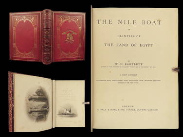
1880 Niles Boat Egypt Voyages Sphinx Pyramids Valley of Kings Illustrated MAPSSchilb Antiquarian Rare Books4.8(422)See Sold PriceMar 31, 2024
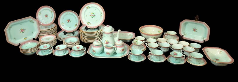
SIX CARVED AND DECORATED PIECES.Amelia Jeffers, Auctioneers & Appraisers4.5(116)See Sold PriceMar 09, 2024
1736 LARGE MAP OF SILESIA POLAND OPPAVIENSIS antique 25 by 34 3/4"Jasper524.5(9.8k)See Sold PriceFeb 27, 2024
1736 LARGE MAP OF SILESIA POLAND KARNOVIENSIS antique 25 x 4 3/4" Duchy of KrnovJasper524.5(9.8k)See Sold PriceFeb 27, 2024
Jules Verne, Mirifiques Aventures de Maitre, Aux HarponsLion and Unicorn4.8(1.9k)See Sold PriceMar 03, 2024
Jules Verne, Le Testament d'un Excentrique, Aux HarponsLion and Unicorn4.8(1.9k)See Sold PriceMar 03, 2024
Jules Verne, Mirifiques Aventures de Maitre, Aux HarponsLion and Unicorn4.8(1.9k)See Sold PriceMar 03, 2024
Jules Verne, P'tit Bonhomme, Aux Harpons, Red CoverLion and Unicorn4.8(1.9k)See Sold PriceMar 03, 2024
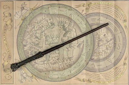
Universal Studios Harry Potter Wand BRapid Estate Liquidators and Auction Gallery4.5(1.1k)See Sold PriceFeb 28, 2024
Jules Verne, L'Etoile du Sud, Hachette & Cie, Red CoverLion and Unicorn4.8(1.9k)See Sold PriceMar 10, 2024
Jules Verne, De La Terre a La Lune, Au Steamer Red MacaronLion and Unicorn4.8(1.9k)See Sold PriceMar 10, 2024
Jules Verne, L'Archipel en Feu, Au Steamer Red MacaronLion and Unicorn4.8(1.9k)See Sold PriceMar 10, 2024
Jules Verne, L'Etoile du Sud, Au Steamer Red MacaronLion and Unicorn4.8(1.9k)See Sold PriceMar 10, 2024