ATLAS of ANTIENT GEOGRAPHY by SAMUEL BUTLER 1843John McInnis Auctioneers,LLC4.5(494)See Sold PriceFeb 24, 2024
18TH C. ANTIQUE MAP: FRENCH & INDIAN WAR, FRAMEDThomaston Place Auction Galleries4.4(386)See Sold PriceFeb 24, 2024
Rand McNally Railroad Map Cabinet w/ 21 Railroad MapsRail & Road Auctions4.6(165)See Sold PriceMar 08, 2024
Keith Haring - Ink on New York Map, Best Buddies, Inscribed, Signed, and DatedSapphire Auction Gallery3.9(67)See Sold PriceMar 02, 2024
LATE 17TH C. FRENCH MAP OF THE NEW WORLD BY ALEXIS-HUBERT JAILLOT (1632-1712)Thomaston Place Auction Galleries4.4(386)See Sold PriceFeb 24, 2024
Central Railroad of New Jersey Map of Sandy Hook Route-ca. 1903JM Hobby Supply and Railroad Artifact Auctions4.4(126)See Sold PriceFeb 24, 2024
Lot of Six Mixed Atlas Box Cars-HO Scale-New in BoxJM Hobby Supply and Railroad Artifact Auctions4.4(126)See Sold PriceFeb 25, 2024
Rand McNally/Santa Fe Railroad Map of Iowa-1912JM Hobby Supply and Railroad Artifact Auctions4.4(126)See Sold PriceFeb 24, 2024
NICOLAES VISSCHER (NETHERLANDS, 1618-1709) MAP OF THE NEW WORLDThomaston Place Auction Galleries4.4(386)See Sold PriceFeb 24, 2024
17TH C. WORLD MAP BY NICOLAES VISSCHER (NETHERLANDS, 1618-1709)Thomaston Place Auction Galleries4.4(386)See Sold PriceFeb 24, 2024
Lot of Six Mixed Atlas Cabooses-HO Scale-New in BoxJM Hobby Supply and Railroad Artifact Auctions4.4(126)See Sold PriceFeb 25, 2024
SoldHerman Moll Map of New France, 1717Herman Moll, "A Map of New France Containing Canada, Louisiana...in Nth. America", London, 1717; and "New England, New York, New Jersey and Pensilvania", London, 1729, known as the "Postal Map"; bothSee Sold Price
SoldMOLL, HERMAN. A Map of New France Containing Canada,MOLL, HERMAN. A Map of New France Containing Canada, Louisiana &c. in Nth America. Hand-colored engraved map of colonial North America. 7¾x10¾ inches sheet size, ample margins; mounted to foSee Sold Price
SoldHerman Moll A New Map of Great Britain 1717. TitlHerman Moll A New Map of Great Britain 1717. Title: 'A New Map of Great Britain According to the Newest and Most Exact Observations'. A large and very intricate map of the British isles with colouredSee Sold Price
SoldHERMAN MOLL COLONIAL-ERA MAP OF NORTH AMERICAMap: "A New Map of the North Parts of America claimed by France, under ye names of Louisiana, Mississipi [sic Mississippi], Canada, and New France with ye adjoining territories of England and Spain,"See Sold Price
SoldMoll, Herman, @New Map of the North Parts of AmMoll, Herman, "A New Map of the North Parts of America claimed by France under ye names of Louisiana, Mississippi, Canada and New France with ye Adjoyning Territories of England and Spain" , London, 1See Sold Price
SoldMoll: Antique Map of Colonial America New FranceTitle/Content of Map: Colonial America New France by Moll Date Printed: 1746 Cartographer: Thomas Salmom & Herman Moll Material/Medium: Paper Size: 14 1/2" x 9 1/2" Copperplate engraved. Published inSee Sold Price
SoldA New and Exact Map of France Dividid HERMAN MOLLDetails: MOLL, Herman (fl. 1678-1732). A New and Exact Map of France Dividid [sic] into all its provinces and acquisitions, according to the newest observations, and that accurate survey made by theSee Sold Price
SoldMOLL, HERMAN. A New Map of the North Parts ofMOLL, HERMAN. A New Map of the North Parts of America claimed by France. Two-sheet engraved map, 620x1030 mm sheet size, trimmed close just outside neatline; hand-colored in outline; a bit toned overaSee Sold Price
SoldEarly Map of North AmericaHerman Moll British (1654-1732)A NEW MAP OF THE NORTH PARTS OF AMERICA CLAIMED BY FRANCE UNDRE YE NAMES OF LOUISIANA, MISSISSIPPI, CANADA, AND NEW FRANCE WITH YE ADJOYNING TERRITORIES OF ENGLAND AND SSee Sold Price
SoldMOLL. A New Map of the North Parts of America claMAP - MOLL, Herman. A New Map of the North Parts of America claimed by France.London: printed for H. Moll, 1720. Engraved map (sheet size: 648x1045 mm.), hand-colored in outline, with small oSee Sold Price
SoldHermann Moll map of FranceCartographer: Herman Moll Title: A New and Exact Map of France Dividid into All its Provinces and Acquisitions, According to the Newest Observations, and that Accurate Survey Made by the King's CommanSee Sold Price
Moll (Herman) A New and Exact Map of FranceMoll (Herman) A New and Exact Map of France, engraved map of France with outline hand-colouring, large pictorial cartouche (uncoloured), tables at sides, 610 x 970mm., some browning to creasesSee Sold Price
SoldEarly French Colonies North America HERMAN MOLL C1732Details: MOLL, Herman (1654-1732). A New Map of ye North Parts of America claimed by France under ye Names of Louisiana, Mississipi, Canada & New France, with the Adjoyning Territories of England & SSee Sold Price
SoldMoll Engraved Map of AmericaA new map of the north parts of America claimed by France under ye names of Louisiana, Mississipi, Canada, and New France with ye adjoining territories of England and Spain. Herman Moll (1654-1732). ESee Sold Price
SoldMoll NEW AND EXACT MAP OF FRANCE C1720 Engraved MapDetails: MOLL, Herman. (1654-1732). A New and Exact Map of France Dividid into all its Provinces and Acquisitions, according to the Newest Observations, and that accurate Survey made by the King's CoSee Sold Price
MOLL, Herman (1654?-1732). A New and Exact Map ofMOLL, Herman (1654?-1732). A New and Exact Map of France. London, [ca 1730]. Engraved map of France, image 604 x 968 mm (sheet 628 x 995 mm) with hand-coloring. Allegorical cartouche depicting the artSee Sold Price
SoldMoll's large North America Calif. an islandTitle: A New Map of the North Parts of America claimed by France under ye names of Louisiana, Mississipi, Canada and New France with ye Adjoyning Territories of England and Spain Author: Moll, HermanSee Sold Price
Sold18th century Herman Moll World Map18th century Herman Moll World Map "A New and Correct Map of the Whole World," London, 1719, hand colored outlines and title cartouche, the latter depicting an Ottoman Turk, two American Indians and aSee Sold Price
SoldHERMAN MOLL ENGRAVING, NEW MAP OF GREAT BRITAINHERMAN MOLL (DUTCH 1654-1732), HAND COLORED ENGRAVING, " A NEW MAP OF GREAT BRITAIN" 40" X 24" SIGHT:"A New Map of Great Britain, According to the Newest and Most Exact Observations By Herman Moll GeoSee Sold Price
SoldHerman Moll. A New Map Of The Whole WorldWith The Tradewinds, According to the latest and most exact observations by H. Moll Geographer, London, 1730, printed for Thomas Bowles and John Bowles, unframed, 9 1/2 in. x 11 3/4 in., sheet sizeSee Sold Price
Herman Moll A New Map of Great BritainAntique map of Great Britain. A New Map of Great Britain According to the newest and most exact observations by Herman Moll, Geographer. Printed and sold by Tho Bowles and John King. Paper 40 1/2"h xSee Sold Price
Herman Moll. A New Map Of The Whole WorldWith The Tradewinds, According to the latest and most exact observations by H. Moll Geographer, London, 1730, printed for Thomas Bowles and John Bowles, unframed, 9 1/2 in. x 11 3/4 in., sheet sizeSee Sold Price
Herman Moll. A New Map Of The Whole WorldWith The Tradewinds, According to the latest and most exact observations by H. Moll Geographer, London, 1730, printed for Thomas Bowles and John Bowles, unframed, 9 1/2 in. x 11 3/4 in., sheet sizeSee Sold Price
SoldHerman Moll, Seven maps of the New WorldHeading: Author: Moll, Herman Title: Seven maps of the New World by Herman Moll Place Published: London Publisher:Printed for Tim. Childe Date Published: 1701 Description:See Sold Price
Crams Township and Railroad Map of New York-1890JM Hobby Supply and Railroad Artifact Auctions4.4(126)See Sold PriceFeb 24, 2024
LARGE LATE 17TH C. DUTCH CHART OF CANADA, GREAT LAKES, NEW FRANCE, LABRADOR, HUDSON BAY, BY PIERREThomaston Place Auction Galleries4.4(386)See Sold PriceFeb 24, 2024
Vintage County Map Of NY State Plate EngravingThe Benefit Shop Foundation Inc.4.3(2.9k)See Sold PriceFeb 28, 2024
D'Entrecasteaux - Australia: Coasts of Van Diemen's Land (New Holland). 9Trillium Antique Prints & Rare Books4.5(28)See Sold PriceFeb 24, 2024
D'Entrecasteaux - Australia: Chart of Van Diemen's Land (New Holland). 3Trillium Antique Prints & Rare Books4.5(28)See Sold PriceFeb 24, 2024
D'Entrecasteaux - Map of Australia (New Holland), New Zealand, and southern Asia and surroundingTrillium Antique Prints & Rare Books4.5(28)See Sold PriceFeb 24, 2024
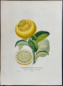
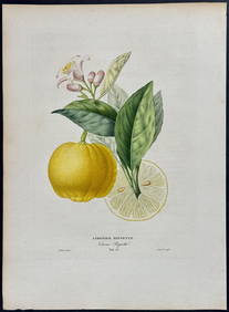
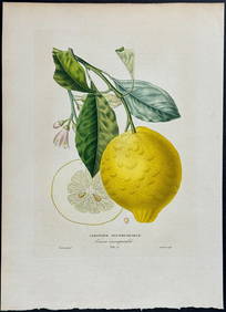
Risso - Lemon or Citrus Fruit. 73Trillium Antique Prints & Rare Books4.5(28)See Sold PriceFeb 24, 2024
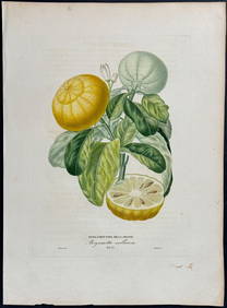
Risso - Lemon or Citrus Fruit. 71Trillium Antique Prints & Rare Books4.5(28)See Sold PriceFeb 24, 2024
Robert Benard (1734 - 1777) - Set of 9 Copperplate Engravings - Greek and Roman architecture - ViewProverde Auctions4.3(3)See Sold PriceFeb 28, 2024
Robert Benard (1734 - 1777) - Set of 9 Copperplate Engravings - Architecture, Masonry, Quarry withProverde Auctions4.3(3)See Sold PriceFeb 28, 2024
Robert Benard (1734 - 1777) - Set of 9 Chemical Engravings - Alchemical symbols - Utensils forProverde Auctions4.3(3)See Sold PriceFeb 28, 2024
Denis Diderot (1713 - 1784) & Jean Le Rond d’Alembert (1717 - 1783) - Set of 10 Military Prints -Proverde Auctions4.3(3)See Sold PriceFeb 28, 2024
Jules Verne, De La Terre a La Lune, Au Steamer Red MacaronLion and Unicorn4.8(1.8k)See Sold PriceMar 10, 2024
Jules Verne, L'Archipel en Feu, Au Steamer Red MacaronLion and Unicorn4.8(1.8k)See Sold PriceMar 10, 2024
Herman Moll A New Map of Ye North Parts of AmericaWillow Auction House4.5(280)See Sold PriceMar 14, 2024