A handtinted coloured map of Northamptonshire by JohnA handtinted coloured map of Northamptonshire by John Speed c1611, 51 x 39cm.See Sold Price
SoldA hand tinted and coloured map of Herefordshire by JohnA hand tinted and coloured map of Herefordshire by John Speed c1627, 51 x 41cm, slightly AF to centrefold.See Sold Price
SoldA handtinted coloured map of Huntingdon ' both ShireA handtinted coloured map of Huntingdon ' both Shire and Shire Town with The Ancient Citie, Ely' described by John Speed c1627. 51 x 38cm.See Sold Price
SoldA handtinted, coloured map of Buckingham ' both ShyreA handtinted, coloured map of Buckingham ' both Shyre and Shyretowne' described by John Speed, 52 x 40cm.See Sold Price
SoldCary (John) New and Correct Atlas: Being a New SetCary (John) New and Correct Atlas: Being a New Set of County Maps,engraved title and 47 hand-coloured maps, Northamptonshire with notes and additional lines in purple pencil, a couple of otherSee Sold Price
SoldAn engraved and hand coloured map of Northamptonshire,An engraved and hand coloured map of Northamptonshire, by Robert Morden, titled within a decorative cartouche, top right. Published by Abel Swale, Awnsham and John Churchill. Approx. 14 1/4'' x 16 1/2See Sold Price
SoldAn engraved and hand coloured map of Northamptonshire,An engraved and hand coloured map of Northamptonshire, by Robert Morden, titled within a decorative cartouche, top right. Published by Abel Swale, Awnsham and John Churchill. Approx. 14 1/4'' x 16 1/2See Sold Price
SoldAn engraved and hand coloured map of Northamptonshire,An engraved and hand coloured map of Northamptonshire, by Robert Morden, titled within a decorative cartouche, top right. Published by Abel Swale, Awnsham and John Churchill. Approx. 14 1/4'' x 16 1/2See Sold Price
SoldA 19thC hand coloured and tinted map ofA 19thC hand coloured and tinted map of Northamptonshire and similar map of Oxfordshire. Also six other 19thC handtinted maps. Eight items in total.See Sold Price
SoldJohn Cary, engraver, map of Northamptonshire, handJohn Cary, engraver, map of Northamptonshire, hand coloured, published 1809. 23x28cm.See Sold Price
A New Map of Northamptonshire, divided into hundreds,A New Map of Northamptonshire, divided into hundreds, by John Cary, dated 1811, coloured engraving, 51x55cm, together with another similar of Buckinghamshire and a map of Bedfordshire by Piggot & Co.See Sold Price
SoldJohn Cary, engraver, map of Northamptonshire from theJohn Cary, engraver, map of Northamptonshire from the best authorities, published 1805, hand coloured. 43x48cm.See Sold Price
Robert Morden - Map of Northampton Shire, sold by AbelRobert Morden - Map of Northampton Shire, sold by Abel Swale Awnsham and John Churchill, hand coloured, 42.5 x 36cm approxSee Sold Price
SoldA handtinted coloured map of Huntingdonshire by J.A handtinted coloured map of Huntingdonshire by J. Blaeu c1746, 53 x 42cm.See Sold Price
A handtinted coloured map of Scotland by Robert MordenA handtinted coloured map of Scotland by Robert Morden c1695, 43 x 35cm.See Sold Price
A handtinted coloured map of Scotland dated 1752, 57 xA handtinted coloured map of Scotland dated 1752, 57 x 47cm.See Sold Price
SoldA handtinted coloured map of Stafford 'Countie andA handtinted coloured map of Stafford 'Countie and Towne with the Ancient Citie Litchfield' described c1627, slightly AF to centrefold, 51 x 38cm.See Sold Price
SoldA handtinted coloured map of Wales and South WestA handtinted coloured map of Wales and South West England by F.de Wit, (P. Mortier) c1684, 50 x 58cm.See Sold Price
SoldTwo framed and glazed hand coloured mapsTwo framed and glazed hand coloured maps; John Speed, detailed 'Shropshire, described the situation of Shrowsbury Shrewed, with the arm of Thos earlies and other memorable things observed', 15.25" x 2See Sold Price
SoldA handtinted and coloured map of 'Glocestraiae' byA handtinted and coloured map of 'Glocestraiae' by Christopher Saxton c1610, 29 x 31cmSee Sold Price
SoldA handtinted coloured strip map, 'The road from ExeterA handtinted coloured strip map, 'The road from Exeter to Truroe' by J. Ogleby c1679, 34 x 45cmSee Sold Price
SoldAtlases.- Teesdale (Henry) A New General Atlas of theAtlases.- Teesdale (Henry, publisher) A New General Atlas of the World, engraved vignette title and 46 hand-coloured maps by John Dower, India double-page (numbered 26 & 27) and mounted on stub (splitSee Sold Price
Unusual Victorian Hand Coloured Map of England JohnUnusual Victorian Hand Coloured Map of England John Heywood A unique Victorian map of England and Wales which appears to have been filled by the hand of an amateur cartographer. The bottom of the mapSee Sold Price
A handtinted, part coloured New map of England andA handtinted, part coloured New map of England and Wales divided into it's Counties... by Thomas Kitchen, c1764, 40 x 49cm.See Sold Price
Numismatic Books - Lelewel - Numismatique du Moyen-AgeTimeLine Auctions Ltd.4.6(184)See Sold PriceMar 09, 2024
JANSSONS - A COLOURED MAP OF THE COUNTY OF WETMORLANDHutchinson Scott Auctioneers4.4(42)See Sold PriceFeb 28, 2024
A 19TH CENTURY HAND COLOURED MAP OF ORKNEY AND SHETLANDHutchinson Scott Auctioneers4.4(42)See Sold PriceFeb 28, 2024
Map: An 18thC engraved and hand coloured map of Buckinghamshire after Robert Morden. Approx. 8 1/4"Claydon Auctioneers Ltd4.3(125)See Sold PriceFeb 26, 2024
Map: A 19thC engraved and hand coloured map of South America. Published by the Society for theClaydon Auctioneers Ltd4.3(125)See Sold PriceFeb 26, 2024
Map: An 18thC engraved and hand coloured map of Northamptonshire, with description ofClaydon Auctioneers Ltd4.3(125)See Sold PriceFeb 26, 2024
Map: A 19thC engraved and hand coloured map of St. Petersburg / Sanktpeterburga by W. B. Clarke.Claydon Auctioneers Ltd4.3(125)See Sold PriceFeb 26, 2024
Map: A 17thC engraved and hand coloured map of Scotland titled Strath-Navernia / Strath Navern afterClaydon Auctioneers Ltd4.3(125)See Sold PriceFeb 26, 2024
Map: An engraved and hand coloured map titled The Countie of Nottingham described The Shire TownesClaydon Auctioneers Ltd4.3(125)See Sold PriceFeb 26, 2024
Map: A 17thC engraved and hand coloured map of Bedfordshire after Robert Morden. Approx. 12 1/2" xClaydon Auctioneers Ltd4.3(125)See Sold PriceFeb 26, 2024
Map: An 18thC engraved and hand coloured map of North America and South America, titled DeClaydon Auctioneers Ltd4.3(125)See Sold PriceFeb 26, 2024
Map: A 19thC engraved and hand coloured map of Buckingham titled A New Map of BuckinghamshireClaydon Auctioneers Ltd4.3(125)See Sold PriceFeb 26, 2024
Map: A 17thC engraved and hand coloured map after Frederik de Wit (1630-1706) titled Nova Persiae,Claydon Auctioneers Ltd4.3(125)See Sold PriceFeb 26, 2024
Ireland.- Smedley (Edward) Erin. A Georgraphical and Descriptive Poem, 2 parts in 1, first edition,Forum Auctions4.4(54)See Sold PriceFeb 29, 2024
Railways & Transport.- [Prospectus] The Dorking, Brighton, and Arundel Atmospheric Railway, byForum Auctions4.4(54)See Sold PriceFeb 29, 2024
Morocco, Algeria, Tunisia & Libya. North Africa. HUGHES 1876 old antique mapJasper524.5(9.9k)See Sold PriceFeb 28, 2024
CENTRAL EAST AFRICA French Belgian Congo British German Kenya Tanzania 1909 mapJasper524.5(9.9k)See Sold PriceFeb 28, 2024
Africa. French Equatorial Africa. Rhodesia. Belgian Congo. TIMES 1956 old mapJasper524.5(9.9k)See Sold PriceFeb 28, 2024
Morocco Algeria. French & Spanish West Africa. Sahara sand dunes. TIMES 1956 mapJasper524.5(9.9k)See Sold PriceFeb 28, 2024
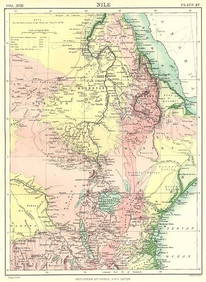
NILE VALLEY. Sudan Tanzania Ethiopia Uganda Lake Victoria. Britannica. 1898 mapJasper524.5(9.9k)See Sold PriceFeb 28, 2024
Central & East Africa. Zanzibar Tanganyika Rhodesia Congo. TIMES 1956 old mapJasper524.5(9.9k)See Sold PriceFeb 28, 2024
AFRICA. Africa. Britannica 9th edition 1898 old antique vintage map plan chartJasper524.5(9.9k)See Sold PriceFeb 28, 2024
French West Africa. Gold Coast. Sahara desert sand dunes. TIMES 1956 mapJasper524.5(9.9k)See Sold PriceFeb 28, 2024


![Railways & Transport.- [Prospectus] The Dorking, Brighton, and Arundel Atmospheric Railway, by (1 of 1)](https://p1.liveauctioneers.com/5458/319736/171654703_1_x.jpg?height=282&quality=70&version=1708010439)