Folding travel map of Japan 1881Heading: (Japan) Author: Otani, Gennosuke Title: Shinpan Daiji Dainihon ezu: zen (Newly printed Map of Japan with large letters [labels] - complete) ([Recommended journey through Japan]) Place PublishSee Sold Price
SoldFolding travel map of Japan 1881Heading: (Japan) Author: Otani, Gennosuke Title: Shinpan Daiji Dainihon ezu: zen (Newly printed Map of Japan with large letters [labels] - complete) ([Recommended journey through Japan]) Place PublishSee Sold Price
SoldIsabella Bird, Unbeaten Tracks in Japan, 1st, 1881A first edition book, Unbeaten Tracks in Japan, an account of travels on horseback in the interior, by Isabella L. Bird (1831-1904). Two volumes in one book. with folding map and illustrations. PublisSee Sold Price
Sold6 Vols incl: UNBEATEN TRACKS IN JAPAN. 1881.[Asia/Japan] 5 Titles (6 Vols). 8vo. ++ Isabella L. Bird. UNBEATEN TRACKS IN JAPAN: An Account of Travels on Horseback in the Interior… 2 Vols. NY: G. P. Putnam’s Sons, 1881. Orig cloth. Spines faSee Sold Price
Antique Folding Map of the New York Railroad, 1881Title/Content of Map: 1881 Folding Map of the New York Central and Hudson River Railroad -- New-York Central and Hudson River Rail Road and Its Connections Date Printed: 1881 Buffalo Cartographer: MatSee Sold Price
1881 Folding Map of NY Central Hudson River RailroadTitle/Content of Map: 1881 Folding Map of the New York Central and Hudson River Railroad -- New-York Central and Hudson River Rail Road and Its Connections Date Printed: 1881 Buffalo Cartographer: MatSee Sold Price
1881 Folding Map of the New York Central and HudsonTitle/Content of Map: 1881 Folding Map of the New York Central and Hudson River Railroad --New-York Central and Hudson River Rail Road and Its Connections Date: 1881 Buffalo Cartographer: Matthews, NoSee Sold Price
1881 Folding Map of the New York Central and HudsonTitle/Content of Map: 1881 Folding Map of the New York Central and Hudson River Railroad -- New-York Central and Hudson River Rail Road and Its Connections Date: 1881 Buffalo Cartographer: Matthews, NSee Sold Price
1881 Folding Map of the New York Central and HudsonTitle/Content of Map: 1881 Folding Map of the New York Central and Hudson River Railroad -- New-York Central and Hudson River Rail Road and Its Connections Date: 1881 Buffalo Cartographer: Matthews, NSee Sold Price
1881 Folding Map of the New York Central and HudsonTitle/Content of Map: 1881 Folding Map of the New York Central and Hudson River Railroad -- New-York Central and Hudson River Rail Road and Its Connections Date: 1881 Buffalo Cartographer: Matthews, NSee Sold Price
1881 Folding Map of the New York Central and HudsonTitle/Content of Map: 1881 Folding Map of the New York Central and Hudson River Railroad -- New-York Central and Hudson River Rail Road and Its Connections Date: 1881 Buffalo Cartographer: Matthews, NSee Sold Price
1881 Folding Map of the New York Central and HudsonTitle/Content of Map: 1881 Folding Map of the New York Central and Hudson River Railroad --New-York Central and Hudson River Rail Road and Its Connections Date: 1881 Buffalo Cartographer: Matthews, NoSee Sold Price
SoldMulhall Between the Amazon and AndesMulhall (Mrs. M.G.) Between the Amazon and Andes, or Ten Years of a Lady's Travels, first edition, 2 folding maps, 1 little torn, frontispiece, 8 plates, 1881 ? Mathews (Edward D.) Up the AmazSee Sold Price
Sold5pc Early 20th Century Folding Maps of China.5pc Early 20th Century Folding Maps of China. Philips and W. & A.K. Johnston. 1898-1935. Includes 4pc Philips Maps- Daily Mail Commercial Map of China (1898), Chinese Empire and Japan (1900), 'China'See Sold Price
Antique Meiji Period Folding Map of Japan, 1893Title/Content of Map: 1893 Meiji Period Folding Map of Japan, legends in English/Japanese -- Japan Date Printed: 1,893 Cartographer: Anonymous Size: 65 x 61.8 in. map and 10.9 x 7.9 in. case. This isSee Sold Price
Sold3pc Stanford Folding Maps & Index. 1896-19283pc Edward Stanford Folding Maps & Index. Includes 'Empires of China and Japan' Folding Map, 1896 (dissected and laid down on linen backing 26.5x40.5''), 'A Map of China Prepared for the Inland MissioSee Sold Price
SoldJapan.- Fugestu (Shozaemon) Kyoto ku kumiwake saizuJapan.- Fugestu (Shozaemon) Kyoto ku kumiwake saizu [Map of Kyoto Prefecture], colour printed woodcut, on thin japan, sheet 475 x 720 mm (18 3/4 x 28 1/4 in), folding with original yellow endpapers wiSee Sold Price
Antique Meiji Period Folding Map of Japan, 1893Map: 1893 Meiji Period Folding Map of Japan, legends in English/Japanese -- Japan Cartographer: Anonymous Year / Place: 1893 Dimensions: 65 x 61.8 in. map and 10.9 x 7.9 in. case. Condition: Overall GSee Sold Price
SoldMemorials of the Empire of Japon with folding map 1850Heading: (Japan) Author: Rundall, Thomas, editor Title: Memorials of the Empire of Japon: In the XVI and XVII Centuries. Place Published: London Publisher:Hakluyt Society Date Published: 1850See Sold Price
Sold1881 Folding Map of the New York Central and HudsonTitle: 1881 Folding Map of the New York Central and Hudson River Railroad -- New-York Central and Hudson River Rail Road and Its Connections Cartographer: Matthews, Northrup Co. Year / Place: 1881 BufSee Sold Price
SoldGeneral Map of Eastern Asia'. China Japan PhilippinesTITLE/CONTENT OF MAP: 'General Map of Eastern Asia' DATE PRINTED: 1913 IMAGE SIZE: Approx 72.0 x 49.0cm, 28.25 x 19.25 inches (Large); Please note that this is a folding map. TYPE: Antique colour mapSee Sold Price
Plan de Jedo'. Tokyo antique town city plan. Japan.TITLE/CONTENT OF MAP: 'Plan de Jedo, A.Palais de l'Empereur B.Niponbas ou le pont de l'Empereur [Plan of Tokyo]' This map is folding hence the centrefold line may show on the image below DATE PRINTED:See Sold Price
1893 Meiji Period Folding Map of Japan, legends in1893 Meiji Period Folding Map of Japan, legends in English/Japanese -- Japan 1893 Anonymous 65 x 61.8 in. map and 10.9 x 7.9 in. case. This is a fantastic, highly detailed, very large and rare map ofSee Sold Price
SoldMemorials of the Empire of Japon with folding map 1850Heading: (Japan) Author: Rundall, Thomas, editor Title: Memorials of the Empire of Japon: In the XVI and XVII Centuries. Place Published: London Publisher:Hakluyt Society Date Published: 1850See Sold Price
RUSSIAN ORTHODOX GILT BRONZE FOLDING TRAVEL ICONAustin Auction Gallery4.7(1.2k)See Sold PriceFeb 25, 2024
AN ANTIQUE FOLDING MAP OF THE BRITISH ISLES DATED 1873Hutchinson Scott Auctioneers4.4(39)See Sold PriceFeb 28, 2024
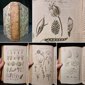
1797 Universal Magazine BOTANY PLATES Flowers FRUIT 12 Copper Engraved PlatesPrivate NY Collection4.2(21)See Sold PriceMar 01, 2024
1800 MUNGO PARK TRAVELS to AFRICA 2 VOLS w/ MAP antique in ENGLISHJasper524.5(9.7k)See Sold PriceFeb 27, 2024
1790 AFRICA TRAVELS Voyages dans le pays des Hottentots ILLUSTRATED antique RAREJasper524.5(9.7k)See Sold PriceFeb 27, 2024
South Namibia coast. Walvis Bay-Orange River ADMIRALTY sea chart 1881 (1954) mapJasper524.5(9.7k)See Sold PriceFeb 28, 2024
ANTIQUE ILLUSTRATED HANDBOOK OF GEOGRAPHY AND TRAVEL IN ASIA, VOLUME 2, 1896NY Elizabeth 4.3(83)See Sold PriceMar 03, 2024