ATLAS of ANTIENT GEOGRAPHY by SAMUEL BUTLER 1843John McInnis Auctioneers,LLC4.5(505)See Sold PriceFeb 24, 2024
18TH C. ANTIQUE MAP: FRENCH & INDIAN WAR, FRAMEDThomaston Place Auction Galleries4.4(393)See Sold PriceFeb 24, 2024
Rand McNally Railroad Map Cabinet w/ 21 Railroad MapsRail & Road Auctions4.6(165)See Sold PriceMar 08, 2024
Keith Haring - Ink on New York Map, Best Buddies, Inscribed, Signed, and DatedSapphire Auction Gallery4(67)See Sold PriceMar 02, 2024
LATE 17TH C. FRENCH MAP OF THE NEW WORLD BY ALEXIS-HUBERT JAILLOT (1632-1712)Thomaston Place Auction Galleries4.4(393)See Sold PriceFeb 24, 2024
Central Railroad of New Jersey Map of Sandy Hook Route-ca. 1903JM Hobby Supply and Railroad Artifact Auctions4.4(127)See Sold PriceFeb 24, 2024
Lot of Six Mixed Atlas Box Cars-HO Scale-New in BoxJM Hobby Supply and Railroad Artifact Auctions4.4(127)See Sold PriceFeb 25, 2024
Rand McNally/Santa Fe Railroad Map of Iowa-1912JM Hobby Supply and Railroad Artifact Auctions4.4(127)See Sold PriceFeb 24, 2024
NICOLAES VISSCHER (NETHERLANDS, 1618-1709) MAP OF THE NEW WORLDThomaston Place Auction Galleries4.4(393)See Sold PriceFeb 24, 2024
17TH C. WORLD MAP BY NICOLAES VISSCHER (NETHERLANDS, 1618-1709)Thomaston Place Auction Galleries4.4(393)See Sold PriceFeb 24, 2024
Lot of Six Mixed Atlas Cabooses-HO Scale-New in BoxJM Hobby Supply and Railroad Artifact Auctions4.4(127)See Sold PriceFeb 25, 2024
Sold3pc Stanford Folding Maps & Index. 1896-19283pc Edward Stanford Folding Maps & Index. Includes 'Empires of China and Japan' Folding Map, 1896 (dissected and laid down on linen backing 26.5x40.5''), 'A Map of China Prepared for the Inland MissioSee Sold Price
Central Asia. Trans-Caspian Aral Sea Khiva Bokhara Sirdaria STANFORD 1896 mapTITLE/CONTENT OF MAP: 'Central Asia' DATE PRINTED: 1896 IMAGE SIZE: Approx 36.0 x 50.0cm, 14 x 19.75 inches (Large); Please note that this is a folding map. TYPE: Large (folio) antique atlas map CONDISee Sold Price
Dutch & British North Borneo Sarawak Kalimantan Palawan. STANFORD 1896 old mapCAPTION PRINTED BELOW PICTURE: 'Borneo' DATE PRINTED: 1896 IMAGE SIZE: Approx 63.5 x 44.0cm, 25 x 17.5 inches (Large); Please note that this is a folding map. TYPE: Large (folio) antique atlas map CONSee Sold Price
ASIA Japanese Formosa British India Siam Oman Abu Debi (Dhabi) STANFORD 1896 mapCAPTION PRINTED BELOW PICTURE: 'Asia' DATE PRINTED: 1896 IMAGE SIZE: Approx 51.5 x 64.5cm, 20.25 x 25.25 inches (Large); Please note that this is a folding map. TYPE: Large (folio) antique atlas map CSee Sold Price
BALKAN PENINSULA Greece Austria Rumili Servia Turkey Romania STANFORD 1896 mapTITLE/CONTENT OF MAP: 'The states & provinces of the Balkan Peninsula' DATE PRINTED: 1896 IMAGE SIZE: Approx 63.5 x 49.5cm, 25 x 19.5 inches (Large); Please note that this is a folding map. TYPE: LargSee Sold Price
BALKAN PENINSULA Greece Austria Rumili Servia Turkey Romania STANFORD 1896 mapTITLE/CONTENT OF MAP: 'The states & provinces of the Balkan Peninsula' DATE PRINTED: 1896 IMAGE SIZE: Approx 63.5 x 49.5cm, 25 x 19.5 inches (Large); Please note that this is a folding map. TYPE: LargSee Sold Price
Central Asia. Trans-Caspian Aral Sea Khiva Bokhara Sirdaria STANFORD 1896 mapTITLE/CONTENT OF MAP: 'Central Asia' DATE PRINTED: 1896 IMAGE SIZE: Approx 36.0 x 50.0cm, 14 x 19.75 inches (Large); Please note that this is a folding map. TYPE: Large (folio) antique atlas map CONDISee Sold Price
SoldEARLY NEW ENGLAND DIRECTORIES AND GAZETEERS, 1896EARLY NEW ENGLAND DIRECTORIES AND GAZETEERS, 1896 NEW BRITON DIRECTORY, 1876 HARTFORD DIRECTORY W/FOLDING MAP, 1928 KEENE NEW HAMPSHIRE DIRECTORY, 1885 CHESHIRE COUNTY NEW HAMPSHIRE GAZETEER BY HAMILTSee Sold Price
SoldStanford (Edward) - Stanford's Library Map of Londonlarge folding engraved map in 4 parts, each dissected and linnen-backed, hand-coloured in outline, light finger soiling and dusting, blue and gold paper covers with index map labels, each sheet measurSee Sold Price
Stanford: Antique Map Of Central Asia, 1896TITLE/CONTENT OF MAP: 'Central Asia' Trans-Caspian Aral Sea Khiva Bokhara Sirdaria DATE PRINTED: 1896 IMAGE SIZE: Approx 36.0 x 50.0cm, 14 x 19.75 inches (Large); Please note that this is a folding maSee Sold Price
History of Long Island by Benjamin F. ThompsonHistory of Long Island by Benjamin F. Thompson. Limited third edition. Royal octavo. xxiv + 451, 441, 479, 483 pp; 45 gravure plates and 2 folding maps; index. Cloth with gilt spine titles and deckleSee Sold Price
Middle East.- Philby (Harry St John Bridger) Arabia ofMiddle East.- Philby (Harry St John Bridger) Arabia of the Wahhabis, folding map, 1928; The Empty Quarter, 2 folding maps, ex-library with stamps to title, bookplate to pastedown and shelf marking toSee Sold Price
Sold[Geography] Strabonis de situ Orbis, 1652Strabo. STRABONIS DE SITU ORBIS LIBRI XVII.... Amsterdam: Apud Joannem Janssonium Juniorem, 1652. 5" x 2.75". 2 volumes bound in 3. Engraved title-leaf in each volume, plus folding map, index in finalSee Sold Price
The Northern Barrier Of India Book – A...The Northern Barrier Of India Book – A Popular Account Of The Jummoo And Kashmir Territories By Frederic Drew, London: Edward Stanford, folding Map to rear, many illustrations which include 3 originSee Sold Price
1842 Missionary Labours and Scenes in Southern AfricaLondon: John Snow, 1842. First edition, fifth thousand. Hand colored frontispiece, engraved title page with vignette and 20 engravings, folding map, index. Three quarter leather with marbled boards anSee Sold Price
Sold(Maps and Charts, Great Britain), Whitebread's New(Maps and Charts, Great Britain), Whitebread's New Plan of London extending Four Miles from Charing Cross, c. 1866, folding map with Index, hand-colored accenting, on linen, folding into pebbled clothSee Sold Price
Stanford, Edward Map of the Seat of War in the Far EastStanford, Edward Map of the Seat of War in the Far East London: Edward Stanford, 1904, folding map in maroon cloth covers with paper label to upper cover, 114 x 83cm, stamps of Manchester Public LibraSee Sold Price
SoldCreswell (K.A.C.) - The Mosques of Egypt,2 vol., facsimile edition, no. 511 of 1200 copies, numerous plates and illustrations (many printed in colour with tissue guards), 2 folding maps and Index in pocket at end of the first vol., originalSee Sold Price
SoldScott-Elliot (G.F.) The Flora of DumfriesshireScott-Elliot (G.F.) The Flora of Dumfriesshire,2 copies, folding map, Dumfries, 1896 (15)See Sold Price
India North Western Frontier Kashmir Pamir region Afghanistan. STANFORD 1896 mapCAPTION PRINTED BELOW PICTURE: 'Map of the North Western Frontier of India showing the Pamir region and part of Afghanistan' DATE PRINTED: 1896 IMAGE SIZE: Approx 48.5 x 67.5cm, 19 x 26.5 inches (LargSee Sold Price
Indo-China. Indochina. Siam Annam Burma Thailand Cambodia. STANFORD 1896 mapCAPTION PRINTED BELOW PICTURE: 'Siam, Burma & Anam' DATE PRINTED: 1896 IMAGE SIZE: Approx 52.0 x 36.5cm, 20.5 x 14.25 inches (Large) TYPE: Large (folio) antique atlas map CONDITION: Good; suitable forSee Sold Price
Central Asia. Trans-Caspian Aral Sea Khiva Bokhara Sirdaria STANFORD 1896 mapCAPTION PRINTED BELOW PICTURE: 'Central Asia' DATE PRINTED: 1896 IMAGE SIZE: Approx 35.5 x 50.5cm, 14 x 20 inches (Large) TYPE: Large (folio) antique atlas map CONDITION: Good; suitable for framing. TSee Sold Price
India North Western Frontier Kashmir Pamir region Afghanistan. STANFORD 1896 mapTITLE/CONTENT OF MAP: 'Map of the North Western Frontier of India showing the Pamir region and part of Afghanistan' DATE PRINTED: 1896 IMAGE SIZE: Approx 50.5 x 68.5cm, 20 x 27 inches (Large); PleaseSee Sold Price
Stanford (Edward) 3 folding maps of DevonshireStanford (Edward) 3 folding maps of Devonshire,showing Kilmington, Axminster, Marshwood Vale, Axmouth, and part of the coastline on the English Channel, lithographs, with some outline hand-colSee Sold Price
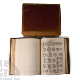
Numismatic Books - Rudding's Coinage of Britain Vol I-III, Plus SuplementTimeLine Auctions Ltd.4.6(183)See Sold PriceMar 09, 2024
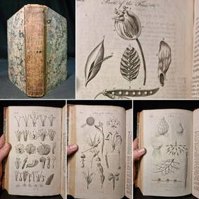
1797 Universal Magazine BOTANY PLATES Flowers FRUIT 12 Copper Engraved PlatesPrivate NY Collection4.2(22)See Sold PriceMar 01, 2024
1749-1771 HISTORY OF ROMAN EMPERORS 12 VOLUMES antique ILLUSTRATED w/ MAPSJasper524.5(9.9k)See Sold PriceFeb 27, 2024
1675 ELZEVIER JULIUS CAESAR antique ILLUSTRATED w/ MAPS ROMAN HISTORYJasper524.5(9.9k)See Sold PriceFeb 27, 2024
1749-59 21 volumes NETHERLANDS HISTORY ILLUSTRATED antique VELLUM BOUNDJasper524.5(9.9k)See Sold PriceFeb 27, 2024
Kent & Sussex.- Moss (W.G.) The History and Antiquities of the Town and Port of Hastings, 1824; andForum Auctions4.3(53)See Sold PriceFeb 29, 2024
Africa. Congo Free Trade Area. British South Africa Company. STANFORD 1896 mapJasper524.5(9.9k)See Sold PriceFeb 28, 2024
Northwest Africa. Morocco Sahara Rio do Oro Ain Sefra Gardaia. STANFORD 1904 mapJasper524.5(9.9k)See Sold PriceFeb 28, 2024
Central Africa. Congo Free State Rhodesia German East Africa. STANFORD 1896 mapJasper524.5(9.9k)See Sold PriceFeb 28, 2024
Gulf of Guinea. Ghana Togo Benin Nigeria. ADMIRALTY sea chart 1928 (1954) mapJasper524.5(9.9k)See Sold PriceFeb 28, 2024
Africa. Congo Free Trade Area. British South Africa Company. STANFORD 1894 mapJasper524.5(9.9k)See Sold PriceFeb 28, 2024
Northwest Africa. Morocco Sahara Rio do Oro Ain Sefra Gardaia. STANFORD 1904 mapJasper524.5(9.9k)See Sold PriceFeb 28, 2024
ANTIQUE ILLUSTRATED HANDBOOK OF GEOGRAPHY AND TRAVEL IN ASIA, VOLUME 2, 1896NY Elizabeth 4.2(86)See Sold PriceMar 03, 2024
1675: ANTIQUE ILLUSTRATED JULIUS CAESAR MAPS OF ROMAN HISTORYNY Elizabeth 4.2(86)See Sold PriceMar 03, 2024


![[Geography] Strabonis de situ Orbis, 1652 (1 of 7)](https://p1.liveauctioneers.com/3532/95081/48483477_1_x.jpg?height=282&quality=70&version=1476656219)