SoldGrp: 12 Regional Maps of AfricaGroup of twelve 18th and 19th c. regional maps of Africa. Includes two maps of the North African coast; one map of Madagascar; one page with seven inset maps of the major islands of Africa; one map ofSee Sold Price
SoldFrench map of Africa, probably 19th c. 17.5'x22.25French map of Africa, probably 19th c. 17.5'x22.25See Sold Price
Sold(3) MAPS OF AFRICA, LIMA and EAST INDIESAfrica is dated 1748, each by Eman Bowen and separated from their atlas. 16 x 21 inches on laid paper. Together with a "Plan of Lima" 16 x 10 1/4 inches on modern (19th c) laid paper.See Sold Price
SoldEarly 19th Century Map of Africa Published by C. Smith Federal period map of Africa, English, 1808. Printed Eng. By E. Jones. London Published by C. Smith No. 172 Strand Jan 6 1808 along lower edge. 20.75 x 17.5 inches.See Sold Price
Sold19th C Henry M. Stanley Illustrated Africa Series19th C Antique Henry M. Stanley illustrated Africa Series: "Through the Darkest Continent " Volumes I & II (1878) leather binding & "In Darkest Africa" (1891) Volumes I & II cloth binding. Largest booSee Sold Price
Sold(3) 19TH C. ASIAN / MELANESIAN SEA CHARTSIncluding: "Indian Ocean", London, Published by James Imray and Son, 1877. Blue paper backed engraving on wove paper, Japanese cloth edging, showing from east coast of Africa to Australia, 41" x 75",See Sold Price
Sold19thc In Darkest Africa, Volume I, Henry Stanley1890 edition, Volume I, "In Darkest Africa" by Henry M. Stanley. 546 pages, 17 full page illustrations, 54 smaller illustrations throughout. * age related wear to spine. handwriting on interior coverSee Sold Price
SoldVarious. 28 maps of Africa. c.19th century.[Africa] 28 maps. Various maps of Africa mostly 19th century. (1) Lapie. “Afrique Ancienne.” 1812. (2) Johnston. “Egypt and Arabia Petraea.” c.1850. (3) Harrison. “EgyptSee Sold Price
Sold(4) 19th c. Maps and Guides to New York CityIncluding (2) "'The Great Metropolis or New York in 945" by John Dogget. New York. Hardcover mottled cloth-bound, gilt and blind stamped. (fading, minor wear to covers, toning) 5 1/2 x 3 1/2 inches eaSee Sold Price
Sold(16) 19TH C. MAPS OF THE WEST INDIES IN FOLIO,Including: "L'Isle de Ste. Domingue, et celle de Porto Rico", by Bonne, hand colored engraving,1778, 10" x 14 1/2"; PLUS "West Indies", Smith's Atlas, 1808, hand colored engraving, 1808, 11" x 14"; PLSee Sold Price
Sold19TH C MAP OF FRANCE BEFORE THE REVOLUTIONAntique Map of France before the Revolution divided into Military Governments engraved for J. Bradley's Elements of Geography. Professionally framed and triple matte, silk mat. In frame 17 1/2"x16"x1"See Sold Price
SoldTwo 19th C. MapsTwo framed 19th C. maps: the United States; Mexico/California/Texas. Various dates and publishers.See Sold Price
Sold19th c. Map of Virginia and Maryland2 19th c. maps of US states 1). Map of Virginia and Maryland with a plan of Washington and Georgetown. 2). Map of Kentucky and Tennessee- both copper engravings, published in London in 1831 by Isaac TSee Sold Price
Sold19TH C. MAP OF MASSACHUSETTS, CONNECTICUT ANDPUBLISHED BY SUMNER & CO. 1833 MAP IS 19" X 15". BOOK IS 3" X 5"See Sold Price
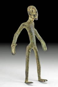
Sold19th C. Africa 6 Bronze Items - Antiquarian CollectionCentral Africa, 19th century CE. This is a collection of six bronze items, all with presentation numbers penned in ink and a photocopy of the original typed card that accompanied them. There are two tSee Sold Price
Sold(2) Late 19th c. maps of Ireland, unframedTwo late 19th century colored maps of Ireland, comprising a map of Ireland printed for The Century Atlas, circa 1897, 16"h x 11"w, unframed, and a map of Ireland printed for The Society for the DiffusSee Sold Price
19th C Map of HindoostanMap: Hindoostan (India) Date: 19th century Map Size: 10 x 12 inches Frame Size: 18 x 20 inches Hindoostan (or Hindustan) is a common geographic term for the northern/northwestern Indian subcontinent.See Sold Price
SoldLOT OF 6 19TH C MAPS POLYCHROMED CELESTIAL C.1880A grouping of six nineteenth Century maps to include a nicely polychromed celestial map having cherub surround circa 1880. Ht: 24" Width: 27" Depth: 1"See Sold Price
SoldNine Colored 19th c. Maps, Framed and MattedNine framed and matted colored maps, 19th c., each approximately 16"h x 16"wSee Sold Price
SoldA Group Of 17-18 & 19th C Maps Hand Colored EngravedA Group Of 17-18 & 19th C Maps Hand Colored Engraved. These Are Affixed To A Screen Or Divider. 17 & 18th C Maps Are Hand-colored And Etched or Engraved. The 19th C Maps Are Rand McNally. Please ViewSee Sold Price
Sold19TH C. MAP OF PARIS19TH C. MAP OF PARIS: Large framed map of Paris Circa Mid 1900's by Malte-Brun family, in frame. Approx. 35" h x 43" w.See Sold Price
SoldFour 19th C. Maps of the United StatesLot of four mid/late 19th C. maps of the United States. Various dates and publishers.See Sold Price
SoldCOLLECTION OF 4 LATE 19TH C MAPS AND 2 ENGRAVINGSINCLUDING 2 LARGE MAPS OF MIDDLEBOROUGH; 1 OF FREETOWN; 2 OF LAKEVILLE AND 2 ENGRAVINGS OF MIDDLEBOROUGH; SOME STAININGSee Sold Price
19thc Colton Map, Comparitive Size of Lakes & IslandsConnoisseur Auctions4(333)See Sold PriceFeb 24, 2024
(13) 19th C. Prints Great Homes of Britain PrintsEpic Auctions and Estate Sales4.6(204)See Sold PriceMar 02, 2024
Chinese Silk Brocade Shouxing Wall Hanging, 19th C.Material Culture4.6(765)See Sold PriceFeb 29, 2024
[POSTCARDS] Thirteen Better Black themed Postcards and Vari...Potter & Potter Auctions4.6(539)See Sold PriceMar 07, 2024
Map: A 19thC engraved and hand coloured map of South America. Published by the Society for theClaydon Auctioneers Ltd4.3(125)See Sold PriceFeb 26, 2024
Map: A 19thC engraved and hand coloured map of St. Petersburg / Sanktpeterburga by W. B. Clarke.Claydon Auctioneers Ltd4.3(125)See Sold PriceFeb 26, 2024
Map: A 19thC engraved map titled Gloucestershire from the Best Authorities, after John Cary. Approx.Claydon Auctioneers Ltd4.3(125)See Sold PriceFeb 26, 2024
Map: A 19thC engraved and hand coloured map of Buckingham titled A New Map of BuckinghamshireClaydon Auctioneers Ltd4.3(125)See Sold PriceFeb 26, 2024
Map: A 19thC engraved map of West Riding, titled A Map of the North Part of the West Riding ofClaydon Auctioneers Ltd4.3(125)See Sold PriceFeb 26, 2024
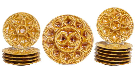
French Provincial Thirteen Piece Majolica Oyster Set, late 19th c., Plates- H.- 3/4 in., Dia.- 9 3/8Crescent City Auction Gallery4.3(229)See Sold PriceMar 08, 2024
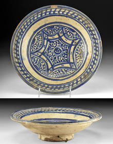
19th C. Moroccan Fez Cobalt Pottery Bowl, ex MuseumArtemis Fine Arts4.8(1.4k)See Sold PriceFeb 26, 2024
Rare 19thc Colton Map, Argentine Republic, Chile, Uruguay, PataguayConnoisseur Auctions4(333)See Sold PriceMar 16, 2024


![[POSTCARDS] Thirteen Better Black themed Postcards and Vari... (1 of 1)](https://p1.liveauctioneers.com/928/318880/171361153_1_x.jpg?height=282&quality=70&version=1707501302)