Sold4 Framed Antique Maps, 1758, Jacques-Nicolas Bellin:4 Framed Antique Maps, 1758, Jacques-Nicolas Bellin: Bellin (1703-1772) was 18 Years old when Appointed Chief Cartographer for French Navy. Four Maps from the "Le petit Atlas Francois Recueil de CarteSee Sold Price
Sold5 Framed Antique Maps, 1758, Jacques-Nicolas Bellin:5 Framed Antique Maps, 1758, Jacques-Nicolas Bellin: Bellin (1703-1772) as an Encyclopedist Contributed 944 Articles to the 1st Encyclopedia. 5 Maps from the "Le petit Atlas Francois Recueil de CartesSee Sold Price
Sold(2) ANTIQUE IRELAND MAPSCarte D' Irlande map published in 1867 by Alvin J. Johnson New York. Measures 10 3/4" x 15 3/4" (Framed 19 1/2" x 23 1/2") and a Jacques Nicolas Bellin A Chart of Ireland 1803 hand colored map. MeasurSee Sold Price
SoldPartie Occidentale de la Nouelle France ou du Canada.Jacques Nicolas Bellin. engraved map with original hand-color in outline. Nuremberg: Homann Heirs, 1755. 17 3/4 x 21 3/4 inches, 24 x 28 1/4 inches framed. Map Depicting French Territories Prior to thSee Sold Price
SoldBellin: Antique Map of Hudson Bay, 1770Map: Hudson Bay Date Printed: 1770 Cartographer: N. Bellin Material/Medium: Paper Size: 12 3/4" x 9 1/2" Rare Map. Printed in Paris. From the Atlas Portrait Jacques-Nicolas Bellin(1703-1772) was a FreSee Sold Price
SoldAN ANTIQUE MAP, "Carte des Variations de la Boussole,"AN ANTIQUE MAP, "Carte des Variations de la Boussole," PARIS, CIRCA 1765, engraving on paper, hydrographer Jacques Nicolas Bellin (1703-1772), plate: 36 1/4" x 23 1/4"; sheet: 25 5/8" x 37 1See Sold Price
SoldJACQUES NICOLAS BELLIN (FRANCE 1702-1873), MAP OFJACQUES NICOLAS BELLIN (FRANCE 1702-1873), MAP OF CHESAPEAKE BAY, 1ST EDITION, "CARTE DE LA BAYE DE CHESAPEACK ET PAYS VOISINS...", C.1757. SIGHT 8 1/4 X 12"; FRAMED AND GLAZED 12 X 15 3/4"See Sold Price
SoldCIRCA 1756 MAP OF LABRADOR BY J-N. BELLINJacques-Nicolas Bellin (1703-1772, French), Chief Cartographer to the French Navy, copper engraving, map of Labrador circa 1756, from a German Atlas, hand-coloured, framed, 8 1/4 x 11 1/2 inches.See Sold Price
Sold1757 MAP "CARTE DE LA NOUVELLE ANGLETERRE"Nouvelle Yorke, et Pensilvanie. Bellin, Jacques Nicolas. Includes eastern Pennsylvania along with New York and New England. 8 1/4 x 11 1/4 inches. framed 12 3/4 x 16 1/2 inches (overall)See Sold Price
SoldJacques Nicolas Bellin (French, 1703-1772)Jacques Nicolas Bellin (French, 1703-1772), "Carte de la Louisiane et des Pays Voisins...", 1755, engraved map, with outline color, sheet 21 1/4 in. x 26 1/2 in., framed; together with "A New Map of LSee Sold Price
Sold(MAP) BELLIN, JACQUES NICOLAS. Paris, c. 1758.(MAP) BELLIN, JACQUES NICOLAS Carte Reduite Des Isles Antilles.[ Paris, c. 1758.] Framed. 35 x 23 inches. Property from the Estate of Vincent Rodriguez, Miami, FloridaSee Sold Price
SoldBellin: Antique Map of the Virgin Islands, 1764Map: Petites Antilles ou Isles du Vent 3e. Partie Cartographer: Jacques Nicolas Bellin Place & Date: Paris / 1764 Size: 13" x 8 3/4" Condition: outline and wash color; light overprinting of cartouche;See Sold Price
SoldBellin: Antique Map of Mongolia Tartary Region, 1750Map: Mongolia Tartary Region Date Printed: 1750-60's Cartographer: Jacques Nicolas Bellin Material/Medium: Paper Size: 14" x 9 3/4" Condition: Excellent Copperplate engraving. Double page Map. From thSee Sold Price
SoldBellin: Antique Map of Celebes, Indonesia, 1750sMap: Celebes, Indonesia Date Printed: 1750-60's Cartographer: Jacques Nicolas Bellin Material/Medium: Paper Size: 6 3/4" x 10" Condition: Excellent. Rip on lower left Published in Paris. Double Page MSee Sold Price
SoldBellin: Antique Map of Kouriles Islands (Japan), 1750Map: Kouriles Islands (North of Japan) Date Printed: 1750-60's Cartographer: Jacques Nicolas Bellin Material/Medium: Paper Size: 14 1/2" x 10 3/4" Condition: Good. Some foxing on edges, and one brownSee Sold Price
Bellin: Antique Map of Manchuria & Siberia, 1750Map: Manchuria into eastern most Siberia Date Printed: 1750-60's Cartographer: Jacques Nicolas Bellin Material/Medium: Paper Size: 13 3/4" x 10 1/2" Condition: Excellent Copperplate engraving. DoubleSee Sold Price
SoldBellin: Antique Plan of Buenos Aires, 1758Map: Plan De La Ville De Buenos-Ayres... Publication Date: 1758 Authors: DIDOT, BELLIN, JACQUES NICOLAS, ELDER Publisher: DIDOT Size: Octavo – 7.00 H x 10.90 W Inches Tom. XIV, No.2. skilled modernSee Sold Price
ANTIQUE MAP OF SOUTH AMERICA JACQUES-NICOLAS BELLINANTIQUE MAP OF SOUTH AMERICA, C. 1760, JACQUES-NICOLAS BELLIN, H 9 1/2" W 7":Having a Danish inscription at the top, pencil dated 1760 at the upper right side, depicting Patagonia, South America, by JSee Sold Price
SoldBellin, 4 South American city maps (18th C.)[South America]. [Jacques Nicolas Bellin]. 4 maps, hand-colored, 1700s. Very good condition. Plans showing city blocks within small villages that have grown into major cities. ++ Plan De La Ville De SSee Sold Price
SoldNicolas Bellin circa 1750 antique mapFuzhou aka Fu Cheu Fu  panorama view by cartographer Jacques Nicolas Bellin. Antique map Circa 1750. 10"x 14". Jacques Nicolas Bellin was a French hydrographer, geographer, and member of theSee Sold Price
SoldNicolas Bellin Circa 1750 antique mapPanoramic view of "Ruins De Sempalat" Siberia by cartographer Jacques Nicolas Bellin. Antique Map Circa 1750.  10" x 14" Jacques Nicolas Bellin was a French hydrographer, geographer, and memberSee Sold Price
Nicolas Bellin Circa 1750 Antique MapFuzhou aka Fu Cheu Fu panorama view by cartographer Jacques Nicolas Bellin. Antique map Circa 1750. 10"x 14".See Sold Price
Nicolas Bellin Circa 1750 Antique MapPanoramic view of "Ruins De Sempalat" Siberia by cartographer Jacques Nicolas Bellin. Antique Map Circa 1750. 10" x 14"See Sold Price
SoldFramed handcolored Arcadian and Louisianian maps(lot of 6) Framed handcolored Arcadian and Louisianian maps, including Jacques Nicolas Bellin, 1757, Carte De La Guyane, Pour servir a l'Histoire Generale des Voyages, of Southern India with the neighSee Sold Price
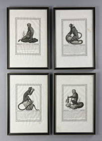
4 19th C. Framed Italian Monkey EngravingsEpic Auctions and Estate Sales4.6(204)See Sold PriceMar 02, 2024
1758 MAP PARTIE DE LA MER GLACIALE contenants La Nouvelle Zemble RUSSIA antiqueJasper524.5(9.8k)See Sold PriceFeb 27, 2024
1749 MAP CARTE DE LA TARTARIE ORIENTALE RUSSIA & CHINA antique EASTERN TARTARYJasper524.5(9.8k)See Sold PriceFeb 27, 2024
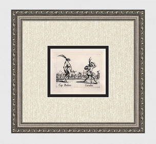
Limited 1920 CALLOT Engraving "Capitano Babeo & Cucuba" FramedKCM Galleries4.7(164)See Sold PriceFeb 25, 2024
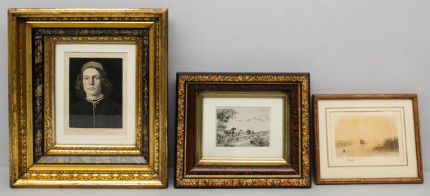
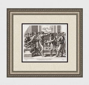
Jean Jacques Scherrer 1800s Antique Print Idol of the People FramedKCM Galleries4.7(164)See Sold PriceFeb 25, 2024
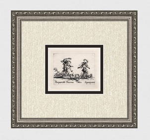
1920 Jacques Callot Engraving "Pasquariello & Squaquara" Limited FramedKCM Galleries4.7(164)See Sold PriceFeb 25, 2024
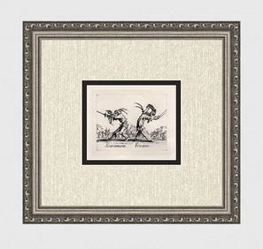
1920 Jacques CALLOT Limited Engraving "Scaramucia & Fricasso" FramedKCM Galleries4.7(164)See Sold PriceFeb 25, 2024
Jacques Nicolas Bellin - Antique Map - Vue de la Rade de Tiniam, double antique coast view of theProverde Auctions4.3(3)See Sold PriceFeb 28, 2024
Jacques Nicolas Bellin - View of the entrance to Zihuatanejo Bay - View of the entrance to the portProverde Auctions4.3(3)See Sold PriceFeb 28, 2024
Map of United States of North America, 1785Antiques Online Auctions4.6(407)See Sold PriceMar 14, 2024
Antique Map of Poland, 1700 by Guillaume De Lisle, ParisAntiques Online Auctions4.6(407)See Sold PriceMar 14, 2024
Antique Map of France, 1703 by Gillaume Del Isle PrintAntiques Online Auctions4.6(407)See Sold PriceMar 14, 2024