Marc Chagall-Limited Edition -Paris Opera Ceiling after ChagallArt Legacy Auctions4.5(217)See Sold PriceFeb 24, 2024
Salvador Dali Pantagruel Limited Edition Lithograph Hand signed and numberedArt Legacy Auctions4.5(217)See Sold PriceFeb 24, 2024
Pablo Picasso Bouquet of Peace Collection Domaine Picasso Limited Edition on paper.Art Legacy Auctions4.5(217)See Sold PriceFeb 24, 2024
A RARE MAXFIELD PARRISH JACK AND THE BEANSTALK PRINTSoulis Auctions4.8(953)See Sold PriceFeb 24, 2024
LARGE MECHANICAL PRINT 'STARS' AFTER MAXFIELD PARRISHSoulis Auctions4.8(953)See Sold PriceFeb 24, 2024
Heinrich Aldegrever, etc. 15 old master prints. 16th-17th centuries. Aldegrever works include "ManTremont Auctions4.6(293)See Sold PriceFeb 25, 2024
Sold[MAP]. HALSALL & Colton. Kansas. 1857.308. [MAP]. HALSALL, John (publisher) and J[oseph] H[utchins] Colton (copyright holder). Sectional Map of the Territory of Kansas Compiled from the Field Notes in the Surveyor General’s Office.See Sold Price
1857 Colton Map of Kansas and Nebraska -- Kansas andTitle: 1857 Colton Map of Kansas and Nebraska -- Kansas and Nebraska Date: 1857, New York Cartographer: J Colton Size: 24.5 X 15. 9 in. Additional Information: This is an outstanding Colton map.It shoSee Sold Price
Sold1857 Colton Map of Kansas and Nebraska -- Kansas andTitle: 1857 Colton Map of Kansas and Nebraska -- Kansas and Nebraska Cartographer: J Colton Year / Place: 1857, New York Map Dimension (in.): 24.5 X 15. 9 in. This is an outstanding Colton map. It shoSee Sold Price
1857 Colton Map of Kansas and Nebraska -- Kansas andTitle/Content of Map: 1857 Colton Map of Kansas and Nebraska -- Kansas and Nebraska Date: 1857, New York Cartographer: J Colton Size: 24.5 X 15. 9 in. This is an outstanding Colton map. It shows the eSee Sold Price
1857 Colton Map of Kansas and Nebraska -- Kansas andTitle/Content of Map: 1857 Colton Map of Kansas and Nebraska -- Kansas and Nebraska Cartographer: J Colton Year/Place: 1857, New York Size: 24.5 X 15. 9 in. This is an outstanding Colton map. It showsSee Sold Price
1857 Colton Map of Kansas and Nebraska -- Kansas andReserve Reduced! Title/Content of Map: 1857 Colton Map of Kansas and Nebraska -- Kansas and Nebraska Date: 1857, New York Cartographer: J Colton Size: 24.5 X 15. 9 in. This is an outstanding Colton maSee Sold Price
SoldJ.H. Colton & Co.: Kansas & Nebraska 1857Map: Kansas and Nebraska Publishing: J.H. Colton & Co., Colton, Joesph Hutchins Date: 1857 Size: 24.3 x 15.75 inches Early development of Kansas and Nebraska in 1857. Shows railroads and common roads.See Sold Price
SoldFolding map of Kansas 1857Heading: Author: Halsall, John Title: Sectional Map of the Territory of Kansas compiled from the field notes in the Surveyor General's Office Place Published: St. Louis, Mo. Publisher:Published by JoSee Sold Price
SoldFramed Map of Nebraska & Kansas 1857Framed Map of Nebraska & Kansas 1857 Published by J.H. Colton and Co. , a Territory acquired from Mexico by the Gadsden Treaty - Frame Approx. 32" x 24", Map itself is approx. 19" x 25"See Sold Price
SoldColton Map of Nebraska and KansasCOLTON, Joseph H. (1800-1893). Nebraska & Kansas. Lithograph with handcolor in part. New York, 1857. 30 1/2 x 22 1/2 inches sheet, 40 x 32 inches framed Striking map of Kansas and Nebraska, includingSee Sold Price
Colton Map of Nebraska and Kansas*** START PRICE IS THE RESERVE *** [America] COLTON, Joseph H. (1800-1893). Nebraska & Kansas. Lithograph with original hand color. New York, 1857. 30” x 22 1/2” sheet, 39” x 31 1/2” fraSee Sold Price
SoldHalsall, John. Map of the Territory of Kansas54. [MAP]. HALSALL, John. Sectional Map of the Territory of Kansas Compiled from the Field Notes in the Surveyor General's Office Published by John Halsall Saint Louis, Mo. 1857...Entered according toSee Sold Price
SoldOne of the most sought after maps of theCOLTON, Joseph H. (1800 - 1893). Nebraska and Kansas. Lithograph with original hand color. New York: 1857.31" x 22 3/4" sheet. 39 1/4" x 31 3/4" framed. Colton's map is the first printed map to show tSee Sold Price
Sold[John Halsall]. Sectional Map of the Territory o[John Halsall]. Sectional Map of the Territory of Kansas. CSee Sold Price
SoldAn Excellent Mid-19th Century Lithographed Map ofNebraska & Kansas. Joseph H. Colton. Lithograph with watercolor wash. New York, 1857. 31 x 23 inches sheet, 40 x 32 inches framed. Striking map of Kansas and Nebraska, including the routes across theSee Sold Price
SoldMAP OF KANSAS AND NEBRASKA TERRITORIES 1857By J.H. Colton, 25.5 x 17 inch sight size, professionally matted and framed in archival material.See Sold Price
SoldPrints and Maps.Great Lot of 19th century and earlier Prints and Maps. includes Colton 1857 Map of Greece, Hand Colored Plates, Steel Engravings and others. Great GroupSee Sold Price
Sold1857 Colton Co. map-making letter and decorativeHeading: (Map-making – Colton, 1857 letter) Author: Title: Colton Company proposal for an Iowa County map Place Published: New York Publisher: Date Published: Jan. 12, 1857 DescriptionSee Sold Price
SoldJ.H. Colton 1857 Map of Louisiana, hand-co.J.H. Colton 1857 Map of Louisiana, hand-co. NY:1857.Fifty mile scaleDimensions: 11 1/2" X 13 3/4"Inv.45See Sold Price
Sold1857 Colton Map of the Caribbean / West Indies -- WestTitle/Content of Map: 1857 Colton Map of the Caribbean / West Indies -- West Indies Cartographer: J Colton Year/Place: 1857, New York Size: 11.6 X 14.6 in. This is a very nice engraved map of the CariSee Sold Price
1857 Colton Map of the Caribbean / West Indies -- WestTitle: 1857 Colton Map of the Caribbean / West Indies -- West Indies Date: 1857, New York Cartographer: J Colton Size: 11.6 X 14.6 in. Additional Information: This is a very nice engraved map of the CSee Sold Price
Sold1857 Colton Map of Lake Superior and the Northern PartReserve Reduced! Title/Content of Map: 1857 Colton Map of Lake Superior and the Northern Part of Michigan -- Lake Superior and the Northern Part of Michigan Date: 1857, New York Cartographer: J ColtonSee Sold Price
Sold1857 Colton Map of Australia -- AustraliaReserve Reduced! Title/Content of Map: 1857 Colton Map of Australia -- Australia Date: 1855, New York Cartographer: J Colton Size: 12.5 X 14.6 in. This is a very nice map of Australia. The counties arSee Sold Price
1857 Colton Map of Argentina, Paraguay, Uruguay andTitle/Content of Map: 1857 Colton Map of Argentina, Paraguay, Uruguay and Chile -- Argentine Republic, Chili, Uruguay & Paraguay Date: 1855, New York Cartographer: J Colton Size: 14.6 X 11.6 in. ThisSee Sold Price
Official Railroad Map of Kansas-1907JM Hobby Supply and Railroad Artifact Auctions4.4(126)See Sold PriceFeb 24, 2024
Rand McNally County/Township/Railroad Map of Kansas-1911JM Hobby Supply and Railroad Artifact Auctions4.4(126)See Sold PriceFeb 24, 2024
DUNLEVIE c1856 Map Counties Of Gaspe & Bonaventure Quebec Canada SCARCE! #2Luis Porretta Fine Arts4.3(10)See Sold PriceMar 02, 2024
DEVINE c1856 Dr Salters Map Of Lake Huron Ontario Indian Lands etc. No. 7 ScarceLuis Porretta Fine Arts4.3(10)See Sold PriceMar 02, 2024
MATTHEWS c1856 Map Of Upper Canada Ontario Indian Land Agency Divisions Scarce!Luis Porretta Fine Arts4.3(10)See Sold PriceMar 02, 2024
DUNLEVIE c1856 Map Counties Of Gaspe & Bonaventure Quebec Canada SCARCE! #1Luis Porretta Fine Arts4.3(10)See Sold PriceMar 02, 2024
19thc Colton Map, Comparitive Size of Lakes & IslandsConnoisseur Auctions4(333)See Sold PriceFeb 24, 2024
1853 Colton's Railroad & Township Map of Massachusetts, Rhode Island, and ConnecticutRail & Road Auctions4.6(165)See Sold PriceMar 07, 2024
Pair of Early Railroad Maps - 1862 Pittsburgh, Ft. Wayne & Chicago Railway and 1873 PennsylvaniaRail & Road Auctions4.6(165)See Sold PriceMar 07, 2024
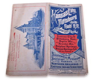
1895 Kansas City, Pittsburg & Gulf Railroad Public TimetableRail & Road Auctions4.6(165)See Sold PriceMar 08, 2024
Kansas City Southern Railway Timetable March 1910Rail & Road Auctions4.6(165)See Sold PriceMar 08, 2024
Map of Part of the West Indies, Etc., Showing the Exact Position Of The U.S. War Steamer SanJasper524.5(9.8k)See Sold PriceFeb 27, 2024
WEST AFRICA Explorers' routes Senegal Ashanti. Mountains of Kong. SDUK 1857 mapJasper524.5(9.8k)See Sold PriceFeb 28, 2024
West Africa. Liberia Sahara Senegambia Guinea. Mountains of Kong COLTON 1869 mapJasper524.5(9.8k)See Sold PriceFeb 28, 2024
North west Africa. Liberia inset. Sahara Senegambia Guinea. COLTON 1863 mapJasper524.5(9.8k)See Sold PriceFeb 28, 2024
Rare 19thc Colton Map, Argentine Republic, Chile, Uruguay, PataguayConnoisseur Auctions4(333)See Sold PriceMar 16, 2024
Francis McNally - Antique Map of Nebraska, Kansas, Dakota, Colorado & MontanaProverde Auctions4.3(3)See Sold PriceFeb 28, 2024
Reprint From The Original Coltons Map 1855 No.30 Copyright 1967Rapid Estate Liquidators and Auction Gallery4.5(1.1k)See Sold PriceFeb 29, 2024
![[MAP]. HALSALL & Colton. Kansas. 1857. First Image](https://p1.liveauctioneers.com/514/38482/16487220_1_x.jpg?height=282&quality=95&version=1363615005&width=282)

![[MAP]. HALSALL & Colton. Kansas. 1857. First Image](https://p1.liveauctioneers.com/514/38482/16487220_1_x.jpg?height=282&quality=1&version=1363615005&width=282)


![[MAP]. HALSALL & Colton. Kansas. 1857. (1 of 4)](https://p1.liveauctioneers.com/514/38482/16487220_1_x.jpg?height=282&quality=70&version=1363615005)


![[John Halsall]. Sectional Map of the Territory o (1 of 2)](https://p1.liveauctioneers.com/906/93415/47683694_1_x.jpg?height=282&quality=70&version=1473203012)