ATLAS of ANTIENT GEOGRAPHY by SAMUEL BUTLER 1843John McInnis Auctioneers,LLC4.6(502)See Sold PriceFeb 24, 2024
18TH C. ANTIQUE MAP: FRENCH & INDIAN WAR, FRAMEDThomaston Place Auction Galleries4.4(386)See Sold PriceFeb 24, 2024
Rand McNally Railroad Map Cabinet w/ 21 Railroad MapsRail & Road Auctions4.6(165)See Sold PriceMar 08, 2024
Keith Haring - Ink on New York Map, Best Buddies, Inscribed, Signed, and DatedSapphire Auction Gallery4(67)See Sold PriceMar 02, 2024
LATE 17TH C. FRENCH MAP OF THE NEW WORLD BY ALEXIS-HUBERT JAILLOT (1632-1712)Thomaston Place Auction Galleries4.4(386)See Sold PriceFeb 24, 2024
Central Railroad of New Jersey Map of Sandy Hook Route-ca. 1903JM Hobby Supply and Railroad Artifact Auctions4.4(126)See Sold PriceFeb 24, 2024
Lot of Six Mixed Atlas Box Cars-HO Scale-New in BoxJM Hobby Supply and Railroad Artifact Auctions4.4(126)See Sold PriceFeb 25, 2024
Rand McNally/Santa Fe Railroad Map of Iowa-1912JM Hobby Supply and Railroad Artifact Auctions4.4(126)See Sold PriceFeb 24, 2024
NICOLAES VISSCHER (NETHERLANDS, 1618-1709) MAP OF THE NEW WORLDThomaston Place Auction Galleries4.4(386)See Sold PriceFeb 24, 2024
17TH C. WORLD MAP BY NICOLAES VISSCHER (NETHERLANDS, 1618-1709)Thomaston Place Auction Galleries4.4(386)See Sold PriceFeb 24, 2024
Lot of Six Mixed Atlas Cabooses-HO Scale-New in BoxJM Hobby Supply and Railroad Artifact Auctions4.4(126)See Sold PriceFeb 25, 2024
Antique Map of Europe - Switzerland - Zürich - Geneva - Bern - James BarlowTitle: Antique Map of Europe - Switzerland - Zürich - Geneva - Bern - James Barlow Date: 1806 Material: Paper Dimensions: 10” x 8” inches / 25 cm x 21 cm Descritpion: Antique map of SSee Sold Price
Antique Map of Europe - Switzerland - Zürich - Geneva - Bern - James BarlowTitle: Antique Map of Europe - Switzerland - Zürich - Geneva - Bern - James Barlow Description: Antique map of Switzerland with its subjects & allies from the best authorities, 1806. Technique: ESee Sold Price
Antique Map of Europe - Switzerland - Zürich - Geneva - Bern - Alexander FindlayTitle/Artist: Antique Map of Europe - Switzerland - Zürich - Geneva - Bern - Alexander Findlay Date/Period: 1843 Material: Paper Dimensions: 24 cm x 30 cm Description: Original antique hand-colorSee Sold Price
Antique Map Print - Europe - Map of Switzerland - Zurich - Philipp Cluver - 1701Title/Artist: Antique Map Print - Europe - Map of Switzerland - Zurich - Philipp Cluver - 1701 Date: 1701 Material: Paper Dimensions: 14 cm x 13 cm Additional Information: A detailed small map from &#See Sold Price
Antique Map of Europe - Germany - Berlin - Bavaria - Hamburg - James BarlowTitle/Content: Antique Map of Europe - Germany - Berlin - Bavaria - Hamburg - James Barlow Date: 1806 Material: Paper Dimensions: 10” x 8” inches / 25 cm x 21 cm Description: Antique map oSee Sold Price
Antique Map of Europe - England & Wales - United Kingdom - London - James BarlowTitle/Content: Antique Map of Europe - England & Wales - United Kingdom - London - James Barlow Date: 1806 Material: Paper Dimensions: 10” x 8” inches / 25 cm x 21 cm Description: AntiqueSee Sold Price
EUROPE. Brussels, Amsterdam, Berne, L. Geneva. Vaud Fribourg 1897 old mapTITLE/CONTENT OF MAP: 'Brussels, Amsterdam, Bern, L. Geneva' DATE PRINTED: 1897 IMAGE SIZE: Approx 20.5 x 26.5cm, 8 x 10.25 inches (Medium) TYPE: Antique coloured map CONDITION: Good; suitable for fraSee Sold Price
EUROPE. Brussels, Amsterdam, Berne, L. Geneva. Vaud Fribourg 1897 old mapTITLE/CONTENT OF MAP: 'Brussels, Amsterdam, Bern, L. Geneva' DATE PRINTED: 1897 IMAGE SIZE: Approx 20.5 x 26.5cm, 8 x 10.25 inches (Medium) TYPE: Antique coloured map CONDITION: Good; suitable for fraSee Sold Price
Antique Map of Europe - Netherlands - Holland - Rotterdam - Amsterdam - BarlowTitle: Antique Map of Europe - Netherlands - Holland - Rotterdam - Amsterdam - Barlow Description: Antique map of Netherlands from the best authorities, 1806. Technique: Engraving. Date: 1806. Artist:See Sold Price
Antique Map of Europe - Netherlands - Holland - Rotterdam - Amsterdam - BarlowTitle/Content: Antique Map of Europe - Netherlands - Holland - Rotterdam - Amsterdam - Barlow Date: 1806 Material: Paper Dimensions: 10” x 8” inches / 25 cm x 21 cm Description: Antique maSee Sold Price
SoldBarlow 1807 Antique Map of Europe ContinentCopper Engraved Map Published 1807 by Brightly & Kinnersley, Bungay, England for "A General View of the World, Geographical, Historical and Philosophical" by The Rev. E. Blomfield. Maps Engraved by BaSee Sold Price
SoldBryce, James 1881 Antique Map of EuropeLithograph Map Published 1881, London for ""The International Atlas and Geography..." by James Bryce. Maps by Edward Weller & John Bartholomew. Uncommon. Paper Size: 18 x 13 inch (46 x 33cm) Good CondSee Sold Price
SoldBarlow 1807 Antique Map of Europe ContinentCopper Engraved Map Published 1807 by Brightly & Kinnersley, Bungay, England for "A General View of the World, Geographical, Historical and Philosophical" by The Rev. E. Blomfield. Maps Engraved by BaSee Sold Price
SoldBarclay, James 1809 Antique Map. Russia in EuropeOutline Hand Coloured Copper Engraved Map Published 1809, Leeds for "Barclay's Complete and Universal Dictionary of the English Language..." by the Rev. James Barclay. Paper Size: 10 x 8 inch (26 x 20See Sold Price
The Alps. Europe. Switzerland Italy France Austria. BARTHOLOMEW 1886 old mapTITLE/CONTENT OF MAP: 'Central chain of the Alps' DATE PRINTED: 1886 IMAGE SIZE: Approx 16.0 x 24.0cm, 6.25 x 9.5 inches (Medium) TYPE: Antique colour map CONDITION: Good; suitable for framing. HoweveSee Sold Price
The Alps. Europe. Switzerland Italy France Austria. BARTHOLOMEW 1886 old mapTITLE/CONTENT OF MAP: 'Central chain of the Alps' DATE PRINTED: 1886 IMAGE SIZE: Approx 16.0 x 24.0cm, 6.25 x 9.5 inches (Medium) TYPE: Antique colour map CONDITION: Good; suitable for framing. HoweveSee Sold Price
South-west & Central Europe. Switzerland includes Haute-Savoie. THOMSON 1830 mapTITLE/CONTENT OF MAP: 'Carte de l'Europe [Map of Europe]' DATE PRINTED: c1871 IMAGE SIZE: Approx 33.5 x 46.5cm, 13.25 x 18.25 inches (Large); Please note that this is a folding map. TYPE: Antique 19thSee Sold Price
Europe. Unified Benelux. Switzerland includes Haute-Savoie. THOMSON 1830 mapTITLE/CONTENT OF MAP: 'Sweden & Norway' DATE PRINTED: 1882 IMAGE SIZE: Approx 50.5 x 35.5cm, 20 x 14 inches (Large); Please note that this is a folding map. TYPE: Antique colour map CONDITION: Good; sSee Sold Price
SoldAntique Maps, Netherlands, England, Chinon, EuropeA group of five smaller framed antique maps. Comprised of 1) The United Provinces or Netherlands, H. Moll Geographer, 2) Bowles Post Chase Companion, London to Newmarket, etc. Published 1782, 3) ChinoSee Sold Price
Central Europe rivers & regions. Germany SwitzerlandTITLE/CONTENT OF MAP: Germany: 'Index Map Sheet XIII' DATE PRINTED: 1800 IMAGE SIZE: Approx 43.5 x 44.0cm, 17 x 17.25 inches (Large) TYPE: Large folio antique engraved map CONDITION: Good; suitable foSee Sold Price
Sold12V James Bell A SYSTEM OF GEOGRAPHY 1839‐12V James Bell A SYSTEM OF GEOGRAPHY 1839‐1840 Complete Set Antique Engraved Folding Maps Plates Illustrated History Europe Asia South America Asia Minor Islands Australia North America CartSee Sold Price
SoldBarclay, James 1809 Antique Map. Turkey & Black Sea"Turkey in Europe with Asia Minor" Outline Hand Coloured Copper Engraved Map Published 1809, Leeds for "Barclay's Complete and Universal Dictionary of the English Language..." by the Rev. James BarclaSee Sold Price
Vandermaelen: Antique Map of Northern Italy, 1827TITLE/CONTENT OF MAP: 'Europe - Partie de l'Italie - No 20 ' Most of the northern Italian states, Switzerland, the western Balkans, and the southern part of what is now Austria DATE PRINTED: 1827 IMAGSee Sold Price
Vandermaelen: Antique Map of Southern France & SavoieTITLE/CONTENT OF MAP: 'Europe - Partie de la France - No 19 ' Central and southern France, western Switzerland, and part of the Kingdom of Sardinia (now north-western Italy, Savoie and Alpes-MaritimesSee Sold Price
Two (2) Antique 18th C. Copper Engraved Framed Maps - America & EuropeMagnusson Art Group4.5(46)See Sold PriceMar 14, 2024
Mckenney & Hall - Two Octavo Volumes of Text with Rare Plate of Billy BowlegsTrillium Antique Prints & Rare Books4.5(30)See Sold PriceFeb 24, 2024
McKenney & Hall, Folio, Rare - 5 Native American LithographsTrillium Antique Prints & Rare Books4.5(30)See Sold PriceFeb 24, 2024
McKenney & Hall, Folio, Rare - Se-Quo-YahTrillium Antique Prints & Rare Books4.5(30)See Sold PriceFeb 24, 2024
McKenney & Hall, Folio, Rare - Hunting the BuffaloeTrillium Antique Prints & Rare Books4.5(30)See Sold PriceFeb 24, 2024
Audubon - Common Osprey Fish Hawk. 15Trillium Antique Prints & Rare Books4.5(30)See Sold PriceFeb 24, 2024
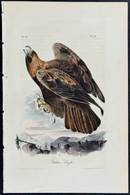
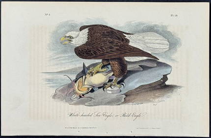
Audubon - White-headed Sea Eagle or Bald Eagle. 14Trillium Antique Prints & Rare Books4.5(30)See Sold PriceFeb 24, 2024
Audubon - 8 Quadruped LithographsTrillium Antique Prints & Rare Books4.5(30)See Sold PriceFeb 24, 2024
Audubon, Imperial Folio - American Cross Fox. 6Trillium Antique Prints & Rare Books4.5(30)See Sold PriceFeb 24, 2024
Audubon, Imperial Folio - Canada Lynx. 16Trillium Antique Prints & Rare Books4.5(30)See Sold PriceFeb 24, 2024
1816 MAP NORTHERN PART OF RUSSIA or MUSCOVY in EUROPE copper engraving ANTIQUEJasper524.5(9.8k)See Sold PriceFeb 27, 2024
C. R. Knight - Falls of the Rhine at Schaffhausen - SwitzerlandProverde Auctions4.3(3)See Sold PriceFeb 28, 2024
Set of 3 Maps - Netherlands - Belgien - Switzerland - J. BarlowProverde Auctions4.3(3)See Sold PriceFeb 28, 2024