ATLAS of ANTIENT GEOGRAPHY by SAMUEL BUTLER 1843John McInnis Auctioneers,LLC4.6(502)See Sold PriceFeb 24, 2024
18TH C. ANTIQUE MAP: FRENCH & INDIAN WAR, FRAMEDThomaston Place Auction Galleries4.4(386)See Sold PriceFeb 24, 2024
Rand McNally Railroad Map Cabinet w/ 21 Railroad MapsRail & Road Auctions4.6(165)See Sold PriceMar 08, 2024
Keith Haring - Ink on New York Map, Best Buddies, Inscribed, Signed, and DatedSapphire Auction Gallery4(67)See Sold PriceMar 02, 2024
LATE 17TH C. FRENCH MAP OF THE NEW WORLD BY ALEXIS-HUBERT JAILLOT (1632-1712)Thomaston Place Auction Galleries4.4(386)See Sold PriceFeb 24, 2024
Central Railroad of New Jersey Map of Sandy Hook Route-ca. 1903JM Hobby Supply and Railroad Artifact Auctions4.4(126)See Sold PriceFeb 24, 2024
Lot of Six Mixed Atlas Box Cars-HO Scale-New in BoxJM Hobby Supply and Railroad Artifact Auctions4.4(126)See Sold PriceFeb 25, 2024
Rand McNally/Santa Fe Railroad Map of Iowa-1912JM Hobby Supply and Railroad Artifact Auctions4.4(126)See Sold PriceFeb 24, 2024
NICOLAES VISSCHER (NETHERLANDS, 1618-1709) MAP OF THE NEW WORLDThomaston Place Auction Galleries4.4(386)See Sold PriceFeb 24, 2024
17TH C. WORLD MAP BY NICOLAES VISSCHER (NETHERLANDS, 1618-1709)Thomaston Place Auction Galleries4.4(386)See Sold PriceFeb 24, 2024
Lot of Six Mixed Atlas Cabooses-HO Scale-New in BoxJM Hobby Supply and Railroad Artifact Auctions4.4(126)See Sold PriceFeb 25, 2024
Antique Map Print - Europe - Map of Ancient Italy - Southern Europe - Rome 1701Title: Antique Map Print - Europe - Map of Ancient Italy - Southern Europe - Rome 1701 Description: A detailed small map from ”Introductionis in universam Geographiam…” accessit P. BSee Sold Price
Antique Map Print - Europe - Italy's Latest Registration - Philipp Cluver - 1701Title/Artist: Antique Map Print - Europe - Italy's Latest Registration - Philipp Cluver - 1701 Date/Period: 1701 Material: Paper Dimensions: 15 cm x 13 cm Description: A detailed small map from ”See Sold Price
Antique Map Print - Europe - Map of Southern Norway to Carpelan - Meyer - 1852Title/Content: Antique Map Print - Europe - Map of Southern Norway to Carpelan - Meyer - 1852 Date: 1852 Material: Paper Dimensions: 12” x 9” inches / 31 cm x 24 cm Description: Map of SouSee Sold Price
Antique Map Print - Europe - Map of Switzerland - Zurich - Philipp Cluver - 1701Title/Artist: Antique Map Print - Europe - Map of Switzerland - Zurich - Philipp Cluver - 1701 Date: 1701 Material: Paper Dimensions: 14 cm x 13 cm Additional Information: A detailed small map from &#See Sold Price
Antique Map Print - Europe - Northern Italy - Corsica - Milan - Vaugondy 1806Title/Content: Antique Map Print - Europe - Northern Italy - Corsica - Milan - Vaugondy 1806 Date: 1806 Material: Paper Dimensions: 12” x 9” inches / 31,5 cm x 24 cm Description: OriginalSee Sold Price
Antique Map Print - Europe - Map of Cisrhenian Germans - Philipp Cluver - 1701Title/Artist: Antique Map Print - Europe - Map of Cisrhenian Germans - Philipp Cluver - 1701 Date: 1701 Material: Paper Dimensions: 14 cm x 13 cm Additional Information: A detailed small map from RSee Sold Price
Antique Map Print - Europe - Map of British Isles - United Kingdom - Cluver 1701Title/Artist: Antique Map Print - Europe - Map of British Isles - United Kingdom - Cluver 1701 Date/Period: 1701 Material: Paper Dimensions: 14 cm x 13 cm Description: A detailed small map from ”See Sold Price
Antique Map Print - Europe - Map of Low German - Hamburg - Philipp Cluver - 1701Title/Content: Antique Map Print - Europe - Map of Low German - Hamburg - Philipp Cluver - 1701 Date: 1701 Material: Paper Dimensions: 6” x 5” inches / 14 cm x 13 cm Description: A detaileSee Sold Price
Antique Map Print - Europe - Map of British Isles - United Kingdom - Cluver 1701Title/Artist: Antique Map Print - Europe - Map of British Isles - United Kingdom - Cluver 1701 Date: 1701 Material: Paper Dimensions: 14 cm x 13 cm Additional Information: A detailed small map from &#See Sold Price
Antique Map Print - Europe - Typus Hispaniae Veteris - Types of Old Spain 1701Title/Artist: Antique Map Print - Europe - Typus Hispaniae Veteris - Types of Old Spain 1701 Date/Period: 1701 Material: Paper Dimensions: 15 cm x 13 cm Description: A detailed small map from ”ISee Sold Price
Antique Map Print - Europe - Map of Liguria - Region of Italy - Philipp CluverTitle: Antique Map Print - Europe - Map of Liguria - Region of Italy - Philipp Cluver Date: 1701 Material: Paper Dimensions: 6” x 5” inches / 15 cm x 13 cm Descritpion: A detailed small maSee Sold Price
Antique Map Print - Europe - Map of Etruria, Latium, Umbria - Regions of ItalyTitle: Antique Map Print - Europe - Map of Etruria, Latium, Umbria - Regions of Italy Description: A detailed small map from ”Introductionis in universam Geographiam…” accessit P. BeSee Sold Price
Antique Map Print - Europe - Map of Etruria, Latium, Umbria - Regions of ItalyTitle: Antique Map Print - Europe - Map of Etruria, Latium, Umbria - Regions of Italy Date: 1701 Material: Paper Dimensions: 6” x 5” inches / 15 cm x 13 cm Descritpion: A detailed small maSee Sold Price
Map of ancient Italy. Europe 1828.Print of steel engraving titled Italie antique“.Author Fellx Delamarche.Engraved by unknown.From Atlas de la Geographie ancienne du moyen age et moderne“ by Fellx Delamarche. Paris. 1829.Flix DelaSee Sold Price
Antique Map - Europe - Major Monuments and the Seven Hills - Ancient Rome, 1704Title/Artist: Antique Map - Europe - Major Monuments and the Seven Hills - Ancient Rome, 1704 Date: 1704 Material: Paper Dimensions: 39 cm x 24 cm Description: It is a map of ancient Rome illustratingSee Sold Price
Antique Map of Europe - Map of Main Chain of The Alps - Mont Blanc - ItalyTitle: Antique Map of Europe - Map of Main Chain of The Alps - Mont Blanc - Italy Date/Period: 1858 Dimension: 26 cm x 16 cm Material: Paper Additional Information: Interesting antique map from ‘See Sold Price
Antique Map - Europe - Major Monuments and the Seven Hills - Ancient Rome, 1704It is a map of ancient Rome illustrating major monuments and the Seven Hills. The seven hills of Rome east of the river Tiber form the geographical heart of Rome, within the walls of the city. The autSee Sold Price
Antique Map Print - Europe - Map of Silesia - Poland - Czech Republic - WroclawTitle/Artist: Antique Map Print - Europe - Map of Silesia - Poland - Czech Republic - Wroclaw Date/Period: 17th Century Material: Paper Dimensions: 20 cm x 13 cm Description: Map of Silesia. Silesia iSee Sold Price
Antique Map Print - Europe - Map of Silesia - Poland - John Cary - 1816Title/Artist: Antique Map Print - Europe - Map of Silesia - Poland - John Cary - 1816 Date/Period: 1816 Material: Paper Dimensions: 36 cm x 29 cm Description: An excellent detailed regional map of SilSee Sold Price
Antique Map Print - Europe - Map of Germany - Hand Colored Engraving JaillotTitle/Artist: Antique Map Print - Europe - Map of Germany - Hand Colored Engraving Jaillot Date/Period: 1785 Material: Paper Dimensions: 22 cm x 17 cm Description: Antique map of Germany. Hand coloredSee Sold Price
Antique Map Print - Europe - Map of a Silesia with the Lausnitz - Poland - CzechTitle/Artist: Antique Map Print - Europe - Map of a Silesia with the Lausnitz - Poland - Czech Date/Period: 18th Century Material: Paper Dimensions: 42 cm x 37 cm Description: A nice and detailed mapSee Sold Price
Antique Map Print - Europe - Map of Silesia - Czech Republic - Wroclaw - PolandTitle/Artist: Antique Map Print - Europe - Map of Silesia - Czech Republic - Wroclaw - Poland Date/Period: 17th Century Material: Paper Dimensions: 18 cm x 12 cm Description: Map of Silesia. Silesia iSee Sold Price
Antique Map Print - Europe - Map of France - Alsace, Strasbourg & Rhine RiverTitle: Antique Map Print - Europe - Map of France - Alsace, Strasbourg & Rhine River Date/Period: 1690 Dimension: 59 cm x 51 cm Material: Paper Additional Information: Alsatiae Landgraviatus, DucatusSee Sold Price
Antique Map Print - Europe - Map of Belgium - Luxembourg - Northern FranceTitle: Antique Map Print - Europe - Map of Belgium - Luxembourg - Northern France Date/Period: 1720 Dimension: 61 cm x 53 cm Material: Paper Additional Information: Johann Baptist Homann. Arena MartisSee Sold Price
Carey, pub. 1796 - A Chart of the West IndiesTrillium Antique Prints & Rare Books4.5(30)See Sold PriceFeb 24, 2024
Carey, pub. 1796 - Map of the State of MarylandTrillium Antique Prints & Rare Books4.5(30)See Sold PriceFeb 24, 2024
Carey, pub. 1796 - Map of GeorgiaTrillium Antique Prints & Rare Books4.5(30)See Sold PriceFeb 24, 2024
Carey, pub. 1796 - Map of The State of South CarolinaTrillium Antique Prints & Rare Books4.5(30)See Sold PriceFeb 24, 2024
Carey, pub. 1796 - Map of KentuckyTrillium Antique Prints & Rare Books4.5(30)See Sold PriceFeb 24, 2024
Carey, pub. 1796 - Map of the Tennassee State formerly part of North Carolina (Tennessee)Trillium Antique Prints & Rare Books4.5(30)See Sold PriceFeb 24, 2024
AFRICA. Antiqua; Rome Carthage, start Punic War 1908 old antique map chartJasper524.5(9.8k)See Sold PriceFeb 28, 2024
Northern & Southern Africa. Maghreb. Orange River Sovereignty. HALL 1854 mapJasper524.5(9.8k)See Sold PriceFeb 28, 2024
SOUTHERN AFRICA. Congo British/Portuguese/German East Africa Rhodesia 1912 mapJasper524.5(9.8k)See Sold PriceFeb 28, 2024
ANCIENT AFRICA cum Aegypto et Insulis. Nigritae Aethiopia. ARROWSMITH 1828 mapJasper524.5(9.8k)See Sold PriceFeb 28, 2024
World War 2 Europe Battle of the Atlantic 1939-43 Axis Expansion limits 1959 mapJasper524.5(9.8k)See Sold PriceFeb 28, 2024
SOUTHERN AFRICA & MALAY ARCHIPELAGO. Cape Colony Indonesia &c. BUTLER 1888 mapJasper524.5(9.8k)See Sold PriceFeb 28, 2024
ANCIENT NORTH AFRICA Septentrionalis. Mauretania Tripolitana ARROWSMITH 1828 mapJasper524.5(9.8k)See Sold PriceFeb 28, 2024
SUB-SAHARAN AFRICA. 'Ancienne Ethiopie'. Ancient Ethiopia. MALLET 1683 old mapJasper524.5(9.8k)See Sold PriceFeb 28, 2024
SOUTHERN AFRICA Monomotapa (Mutapa Kingdom) Cafrerie (Kaffraria) MALLET 1683 mapJasper524.5(9.8k)See Sold PriceFeb 28, 2024
Afrique Ancienne. Ancient North Africa. MALTE-BRUN c1871 old antique map chartJasper524.5(9.8k)See Sold PriceFeb 28, 2024
Jan Goeree (1670-1731) - Set of 2 Italian Engravings of Roman ScenesProverde Auctions4.3(3)See Sold PriceFeb 28, 2024
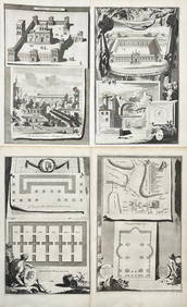
Jan Goeree (1670-1731) - Set av 4 Architecture Engravings - Church of Saint Pudentiana - AProverde Auctions4.3(3)See Sold PriceFeb 28, 2024
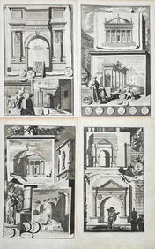
Jan Goeree (1670-1731) - Set av 4 Architecture Engravings - A Reconstruction of the Arch of DomitianProverde Auctions4.3(3)See Sold PriceFeb 28, 2024
Carl Johan Billmark - Set of 4 Prints depicting Rome, Italy - Church in Sweden - Views of EuropeProverde Auctions4.3(3)See Sold PriceFeb 28, 2024
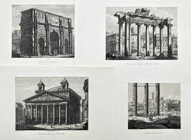
Domenico Amici - Set of 4 prints - Tempio di Giove Statore - Arco di Costantino in Rome, ItalyProverde Auctions4.3(3)See Sold PriceFeb 28, 2024