ATLAS of ANTIENT GEOGRAPHY by SAMUEL BUTLER 1843John McInnis Auctioneers,LLC4.5(505)See Sold PriceFeb 24, 2024
18TH C. ANTIQUE MAP: FRENCH & INDIAN WAR, FRAMEDThomaston Place Auction Galleries4.4(393)See Sold PriceFeb 24, 2024
Rand McNally Railroad Map Cabinet w/ 21 Railroad MapsRail & Road Auctions4.6(165)See Sold PriceMar 08, 2024
Keith Haring - Ink on New York Map, Best Buddies, Inscribed, Signed, and DatedSapphire Auction Gallery4(67)See Sold PriceMar 02, 2024
LATE 17TH C. FRENCH MAP OF THE NEW WORLD BY ALEXIS-HUBERT JAILLOT (1632-1712)Thomaston Place Auction Galleries4.4(393)See Sold PriceFeb 24, 2024
Central Railroad of New Jersey Map of Sandy Hook Route-ca. 1903JM Hobby Supply and Railroad Artifact Auctions4.4(127)See Sold PriceFeb 24, 2024
Lot of Six Mixed Atlas Box Cars-HO Scale-New in BoxJM Hobby Supply and Railroad Artifact Auctions4.4(127)See Sold PriceFeb 25, 2024
Rand McNally/Santa Fe Railroad Map of Iowa-1912JM Hobby Supply and Railroad Artifact Auctions4.4(127)See Sold PriceFeb 24, 2024
NICOLAES VISSCHER (NETHERLANDS, 1618-1709) MAP OF THE NEW WORLDThomaston Place Auction Galleries4.4(393)See Sold PriceFeb 24, 2024
17TH C. WORLD MAP BY NICOLAES VISSCHER (NETHERLANDS, 1618-1709)Thomaston Place Auction Galleries4.4(393)See Sold PriceFeb 24, 2024
Lot of Six Mixed Atlas Cabooses-HO Scale-New in BoxJM Hobby Supply and Railroad Artifact Auctions4.4(127)See Sold PriceFeb 25, 2024
Antique Map Print - Europe - Italy's Latest Registration - Philipp Cluver - 1701Title/Artist: Antique Map Print - Europe - Italy's Latest Registration - Philipp Cluver - 1701 Date/Period: 1701 Material: Paper Dimensions: 15 cm x 13 cm Description: A detailed small map from ”See Sold Price
Antique Map Print - Europe - Map of British Isles - United Kingdom - Cluver 1701Title/Artist: Antique Map Print - Europe - Map of British Isles - United Kingdom - Cluver 1701 Date/Period: 1701 Material: Paper Dimensions: 14 cm x 13 cm Description: A detailed small map from ”See Sold Price
Map of ancient Italy. Europe 1828.Print of steel engraving titled Italie antique“.Author Fellx Delamarche.Engraved by unknown.From Atlas de la Geographie ancienne du moyen age et moderne“ by Fellx Delamarche. Paris. 1829.Flix DelaSee Sold Price
Antique Map - Europe - Major Monuments and the Seven Hills - Ancient Rome, 1704It is a map of ancient Rome illustrating major monuments and the Seven Hills. The seven hills of Rome east of the river Tiber form the geographical heart of Rome, within the walls of the city. The autSee Sold Price
Antique Map Print - Europe - Map of Silesia - Poland - Czech Republic - WroclawTitle/Artist: Antique Map Print - Europe - Map of Silesia - Poland - Czech Republic - Wroclaw Date/Period: 17th Century Material: Paper Dimensions: 20 cm x 13 cm Description: Map of Silesia. Silesia iSee Sold Price
Antique Map Print - Europe - Map of Germany - Hand Colored Engraving JaillotTitle/Artist: Antique Map Print - Europe - Map of Germany - Hand Colored Engraving Jaillot Date/Period: 1785 Material: Paper Dimensions: 22 cm x 17 cm Description: Antique map of Germany. Hand coloredSee Sold Price
Antique Map Print - Europe - Map of a Silesia with the Lausnitz - Poland - CzechTitle/Artist: Antique Map Print - Europe - Map of a Silesia with the Lausnitz - Poland - Czech Date/Period: 18th Century Material: Paper Dimensions: 42 cm x 37 cm Description: A nice and detailed mapSee Sold Price
Antique Map Print - Europe - Map of France - Alsace, Strasbourg & Rhine RiverTitle: Antique Map Print - Europe - Map of France - Alsace, Strasbourg & Rhine River Date/Period: 1690 Dimension: 59 cm x 51 cm Material: Paper Additional Information: Alsatiae Landgraviatus, DucatusSee Sold Price
Antique Map Print - Europe - Map of Sweden, Norway and Denmark - ScandinaviaTitle: Antique Map Print - Europe - Map of Sweden, Norway and Denmark - Scandinavia Date: 1825 Material: Paper Dimensions: 24” x 18,5” inches / 60 cm x 47 cm Descritpion: ”Carte geneSee Sold Price
Antique Map Print - Europe - Map of Mittelmark - Eastern Germany - BerlinTitle: Antique Map Print - Europe - Map of Mittelmark - Eastern Germany - Berlin Date/Period: 1680 Dimension: 57 cm x 47 cm Material: Paper Additional Information: Johannes Janssonius. Marchia Media vSee Sold Price
Antique Map Print - Europe - Roman Empire Eastern Part - Cyprus - Rigobert BonneTitle: Antique Map Print - Europe - Roman Empire Eastern Part - Cyprus - Rigobert Bonne Date/Period: 1787 Dimension: 43 cm x 30 cm Material: Paper Additional Information: Imperium Romanum Pars OrientaSee Sold Price
Antique Map Print - Europe - Sweden - Map of Gefle - Erik Gustav Ljunggren 1856Title: Antique Map Print - Europe - Sweden - Map of Gefle - Erik Gustav Ljunggren 1856 Date/Period: 1855 Dimension: 51 cm x 63 cm Material: Paper Additional Information: This historical map is includeSee Sold Price
Antique Map Print - Europe - Medieval Duchy in South-West Germany and PolandTitle/Content: Antique Map Print - Europe - Medieval Duchy in South-West Germany and Poland Date: 1701 Material: Paper Dimensions: 6” x 5” inches / 14 cm x 13 cm Description: A detailed smSee Sold Price
SoldStackhouse: Antique Map of Ancient Southern Italy, 1783Title/Content of Map: Ancient Central and Southern Italy Date Printed: 1783 Cartographer: Thomas Stackhouse Material/Medium: Paper Size: 16" x 20" Original hand color. Copperplate engraved. PublishedSee Sold Price
SoldMornas 1762 Ancient Europe MapSuite Du Table Au Charonologique De L'Histoire Universelle. Ancent Europe by B. De Mornas Circa 1762 from Atlas Historique Et Geographique. With antique gallery paper label on back. Image size: approxSee Sold Price
SoldRARE 1697 MAP SOUTHERN ITALY - CLUVERRare engraved antique map of Ancient Southern Italy, with a very decorative cartouch. In near fine condition, folded as issued. It is fully engraved to illustrate topography with ancient place names aSee Sold Price
Sold3 US MILITARY & FASCIST ITALY ROME MAP WWII EUROPELot of three includes: two (2) 43 X 27 inch Verdun-Wissembourg First Edition, sheet 57, Europe map, and one (1) 34 X 22 inch Pianta Panoramica Di Roma color map. Few wrinkles and tears, overall good cSee Sold Price
SoldHistorical map of southern Europe wiHistorical map of southern Europe with Italy and Greece, ''Fluviorum in Europa principis Danubii ... Graeciae et Achipelagi Novißima Tabula'', part col. Engraving by Homann c. 1720, medium facsimilSee Sold Price
Historical map of southern Europe wHistorical map of southern Europe with Italy and Greece, ''Fluviorum in Europa principis Danubii ... Graeciae et Achipelagi Novißima Tabula'', part col. Engraving by Homann c. 1720, wavy, spottedSee Sold Price
SoldCornell: Antique Map of West, Central & South EuropeTitle/Content of Map: Western, Central & Southern Continental Europe. Date Printed: 1857 Cartographer: CORNELL, SARAH SOPHIA Publisher: D. APPLETON 1857 NEW YORK Size: Folio – 12.60 H x 20.30 W InchSee Sold Price
Antique Map Print - Map of Mediterranean - Parts of Europe, Africa, Middle EastTitle: Antique Map Print - Map of Mediterranean - Parts of Europe, Africa, Middle East Date: 1725 Material: Paper Dimensions: 20” x 15” inches / 50 cm x 39 cm Descritpion: Fantastic antiquSee Sold Price
Antique Map of Europe - United Kingdom - France - Belgium - Italy - BeckerTitle/Artist: Antique Map of Europe - United Kingdom - France - Belgium - Italy - Becker Date/Period: 1843 Material: Paper Dimensions: 25 cm x 21 cm Description: Antique map of Europe by Becker, publiSee Sold Price
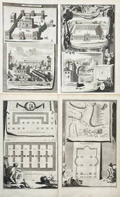
Antique Maps - Europe - Francois Halma - Italy - Giovanni Battista FaldaAfter the drawings and map by the architect Giovanni Battista Falda da Valdugga. 1704. It contains an amazing amount of detail consisting of: the Coliseum, Pantheon, St. Peter's Basilica, many streetsSee Sold Price
Vandermaelen: Antique Map of Southern Italy, 1827TITLE/CONTENT OF MAP: 'Europe - Naples et Sicile - No 26 ' Southern Italy including Sicily and Naples, and part of the adjacent coast of Albania DATE PRINTED: 1827 IMAGE SIZE: Approx 71.0 x 52.0cm, 27See Sold Price
Carey, pub. 1796 - A Chart of the West IndiesTrillium Antique Prints & Rare Books4.5(32)See Sold PriceFeb 24, 2024
Carey, pub. 1796 - Map of the State of MarylandTrillium Antique Prints & Rare Books4.5(32)See Sold PriceFeb 24, 2024
Carey, pub. 1796 - Map of GeorgiaTrillium Antique Prints & Rare Books4.5(32)See Sold PriceFeb 24, 2024
Carey, pub. 1796 - Map of The State of South CarolinaTrillium Antique Prints & Rare Books4.5(32)See Sold PriceFeb 24, 2024
Carey, pub. 1796 - Map of KentuckyTrillium Antique Prints & Rare Books4.5(32)See Sold PriceFeb 24, 2024
Carey, pub. 1796 - Map of the Tennassee State formerly part of North Carolina (Tennessee)Trillium Antique Prints & Rare Books4.5(32)See Sold PriceFeb 24, 2024
AFRICA. Antiqua; Rome Carthage, start Punic War 1908 old antique map chartJasper524.5(9.9k)See Sold PriceFeb 28, 2024
Northern & Southern Africa. Maghreb. Orange River Sovereignty. HALL 1854 mapJasper524.5(9.9k)See Sold PriceFeb 28, 2024
SOUTHERN AFRICA. Congo British/Portuguese/German East Africa Rhodesia 1912 mapJasper524.5(9.9k)See Sold PriceFeb 28, 2024
ANCIENT AFRICA cum Aegypto et Insulis. Nigritae Aethiopia. ARROWSMITH 1828 mapJasper524.5(9.9k)See Sold PriceFeb 28, 2024
World War 2 Europe Battle of the Atlantic 1939-43 Axis Expansion limits 1959 mapJasper524.5(9.9k)See Sold PriceFeb 28, 2024
SOUTHERN AFRICA & MALAY ARCHIPELAGO. Cape Colony Indonesia &c. BUTLER 1888 mapJasper524.5(9.9k)See Sold PriceFeb 28, 2024
ANCIENT NORTH AFRICA Septentrionalis. Mauretania Tripolitana ARROWSMITH 1828 mapJasper524.5(9.9k)See Sold PriceFeb 28, 2024
SUB-SAHARAN AFRICA. 'Ancienne Ethiopie'. Ancient Ethiopia. MALLET 1683 old mapJasper524.5(9.9k)See Sold PriceFeb 28, 2024
SOUTHERN AFRICA Monomotapa (Mutapa Kingdom) Cafrerie (Kaffraria) MALLET 1683 mapJasper524.5(9.9k)See Sold PriceFeb 28, 2024
Afrique Ancienne. Ancient North Africa. MALTE-BRUN c1871 old antique map chartJasper524.5(9.9k)See Sold PriceFeb 28, 2024
Jan Goeree (1670-1731) - Set of 2 Italian Engravings of Roman ScenesProverde Auctions4.3(3)See Sold PriceFeb 28, 2024
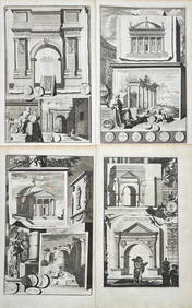
Jan Goeree (1670-1731) - Set av 4 Architecture Engravings - Church of Saint Pudentiana - AProverde Auctions4.3(3)See Sold PriceFeb 28, 2024
Jan Goeree (1670-1731) - Set av 4 Architecture Engravings - A Reconstruction of the Arch of DomitianProverde Auctions4.3(3)See Sold PriceFeb 28, 2024
Carl Johan Billmark - Set of 4 Prints depicting Rome, Italy - Church in Sweden - Views of EuropeProverde Auctions4.3(3)See Sold PriceFeb 28, 2024
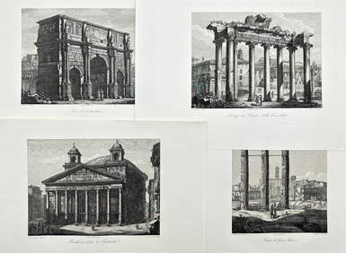
Domenico Amici - Set of 4 prints - Tempio di Giove Statore - Arco di Costantino in Rome, ItalyProverde Auctions4.3(3)See Sold PriceFeb 28, 2024