ATLAS of ANTIENT GEOGRAPHY by SAMUEL BUTLER 1843John McInnis Auctioneers,LLC4.5(505)See Sold PriceFeb 24, 2024
18TH C. ANTIQUE MAP: FRENCH & INDIAN WAR, FRAMEDThomaston Place Auction Galleries4.4(393)See Sold PriceFeb 24, 2024
Rand McNally Railroad Map Cabinet w/ 21 Railroad MapsRail & Road Auctions4.6(165)See Sold PriceMar 08, 2024
Keith Haring - Ink on New York Map, Best Buddies, Inscribed, Signed, and DatedSapphire Auction Gallery4(67)See Sold PriceMar 02, 2024
LATE 17TH C. FRENCH MAP OF THE NEW WORLD BY ALEXIS-HUBERT JAILLOT (1632-1712)Thomaston Place Auction Galleries4.4(393)See Sold PriceFeb 24, 2024
Central Railroad of New Jersey Map of Sandy Hook Route-ca. 1903JM Hobby Supply and Railroad Artifact Auctions4.4(127)See Sold PriceFeb 24, 2024
Lot of Six Mixed Atlas Box Cars-HO Scale-New in BoxJM Hobby Supply and Railroad Artifact Auctions4.4(127)See Sold PriceFeb 25, 2024
Rand McNally/Santa Fe Railroad Map of Iowa-1912JM Hobby Supply and Railroad Artifact Auctions4.4(127)See Sold PriceFeb 24, 2024
NICOLAES VISSCHER (NETHERLANDS, 1618-1709) MAP OF THE NEW WORLDThomaston Place Auction Galleries4.4(393)See Sold PriceFeb 24, 2024
17TH C. WORLD MAP BY NICOLAES VISSCHER (NETHERLANDS, 1618-1709)Thomaston Place Auction Galleries4.4(393)See Sold PriceFeb 24, 2024
Lot of Six Mixed Atlas Cabooses-HO Scale-New in BoxJM Hobby Supply and Railroad Artifact Auctions4.4(127)See Sold PriceFeb 25, 2024
World on Mercator's Projection. West sheet. Americas. 67x55cm. STANFORD 1904 mapCAPTION PRINTED BELOW PICTURE: A Chart of the World on Mercator's Projection shewing the principal Ocean Steam Routes, the Submarine Telegraphs, &c. [West Sheet] DATE PRINTED: 1904 IMAGE SIZE: ApproxSee Sold Price
Spanish-American War and WWII Pacific MapsPhillips' Special Map Illustrating the Spanish-American War,4 maps on one sheet, the Atlantic, the Seat of War in the West Indies, the Philippines, and the world on Mercator's projection, alsSee Sold Price
SoldFaden (William) World and 4 HemispheresFaden (William) World and 4 Hemispheres,5 sheets, outline world map on Mercator's projection, with the pair of north and south polar hemispheres, and the pair of east and west hemispheres, linSee Sold Price
SoldWorld On Mercator's ProjectionReserve Reduced! Title/Content of Map: World On Mercator's Projection Date: c1870 Cartographer: WALKER, J. & C. Material/Medium: EDWARD STANFORD/S.D.U.K. Size: 15.5Height - 24Width Two sheets joined.See Sold Price
SoldJohnson's World on Mercators Projection 1763-98Johnson's World on Mercators Projection, two-sheet map depicting the world c1763-1798. Each sheet 18" x 13 1/4". Unframed. Slight browning to margins.See Sold Price
World on Mercator's Projection. Centred on Americas. BARTHOLOMEW 1898 old mapTITLE OF MAP (NOT PRINTED ON THE PAGE):'The World on Mercator's Projection, with Ocean currents' DATE PRINTED: 1898 IMAGE SIZE: Approx 43.0 x 58.0cm, 17 x 22.75 inches (Large); Please note that this iSee Sold Price
World on Mercator's Projection. British Empire in Pink. STANFORD c1925 old mapCAPTION PRINTED BELOW PICTURE: 'The World, on Mercator's Projection' DATE PRINTED: The map is undated; we estimate publication at either 1924 or 1925 based on the content of the maps within the atlasSee Sold Price
Sold(MAP) MOLL, HERMAN. A New Map of the World according to(MAP) MOLL, HERMAN A New Map of the World According to Wright's Mercator's Projection. London, 1705. Engraved double-sheet map with hand-coloring. Framed and matted. 23 x 37 inches.See Sold Price
SoldCassell's Complete AtlasWeller (Edward) and others. Cassell's Complete Atlas [Dispatch Atlas],title and 258 of 260 listed and numbered map sheets, including the world on Mercator's projection, the continents, nationaSee Sold Price
Sold-. Teesdale (Henry)-. Teesdale (Henry) A New Chart of the World on Mercator's Projection, engraved map on 2 sheets, unjoined and hand-coloured, 1290 x 1935mm. overall, dissected and linen-backed, extensively staSee Sold Price
STANFORD, EDWARD. Stanford's Library Map of the WorldSTANFORD, EDWARD. Stanford's Library Map of the World on Mercator's Projection. Large lithographed case map of the world. 38x68 inches overall, dissected into 40 segments and mounted to original linenSee Sold Price
SoldSTANFORD, EDWARD. Stanford's Library Map of the WorldSTANFORD, EDWARD. Stanford's Library Map of the World on Mercator's Projection. Large lithographed case map of the world. 38x68 inches overall, dissected into 40 segments and mounted to original linenSee Sold Price
WORLD ON MERCATOR'S PROJECTION Chinese Outer Manchuria SDUK 1857 old mapTITLE/CONTENT OF MAP: 'WORLD ON MERCATOR'S PROJECTION' The non-existent Mountains of Kong are also shown on the map in West Africa DATE PRINTED: 1857 IMAGE SIZE: Approx 41.5 x 64.5cm, 16.25 x 25.25 inSee Sold Price
Pinkerton: The World on Mercators Projection, 1818Map: The World on Mercators Projection, 2 sheets Maker: John Pinkerton Date: c. 1818 Medium: Copperplate engraving Description: Two large double folio sheets comprising a world map on Mercator's ProjeSee Sold Price
SoldTeesdale (Henry) A New Chart of the World on MercaTeesdale (Henry) A New Chart of the World on Mercator's Projection,with the tracks of celebrated navigators, and showing Texas as an independent state, engraved map on two sheets, unjoined, wiSee Sold Price
SoldTeesdale (Henry) Chart of the WorldTeesdale (Henry) A New Chart of the World on Mercator's Projection, showing Texas as an independent state, engraved map on two sheets, unjoined, with full original hand-colouring, 1290 x 1935See Sold Price
Sold17th Century Blaeu World Map["Nova Totius Terrarum Orbis Geographica ac Hydrographica Tabula,"] by Willem Blaeu, Amsterdam, 1630 or later, based on Mercator's projection, engraved by Josua van den Ende, one-sheet map with insetSee Sold Price
World map On Mercator projection, 1780 by Bonne/ RaynalTitle: World map On Mercator projection, 1780 by Bonne/ Raynal Date/Period: 1780 Materials: Copperplate engraved Size: 13 1/2 x 9'' The world map shows a blank American west, misshaped Baffin Bay, AusSee Sold Price
Rare Small School Wall Map With Current Events;Burr, David H. (1803-1875). Map of the World on Mercator's Projection. Engraved map. S. W. chandler & Bro., c. 1850. 17 â…›" x 21" sheet. A good quality steel engraved Burr wall map surrounded wiSee Sold Price
SoldMiscellany.- - A large mixed group of maps,numerous schools and other atlas sheets, also some separate and folding maps, including a large World Map on Mercator's Projection, by Berghaus and Stülpnagel, North America by J. Harriosn after D'See Sold Price
World On Mercator's ProjectionTitle/Content of Map: World On Mercator's Projection Date Printed: 1840-03-15 Cartographer: WALKER, J. & C. Material/Medium: SOCIETY FOR THE DIFFUSION OF USEFUL KNOWLEDGE Size: 15.3X24 Two sheet worldSee Sold Price
SoldARROWSMITH, JOHN; and EDWARD STANFORD. A Chart of theARROWSMITH, JOHN; and EDWARD STANFORD. A Chart of the World on Mercator's Projection Shewing the Principal Ocean Steam Routes, the Submarine Telegraph, &c. Large engraved case map of the world with deSee Sold Price
Western Hemisphere. Americas. World on Mercator'sTITLE/CONTENT OF MAP: Chart of the World on Mercator's Projection [Western Hemisphere]The colouration of the map divides into zones or continents; this broadly corresponds to North, South and CentralSee Sold Price
SoldMaps: A Chart of the World on Mercator's Projection,Maps: A Chart of the World on Mercator's Projection, showing the principle ocean steam routes, the submarine telegraphs, &c. Mounted on linen. By J.Arrowsmith. Published by Edward Stanford , London. 1See Sold Price
Central Railroad of New Jersey Map of Sandy Hook Route-ca. 1903JM Hobby Supply and Railroad Artifact Auctions4.4(127)See Sold PriceFeb 24, 2024
Union Pacific RR Across The Continent West From Omaha, NE Book-April 2, 1868JM Hobby Supply and Railroad Artifact Auctions4.4(127)See Sold PriceFeb 24, 2024
17TH C. WORLD MAP BY NICOLAES VISSCHER (NETHERLANDS, 1618-1709)Thomaston Place Auction Galleries4.4(393)See Sold PriceFeb 24, 2024
LATE 17TH C. FRENCH MAP OF THE NEW WORLD BY ALEXIS-HUBERT JAILLOT (1632-1712)Thomaston Place Auction Galleries4.4(393)See Sold PriceFeb 24, 2024
LATE 16TH C. MAP OF SCOTLAND BY MERCATOR, FRAMEDThomaston Place Auction Galleries4.4(393)See Sold PriceFeb 24, 2024
NICOLAES VISSCHER (NETHERLANDS, 1618-1709) MAP OF THE NEW WORLDThomaston Place Auction Galleries4.4(393)See Sold PriceFeb 24, 2024
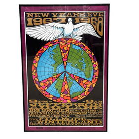
Vintage Jefferson Airplanes Big Brother New Years Eve 1967-68 Bill Graham Fillmore West ConcertPremier Auction Galleries4.4(331)See Sold PriceMar 09, 2024
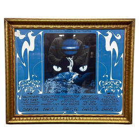
B.G 1971 Fillmore West Closing Week Poster. Grateful Dead, Santana, CCRPremier Auction Galleries4.4(331)See Sold PriceMar 09, 2024
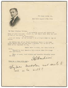
HOUDINI (Erik Weisz, 1874 – 1926). Houdini TLS to Fellow Ma...Potter & Potter Auctions4.6(545)See Sold PriceFeb 24, 2024
Vintage Full Color World Map LithographThe Benefit Shop Foundation Inc.4.3(2.9k)See Sold PriceFeb 28, 2024
Nova Totius Full Color Geographical World MapThe Benefit Shop Foundation Inc.4.3(2.9k)See Sold PriceFeb 28, 2024
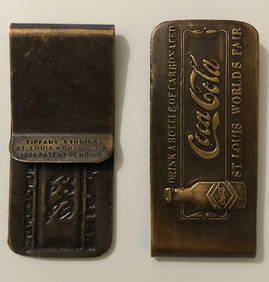
Tiffany 1904 St Louis World’s Fair COCA-COLA Money ClipSouth Florida Auction & Estate Sale Services Inc4.5(522)See Sold PriceMar 08, 2024
Rand McNally Railroad Map Cabinet w/ 21 Railroad MapsRail & Road Auctions4.6(165)See Sold PriceMar 08, 2024
Peter Max Better World III Painted LE Litho SIGNEDHill Auction Gallery 4.7(1k)See Sold PriceFeb 28, 2024
Arrowsmith & Lewis - Map of the World on Mercator's ProjectionTrillium Antique Prints & Rare Books4.5(32)See Sold PriceFeb 24, 2024
Carey, pub. 1796 - Map of the Tennassee State formerly part of North Carolina (Tennessee)Trillium Antique Prints & Rare Books4.5(32)See Sold PriceFeb 24, 2024
De Jode, Rare, pub. 1593 - Map of Africa (Africae Vera Forma, et Situs)Trillium Antique Prints & Rare Books4.5(32)See Sold PriceFeb 24, 2024
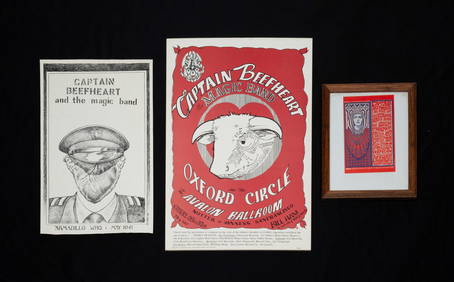
CAPTAIN BEEFHEART TWO POSTERS AND POSTCARD.Amelia Jeffers, Auctioneers & Appraisers4.5(120)See Sold PriceMar 09, 2024
Hamaguchi Mezzotint - Three Butterflies (Orange)Floating World Auctions4.7(236)See Sold PriceMar 01, 2024
Blackie (Pub) 1882 Folio Map. World on Mercators ProjectionAlbion Auctions4.6(341)See Sold PriceMar 01, 2024