ATLAS of ANTIENT GEOGRAPHY by SAMUEL BUTLER 1843John McInnis Auctioneers,LLC4.6(502)See Sold PriceFeb 24, 2024
18TH C. ANTIQUE MAP: FRENCH & INDIAN WAR, FRAMEDThomaston Place Auction Galleries4.4(386)See Sold PriceFeb 24, 2024
Rand McNally Railroad Map Cabinet w/ 21 Railroad MapsRail & Road Auctions4.6(165)See Sold PriceMar 08, 2024
Keith Haring - Ink on New York Map, Best Buddies, Inscribed, Signed, and DatedSapphire Auction Gallery4(67)See Sold PriceMar 02, 2024
LATE 17TH C. FRENCH MAP OF THE NEW WORLD BY ALEXIS-HUBERT JAILLOT (1632-1712)Thomaston Place Auction Galleries4.4(386)See Sold PriceFeb 24, 2024
Central Railroad of New Jersey Map of Sandy Hook Route-ca. 1903JM Hobby Supply and Railroad Artifact Auctions4.4(126)See Sold PriceFeb 24, 2024
Lot of Six Mixed Atlas Box Cars-HO Scale-New in BoxJM Hobby Supply and Railroad Artifact Auctions4.4(126)See Sold PriceFeb 25, 2024
Rand McNally/Santa Fe Railroad Map of Iowa-1912JM Hobby Supply and Railroad Artifact Auctions4.4(126)See Sold PriceFeb 24, 2024
NICOLAES VISSCHER (NETHERLANDS, 1618-1709) MAP OF THE NEW WORLDThomaston Place Auction Galleries4.4(386)See Sold PriceFeb 24, 2024
17TH C. WORLD MAP BY NICOLAES VISSCHER (NETHERLANDS, 1618-1709)Thomaston Place Auction Galleries4.4(386)See Sold PriceFeb 24, 2024
Lot of Six Mixed Atlas Cabooses-HO Scale-New in BoxJM Hobby Supply and Railroad Artifact Auctions4.4(126)See Sold PriceFeb 25, 2024
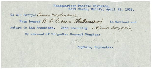
A General Map of Saxony & Bohemia with the adjacent countries. GIBSON 1760TITLE/CONTENT OF MAP: 'A General Map of Saxony and Bohemia with the adjacent Countries including Silesia' DATE PRINTED: 1760 IMAGE SIZE: Approx 25.0 x 37.0cm, 9.75 x 14.5 inches (Large); Please note tSee Sold Price
General Map of Saxony and Bohemia, With the AdjacentTitle: General Map of Saxony and Bohemia, With the Adjacent Countries, Including Silesia. Publication Date: c1770 Cartographer: GIBSON, J. Size: 9.6Height - 14.5Width Additional Information: Being a SSee Sold Price
Sold1760 Map of Saxony and Bohemia“A General Map of Saxony and Bohemia”, from Gentleman’s Magazine circa 1760. Large folding map in great detail. Fine, measures 15 x 11”.See Sold Price
SoldFerdinand Ehricht "Saxony, the states of ThuringiFerdinand Ehricht "Saxony, the states of Thuringia and adjacent countries". 1849. Coloured steel engraving map of Saxony, the states of Thuringia and adjacent countries after a drawing of Renner. OutSee Sold Price
Sold1755 Hand-Colored New England MapHistoric Maps “A Map of New England & Ye Country Adjacent” By Owen 1755-Dated Hand-Colored Colonial New England Map, Published in the “General Magazine of Arts & Sciences,” by W. Owen, ChoiceSee Sold Price
SoldFenning & Collyer 1765 Map of Bohemia. Czech RepublicCopper Engraved Map Published 1764-65, London for "A New System of Geography: or, A General Description of the World" by Daniel Fenning & Joseph Collyer. Maps by G. Rollos, J. Gibson and others, mostlSee Sold Price
SoldFenning & Collyer 1765 Map of Lower Saxony, GermanyCopper Engraved Map Published 1764-65, London for "A New System of Geography: or, A General Description of the World" by Daniel Fenning & Joseph Collyer. Maps by G. Rollos, J. Gibson and others, mostlSee Sold Price
SoldTwelve Antique French Maps of EuropeTwelve Antique French Maps of Europe, 1704-1760, by Janvier and Jaillot, hand-colored in outline, incl. Prussia, Saxony, Poland, Hungary, Bohemia, Bavaria and the lands along the Rhine river, sheets aSee Sold Price
SoldPair Antique 19th Century Atlases, Bound MapsPair Antique 19th Century Atlases. ‘Mitchell’s New General Atlas Containing Maps of Various Countries of the World, Plans of Cities, Etc.’ published by S. Augustus Mitchell, Jr. c 1860. ‘AtlasSee Sold Price
SoldMitchells New General Atlas 1862Mitchell's new general atlas, containing maps of the various countries of the world, plans of citiew, etc. Published by S. Augustus Mitchell, Jr. 1862; 16x13 inches.See Sold Price
Sold1778 Revolutionary War Magazine & Map of Hudson's RiverThe January 1778 issue of Gentleman’s Magazine featuring a folding map of “Hudson’s River with the Adjacent Country”, showing area from Lake Ontario to Long Island and Philadelphia. ImportantSee Sold Price
SoldMitchell's New General Atlas. 1863. 84 maps/insets[Atlas]. MITCHELL’S NEW GENERAL ATLAS, Containing Maps ot the the Various Countries of the World, Plans of Cities, Etc… Phila: S. Augustus Mitchell, 1863. 4to. Orig quarter leather and cloth. WornSee Sold Price
SoldCanada.- Colonial New England.- Owen (W.) A Map of NewNO RESERVE Canada.- Colonial New England.- Owen (W.) A Map of New England & ye Country Adjacent, Extending Northward to Quebec & Westward to Niagara, on Lake Ontario, map covering New England includinSee Sold Price
Sold18th C. Map of LouisianaAn 18th C. hand-colored engraved map by Emanuel Bowen, titled "A New and Accurate Map of Louisiana with Part of Florida and Canada, and the Adjacent Countries", Plate 59. Likely from the "Complete AtlSee Sold Price
Sold18th c. Hand-colored map18th c. Hand-colored map- A New Map of Turkey- in Europe, divided into all its provinces, with the adjacent countries in Europe and Asia, drawn chiefly from the maps published by the Imperial AcademySee Sold Price
Sold1894 Guide and Map of Santa BarbaraA Guide to Rides and Drives in Santa Barbara and Vicinity with a Map of the Country and Some General Information of Use to Tourists by E.M. Heath. Published by C. A. Murdock and Company, San FranciscoSee Sold Price
SoldMITCHELL'S NEW GENERAL ATLAS, PUBLISHED BYAUGUSTUS MITCHELL, JR., PHILADELPHIA, 1869, CLOTH BOUND WITH GILT LETTERING. THE ATLAS CONTAINS 96 MAPS OF VARIOUS COUNTRIES INCLUDING U.S. CITY MAPS. OVERALL CONDITION IS VERY GOOD WITH MINOR FOXINGSee Sold Price
SoldAntique John Adlum Map of Pennsylvania"Map Exhibiting A General View of the Roads and Inland Navigation of Pennsylvania and part of the adjacent states respectfully inscribed to Thomas Mifflin, Governor, and the General Assembly of the CoSee Sold Price
SoldFenning & Collyer 1765 Map of Naples and Sicily. ItalyCopper Engraved Map Published 1764-65, London for "A New System of Geography: or, A General Description of the World" by Daniel Fenning & Joseph Collyer. Maps by G. Rollos, J. Gibson and others, mostlSee Sold Price
SoldFenning & Collyer 1765 Map of ItalyCopper Engraved Map Published 1764-65, London for "A New System of Geography: or, A General Description of the World" by Daniel Fenning & Joseph Collyer. Maps by G. Rollos, J. Gibson and others, mostlSee Sold Price
SoldEarly American General Country Store Mercantile Counter166" x 32.5" x 33"h Original Country store counter in excellent original condition with normal wear and a crack in one of the back support legs. Please note we have added a photo of a small piece of tSee Sold Price
SoldEarly American General Country Store Mercantile Counter136" x 27" x 32"h Early General store counter with normal wear and missing left top corner and piece of trip at the top left side. PLEASE READ & UNDERSTAND THE PAYMENT & SHIPPING TERMS FOR THIS AUCTIOSee Sold Price
Portfolio of 15 County Maps by Robert Morden (English 1650-1703)Nadeau's Auction Gallery4.7(401)See Sold PriceFeb 24, 2024
Pair of Early Railroad Maps - 1874 Delaware, Lackawanna & Western and 1876 Pennsylvania RailroadRail & Road Auctions4.6(165)See Sold PriceMar 07, 2024
Pair of Early Railroad Maps - 1862 Pittsburgh, Ft. Wayne & Chicago Railway and 1873 PennsylvaniaRail & Road Auctions4.6(165)See Sold PriceMar 07, 2024
1867 Map of the Railroads of The State of New YorkRail & Road Auctions4.6(165)See Sold PriceMar 08, 2024
[CHICAGO]. Rare Pre-Fire Illinois Map: “Blanchard’s Map of ...Potter & Potter Auctions4.6(539)See Sold PriceMar 07, 2024
Antique Mustard & Green Painted Country 2 Door General Store Cabinet CupboardHoller and Hammer4.5(47)See Sold PriceFeb 24, 2024
Arrowsmith & Lewis - Map of the United StatesTrillium Antique Prints & Rare Books4.5(30)See Sold PriceFeb 24, 2024
Putnam - First Map of the State of Ohio by Rufus PutnamTrillium Antique Prints & Rare Books4.5(30)See Sold PriceFeb 24, 2024
Carey, pub. 1796 - Map of GeorgiaTrillium Antique Prints & Rare Books4.5(30)See Sold PriceFeb 24, 2024
Carey, pub. 1796 - Map of The State of South CarolinaTrillium Antique Prints & Rare Books4.5(30)See Sold PriceFeb 24, 2024
Carey, pub. 1796 - Map of KentuckyTrillium Antique Prints & Rare Books4.5(30)See Sold PriceFeb 24, 2024
Carey, pub. 1796 - Map of the Tennassee State formerly part of North Carolina (Tennessee)Trillium Antique Prints & Rare Books4.5(30)See Sold PriceFeb 24, 2024
De Jode, Rare, pub. 1593 - Map of the Czech Republic or Kingdom of Bohemia (Chorographia insignisTrillium Antique Prints & Rare Books4.5(30)See Sold PriceFeb 24, 2024
Map: An 18thC engraved and hand coloured map of North America and South America, titled DeClaydon Auctioneers Ltd4.3(125)See Sold PriceFeb 26, 2024
14K Yellow Gold, 8.00cts Emerald, 1.60cts Diamond RingPrestige Auction Galleries4.4(630)See Sold PriceFeb 25, 2024
14K White Gold,23.00cts Sapphire & 14.89cts Diamond BraceletPrestige Auction Galleries4.4(630)See Sold PriceFeb 25, 2024
NORTH AFRICA. 'Biledulgerid', a former North African country. MALLET 1683 mapJasper524.5(9.8k)See Sold PriceFeb 28, 2024
General Douglas MacArthur Bronze Statuette by Robert Dean on tall baseGCB Estate Sales4.5(86)See Sold PriceMar 02, 2024