ATLAS of ANTIENT GEOGRAPHY by SAMUEL BUTLER 1843John McInnis Auctioneers,LLC4.6(502)See Sold PriceFeb 24, 2024
18TH C. ANTIQUE MAP: FRENCH & INDIAN WAR, FRAMEDThomaston Place Auction Galleries4.4(386)See Sold PriceFeb 24, 2024
Rand McNally Railroad Map Cabinet w/ 21 Railroad MapsRail & Road Auctions4.6(165)See Sold PriceMar 08, 2024
Keith Haring - Ink on New York Map, Best Buddies, Inscribed, Signed, and DatedSapphire Auction Gallery4(67)See Sold PriceMar 02, 2024
LATE 17TH C. FRENCH MAP OF THE NEW WORLD BY ALEXIS-HUBERT JAILLOT (1632-1712)Thomaston Place Auction Galleries4.4(386)See Sold PriceFeb 24, 2024
Central Railroad of New Jersey Map of Sandy Hook Route-ca. 1903JM Hobby Supply and Railroad Artifact Auctions4.4(126)See Sold PriceFeb 24, 2024
Lot of Six Mixed Atlas Box Cars-HO Scale-New in BoxJM Hobby Supply and Railroad Artifact Auctions4.4(126)See Sold PriceFeb 25, 2024
Rand McNally/Santa Fe Railroad Map of Iowa-1912JM Hobby Supply and Railroad Artifact Auctions4.4(126)See Sold PriceFeb 24, 2024
NICOLAES VISSCHER (NETHERLANDS, 1618-1709) MAP OF THE NEW WORLDThomaston Place Auction Galleries4.4(386)See Sold PriceFeb 24, 2024
17TH C. WORLD MAP BY NICOLAES VISSCHER (NETHERLANDS, 1618-1709)Thomaston Place Auction Galleries4.4(386)See Sold PriceFeb 24, 2024
Lot of Six Mixed Atlas Cabooses-HO Scale-New in BoxJM Hobby Supply and Railroad Artifact Auctions4.4(126)See Sold PriceFeb 25, 2024
BENELUX Belgium Netherlands Flanders. 'Pays Bas en General'. MALLET 1683 mapTITLE OF THE MAP: 'Pays Bas en General' (De L'Europe) DATE PRINTED: 1683 IMAGE SIZE: Approx Overall page size 13 x 21cm approximately (5 x 8 inches); image size 10.5 x 14.5cm approximately (4 x 5.5 inSee Sold Price
BENELUX Belgium Netherlands Flanders. 'Pays Bas en General'. MALLET 1683 mapTITLE OF THE MAP: 'Pays Bas en General' (De L'Europe) DATE PRINTED: 1683 IMAGE SIZE: Approx Overall page size 13 x 21cm approximately (5 x 8 inches); image size 10.5 x 14.5cm approximately (4 x 5.5 inSee Sold Price
BENELUX Belgium Netherlands Flanders. 'Pays Bas en General'. MALLET 1683 mapTITLE OF THE MAP: 'Pays Bas en General' (De L'Europe) DATE PRINTED: 1683 IMAGE SIZE: Approx Overall page size 13 x 21cm approximately (5 x 8 inches); image size 10.5 x 14.5cm approximately (4 x 5.5 inSee Sold Price
Mallet: Antique Map of BELGIUM. Catholic NetherlandsTITLE OF THE MAP: 'Pays Bas Catholiques' The Spanish Netherlands (Dutch: Spaanse Nederlanden, Spanish: Países Bajos españoles) was a portion of the Low Countries controlled by Spain from 1556 to 171See Sold Price
SoldMallet: Antique Map Spanish/Catholic Netherlands, 1683Title/Content of Map: 'Pays Bas Catholiques' The Spanish Netherlands (Dutch: Spaanse Nederlanden, Spanish: Países Bajos españoles) was a portion of the Low Countries controlled by Spain from 1556 toSee Sold Price
SoldCarte de la Hollandecontenant les Sept Provinces.TITLE/CONTENT OF MAP: 'Carte De La Hollande prise en general Contenant Les Sept Provinces Unies des Pays Bas' A map of the Netherlands Date: 1780 IMAGE SIZE: Approx 23.0 x 34.5cm, 9 x 13.5 inches (LarSee Sold Price
SoldDesnos/de la Tour: Antique Map of Netherlands & BelgiumTITLE/CONTENT OF MAP: 'Les Pays Bas François. Autrichiens, et Hollandois, divisés en Provinces Civiles et Ecclésiastiques. à Paris. Chez le Sr. Desnos. Ingenieur Géographe pour les Globes et Sph�See Sold Price
Bonne: Antique Map of the Netherlands, 1780TITLE/CONTENT OF MAP: 'Carte De La Hollande prise en general Contenant Les Sept Provinces Unies des Pays Bas' A map of the Netherlands DATE PRINTED: 1780 IMAGE SIZE: Approx 23.0 x 34.5cm, 9 x 13.5 incSee Sold Price
de la Tour: Antique Map of Netherlands & Belgium, 1771TITLE/CONTENT OF MAP: 'Les Pays Bas François. Autrichiens, et Hollandois, divisés en Provinces Civiles et Ecclésiastiques. à Paris. Chez le Sr. Desnos. Ingenieur Géographe pour les Globes et Sph�See Sold Price
Royaume des Pays-Bas #13 NW Europe Benelux Germany.TITLE/CONTENT OF MAP: 'Europe - Royaume des Pays-Bas - No 13 ' The north-western part of continental Europe, including modern-day Belgium and the Netherlands, western Germany, and north-eastern FranceSee Sold Price
"Royaume des Pays-Bas" #13 NW Europe Benelux Germany.TITLE/CONTENT OF MAP: 'Europe - Royaume des Pays-Bas - No 13 ' The north-western part of continental Europe, including modern-day Belgium and the Netherlands, western Germany, and north-eastern FranceSee Sold Price
Europe. Royaume des Pays-Bas #13 NW Europe Benelux Germany VANDERMAELEN 1827 mapTITLE/CONTENT OF MAP: 'Europe - Royaume des Pays-Bas - No 13' The north-western part of continental Europe, including modern-day Belgium and the Netherlands, western Germany, and north-eastern FranceSee Sold Price
"Royaume des Pays-Bas" #13 NW Europe Benelux Germany.Title/Content of Map: 'Europe - Royaume des Pays-Bas - No 13 ' The north-western part of continental Europe, including modern-day Belgium and the Netherlands, western Germany, and north-eastern FranceSee Sold Price
SoldLes Provinces des Pays-bas Catholiques ou HERMAN MOLLDetails: MOLL, Herman. [Belgium] Les Provinces des Pays-bas Catholiques ou A Most Exact map of Flanders or Austrian Netherlands &c. It comprehends all the Towns, Villages, Abbeys, Monasteries ThroughSee Sold Price
FRANCE. Regions Provinces Gouvernements'France en General'. MALLET 1683 mapTITLE OF THE MAP: 'France en General' (De L'Europe) DATE PRINTED: 1683 IMAGE SIZE: Approx Overall page size 13 x 21cm approximately (5 x 8 inches); image size 10.5 x 14.5cm approximately (4 x 5.5 inchSee Sold Price
GERMANY. Showing German states. 'Allemagne en General'. MALLET 1683 old mapTITLE OF THE MAP: 'Allemagne en General' (De L'Europe) DATE PRINTED: 1683 IMAGE SIZE: Approx Overall page size 13 x 21cm approximately (5 x 8 inches); image size 10.5 x 14.5cm approximately (4 x 5.5 iSee Sold Price
NORTH AFRICA. 'Biledulgerid', a former North African country. MALLET 1683 mapTITLE OF THE MAP: 'Biledulgerid en General; Partie Occidentale du Biledulgerid; Partie Orientale du Biledulgerid' (De L'Afrique) Biledulgerid (Bheladal Dsherid = country of dates) was formerly a countSee Sold Price
SoldMallet, Alain 1683 Map of Germany & Part of Poland"Allemagne en General" Copper Engraved Map Published 1683, Paris for "Description de l'Univers" by Alain Manesson Mallet. French text to verso. Paper Size: 8 x 5 inch (20 x 13cm) Good ConditionSee Sold Price
BELGIUM. Spanish/Catholic Netherlands. 'Pays BasTITLE OF THE MAP: 'Pays Bas Catholiques' The Spanish Netherlands (Dutch: Spaanse Nederlanden, Spanish: Países Bajos españoles) was a portion of the Low Countries controlled by Spain from 1556 to 171See Sold Price
Malte-Brun: Antique Map of the Netherlands, 1829Title/Content of Map: 1829 Malte-Brun Map of the Netherlands -- Royaume des Pays-Bas en 1829 Date Printed: 1829, Paris Cartographer: M Malte-Brun Size: 11.7 x 8.8 in. A handsome map of the NetherlandsSee Sold Price
1829 Malte-Brun Map of the Netherlands -- Royaume desTitle/Content of Map: 1829 Malte-Brun Map of the Netherlands -- Royaume des Pays-Bas en 1829 Date: 1829, Paris Cartographer: M Malte-Brun Size: 11.7 x 8.8 in. A handsome map of the Netherlands and LuxSee Sold Price
BENELUX & NE FRANCE. Burgundy. Comté/'Cercle de Bourgogne'. MALLET 1683 mapTITLE OF THE MAP: 'Cercle de Bourgogne' (De L'Europe) Includes Luxembourg. Belgium. Parts of France and Germany. DATE PRINTED: 1683 IMAGE SIZE: Approx Overall page size 13 x 21cm approximately (5 x 8See Sold Price
BENELUX & NE FRANCE. Burgundy. Comté/'Cercle de Bourgogne'. MALLET 1683 mapTITLE OF THE MAP: 'Cercle de Bourgogne' (De L'Europe) Includes Luxembourg. Belgium. Parts of France and Germany. DATE PRINTED: 1683 IMAGE SIZE: Approx Overall page size 13 x 21cm approximately (5 x 8See Sold Price
EUROPE showing daylight hours at summer equinox. Sunrise-sunset. MALLET 1683 mapTITLE/CONTENT OF MAP: 'Europe' Curiously, this map shows the Benelux countries united as the "kIngdomn of the Netherlands", while the territory of Switzerland incorporates what is today the French depSee Sold Price
NICOLAES VISSCHER (NETHERLANDS, 1618-1709) MAP OF THE NEW WORLDThomaston Place Auction Galleries4.4(386)See Sold PriceFeb 24, 2024
Large Collection of Various World Currency - CoinsPremier Auction Galleries4.3(329)See Sold PriceMar 09, 2024
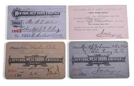
Four New York, West Shore & Buffalo Railroad Annual Passes - 1883, 1884, and 1885Rail & Road Auctions4.6(165)See Sold PriceMar 08, 2024
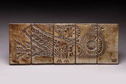
Roger CAPRON (1922-2006) : Pigeon. Cinq carreaux en céramique. Cachet de l'artiste en bas àValoir Pousse-Cornet4.3(4)See Sold PriceFeb 24, 2024
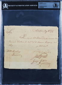
George Washington Signed 6x7.5 1787 Potomac Company Pay Order BAS SlabbedMynt Auctions4.6(680)See Sold PriceFeb 23, 2024
Map: An 18thC engraved and hand coloured map of North America and South America, titled DeClaydon Auctioneers Ltd4.3(125)See Sold PriceFeb 26, 2024
NORTH AFRICA. 'Biledulgerid', a former North African country. MALLET 1683 mapJasper524.5(9.8k)See Sold PriceFeb 28, 2024