ATLAS of ANTIENT GEOGRAPHY by SAMUEL BUTLER 1843John McInnis Auctioneers,LLC4.6(502)See Sold PriceFeb 24, 2024
18TH C. ANTIQUE MAP: FRENCH & INDIAN WAR, FRAMEDThomaston Place Auction Galleries4.4(386)See Sold PriceFeb 24, 2024
Rand McNally Railroad Map Cabinet w/ 21 Railroad MapsRail & Road Auctions4.6(165)See Sold PriceMar 08, 2024
Keith Haring - Ink on New York Map, Best Buddies, Inscribed, Signed, and DatedSapphire Auction Gallery4(67)See Sold PriceMar 02, 2024
LATE 17TH C. FRENCH MAP OF THE NEW WORLD BY ALEXIS-HUBERT JAILLOT (1632-1712)Thomaston Place Auction Galleries4.4(386)See Sold PriceFeb 24, 2024
Central Railroad of New Jersey Map of Sandy Hook Route-ca. 1903JM Hobby Supply and Railroad Artifact Auctions4.4(126)See Sold PriceFeb 24, 2024
Lot of Six Mixed Atlas Box Cars-HO Scale-New in BoxJM Hobby Supply and Railroad Artifact Auctions4.4(126)See Sold PriceFeb 25, 2024
Rand McNally/Santa Fe Railroad Map of Iowa-1912JM Hobby Supply and Railroad Artifact Auctions4.4(126)See Sold PriceFeb 24, 2024
NICOLAES VISSCHER (NETHERLANDS, 1618-1709) MAP OF THE NEW WORLDThomaston Place Auction Galleries4.4(386)See Sold PriceFeb 24, 2024
17TH C. WORLD MAP BY NICOLAES VISSCHER (NETHERLANDS, 1618-1709)Thomaston Place Auction Galleries4.4(386)See Sold PriceFeb 24, 2024
Lot of Six Mixed Atlas Cabooses-HO Scale-New in BoxJM Hobby Supply and Railroad Artifact Auctions4.4(126)See Sold PriceFeb 25, 2024
Descrittione dell' Isola di Metellino. PORCACCHI. Lesbos North Aegean 1590 mapTITLE/CONTENT OF MAP: Descrittione dell' Isola di Metellino [Description of the island of Lesbos] The map depicts the Greek North Aegean island of Lesbos. The map is orientated towards the north. DATESee Sold Price
"Descrittione dell' Isola di Metellino". PORCACCHI.TITLE/CONTENT OF MAP: 'Descrittione dell' Isola di Metellino [Description of the island of Lesbos]' The map depicts the Greek North Aegean island of Lesbos. The map is orientated towards the north. DASee Sold Price
Porcacchi: Antique Map of Lisland of Lesbos, 1595TITLE/CONTENT OF MAP: 'Descrittione dell' Isola di Metellino [Description of the island of Lesbos]' The map depicts the Greek North Aegean island of Lesbos. The map is orientated towards the north. DASee Sold Price
Descrittione dell' Isola Metellino. PORCACCHI. Lesbos North Aegean 1620 mapTITLE/CONTENT OF MAP: 'Descrittione dell' Isola Metellino [Description of the island of Lesbos]' The map depicts the Greek North Aegean island of Lesbos. The map is orientated towards the north. DATESee Sold Price
Descrittione dell' Isola di Lenno… PORCACCHI. Lemnos Limnos N. Aegean 1590 mapTITLE/CONTENT OF MAP: Descrittione dell' Isola di Lenno, hoggi detta Stalimene [Description of the island of Lemnos (Limnos)] The map depicts the Greek North Aegean island of Lemnos (Limnos). The mapSee Sold Price
Descrittione… Santa Croce Mondo Nuovo PORCACCHI North America New World 1590 mapTITLE/CONTENT OF MAP: Descrittione dell' Isola et Terra di Santa Croce, overo Mondo Nuovo [Description of North America or the New World] The map depicts the Scottish Hebrides & Orkney islands. The maSee Sold Price
Descrittione… Santa Croce Mondo Nuovo PORCACCHI North America New World 1590 mapTitle: Descrittione… Santa Croce Mondo Nuovo PORCACCHI North America New World 1590 map Description: Descrittione dell' Isola et Terra di Santa Croce, overo Mondo Nuovo [Description of North AmeSee Sold Price
Descrittione dell' Isola di Milo. PORCACCHI. Milos Cyclades Greece 1590 mapTITLE/CONTENT OF MAP: Descrittione dell' Isola di Milo [Description of the island of Milos] The map depicts the Greek Cycladic island of Milos. The map is orientated towards the north-north-west. DATESee Sold Price
Descrittione dell' Isola di Cerigo. PORCACCHI. Kythira Ionian Greece 1590 mapTITLE/CONTENT OF MAP: Descrittione dell' Isola di Cerigo [Description of the island of Kythira] The map depicts the Greek Ionian island of Kythira. The map is orientated towards the north-east. DATE PSee Sold Price
Descrittione dell' Isola di Cuba. PORCACCHI. Jamaica Hispaniola 1590 old mapTITLE/CONTENT OF MAP: Descrittione dell' Isola di Cuba [Description of the island of Cuba] The map depicts the Caribbean island of Cuba. The map is orientated towards the north. DATE PRINTED: 1590 IMASee Sold Price
Descrittione dell' Isola di Cuba. PORCACCHI. Jamaica Hispaniola 1590 old mapTITLE/CONTENT OF MAP: Descrittione dell' Isola di Cuba [Description of the island of Cuba] The map depicts the Caribbean island of Cuba. The map is orientated towards the north. DATE PRINTED: 1590 IMASee Sold Price
Descrittione dell' Isola di Cuba. PORCACCHI. Jamaica Hispaniola 1590 old mapTITLE/CONTENT OF MAP: Descrittione dell' Isola di Cuba [Description of the island of Cuba] The map depicts the Caribbean island of Cuba. The map is orientated towards the north. DATE PRINTED: 1590 IMASee Sold Price
Descrittione dell' Isola di Sicilia. PORCACCHI. Sicily Italy 1590 old mapTITLE/CONTENT OF MAP: Descrittione dell' Isola di Sicilia [Description of the island of Sicily] The map depicts the Italian Mediterranean island of Sicily. The map is orientated towards the north. DATSee Sold Price
Descrittione dell' Isola di Malta. PORCACCHI. Malta & Gozo 1590 old mapTITLE/CONTENT OF MAP: Descrittione dell' Isola di Malta [Description of the island of Malta] The map depicts the Scottish Hebrides & Orkney islands. The map is orientated towards the north. DATE PRINTSee Sold Price
Descrittione dell' Isola di Minorica. PORCACCHI. Minorca Menorca 1590 old mapTITLE/CONTENT OF MAP: Descrittione dell' Isola di Minorica [Description of the island of Minorca] The map depicts the Scottish Hebrides & Orkney islands. The map is orientated towards the north. DATESee Sold Price
Descrittione dell' Isola di Corfu. PORCACCHI. Ionian Greece 1590 old mapTITLE/CONTENT OF MAP: Descrittione dell' Isola di Corfu [Description of the island of Corfu] The map depicts the Greek Ionian island of Corfu. The map is orientated towards the north-east. DATE PRINTESee Sold Price
Descrittione dell' Isola di Cipro. PORCACCHI. Cyprus 1590 old antique mapTITLE/CONTENT OF MAP: Descrittione dell' Isola di Cipro [Description of the island of Cyprus] The map depicts the Scottish Hebrides & Orkney islands. The map is orientated towards the north. DATE PRINSee Sold Price
Descrittione dell' Isola di Candia. PORCACCHI. Crete 1590 old antique mapTITLE/CONTENT OF MAP: Descrittione dell' Isola di Candia [Description of the island of Crete] The map depicts the Scottish Hebrides & Orkney islands. The map is orientated towards the north. DATE PRINSee Sold Price
Descrittione dell' Isola di S. Lorenzo. PORCACCHI. Madagascar 1590 old mapTITLE/CONTENT OF MAP: Descrittione dell' Isola di S. Lorenzo [Description of the island of Madagascar] The map depicts the Scottish Hebrides & Orkney islands. The map is orientated towards the north.See Sold Price
Porcacchi: Antique Map of island of Chios, 1620TITLE/CONTENT OF MAP: 'Descrittione dell' Isola di Scio [Description of the island of Chios]' The map depicts the Greek North Aegean island of Chios. The map is orientated towards the east. DATE PRINTSee Sold Price
Descrittione dell' Isola di Sardigna. PORCACCHI. Sardinia Sardegna 1590 mapTITLE/CONTENT OF MAP: Descrittione dell' Isola di Sardigna [Description of the island of Sardinia] The map depicts the Italian Mediterranean island of Sardinia. The map is orientated towards the west.See Sold Price
Descrittione dell' Isola di Scarpanto PORCACCHI. Karpathos Dodecanese 1590 mapTITLE/CONTENT OF MAP: Descrittione dell' Isola di Scarpanto [Description of the island of Karpathos] The map depicts the Greek Dodecanese island of Karpathos. The map is orientated towards the south.See Sold Price
Descrittione dell' Isola di Corsica. PORCACCHI. France 1590 old antique mapTITLE/CONTENT OF MAP: Descrittione dell' Isola di Corsica [Description of the island of Corsica] The map depicts the French Mediterranean island of Corsica. The map is orientated towards the west. DATSee Sold Price
Descrittione dell' Isola di Gotlandia. PORCACCHI. Gotland Sweden 1590 old mapTITLE/CONTENT OF MAP: Descrittione dell' Isola di Gotlandia [Description of the island of Gotland] The map depicts the Swedish island of Gotland. The map is orientated towards the east. DATE PRINTED:See Sold Price
Central Railroad of New Jersey Map of Sandy Hook Route-ca. 1903JM Hobby Supply and Railroad Artifact Auctions4.4(126)See Sold PriceFeb 24, 2024
WILLEM JANSZOON BLAEU (NETHERLANDS, 1571-1638) MAP OF UMBRIAThomaston Place Auction Galleries4.4(386)See Sold PriceFeb 24, 2024
Westland Oil Company North Dakota Road MapCheck the Oil Promotions, LLC4.6(275)See Sold PriceFeb 25, 2024
Large lot of assorted prints. 18th-20th century. To include: North American and other maps, CivilTremont Auctions4.6(293)See Sold PriceFeb 25, 2024
Portfolio of 15 County Maps by Robert Morden (English 1650-1703)Nadeau's Auction Gallery4.7(401)See Sold PriceFeb 24, 2024
THE LAST CANNIBALS by JENS BJERRE 1957 Fine or Near FineNorth American Artifact Auctions4.6(182)See Sold PriceApr 20, 2024
Antique German Kampen Town Color Copper EtchingHill Auction Gallery 4.7(1k)See Sold PriceFeb 28, 2024
[ARCTIC]. BOWEN, Emanuel. A New & Accurate Map of the North...Potter & Potter Auctions4.6(539)See Sold PriceMar 07, 2024
Giovanni Battista Brustolon, After Canaletto, Procession of the Doge, 18th Century EngravingHoch LTD.4.5(73)See Sold PriceFeb 25, 2024
Arrowsmith & Lewis - Map of the United StatesTrillium Antique Prints & Rare Books4.5(30)See Sold PriceFeb 24, 2024
Carey, pub. 1796 - Map of the Tennassee State formerly part of North Carolina (Tennessee)Trillium Antique Prints & Rare Books4.5(30)See Sold PriceFeb 24, 2024
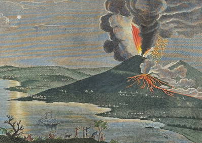
Filomarino - Mount Vesuvius Volcano Erupting. 6Trillium Antique Prints & Rare Books4.5(30)See Sold PriceFeb 24, 2024
Filomarino - Mount Vesuvius Volcano Erupting. 7Trillium Antique Prints & Rare Books4.5(30)See Sold PriceFeb 24, 2024
1822 MAP of NORTH & SOUTH AMERICA GEOGRAPHICAL STATISTICAL HISTORICAL antiqueJasper524.5(9.8k)See Sold PriceFeb 27, 2024
Herman Moll A New Map of Ye North Parts of AmericaWillow Auction House4.5(283)See Sold PriceMar 14, 2024


![[ARCTIC]. BOWEN, Emanuel. A New & Accurate Map of the North... (1 of 1)](https://p1.liveauctioneers.com/928/318880/171360917_1_x.jpg?height=282&quality=70&version=1707501302)