ATLAS of ANTIENT GEOGRAPHY by SAMUEL BUTLER 1843John McInnis Auctioneers,LLC4.6(502)See Sold PriceFeb 24, 2024
18TH C. ANTIQUE MAP: FRENCH & INDIAN WAR, FRAMEDThomaston Place Auction Galleries4.4(386)See Sold PriceFeb 24, 2024
Rand McNally Railroad Map Cabinet w/ 21 Railroad MapsRail & Road Auctions4.6(165)See Sold PriceMar 08, 2024
Keith Haring - Ink on New York Map, Best Buddies, Inscribed, Signed, and DatedSapphire Auction Gallery4(67)See Sold PriceMar 02, 2024
LATE 17TH C. FRENCH MAP OF THE NEW WORLD BY ALEXIS-HUBERT JAILLOT (1632-1712)Thomaston Place Auction Galleries4.4(386)See Sold PriceFeb 24, 2024
Central Railroad of New Jersey Map of Sandy Hook Route-ca. 1903JM Hobby Supply and Railroad Artifact Auctions4.4(126)See Sold PriceFeb 24, 2024
Lot of Six Mixed Atlas Box Cars-HO Scale-New in BoxJM Hobby Supply and Railroad Artifact Auctions4.4(126)See Sold PriceFeb 25, 2024
Rand McNally/Santa Fe Railroad Map of Iowa-1912JM Hobby Supply and Railroad Artifact Auctions4.4(126)See Sold PriceFeb 24, 2024
NICOLAES VISSCHER (NETHERLANDS, 1618-1709) MAP OF THE NEW WORLDThomaston Place Auction Galleries4.4(386)See Sold PriceFeb 24, 2024
17TH C. WORLD MAP BY NICOLAES VISSCHER (NETHERLANDS, 1618-1709)Thomaston Place Auction Galleries4.4(386)See Sold PriceFeb 24, 2024
Lot of Six Mixed Atlas Cabooses-HO Scale-New in BoxJM Hobby Supply and Railroad Artifact Auctions4.4(126)See Sold PriceFeb 25, 2024
IBERIA. Spain & Portugal showing regions. 'Espagne Moderne'. MALLET 1683 mapTITLE OF THE MAP: 'Espagne Moderne' (De L'Europe) DATE PRINTED: 1683 IMAGE SIZE: Approx Overall page size 13 x 21cm approximately (5 x 8 inches); image size 10.5 x 14.5cm approximately (4 x 5.5 inchesSee Sold Price
SoldMallet: Antique Map of Iberia, Spain & Portugal, 1683Title of the Map: 'Espagne Moderne' IBERIA. Spain & Portugal showing regions. Date Printed: 1683 Image Size: Approx Overall page size 13 x 21cm approximately (5 x 8 inches); image size 10.5 x 14.5cm aSee Sold Price
IBERIA. 'Espagne Moderne'. Spain & Portugal. Regions & towns. MALLET 1683 mapTITLE OF THE MAP: 'Espagne Moderne' (De L'Europe) DATE PRINTED: 1683 IMAGE SIZE: Approx Overall page size 26 x 21cm approximately (10 x 8 inches); image size 21 x 14.5cm approximately (8 x 5.5 inches)See Sold Price
Mallet: Antique Map of Spain & Portugal, 1683Title/Content of the Map: IBERIA. 'Espagne Moderne'. Spain & Portugal. Regions & towns Date Printed: 1683 Image Size: Approx Overall page size 26 x 21cm approximately (10 x 8 inches); image size 21 xSee Sold Price
ROMAN IBERIA 'Ancienne Espagne' Towns Hispania Lusitania Spain. MALLET 1683 mapTITLE OF THE MAP: 'Ancienne Espagne' (De L'Europe) DATE PRINTED: 1683 IMAGE SIZE: Approx Overall page size 26 x 21cm approximately (10 x 8 inches); image size 21 x 14.5cm approximately (8 x 5.5 inchesSee Sold Price
ANCIENT IBERIA. Roman provinces. Hispania Lusitania Spain Portugal 1683 mapTITLE OF THE MAP: 'Ancienne Espagne' (De L'Europe) DATE PRINTED: 1683 IMAGE SIZE: Approx Overall page size 13 x 21cm approximately (5 x 8 inches); image size 10.5 x 14.5cm approximately (4 x 5.5 incheSee Sold Price
Clouet: Map De L'Espagne Divisée par Provinces, 1750TITLE/CONTENT OF MAP: 'De L'Espagne Divisee par Provinces' A map of Iberia showing Spain dviided into Provinces, with Portugal DATE PRINTED: 1750 IMAGE SIZE: Approx 34.0 x 56.5cm, 13.5 x 22.25 inchesSee Sold Price
Mentelle/Chanlaire: Antique Map of Iberia, 1798TITLE/CONTENT OF MAP: 'Espagne Carte Comparative' A comparative map of Iberia showing river systems, the modern states of Spain and Portugal and the Roman provinces of Lusitania, Beatica & Hispania TaSee Sold Price
EGYPT. Nile valley showing towns & cities. 'Aegypte Moderne'. MALLET 1683 mapTITLE OF THE MAP: 'Aegypte Moderne' (De L'Afrique) DATE PRINTED: 1683 IMAGE SIZE: Approx Overall page size 13 x 21cm approximately (5 x 8 inches); image size 10.5 x 14.5cm approximately (4 x 5.5 incheSee Sold Price
GERMANY. Showing regions. 'Les dix cercles d'Allemagne'. MALLET 1683 old mapTITLE OF THE MAP: 'Les dix cercles d'Allemagne' (De L'Europe) DATE PRINTED: 1683 IMAGE SIZE: Approx Overall page size 13 x 21cm approximately (5 x 8 inches); image size 10.5 x 14.5cm approximately (4See Sold Price
PORTUGAL showing provinces towns rivers. Lisbon Porto Algarve. MALLET 1683 mapTITLE OF THE MAP: 'Portugal' (De L'Europe) DATE PRINTED: 1683 IMAGE SIZE: Approx Overall page size 13 x 21cm approximately (5 x 8 inches); image size 10.5 x 14.5cm approximately (4 x 5.5 inches) TYPE:See Sold Price
SoldVaugondy/Sanson: Antique Map of Ancient Iberia, 1750TITLE/CONTENT OF MAP: 'Hispania Antiqua in tres praecipuas partes, scilicet Tarraconensem, Lusitaniam, et Baeticam' A map of Ancient Iberia (Spain and Portugal) showing the Roman provinces of LusitaniSee Sold Price
Tardieu: Antique Map of Spain and Portugal, 1798TITLE/CONTENT OF MAP: 'Espagne et Portugal Carte Physique' A physical map of Iberia (Spain and Portugal) DATE PRINTED: c1798 IMAGE SIZE: Approx 36.5 x 47.0cm, 14.25 x 18.5 inches (Large); Please noteSee Sold Price
Perrot: Antique Map of Spain & Portufal, 1823Title of the Map: 'Espagne et Portugal' Spain and Portugal with decorative border - Iberia Date Printed: 1823 Image Size: Approx 14.0 x 17.5cm, 5.5 x 7 inches (Medium); Please note that this is a foldSee Sold Price
Perrot: Map of Espagne et Portugal, 1823TITLE OF THE MAP: 'Espagne et Portugal' Spain and Portugal with decorative border - Iberia This map is folding hence the centrefold line may show on the image below DATE PRINTED: 1823 IMAGE SIZE: ApprSee Sold Price
L'Espagne et le Portugal. Spain / Iberia. DESNOS/DE LATITLE/CONTENT OF MAP: 'L'Espagne et le Portugal, divisés par Gouvernemens généraux et provinces Ecclésiastiques. Par le Sr. Brion, Ingr Géogr. du Roi, à Paris, cher le Sr. Desnos, Ingr. Géog? PSee Sold Price
EUROPE. 'Europe Moderne'. Rivers countries. Very decorative. MALLET 1683 mapTITLE/CONTENT OF MAP: 'Part of Europe showing the boundaries of France and adjoining countries before the Revolution of 1789' DATE PRINTED: 1848 IMAGE SIZE: Approx 15.0 x 20.5cm, 5.75 x 8 inches (MediSee Sold Price
L'Espagne et le Portugal. Spain / Iberia. DESNOS/DE LATITLE/CONTENT OF MAP: 'L'Espagne et le Portugal, divisés par Gouvernemens généraux et provinces Ecclésiastiques. Par le Sr. Brion, Ingr Géogr. du Roi, à Paris, cher le Sr. Desnos, InSee Sold Price
Bonne: Antique Map of Spain Portugal, 1780TITLE/CONTENT OF MAP: 'Les Royaumes d'Espagne et de Portugal' A map of Iberia including Spain & Portugal DATE PRINTED: 1780 IMAGE SIZE: Approx 23.0 x 34.5cm, 9 x 13.5 inches (Large); Please note thatSee Sold Price
"Les Royaumes d'Espagne et de Portugal". Iberia SpainTITLE/CONTENT OF MAP: 'Les Royaumes d'Espagne et de Portugal' A map of Iberia including Spain & Portugal DATE PRINTED: 1780 IMAGE SIZE: Approx 23.0 x 34.5cm, 9 x 13.5 inches (Large); Please note thatSee Sold Price
"Les Royaumes d'Espagne et de Portugal". Iberia SpainTITLE/CONTENT OF MAP: 'Les Royaumes d'Espagne et de Portugal' A map of Iberia including Spain & Portugal Date: 1780 IMAGE SIZE: Approx 23.0 x 34.5cm, 9 x 13.5 inches (Large); Please note that this isSee Sold Price
Les Royaumes d'Espagne et de Portugal. Iberia SpainTITLE/CONTENT OF MAP: 'Les Royaumes d'Espagne et de Portugal' A map of Iberia including Spain & Portugal The top image on the right hand side shows the entire map. This map is folding hence the centreSee Sold Price
Royaumes d'Espagne et de Portugal.' by Rigobert Bonne.TITLE OF THE MAP: 'Royaumes d'Espagne et de Portugal' Kingdoms of Spain and Portugal - Iberia Date: 1780 IMAGE SIZE: Approx 24.5 x 36.0cm, 9.75 x 14 inches (Large); Please note that this is a foldingSee Sold Price
Desnos / de la Tour: Antique Map of Spain / Iberia 1771TITLE/CONTENT OF MAP: 'L'Espagne et le Portugal, divisés par Gouvernemens généraux et provinces Ecclésiastiques. Par le Sr. Brion, Ingr Géogr. du Roi, à Paris, cher le Sr. Desnos, Ingr. Géog? PSee Sold Price
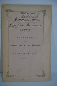
Boston and Maine RR Annual Report-September 12, 1849JM Hobby Supply and Railroad Artifact Auctions4.4(126)See Sold PriceFeb 24, 2024
Lake Superior and Mississippi River RR 1869 Seven Percent Bonds Book/Report-1869JM Hobby Supply and Railroad Artifact Auctions4.4(126)See Sold PriceFeb 24, 2024
Cincinnati Hamilton and Dayton RR Map -USGC 1889JM Hobby Supply and Railroad Artifact Auctions4.4(126)See Sold PriceFeb 24, 2024
Crams Railroad Map of New York-1881JM Hobby Supply and Railroad Artifact Auctions4.4(126)See Sold PriceFeb 24, 2024
Rock Island RR Iowa and Minnesota Lakes Country Brochure-1926JM Hobby Supply and Railroad Artifact Auctions4.4(126)See Sold PriceFeb 24, 2024
Union Pacific RR Across The Continent West From Omaha, NE Book-April 2, 1868JM Hobby Supply and Railroad Artifact Auctions4.4(126)See Sold PriceFeb 24, 2024
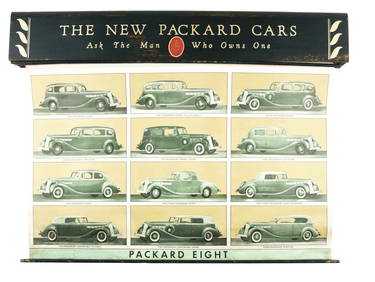
PACKARD MOTOR CARS DEALER SALES ROLL UP BANNERS.Dan Morphy Auctions4.2(1.3k)See Sold PriceFeb 24, 2024
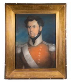
PERIOD PASTEL PORTRAIT OF AN UNIDENTIFIED GENERAL OFFICER, NAPOLEONIC WARS, 29TH FOOT, UNDERThomaston Place Auction Galleries4.4(386)See Sold PriceFeb 24, 2024
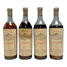
1933 Jose Maria Da Fronseca Camarate Collectors Bottles (4)Premier Auction Galleries4.3(329)See Sold PriceMar 09, 2024
Vintage County Map Of NY State Plate EngravingThe Benefit Shop Foundation Inc.4.3(2.9k)See Sold PriceFeb 28, 2024
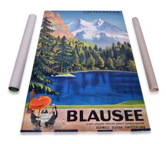
Three Switzerland and Spain Railway Advertising Travel PostersRail & Road Auctions4.6(165)See Sold PriceMar 07, 2024
Fred Harvey Railroad Souvenir Playing Cards - Indians and Train Smoke and Indians of the SouthwestRail & Road Auctions4.6(165)See Sold PriceMar 08, 2024
[ARCTIC]. BOWEN, Emanuel. A New & Accurate Map of the North...Potter & Potter Auctions4.6(539)See Sold PriceMar 07, 2024
ANDREW RAYMOND JANSON OIL ON BOARD ADIRONDACKSCharleston Estate Services Ltd.4.5(58)See Sold PriceMar 03, 2024
Willem Blaeu, Etc. 17th C. Antiquarian Maps, 2Auctions at Showplace4.5(726)See Sold PriceMar 17, 2024
Carey, pub. 1796 - Map of KentuckyTrillium Antique Prints & Rare Books4.5(30)See Sold PriceFeb 24, 2024
Carey, pub. 1796 - Map of the Tennassee State formerly part of North Carolina (Tennessee)Trillium Antique Prints & Rare Books4.5(30)See Sold PriceFeb 24, 2024
Herman Moll A New Map of Ye North Parts of AmericaWillow Auction House4.5(283)See Sold PriceMar 14, 2024


![[ARCTIC]. BOWEN, Emanuel. A New & Accurate Map of the North... (1 of 1)](https://p1.liveauctioneers.com/928/318880/171360917_1_x.jpg?height=282&quality=70&version=1707501302)


