ATLAS of ANTIENT GEOGRAPHY by SAMUEL BUTLER 1843John McInnis Auctioneers,LLC4.5(505)See Sold PriceFeb 24, 2024
18TH C. ANTIQUE MAP: FRENCH & INDIAN WAR, FRAMEDThomaston Place Auction Galleries4.4(393)See Sold PriceFeb 24, 2024
Rand McNally Railroad Map Cabinet w/ 21 Railroad MapsRail & Road Auctions4.6(165)See Sold PriceMar 08, 2024
Keith Haring - Ink on New York Map, Best Buddies, Inscribed, Signed, and DatedSapphire Auction Gallery4.1(67)See Sold PriceMar 02, 2024
LATE 17TH C. FRENCH MAP OF THE NEW WORLD BY ALEXIS-HUBERT JAILLOT (1632-1712)Thomaston Place Auction Galleries4.4(393)See Sold PriceFeb 24, 2024
Central Railroad of New Jersey Map of Sandy Hook Route-ca. 1903JM Hobby Supply and Railroad Artifact Auctions4.4(127)See Sold PriceFeb 24, 2024
Lot of Six Mixed Atlas Box Cars-HO Scale-New in BoxJM Hobby Supply and Railroad Artifact Auctions4.4(127)See Sold PriceFeb 25, 2024
Rand McNally/Santa Fe Railroad Map of Iowa-1912JM Hobby Supply and Railroad Artifact Auctions4.4(127)See Sold PriceFeb 24, 2024
NICOLAES VISSCHER (NETHERLANDS, 1618-1709) MAP OF THE NEW WORLDThomaston Place Auction Galleries4.4(393)See Sold PriceFeb 24, 2024
17TH C. WORLD MAP BY NICOLAES VISSCHER (NETHERLANDS, 1618-1709)Thomaston Place Auction Galleries4.4(393)See Sold PriceFeb 24, 2024
Lot of Six Mixed Atlas Cabooses-HO Scale-New in BoxJM Hobby Supply and Railroad Artifact Auctions4.4(127)See Sold PriceFeb 25, 2024
Mortier & Jaillot Map of The Red SeaMORTIER, Pieter (1661-1711), after JAILLOT, Alexis-Hubert (1632-1712). Carte Particuliere de la Mer Rouge &c. Leve par Ordre Expres des Roys de Portugal sous qui on en a Fait la Decouverte. Engraved mSee Sold Price
MAP, Arabia, Red Sea, East Africa, JaillotArabia, Red Sea, East Africa. Jaillot/Mortier, Carte Particuliere de la Mer Rouge &c. Leve par Ordre Expres des Roys de Portugal sous qui on en a Fait la Decouverte, 1700 (circa). Hand Color. This bolSee Sold Price
MAP - Arabia, Red Sea. Jaillot/MortierArabia, Red Sea, East Africa. Jaillot/Mortier, Carte Particuliere de la Mer Rouge &c. Leve par Ordre Expres des Roys de Portugal sous qui on en a Fait la Decouverte, 1700 (circa). Hand Color. This bolSee Sold Price
MAP, Red Sea, MortierRed Sea. Pierre Mortier, Carte des Principales Ports de Mer Bancs de Sable, &c: qui sont dans la Mer Rouge..., from Neptune Francais, 1720 (circa). Hand Color. The bays and safe anchorages in the RedSee Sold Price
Map or Red Sea & adjacent areas 1720Heading: (Middle East - Red Sea) Author: Mortier, Pierre Title: Carte Particuliere de la Mer Rouge &c. Place Published: Amsterdam Publisher: Date Published: 1720 Description:See Sold Price
SoldAntique Map: RED SEA: KARTE DES ARABISCHEN MEERBUSENSMap with original decorative colour in outline shows the Red Sea. With an in-set map of the Gulf of Suez. Marked are towns, cities ports and smaller regions.The author Carsten Niebuhr (1733 - 1815) waSee Sold Price
Mortier & Jaillot Map of the Chesapeake BayMORTIER, Pierre (1661-1711), After JAILLOT, Alexis-Hubert (1632-1712). Carte Particuliere de Virginie, Maryland, Pennslyvanie, La Nouvelle Jarsey. . . Engraved map with original hand color in full. AmSee Sold Price
SoldMAP, Red Sea, LangenesRed Sea. Barent Langenes, Mare Rubrum, from Thresor de Chartes, 1600 (published). Hand Color. This miniature map centers on the Red Sea and spans from Suez down to Zaila in present-day Somalia. It feaSee Sold Price
MAP, Red Sea, LangenesRed Sea. Barent Langenes, Mare Rubrum, from Thresor de Chartes, 1600 (published). Hand Color. This miniature map centers on the Red Sea and spans from Suez down to Zaila in present-day Somalia. It feaSee Sold Price
Soldd'Anville: Antique Map of the Red Sea & Islands, 1789Map: Red Sea & It's Islands Date Printed: 1789 Cartographer: Harrison D' Anville Material/Medium: Paper Size: 15" x 21" Condition: Very Good. Small tear on top. Tear does not affect the Map. Printed iSee Sold Price
Red Sea. Bab-el-Mandeb strait.Admiralty nautical seaReserve Reduced! TITLE/CONTENT OF MAP: 'Red Sea - Jebel Teir to Perim Island' DATE: Surveyed 1877-1919; Published 1882; Revised to 1930 IMAGE SIZE: Approx 91.5 x 100.5cm, 36 x 39.75 inches (Large); PlSee Sold Price
Admiralty nautical sea chart of the Red Sea, 1930TITLE/CONTENT OF MAP: 'Red Sea - Jebel Teir to Perim Island' DATE PRINTED: Surveyed 1877-1919; Published 1882; Revised to 1930 IMAGE SIZE: Approx 91.5 x 100.5cm, 36 x 39.75 inches (Large); Please noteSee Sold Price
Red Sea. Jebel Teir - Perim Island nautical chart 1930TITLE/CONTENT OF MAP: 'Red Sea - Jebel Teir to Perim Island' DATE PRINTED: Surveyed 1877-1919; Published 1882; Revised to 1930 IMAGE SIZE: Approx 91.5 x 100.5cm, 36 x 39.75 inches (Large); Please noteSee Sold Price
Red Sea. Jebel Teir Perim Island. Admiralty nauticalTITLE/CONTENT OF MAP: 'Red Sea - Jebel Teir to Perim Island' DATE PRINTED: Surveyed 1877-1919; Published 1882; Revised to 1930 IMAGE SIZE: Approx 91.5 x 100.5cm, 36 x 39.75 inches (Large); Please noteSee Sold Price
Bertius: Antique Map of the Red Sea, 1600Title: Mare Rubrum. Small 1600 map of the Red Sea with Egypt, Sudan, Saudi Arabia and Yemen Map maker: Petrus Bertius, Cornelium Nicolai Place and Year: Amsterdam, 1600 Dimensions: 11.5 x 16 cm (4.5 xSee Sold Price
SoldBellin: Antique Map of Arabia & Red Sea, 1728Map: 1728 Bellin Map of Arabia and Red Sea -- Carte de la Coste d'Arabie, Mer Rouge, et Golfe de Perse Cartographer: J Bellin Year / Place: 1740, Paris Dimensions: 8.6 x 9.8 in. Condition: Very good.See Sold Price
D'Anville: French Chart Map of the Red Sea, 1765Title: Golfe Arabique ou Mer Rouge...(French Chart of the Red Sea) Map maker: Jean Baptiste Bourguignon d'Anville Place and Year: Paris, 1765 Dimensions: 48.3 x 67 cm (19 x 26.4 in) Technique: CopperpSee Sold Price
1764 Bellin Map of the Red Sea Region -- Carte de laTitle/Content of Map: 1764 Bellin Map of the Red Sea Region -- Carte de la Mer Rouge et Partie de L'Arabie Date: 1764, Paris Cartographer: J Bellin Size: 8.5 X 14.2 in. This is a quite nice map of theSee Sold Price
1764 Bellin Map of the Red Sea Region -- Carte de laTitle/Content of Map: 1764 Bellin Map of the Red Sea Region -- Carte de la Mer Rouge et Partie de L'Arabie Date: 1764, Paris Cartographer: J Bellin Size: 8.5 X 14.2 in. This is a quite nice map of theSee Sold Price
Dudley Map of the Red SeaDudley, Robert (1532-1588). [Red Sea] Carta particolare...Baduis e finisce con il capo Cumana, e mostra la bocca dell mare Rosso. Engraved map. Florence: Onofri, 1646-47. 20 7/8” x 31 1/2” sheet.See Sold Price
Bonne: Map of Arabia, Red Sea & Persian Gulf, 1780Title/Content of Map: 'Carte de L'Arabie, du Golfe Persique et de la Mer Rouge, avec l'Egypte, la Nubie et l'Abissinie' A map of Arabia, the Nile valley & Abyssinia, with the Red Sea and Persian GulfSee Sold Price
1764 Bellin Map of the Red Sea Region -- Carte de laTitle/Content of Map: 1764 Bellin Map of the Red Sea Region -- Carte de la Mer Rouge et Partie de L'Arabie Date: 1764, ParisCartographer: J Bellin Size: 8.5 X 14.2 in. This is a quite nice map of theSee Sold Price
Hall: Antique Map of Egypt, Red Sea Nile, 1829TITLE/CONTENT OF MAP: 'Egypt' This fascinating map covers Egypt and the Red Sea including the Gulf of Aqaba and the Gulf of Suez. Tiran and Sanafir Islands are marked as "Pirates Isles". The town of ASee Sold Price
1764 Bellin Map of the Red Sea Region -- Carte de laTitle/Content of Map: 1764 Bellin Map of the Red Sea Region -- Carte de la Mer Rouge et Partie de L'Arabie Date: 1764, Paris Cartographer: J Bellin Size: 8.5 X 14.2 in. This is a quite nice map of theSee Sold Price
LARGE LATE 17TH C. DUTCH CHART OF CANADA, GREAT LAKES, NEW FRANCE, LABRADOR, HUDSON BAY, BY PIERREThomaston Place Auction Galleries4.4(393)See Sold PriceFeb 24, 2024
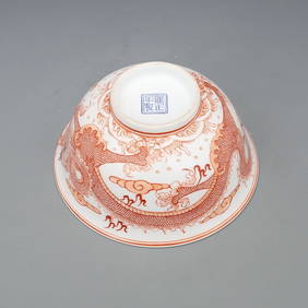
Qing Dynasty Yongzheng alum red sea dragon pattern skimming bowl Height 7.00CM diameter 13.80CMFind Treasure4.1(15)See Sold PriceApr 07, 2024
BLUE AND WHITE UNDERGLAZED RED SEA DRAGON PATTERN PLUM VASEMega International Auction4.3(62)See Sold PriceFeb 24, 2024
BLUE AND WHITE UNDERGLAZED RED SEA WATER CLOUD DRAGON PATTERN CELESTIAL SPHERE BOTTLEMega International Auction4.3(62)See Sold PriceFeb 24, 2024
Collared Kingfisher Articulated Bird Skelton TaxidermyCircle M Auctions4.6(116)See Sold PriceMar 16, 2024
The Red Sea, Large copper painted in oil from the 17th century, attributable to the workshop orTemplum Fine Art Auctions4.3(8)See Sold PriceFeb 28, 2024
William Simpson's Sketches at the Seat of War - Two Volumes with 81 Hand-colored LithographsTrillium Antique Prints & Rare Books4.5(32)See Sold PriceFeb 24, 2024
La Nubia ed Abissinia. Red Sea Ethiopia Sudan Eritrea Arabia. ZATTA 1785 mapJasper524.5(9.9k)See Sold PriceFeb 28, 2024
Vintage Rolex 1665 Double Red Sea Dweller Stainless SteelGolden Gate Auctioneer4.1(278)See Sold PriceFeb 29, 2024
Stanford, Edward 1901 Large Map. Sea of Marmara. TurkeyAlbion Auctions4.7(341)See Sold PriceMar 01, 2024
4 English Herge The Adventures Of Tintin Softcover Comics BRapid Estate Liquidators and Auction Gallery4.5(1.1k)See Sold PriceFeb 27, 2024
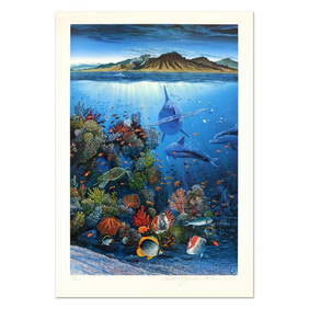
Robert Lyn Nelson, "Red Sea Sirens" Limited Edition Mixed Media, Numbered and Hand Signed withRobinhood Auctions4.7(794)See Sold PriceMar 03, 2024
Vintage Rolex 1665 Double Red Sea Dweller Stainless SteelPacific Global Auction3.9(280)See Sold PriceFeb 25, 2024