Sold(MAP) MARTINELLI, AGOSTINO. [Rome, c. 1672].(MAP) MARTINELLI, AGOSTINO Veduta dei Piani di Magliano e dei Piani di Gallese. [Rome, c. 1672] Engraved map. Five vertical folds; 2-inch tear at center; four small wormholes; light foxing. 14 3/4 x 2See Sold Price
Lafreri Map of St. Thomas off the coast of AfricaLAFRERI, Antonio (1512-1577). L'Isola de S. Thome. Engraved map. Rome, c. 1560's. 6 1/4" x 5 1/2" sheet, 17 3/4" x 17" framed. Early engraved map of the Islands off the coast of Africa.See Sold Price
SoldMap by Homann, Imperial Rome, c. 1720Historic Mapsc. 1720, SAC. ROM. IMPERII PRINCIPATUS & EPISCOPATUS BAMBERGENSIS NOVA TABULA GEOGRAPHICA, by Homann, Nuremberg, Very Fine. 19” x 22.25”, Original hand color. Elaborate, detaiSee Sold Price
SoldMap by Homann, Imperial Rome, c. 1720Mapsc. 1720, SAC. ROM. IMPERII PRINCIPATUS & EPISCOPATUS BAMBERGENSIS NOVA TABULA GEOGRAPHICA, by Homann, Nuremberg, Very Fine. 19” x 22.25”, Original hand color. Elaborate, detailed map wSee Sold Price
SoldMap by Homann, Imperial Rome, c. 1720Historic Mapsc. 1720, SAC. ROM. IMPERII PRINCIPATUS & EPISCOPATUS BAMBERGENSIS NOVA TABULA GEOGRAPHICA, by Homann, Nuremberg, Very Fine. 19" x 22.25", Original hand color. Elaborate, detailedSee Sold Price
SoldMap by Homann, Imperial Rome, c. 1720Mapsc. 1720, SAC. ROM. IMPERII PRINCIPATUS & EPISCOPATUS BAMBERGENSIS NOVA TABULA GEOGRAPHICA, by Homann, Nuremberg, Very Fine. 19” x 22.25”, Original hand color. Elaborate, detailed map wSee Sold Price
SoldMap by Homann, Imperial Rome, c. 1720Mapsc. 1720, SAC. ROM. IMPERII PRINCIPATUS & EPISCOPATUS BAMBERGENSIS NOVA TABULA GEOGRAPHICA, by Homann, Nuremberg, Very Fine. 19” x 22.25”, Original hand color. Elaborate, detailed map wSee Sold Price
SoldMap by Homann, Imperial Rome, c. 1720Historic Mapsc. 1720, Map Entitled: SAC. ROM. IMPERII PRINCIPATUS & EPISCOPATUS BAMBERGENSIS NOVA TABULA GEOGRAPHICA, by Homann, Nuremberg, Very Fine. 19" x 22.25", Original hand color. ElaborSee Sold Price
SoldMap by Homann, Imperial Rome, c. 1720Mapsc. 1720, SAC. ROM. IMPERII PRINCIPATUS & EPISCOPATUS BAMBERGENSIS NOVA TABULA GEOGRAPHICA, by Homann, Nuremberg, Very Fine. 19” x 22.25”, Original hand color. Elaborate, detailed map wSee Sold Price
SoldMap by Homann, Imperial Rome, c. 1720Mapsc. 1720, SAC. ROM. IMPERII PRINCIPATUS & EPISCOPATUS BAMBERGENSIS NOVA TABULA GEOGRAPHICA, by Homann, Nuremberg, Very Fine. 19” x 22.25”, Original hand color. Elaborate, detailed map wSee Sold Price
17th/18th c Map of Rome by Christoph Weigelins17th/18th c Map of Rome by Christoph Weigelins, hand tinted print, labeled in latin, matted and framed. Appx 12 1/2" x 17 1/4" viewed, frame 19" x 24". Good condition with some discoloration in the upSee Sold Price
SoldGiovanni Battista Piranesi (Italian, 1720-1778)Giovanni Battista Piranesi (Italian, 1720-1778), "Pianta di Roma e del Campo Marzio", c. 1774, Rome, engraved map on three joined sheets, folded, 53 in. x 30 3/8 in., WE 1008, watermark Robison 36See Sold Price
SoldWillem Janszoon Blaeu /C. Mortie Map of RomeFine example of Joan Blaeu's plan of Rome, from Blaeu's Theatrum civitatum et admirandorum Italiae, first published in 1663.The present edition, re-issued by Mortier, includes a grid pattern, added toSee Sold Price
SoldMAP OF ANTIQUE ROME - ANTEIQVAVE VRBIS IMAGO, c.MAP OF ANTIQUE ROME - ANTEIQVAVE VRBIS IMAGO c. 1700 Colored etching Image size: 13 1/4 x 17 5/8 in. Frame size: 19 3/4 x 24 1/4 in.See Sold Price
SoldNicolas Sanson, 17th c. map of Imperial RomeNicolas Sanson, 17th c. map of Imperial Rome, Nicolas Sanson (French, 1600-1667), "Imperii Romani geographica descriptio ad Herodiani historiam", c. 1650, Roman territory throughout Europe and Asia asSee Sold Price
SoldWater Color and Print Grouping Water color of fishermanWater color of fisherman in the bay. Good color, no foxing. Image measures approx 5"h x 21"w. Also a 19th C woodcut printed map of Rome.See Sold Price
J.WEIGEL(*1654), City map of ancient Rome with itsJohann Christoph Weigel (1654 Redwitz - 1725 Nürnberg), City map of ancient Rome with its seven hills, c. 1720, Colored Copper Engraving Technique: Colored copper engraving on paper Size: 12 1/2See Sold Price
SoldFramed 18th C. French Map of Ancient Rome**First Time At Auction** Louis Brion de la Tour (French, 1743-1810) & Louis Charles Desnos (French, 1725-1805), "Suite De L'Histoire De Rome", ca. 1760 to 1770. Copperplate engraved with original hanSee Sold Price
SoldClaudio Ducheti. Hierusalem. Rome, c. 1600.Map of modern Jerusalem. Later edition of Claudio Ducheti published by Henricus Van Schoel. (First printed in Vienna in 1570 by Ducheti). Rome, c. 1600. Latin. 42x30 cm., inclusive – 44.5x33.5 cm. FSee Sold Price
Map of the Low Countries by Nicolo Sansonepublished by Rossi in "Mercurio Geografico guida Geografico in Tute le Parte del Mondo, etc." Rome, 1672. Small stain upper right, minor scattered stains, center crease. Framed, not examined out of frSee Sold Price
Map of the Holy Land. Cigni Julius Cesare. Rome? C.Carta topographica judaeae quae complectitur ea loca tantum quorum mentio fit in evangelio. Map of the Holy Land divided into provinces. Miniature inset map of Jerusalem and its environs at top right.See Sold Price
SoldLot of three vintage maps1, Lot of three vintage maps department of archives in history 1966 parts of South Carolina Collet 1770, 2, Virginia white-De Bry 1590, 3, the Apalathean. Mountains, Ogilby c. 1672See Sold Price
SoldTHREE MAPS BY NICHOLAS SANSON D'ABBEVILLE. - 16 xTHREE MAPS BY NICHOLAS SANSON D'ABBEVILLE. Audience de Mexico"; "Audience de Guatemala"; and "Provincie Unite de Paesi Bassi", published by Rossi, Rome, 1672. Engravings with hand-coloring - 16 x 19 1See Sold Price
SoldDuchetti, Map of Africa, 1579DUCHETTI, Claudio (active c.1565-c.1579). Il disegno della Geographica moderna de tutta la parte' dell Africa.Engraved map. Rome, 1579. 19 1/8" x 24 3/4" sheet; 30 1/2" x 36" framed. An extremely rareSee Sold Price
17TH C. WORLD MAP BY NICOLAES VISSCHER (NETHERLANDS, 1618-1709)Thomaston Place Auction Galleries4.4(386)See Sold PriceFeb 24, 2024
LATE 17TH C. FRENCH MAP OF THE NEW WORLD BY ALEXIS-HUBERT JAILLOT (1632-1712)Thomaston Place Auction Galleries4.4(386)See Sold PriceFeb 24, 2024
17TH C. ANTIQUE MAP SIEGE OF LA ROCHELLE, FRANCE, FRAMEDThomaston Place Auction Galleries4.4(386)See Sold PriceFeb 24, 2024
EARLY 18TH C. MAP OF ITALY, FRAMEDThomaston Place Auction Galleries4.4(386)See Sold PriceFeb 24, 2024
LATE 16TH C. MAP OF SCOTLAND BY MERCATOR, FRAMEDThomaston Place Auction Galleries4.4(386)See Sold PriceFeb 24, 2024
17TH C. MAP OF THE BERKSHIRES BY JOHN SPEED, FRAMEDThomaston Place Auction Galleries4.4(386)See Sold PriceFeb 24, 2024
18TH C. ANTIQUE MAP: FRENCH & INDIAN WAR, FRAMEDThomaston Place Auction Galleries4.4(386)See Sold PriceFeb 24, 2024
17TH C. ENGLISH LINEAR MAP BY OGILBY, FRAMEDThomaston Place Auction Galleries4.4(386)See Sold PriceFeb 24, 2024
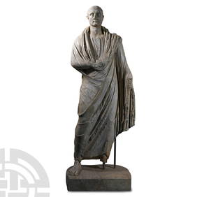
Roman Life-Size Marble Statue of an Important MagistrateTimeLine Auctions Ltd.4.5(183)See Sold PriceMar 05, 2024
Johann Homann Hand-Colored Map Engraving, c. 1730Auctions at Showplace4.5(726)See Sold PriceMar 17, 2024
Willem Blaeu, Etc. 17th C. Antiquarian Maps, 2Auctions at Showplace4.5(726)See Sold PriceMar 17, 2024
Two (2) Antique 18th C. Copper Engraved Framed Maps - America & EuropeMagnusson Art Group4.5(46)See Sold PriceMar 14, 2024
A quantity of World War II / Two military ephemera to include assorted 1940s newspapers pages toClaydon Auctioneers Ltd4.3(125)See Sold PriceFeb 26, 2024
Perry, Matthew C. 1856 Large Map. Shah Bay, Lew Chew I. JapanAlbion Auctions4.6(336)See Sold PriceMar 01, 2024
SCIENCE, MEMORY, NATURE. 12 BOOKS SOLD TOGETHERToronto Book Auctions4.3(13)See Sold PriceMar 07, 2024
![(MAP) MARTINELLI, AGOSTINO. [Rome, c. 1672]. First Image](https://p1.liveauctioneers.com/197/30916/12134082_1_x.jpg?height=282&quality=95&version=1342619735&width=282)
![(MAP) MARTINELLI, AGOSTINO. [Rome, c. 1672]. (1 of 1)](https://p1.liveauctioneers.com/197/30916/12134082_1_x.jpg?height=282&quality=70&version=1342619735)
![(MAP) MARTINELLI, AGOSTINO. [Rome, c. 1672]. First Image](https://p1.liveauctioneers.com/197/30916/12134082_1_x.jpg?height=282&quality=1&version=1342619735&width=282)