ATLAS of ANTIENT GEOGRAPHY by SAMUEL BUTLER 1843John McInnis Auctioneers,LLC4.6(502)See Sold PriceFeb 24, 2024
18TH C. ANTIQUE MAP: FRENCH & INDIAN WAR, FRAMEDThomaston Place Auction Galleries4.4(386)See Sold PriceFeb 24, 2024
Rand McNally Railroad Map Cabinet w/ 21 Railroad MapsRail & Road Auctions4.6(165)See Sold PriceMar 08, 2024
Keith Haring - Ink on New York Map, Best Buddies, Inscribed, Signed, and DatedSapphire Auction Gallery4(67)See Sold PriceMar 02, 2024
LATE 17TH C. FRENCH MAP OF THE NEW WORLD BY ALEXIS-HUBERT JAILLOT (1632-1712)Thomaston Place Auction Galleries4.4(386)See Sold PriceFeb 24, 2024
Central Railroad of New Jersey Map of Sandy Hook Route-ca. 1903JM Hobby Supply and Railroad Artifact Auctions4.4(126)See Sold PriceFeb 24, 2024
Lot of Six Mixed Atlas Box Cars-HO Scale-New in BoxJM Hobby Supply and Railroad Artifact Auctions4.4(126)See Sold PriceFeb 25, 2024
Rand McNally/Santa Fe Railroad Map of Iowa-1912JM Hobby Supply and Railroad Artifact Auctions4.4(126)See Sold PriceFeb 24, 2024
NICOLAES VISSCHER (NETHERLANDS, 1618-1709) MAP OF THE NEW WORLDThomaston Place Auction Galleries4.4(386)See Sold PriceFeb 24, 2024
17TH C. WORLD MAP BY NICOLAES VISSCHER (NETHERLANDS, 1618-1709)Thomaston Place Auction Galleries4.4(386)See Sold PriceFeb 24, 2024
Lot of Six Mixed Atlas Cabooses-HO Scale-New in BoxJM Hobby Supply and Railroad Artifact Auctions4.4(126)See Sold PriceFeb 25, 2024
1640 c. Blaeu Map of Northeast Italy Centered on UrbinoTitle: 1640 c. Blaeu Map of Northeast Italy Centered on Urbino -- rom this remarkable and decorative atlas Cartographer: Blaeu [family] Year / Place: 1640 c., Amsterdam Map Dimension (in.): 15 X 19.6See Sold Price
1640 c. Blaeu Map of Northeast Italy Centered on UrbinoTitle: 1640 c. Blaeu Map of Northeast Italy Centered on Urbino -- rom this remarkable and decorative atlas Cartographer: Blaeu [family] Year / Place: 1640 c., Amsterdam Map Dimension (in.): 15 X 19.6See Sold Price
1640 c. Blaeu Map of Northeast Italy Centered on Urbino -- rom this remarkable and decorative atlasTitle: 1640 c. Blaeu Map of Northeast Italy Centered on Urbino -- rom this remarkable and decorative atlas Cartographer: Blaeu [family] Year / Place: 1640 c., Amsterdam Map Dimension (in.): 15 X 19.6See Sold Price
1640 c. Blaeu Map of Northeast Italy Centered on Urbino -- Ducato di UrbinoTitle: 1640 c. Blaeu Map of Northeast Italy Centered on Urbino -- Ducato di Urbino Cartographer: Blaeu [family] Year / Place: 1640 c., Amsterdam Map Dimension (in.): 15 X 19.6 in. This is a lovely douSee Sold Price
1640 c. Blaeu Map of Northeast Italy Centered on UrbinoTitle: 1640 c. Blaeu Map of Northeast Italy Centered on Urbino -- rom this remarkable and decorative atlas Cartographer: Blaeu [family] Year / Place: 1640 c., Amsterdam Map Dimension (in.): 15 X 19.6See Sold Price
SoldJ. Blaeu map of ItalyCartographer: Joan Blaeu Title: Ducato di Parma et di Piacenza Subject: Italy Published: Amsterdam: Schenk and Valck Date: 1640 - c. 1700 Description: Baroque-style cartouches embellish this map encomSee Sold Price
SoldJ. Blaeu map of ItalyCartographer: Joan Blaeu Title: Ducato di Parma et di Piacenza Subject: Italy Published: Amsterdam: Schenk and Valck Date: 1640 - c. 1700 Description: Baroque-style cartouches embellish this map encomSee Sold Price
SoldMap of southern Italy by Blaeu, c.1640Heading: Author: Blaeu, Willem Title: Terra di Otranto olim Salentina et Iapigia Place Published: Amsterdam Publisher: Date Published: c.1640 Description: Copper-engraved mSee Sold Price
SoldMap, c. 1640, Northeast SpainMapsc. 1640, ARAGONIA REGNVM, by Blaeu, [Amsterdam], Choice Very Fine. 16.25” x 20.5”, copper-engraved map with early hand coloring. Showing the northeast region of Spain, which was a kingSee Sold Price
SoldMap of Milan region Italy 1640Heading: Author: Blaeu, Willem Title: Stato di Milano Place Published: Amsterdam Publisher: Date Published: c.1640 Description: Copper-engraved map, hand-colored in outline; colSee Sold Price
Map of Milan region Italy 1640Heading: Author: Blaeu, Willem Title: Stato di Milano Place Published: Amsterdam Publisher: Date Published: c.1640 Description: Copper-engraved map, hand-colored in outlineSee Sold Price
Bologna region in northern ItalyHeading: Author: Blaeu, Willem Title: Territorio di Bologna Place Published: Amsterdam Publisher: Date Published: c.1640 Description: Copper-engraved map, hand-colored. 44xSee Sold Price
SoldBlaeu. Calabria Citra olim Magna Graecia. c.1640.[Italy] Blaeu, Willem. “Calabria Citra olim Magna Graecia.” Amsterdam, c.1640. Engraved map. 19 3/8” x 15”. Verso blank. Hand-colored. Two colored cartouches. 4 cities marked iSee Sold Price
SoldBologna region in northern ItalyHeading: Author: Blaeu, Willem Title: Territorio di Bologna Place Published: Amsterdam Publisher: Date Published: c.1640 Description: Copper-engraved map, hand-colored. 44x54 cmSee Sold Price
Sold18th c Map - Italy Ducato de Urbinofrom an 18th c Atlas possibly Dutch engraved and hand colored framed & glazedSee Sold Price
SoldGuiljelmum Blaeu Map, Copper Engraving, c. 1640[Blaeu Map of Burgundy], "Utriusque Burgundiae, tum Ducatus tum Comitalus", by Guiljelmum Blaeu, Amsterdam, c. 1640, copper engraving, later color, framed and matted, lacking glass * NO RETURNS ARE ACSee Sold Price
SoldGuiljelmus Blaeu Map of the Caribbean, c. 1640Property of a Private Collection, Savannah, GA (Dutch, 1571-1638), Titled 'Insulae American AE in Oceano Septentrionali', matted and framed. Frame size: 21 1/2 in. x 25 1/4 in. By sight: H. 14 3/4 in.See Sold Price
Sold1640 Blaeu Map of the Spice Islands -- Moluccae InsulaeTitle/Content of Map: 1640 Blaeu Map of the Spice Islands -- Moluccae Insulae Celeberrimae Date Printed: 1640 c., Amsterdam Cartographer: Hondius / Blaeu Size: 14.8 x 19.4 in. A very nice map of the SSee Sold Price
1640 Blaeu Map of Dutch Groningen -- Groninga DominiumTitle: 1640 Blaeu Map of Dutch Groningen -- Groninga Dominium Cartographer: Blaeu [family] Year / Place: 1640 c., Amsterdam Map Dimension (in.): 14.8 X 19.3 in. This is a lovely double-page map of theSee Sold Price
Sold1640 Blaeu Map of Dutch Groningen -- Groninga DominiumTitle: 1640 Blaeu Map of Dutch Groningen -- Groninga Dominium Cartographer: Blaeu [family] Year/Place: 1640 c., Amsterdam Dimensions: 14.8 X 19.3 in. Description: This is a lovely double-page map of tSee Sold Price
1640 Blaeu Map of Sicily -- Sicilia regnumTitle: 1640 Blaeu Map of Sicily -- Sicilia regnum Cartographer: W Baeu Year / Place: 1640 c., Amsterdam Map Dimension (in.): 14.9 X 19.5 in. This is a strikingly attractive larger map of the Kingdom oSee Sold Price
1640 Blaeu Map of Dutch Groningen -- Groninga DominiumTitle: 1640 Blaeu Map of Dutch Groningen -- Groninga Dominium Cartographer: Blaeu [family] Year / Place: 1640 c., Amsterdam Map Dimension (in.): 14.8 X 19.3 in. This is a lovely double-page map of theSee Sold Price
1640 Blaeu Map of Dutch Groningen -- Groninga DominiumTitle: 1640 Blaeu Map of Dutch Groningen -- Groninga Dominium Cartographer: Blaeu [family] Year / Place: 1640 c., Amsterdam Map Dimension (in.): 14.8 X 19.3 in. This is a lovely double-page map of theSee Sold Price
1640 Blaeu Map of Sicily -- Sicilia regnumTitle: 1640 Blaeu Map of Sicily -- Sicilia regnum Cartographer: W Baeu Year / Place: 1640 c., Amsterdam Map Dimension (in.): 14.9 X 19.5 in. This is a strikingly attractive larger map of the Kingdom oSee Sold Price
CHINESE EXPORT PORCELAIN BOWLS WITH PEACOCKSThomaston Place Auction Galleries4.4(386)See Sold PriceFeb 24, 2024
LATE 18TH C. VERY LARGE CHART OF NORTHEAST CANADA BY DES BARRES (1721-1824), 1780, FRAMEDThomaston Place Auction Galleries4.4(386)See Sold PriceFeb 24, 2024
17TH C. WORLD MAP BY NICOLAES VISSCHER (NETHERLANDS, 1618-1709)Thomaston Place Auction Galleries4.4(386)See Sold PriceFeb 24, 2024
LATE 17TH C. FRENCH MAP OF THE NEW WORLD BY ALEXIS-HUBERT JAILLOT (1632-1712)Thomaston Place Auction Galleries4.4(386)See Sold PriceFeb 24, 2024
EARLY 18TH C. MAP OF ITALY, FRAMEDThomaston Place Auction Galleries4.4(386)See Sold PriceFeb 24, 2024
18TH C. ANTIQUE MAP: FRENCH & INDIAN WAR, FRAMEDThomaston Place Auction Galleries4.4(386)See Sold PriceFeb 24, 2024
WILLEM JANSZOON BLAEU (NETHERLANDS, 1571-1638) MAP OF UMBRIAThomaston Place Auction Galleries4.4(386)See Sold PriceFeb 24, 2024
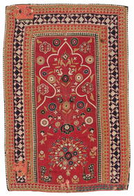
Resht Prayer Niche Embroidery, Persia, Mid 19th C., 3'4'' x 5'2''Material Culture4.6(765)See Sold PriceFeb 29, 2024
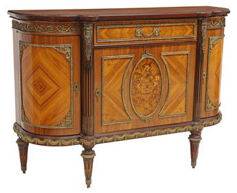
J.P. EHALT FRENCH LOUIS XVI STYLE MARBLE-TOP SERVERAustin Auction Gallery4.7(1.2k)See Sold PriceFeb 25, 2024
ITALIAN CARVED ALABASTER SCULPTURE ON TRAVERTINE PEDESTALAustin Auction Gallery4.7(1.2k)See Sold PriceFeb 25, 2024
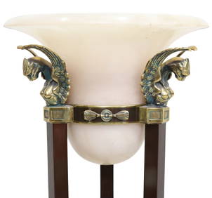
ITALIAN LA RELCO EMPIRE STYLE ALBASTER & GILT METAL TORCHIERE FLOOR LAMPAustin Auction Gallery4.7(1.2k)See Sold PriceFeb 25, 2024
Willem Blaeu, Etc. 17th C. Antiquarian Maps, 2Auctions at Showplace4.5(726)See Sold PriceMar 17, 2024
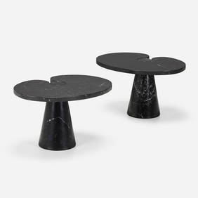
Angelo Mangiarotti, Eros side tables, pairLos Angeles Modern Auctions4.4(24)See Sold PriceFeb 28, 2024