

Popular Searches
Popular Searches

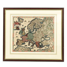
1730 Wetstein Map of Europe During Charlemaigne's Rule
You May Also Like


Similar Sale History


Sold
![3 pieces. Hand-Colored Engraved Maps. [Europe]: H (1 of 0)](https://p1.liveauctioneers.com/dist/images/placeholder.jpg?height=282&quality=70)
Sold

Sold


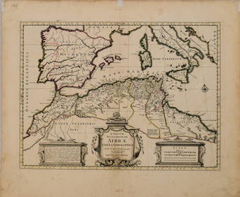
1730 Covens & Mortier Map of North Coast of Africa and Southern Europe -- In Notitiam EcclesiasticamTitle: 1730 Covens & Mortier Map of North Coast of Africa and Southern Europe -- In Notitiam Ecclesiasticam Africae Tabula Geographica Cartographer: Covens & Mortier Year / Place: 1730 c., Amsterdam M


Sold

Sold

Sold

Sold


Sold


Upcoming Sales
View All


![Railways & Transport.- [Prospectus] The Dorking, Brighton, and Arundel Atmospheric Railway, by (1 of 1)](https://p1.liveauctioneers.com/5458/319736/171654703_1_x.jpg?height=282&quality=70&version=1708010439)


TOP