SoldWyld (James) Map of London and Visitor's Guide toWyld (James) Map of London and Visitor's Guide to the Great Exhibition 1851,engraved folding map with original hand-colouring, borders with vignette views of London, uncoloured, 560 x 950mm.,See Sold Price
SoldWyld (James) Wyld's New Plan of LondonWyld (James) Wyld's New Plan of London,originally issued with Visitor's Guide to the Great Exhibition, from Dalston to Camberwell, and Kilburn to Canning Town, decorative border with title inSee Sold Price
SoldWyld (James) Wyld's Guide to the Grand Junction anWyld (James) Wyld's Guide to the Grand Junction and Liverpool and Manchester Railways,folding map, [1838]; The London and Southampton Railway Guide, maps, 1839 § Groombridge (R.) A hand-book fSee Sold Price
SoldWyld (James) A New Map... LondonWyld (James) A New Map of the Country Twenty-Five Miles round London,extending from Beaconsfield to Basildon, and from Harpenden to Dorking, engraved folding map, dissected and linen-backed, wSee Sold Price
SoldPair of Early 19th Century Maps of CanadaPair of maps titled "A Map of the Province of Upper Canada" (1838) and "A Map of the Province of Lower Canada" (1840) by James Wyld, London. Maps measure 23.5" x 37" and exhibit hand-colored highlightSee Sold Price
SoldMap of Mexico and Guatemala, London 1835 Wyld,JamesWyld, James Map of Mexico and Guatemala, London: 1835, showing the positionsof the mines (gold and silver), hand-col..British statue milesInv.200Dimensions: 13" X 31 1/2"See Sold Price
Sold1900 HUGE Folding Color Street Map of London 70001900 HUGE Folding Color Street Map of London 7000 Streets Visitors Travel Guide A large, color indicator map of London from the early 20th-century. This map is bound in a hardcover binding and pairedSee Sold Price
SoldJames Wyld (1812-1887, London), "Map of North AmericaJames Wyld (1812-1887, London), "Map of North America Exhibiting Recent Discoveries Geographical and Nautical," hand colored atlas page, H.- 23 in., W.- 17 in.See Sold Price
SoldWyld (James) Wyld's Map of the Superficial GeologyWyld (James) Wyld's Map of the Superficial Geology of London and its Environs,dissected onto linen, coloured, folding into cloth binder, 530 x 700mm, [c.1890] § Walker (J. & C.) Cumberland, enSee Sold Price
SoldWyld (James) Map of IndiaWyld (James) Map of India, engraved map in original hand-colouring, folding in sections and mounted on linen, in original cloth slip-case, 1843; and 3 other folding maps, London, Europe and thSee Sold Price
SoldLondon.- Wyld (James) A New Map of the CountryLondon.- Wyld (James) A New Map of the Country Twenty-Five Miles Round London, large map in four sections, engraving with hand-colouring, each section approx. 540 x 650 mm. (21 1/4 x 25 1/2 in), eachSee Sold Price
SoldLOT OF 13 BOOK SET, WILLIAM SHAKESPEARE PUBLISHED BYLOT OF 13 BOOK SET, WILLIAM SHAKESPEARE PUBLISHED BY ALTEUS COMPANY, PHILIDELPHIA TOGETHER w/ MOGG'S NEW PICTURE OF LONDON AND VISITOR GUIDE 1844 w/ MAPSSee Sold Price
SoldWyld, James C1850's Map of Turkey & Ottoman Empire"European Dominions of the Ottomans or Turkey in Europe" Lithograph Map Published C1850's by James Wyld, London. Originally Copper Engraved, this a Lithograph Map by the same Publishers. Outline handSee Sold Price
Sold(CANADA.) Wyld, James. A Map of the Province o(CANADA.) Wyld, James. A Map of the Province of Upper Canada. Engraved folding map, 585x885 mm, ample margins; hand-colored in outline; slight offsetting from the cartouche. London, 1838 This map is rSee Sold Price
SoldCombined Maps of London and 25 Miles AroundTitle: Combined Maps of London and 25 Miles Around Publication Date: 1920 ca. Cartographer: GRUBE, H. Publisher: H. GRUBE, LTD. Size: 25.5x35.75 with visitor's guide, index to 7000 streets, theatre plSee Sold Price
SoldWyld, James, publisher Maps & Plans Showing theLondon, [n.d.] Elephant folio, 37 engraved maps and plans, original red half morocco gilt over green cloth, some foxing and occasional light dampstaining; Belmas, J. Journaux des Siéges faits ouSee Sold Price
Wyld: Map of Central America, 1856WYLD, James. Wyld's Map of Central America, Nicaragua, Honduras, Costa Rica, Mosquita, The British Colonies with the Boundaries & Treaty Lines of the Central American States. London : James Wyld, GeogSee Sold Price
SoldWyld (James) Environs of LondonWyld (James) Environs of Londoncircular map of 25 miles radius around London, showing the latest railway extensions, from Welwyn to Reigate, and from Windsor to East Tilbury, engraved map withSee Sold Price
Sold1861 CIVIL WAR MILITARY MAP BY JAMES WYLD1861 CIVIL WAR MILITARY MAP BY JAMES WYLD Folds up into a book. By James Wyld, the geographer to the Queen, whose office was in London. Map measures 35" tall (88.9cm) x 24" wide (60.96cm). Depicting NSee Sold Price
SoldWyld, James C1840 Group of 4 Hand Coloured MapsIncl Spain/Portugal, Syria, Asia and Turkey in Asia. Hand Coloured Steel Engraved Map Published C1840, London for "Atlas of Modern Geography" by James Wyld. Centre fold as published. Paper Size: 11 xSee Sold Price
SoldJames Wyld, 'Environs of London', a mid C19th foldingJames Wyld, 'Environs of London', a mid C19th folding map of London, in original case, Best BidSee Sold Price
SoldJames Wyld, 'Environs of London', a mid C19th foldingJames Wyld, 'Environs of London', a mid C19th folding map of London, in original case, Best BidSee Sold Price
SoldJames Wyld MAP OF THE PROVINCE OF CANADA AND PARTOF THE UNITED STATES; WITH THE RAILWAYS, ROADS AND CANALS BY JAMES WYLD, GEOGRAPHER TO THE QUEEN AND H.R.H. PRINCE ALBERT. CHARING CROSS, EAST, LONDON, Four Doors from Trafalgar Square. c. 1850. LinenSee Sold Price
[MAPS] James Wyld: Map of Australia: Compiled from the Nautical Surveys,James Wyld Map of Australia: Compiled from the Nautical Surveys, made by order of The Admiralty and other authentic documents / by James Wyld, Geographer to the Queen. London: James Wyld, No date.56cmSee Sold Price
HONEST JOHN OLIVER by James Morton 1st Edition Inscribed by Author ScarceLuis Porretta Fine Arts4.3(10)See Sold PriceMar 02, 2024
THOMAS MOULE 1837 Colored Map of Warwickshire Framed vgcLuis Porretta Fine Arts4.3(10)See Sold PriceMar 02, 2024
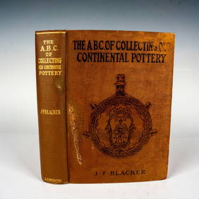
Collecting Old Continental Pottery Book, by J. F. BlackerLion and Unicorn4.8(1.9k)See Sold PriceFeb 25, 2024
Schomburgk - The Comuti or Taquiare (Taquiari) Rock on the River EssequiboTrillium Antique Prints & Rare Books4.5(32)See Sold PriceFeb 24, 2024
Schomburgk - Pirara and Lake Amucu, The Site of El DoradoTrillium Antique Prints & Rare Books4.5(32)See Sold PriceFeb 24, 2024
Kent & Sussex.- Moss (W.G.) The History and Antiquities of the Town and Port of Hastings, 1824; andForum Auctions4.3(53)See Sold PriceFeb 29, 2024
American White Pelican plate from Audubon's Royal OctavoPBA Galleries4.7(385)See Sold PriceMar 07, 2024
THE WHOLE CHRONICLE OF POLYBIUS ANCIENT IN ENGLISH, 1756NY Elizabeth 4.2(86)See Sold PriceMar 03, 2024
James Sowerby (1757 - 1822) - Set of 8 Botanical Prints - Heath Cudweed - Saxifraga Nivalis -Proverde Auctions4.3(3)See Sold PriceFeb 28, 2024
James Sowerby (1757 - 1822) - Set of 8 Botanical Prints - Birthwort, Aristolochia clematitis -Proverde Auctions4.3(3)See Sold PriceFeb 28, 2024
James Sowerby (1757 - 1822) - Set of 10 Botanical Prints -Proverde Auctions4.3(3)See Sold PriceFeb 28, 2024
James Sowerby (1757 - 1822) - Set of 10 Botanical Prints - Common Sea-Buckthorn - Orobanche RapumProverde Auctions4.3(3)See Sold PriceFeb 28, 2024
James Sowerby (1757 - 1822) - Set of 10 Botanical Prints - Orobanche Common Lesser - CentrolepisProverde Auctions4.3(3)See Sold PriceFeb 28, 2024
James Sowerby (1757 - 1822) - Set of 10 Botanical Prints - Potentilla anserina - Poa aquatica -Proverde Auctions4.3(3)See Sold PriceFeb 28, 2024
Antique Map - Views on the coast of Asia. J. Webber del. Engraved after J. Webber and W. Bligh.Proverde Auctions4.3(3)See Sold PriceFeb 28, 2024


![[MAPS] James Wyld: Map of Australia: Compiled from the Nautical Surveys, (1 of 6)](https://p1.liveauctioneers.com/8597/288240/152537441_1_x.jpg?height=282&quality=70&version=1683682013)