ATLAS of ANTIENT GEOGRAPHY by SAMUEL BUTLER 1843John McInnis Auctioneers,LLC4.5(505)See Sold PriceFeb 24, 2024
18TH C. ANTIQUE MAP: FRENCH & INDIAN WAR, FRAMEDThomaston Place Auction Galleries4.4(393)See Sold PriceFeb 24, 2024
Rand McNally Railroad Map Cabinet w/ 21 Railroad MapsRail & Road Auctions4.6(165)See Sold PriceMar 08, 2024
Keith Haring - Ink on New York Map, Best Buddies, Inscribed, Signed, and DatedSapphire Auction Gallery4(67)See Sold PriceMar 02, 2024
LATE 17TH C. FRENCH MAP OF THE NEW WORLD BY ALEXIS-HUBERT JAILLOT (1632-1712)Thomaston Place Auction Galleries4.4(393)See Sold PriceFeb 24, 2024
Central Railroad of New Jersey Map of Sandy Hook Route-ca. 1903JM Hobby Supply and Railroad Artifact Auctions4.4(127)See Sold PriceFeb 24, 2024
Lot of Six Mixed Atlas Box Cars-HO Scale-New in BoxJM Hobby Supply and Railroad Artifact Auctions4.4(127)See Sold PriceFeb 25, 2024
Rand McNally/Santa Fe Railroad Map of Iowa-1912JM Hobby Supply and Railroad Artifact Auctions4.4(127)See Sold PriceFeb 24, 2024
NICOLAES VISSCHER (NETHERLANDS, 1618-1709) MAP OF THE NEW WORLDThomaston Place Auction Galleries4.4(393)See Sold PriceFeb 24, 2024
17TH C. WORLD MAP BY NICOLAES VISSCHER (NETHERLANDS, 1618-1709)Thomaston Place Auction Galleries4.4(393)See Sold PriceFeb 24, 2024
Lot of Six Mixed Atlas Cabooses-HO Scale-New in BoxJM Hobby Supply and Railroad Artifact Auctions4.4(127)See Sold PriceFeb 25, 2024
SoldWyld, James C1840 Group of 4 Hand Coloured MapsIncl Spain/Portugal, Syria, Asia and Turkey in Asia. Hand Coloured Steel Engraved Map Published C1840, London for "Atlas of Modern Geography" by James Wyld. Centre fold as published. Paper Size: 11 xSee Sold Price
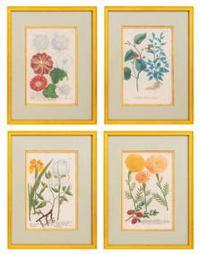
James Andrews a group of 12 botanical platesJames Andrews a group of 12 botanical plates,including pansies, petunias, a rose, and others, hand-coloured lithographs, c.1840. 200 x 130mm (7 3/4 x 5 1/4 in), uniformly framed and glazed (12See Sold Price
SoldWyld (James)Wyld (James) Scotland with its Isles,hand-coloured engraved map, in sections, linen-backed, 800 x 570mm., original cloth slip-case, engraved label, 1836.See Sold Price
[WYLD, James] A lot of 12 maps and a title page[WYLD, James] A lot of 13 pieces, 12 of which are engraved and most hand coloured maps. Sold as a collection. James Wyld, the Younger (1812-1887) was a Geographer to the Queen and H.R.H PrinceAlbert.See Sold Price
SoldWyld (James) Railway Map of England, Wales andWyld (James) Railway Map of England, Wales and Scotland..., ?second issue, large folding hand-coloured engraved map in 2 parts, overall c.2060 x 1240 mm., dissected and mounted on linen with cloth endSee Sold Price
Soldfolding hand-coloured lithograph map, linen-backeWyld (James, publisher) Chart of the Arctic Regions from the Admiralty Surveys, folding hand-coloured lithograph map, linen-backed, folding into original cloth covers with printed paper labelSee Sold Price
SoldAtlases.- Wyld (James) A General Atlas..., Edinburgh,Atlases.- Wyld (James) A General Atlas..., first edition, engraved vignette title, 2 tables of comparative heights of mountains and lengths of rivers, and 41 maps hand-coloured in outline by N.R.HewitSee Sold Price
SoldWyld (James Classical Atlas 1836Wyld (James) A New and Elegant Classical Atlas,engraved double-page title with vignette and 17 double-page maps, hand-coloured in outline, lightly browned, some staining, spotting and finger-sSee Sold Price
SoldWyld (James) A General Atlas 1825Wyld (James) A General Atlas,engraved title with vignette, 44 maps, hand-coloured in outline by N.R. Hewitt after Wyld, 2 tables (hand-coloured in outline) and hand-coloured illustrations, offSee Sold Price
SoldWyld (James, publisher) Chart New ZealandWyld (James, publisher) This Chart of New Zealand,from original surveys, folding engraved map hand-coloured in outline, slip-case with printed label, n.d. [c.1842] § Stanford (Edward, publisheSee Sold Price
SoldJames Wyld, British 1812-1877- ''West India & BahamaJames Wyld, British 1812-1877- ''West India & Bahama Islands'', publ. 5 Charing Cross, Jan 1st 1825; hand coloured engraved map, 55.5x79.5cmSee Sold Price
SoldWyld (James) British Isles.Wyld (James) Map of the Superficial Geology of the British Isles...the Line of Railways...and the Steam Packet Routes,large folding map, hand-coloured in outline, dissected and linen-backed, sSee Sold Price
SoldWyld (James) Post Map of Europe...with the Post DiWyld (James) Post Map of Europe...with the Post Distances, Roads, Railways...,engraved map, hand-coloured in outline, 865 x 1168mm, disected and linen-backed, occasional spotting, a few stainsSee Sold Price
SoldFOUR VARIIOUS MAPSRobert Morden Buckinghamshire, engraved map coloured in outline, 42 x 34cm; William Kip, Essex Comitatus, hand coloured engraved map, 29 x 37cm; James Wyld. The Country Round Washington from 'StrategiSee Sold Price
SoldPlesch‚‚f (Sergey) SurveyPlesch‚‚f (Sergey) Survey of the Russian Empire,translated by James Smirnove, third edition, folding engraved map (hand-coloured in outline) and 4 folding hand-coloured plates, map and platesSee Sold Price
Wyld, Map..Superficial Geology..British IslesWyld (James) Map of the Superficial Geology of the British Isles...the Line of Railways...and the Steam Packet Routes,large folding map, hand-coloured in outline, dissected and linen-backed, sSee Sold Price
SoldHeger, Map of the Post Roads of GermanyHeger (F.J.) A Map of the Post Roads of Germany,folding engraved map hand-coloured, 780 x 950 mm., worn slip-case with title label, Faden, 1795 § Wyld (James) The Germanic Confederated States,See Sold Price
England & WalesEngland & Wales.- Wyld (James) A New Map of England and Wales, Projected upon the Trigonometrical Operations made for the General Survey of the Kingdom, steel engraved folding map, hand coloured, dissSee Sold Price
Wyld (James) A General Atlas...Wyld (James) A General Atlas...,engraved title with vignette, 44 engraved maps partly hand-coloured, some double-page, 2 engraved tables, 7 vignette illustrations, all but 1 hand-coloured, 2 dSee Sold Price
Bowen (Emanuel) - A Group of English Road Maps,including Stratford to Chester, Bristol to Cirencester, Chester to Holyhead, 13 small engraved road maps, 4 hand-coloured, 1 double sided, each ranging from c.190 x 180 mm to 252 x 323 mm, vertical ceSee Sold Price
SoldSeller (John) - A Group of English County Mapsincluding Staffordshire, Pembrokeshire, Breckonshire and others , 8 engraved maps, 4 hand-coloured, most with text below, c.170 x 270mm , 1787 (8)See Sold Price
Sold19th Century handcoloured gilt framed map on linen, '19th Century handcoloured gilt framed map on linen, ' The Environs of London ' by James WyldSee Sold Price
SoldCole & Roper - A Group of English County Mapsincluding Wiltshire, Oxforshire, Northumberland and other , 11 engraved hand-coloured maps, including 4 duplicates, sheet edges frayed from binding, contemporary ink numbering on top right corner, c.2See Sold Price
SoldJardine, William C1840 Group of 5 HC Cattle PrintsHand Coloured Steel Engraving/Etchings Published 1833-43 by W.H.Lizars, Edinburgh for "The Naturalist's Library" by Sir William Jardine. Fine hand colour as issued. Paper Size: 6.5 x 4.25 inch (17 x 1See Sold Price
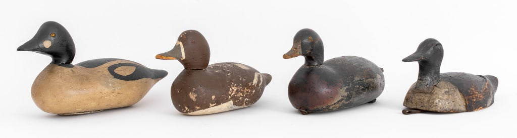
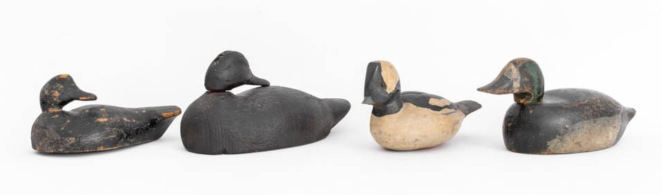
Signed American Hand-Carved Wood Duck Decoys, 4Auctions at Showplace4.6(740)See Sold PriceMar 03, 2024
Map: An 18thC engraved and hand coloured map of Buckinghamshire after Robert Morden. Approx. 8 1/4"Claydon Auctioneers Ltd4.3(125)See Sold PriceFeb 26, 2024
Map: A 19thC engraved and hand coloured map of South America. Published by the Society for theClaydon Auctioneers Ltd4.3(125)See Sold PriceFeb 26, 2024
Map: A 19thC engraved and hand coloured map of St. Petersburg / Sanktpeterburga by W. B. Clarke.Claydon Auctioneers Ltd4.3(125)See Sold PriceFeb 26, 2024
Map: An engraved and hand coloured map titled The Countie of Nottingham described The Shire TownesClaydon Auctioneers Ltd4.3(125)See Sold PriceFeb 26, 2024
Map: A 17thC engraved and hand coloured map of Bedfordshire after Robert Morden. Approx. 12 1/2" xClaydon Auctioneers Ltd4.3(125)See Sold PriceFeb 26, 2024
Map: An 18thC engraved and hand coloured map of North America and South America, titled DeClaydon Auctioneers Ltd4.3(125)See Sold PriceFeb 26, 2024
Map: A 19thC engraved and hand coloured map of Buckingham titled A New Map of BuckinghamshireClaydon Auctioneers Ltd4.3(125)See Sold PriceFeb 26, 2024
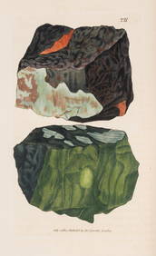
Mineralogy.- Sowerby (James) British Mineralogy, 3 vol. only (of 5), 1804-09; and 4 others, naturalForum Auctions4.3(53)See Sold PriceFeb 29, 2024
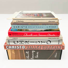
Christo Hand-Signed Exhibition Catalogues and Monographs, Group of 12Capsule Auctions4.6(168)See Sold PriceFeb 28, 2024
Large Japanese Bronze Figural Group, Daimyo and Sons, Meiji PeriodNeue Auctions4.6(357)See Sold PriceMar 02, 2024
Great Blue Heron, Audubon Royal Octavo hand-colored lithographPBA Galleries4.7(385)See Sold PriceMar 07, 2024
Roseate Spoonbill, Audubon, Royal Octavo hand-colored lithographPBA Galleries4.7(385)See Sold PriceMar 07, 2024
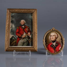
ANTIQUE PORTRAIT MINIATURES OF LORD HEATHFIELDPridham's Auctions & Appraisals4.7(223)See Sold PriceMar 02, 2024
James Sowerby (1757 - 1822) - Set of 8 Botanical Prints - Heath Cudweed - Saxifraga Nivalis -Proverde Auctions4.3(3)See Sold PriceFeb 28, 2024
James Sowerby (1757 - 1822) - Set of 8 Botanical Prints - Birthwort, Aristolochia clematitis -Proverde Auctions4.3(3)See Sold PriceFeb 28, 2024
James Sowerby (1757 - 1822) - Set of 10 Botanical Prints -Proverde Auctions4.3(3)See Sold PriceFeb 28, 2024
James Sowerby (1757 - 1822) - Set of 10 Botanical Prints - Common Sea-Buckthorn - Orobanche RapumProverde Auctions4.3(3)See Sold PriceFeb 28, 2024
James Sowerby (1757 - 1822) - Set of 10 Botanical Prints - Orobanche Common Lesser - CentrolepisProverde Auctions4.3(3)See Sold PriceFeb 28, 2024
James Sowerby (1757 - 1822) - Set of 10 Botanical Prints - Potentilla anserina - Poa aquatica -Proverde Auctions4.3(3)See Sold PriceFeb 28, 2024


![[WYLD, James] A lot of 12 maps and a title page (1 of 1)](https://p1.liveauctioneers.com/1124/187577/94368903_1_x.jpg?height=282&quality=70&version=1607095126)