MAP - PIETER SCHENK / VALK / JANSSEN Hand Colored superb Map Central Italy c1702Luis Porretta Fine Arts4.3(10)See Sold PriceMar 02, 2024
CHARLES ROLLIN c1828 Ceasar Hand Colored Africa Military MapLuis Porretta Fine Arts4.3(10)See Sold PriceMar 02, 2024
MAP - Dufour, A. H. ( Malte / Brun ) :MAP - ESPAGNE PARTIE SUD DIVISEE EN PROVINCES ANCIENNES ( MAPLuis Porretta Fine Arts4.3(10)See Sold PriceMar 02, 2024
RIGOBERT BONNE c1787 Original Colored Map Germany & Region 15" x 12"Luis Porretta Fine Arts4.3(10)See Sold PriceMar 02, 2024
AMBROISE TARDIEU c1822 Napoleonic War Map GermanyLuis Porretta Fine Arts4.3(10)See Sold PriceMar 02, 2024
MAP - AMBROISE TARDIEU c1822 Napoleonic Miltary Map GermanyLuis Porretta Fine Arts4.3(10)See Sold PriceMar 02, 2024
1822 Rare Map by Ambroise Tardieu Napoleon Caldiero Battle of Vento 17" x 11Luis Porretta Fine Arts4.3(10)See Sold PriceMar 02, 2024
PIETER SCHENK / VALK / JANSSEN Hand Colored Map of Rhodes Greece ca1702 vgcLuis Porretta Fine Arts4.3(10)See Sold PriceMar 02, 2024
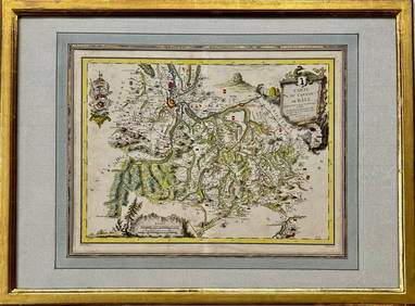
Map: Carte du Canton de Bale, Jacques Clermont, Paris, 1788Kensington Estate Auction4.6(219)See Sold PriceFeb 26, 2024
SoldWorld Map in Hemispheres 19th CMap: Mapemonde. (World map in hemispheres) Maker: Unknown Origin: French, 19th Century Medium: Original lithograph with hand coloring. Sheet Size: 6 1/4 x 9 inches No Reserve: This lot starts at $1 anSee Sold Price
SoldWilliam Darton, (10) antique mapsWilliam Darton, (10) antique maps, William Darton (British, 19th c.), "The Western Hemisphere or New World", "South America", etc., 12.75"h x 10.5"w (sheet), unframed Provenance: Property from a majorSee Sold Price
SoldEarly 19th c. World Map Mercator's ProjectionEarly 19th c. World Map Mercator's Projection that measure 10x13. Some edge damage at right bottom otherwise in very good condition for it's age, c.1814. Suggested bid $250See Sold Price
SoldLg Framed early 19th c. Map of the WorldLg Framed early 19th c. Map of the World, "Mappe Monde", Indication des trois voyages du Capitaine Cook, French 1816 in floral gilt 32" x 46" frame Condition; was folded, some wear along fold lines frSee Sold Price
SoldFolk Art Double-Hemisphere World Map Folk Art Double-Hemisphere World Map American, 19th century. Ink and watercolor on paper. A folk art double-hemisphere world map, featuring hand-drawn and labeled continents, oceans, and countries,See Sold Price
SoldGrp: 54 Maps of the World 18th and 19th c.Group of 54 maps of various regions of the world, dating from the 18th and 19th century. Foldable Map of Navarre on paper attached to linen, Tomás López de Vargas Machuca (1730-1802) "Map of theSee Sold Price
Sold19thc Pair of Colton World Atlas MapsPair of 19th century map pages from J.H. Colton's Atlas Of The World. Page No. V. ( top half ) Map Of The World, Illustrating the principal features of The Land And The Co-Tidal Lines, ( bottom half )See Sold Price
Sold19TH C. SCHOOL GIRL MAP - "A Map of the World" by19TH C. SCHOOL GIRL MAP - "A Map of the World" by Hannah Comstock, Danbury (Connecticut), Sept 1815, ink and gouache on paper, the map based on Hondius's "Nova Totius Terraum Orbis" as first publishedSee Sold Price
Double Hemisphere World Map, 1799Map: "Map of the World, Shewing the Tracks & Discoveries of Capt. Cook. Drawn from The Best Authorities..." Size: Double Quarto – 13.60 W Inches Publisher: C. Dilly and G.g. & J. Robinson 1799-09-01See Sold Price
SoldSTOOPENDAAL, DANIEL. Werelt Caert. [Amsterdam, c. 1680](MAP) STOOPENDAAL, DANIEL Werelt Caert. (Amsterdam, c. 1680). Double-page engraved hand-colored double-hemisphere world map depicting California as an island. With corner vignettes depicting allegoricSee Sold Price
SoldMappe-Monde en Deux Hemispheres, Poirson/Fremin, 1821"Mappe-Monde en Deux Hemispheres" drawn by Jean Baptiste Poirson (1761-1831), published by A. R. Fremin (fl. c. 1810-c. 1860), 1821. Copper plate engraving depicting a double hemisphere world map, focSee Sold Price
SoldMappemonde en Deux Hemispheres Conrad Malte-Brun 1846Antique Map 'Mappemonde en Deux Hemispheres' [World Map in Two Hemispheres] by Conrad Malte-Brun (1775 - 1826) | DATE: c. 1846 | SIZE: Map with borders: Approx. 16" H x 22" W (40.64 x 55.88cm); imageSee Sold Price
SoldLate 19th / Early 20th C Advertising CardsLot includes a selection from Singer sewing machine, Gold Medal Flour, World's Fair Map 1934, place cards, and related items.See Sold Price
Sold[Trains, Travel, 19th c.] Pair, Map & ProgramIncludes: *** DENVER AND RIO GRANDE RAILWAY, SCENIC LINE OF THE WORLD. NY, 1885. 28" x 15". Creased as folded, one 5" tear along one fold, some other smaller splits at folds/corners. Contains map andSee Sold Price
Sold19TH C. RE-STRIKE OF 17TH C. HONDIUS MAP OF THE WORLD"Nova Totius Terrarum Orbis Geographica ac Hydrographica Tabula, auct. Ind. Hondio.", a Paris, Chez Nicolas Bercy, 1649. Hand colored engraving, in stick frame, no glass. OS: 20 1/2" x 26 3/4", imageSee Sold Price
Sold19th C. Belgian Oil Genre Scene, "The Governess"Belgian School, 19th century. "The Governess", oil on canvas, unsigned. Genre painting depicting three women sitting in a decorated library among books and maps of the world, the governess sitting inSee Sold Price
SoldFramed Hand Colored Map of The World 19th CenturyFramed Hand Colored Map of The World 19th Century. Original Map of World Hemispheres with supposed population and religious division. Certificate of Authenticity on back.Condition: Very Good, slight wSee Sold Price
SoldWorld map with California an islandHeading: (World) Author: Anonymous Title: Mappamondo Place Published: [No place] Publisher: Date Published: [c.1700?] Description: Copper-engraved double-hemisphere map of tSee Sold Price
SoldDouble Hemisphere Map of the World by VisscherMapsLovely Double Hemisphere Map of the World by Visscher c. 1680, ORBIS TERRARUM NOVA ET ACCURATISSIMA TABULA, By Nicolas Visscher, Amsterdam, Choice Fine. 18.25” x 22”, copper-engraved iSee Sold Price
Sold19th C Hand Colored Map of State of Maine FRAMEDPublished by S.Augustus Mitchell, Jr. having a published date year of 1860. This hand colored map contains maps of the various countries of the world and plans of cities. Inset at lower right featuresSee Sold Price
SoldTWO 19TH C BOUND BOOKS TO INCLUDE NARRATIVE OFVOYAGES AND TRAVELS IN THE NORTHERN AND SOUTHERN HEMISPHERES, COMPRISING THREE VOYAGES ROUND THE WORLD, TOGETHER WITH A VOYAGE OF SURVEY AND DISCOVERY IN THE PACIFIC OCEAN AND ORIENTAL ISLANDS BY AMASSee Sold Price
SoldLaunay World Map - Typus Orbis Terrarum, 1720Map: Launay World Map - Typus Orbis Terrarum Cartographer: C. Launay Date: ca. 1720 Size: 5 x 8 inches A quite rare, unique and charming double hemisphere map showing very rough approximations for theSee Sold Price
SoldTwo 19th C. Books on World Travel and HistoryIncludes Travels and Adventures of the Most Celebrated Travelers in all Parts of the World by Henry Howe dated 1860 and The Earth Girdled by T. DeWitt Talmadge dated 1896. See photos for condition andSee Sold Price
SoldExtremely Rare and Nearly Complete 19th C. Stamp AlbumExtremely rare 19th century stamp collection books; Nearly complete and extremely rare 19th century stamp album; contains over 1000 world stamps categorized by country, including the United States, GrSee Sold Price
17TH C. WORLD MAP BY NICOLAES VISSCHER (NETHERLANDS, 1618-1709)Thomaston Place Auction Galleries4.4(393)See Sold PriceFeb 24, 2024
LATE 17TH C. FRENCH MAP OF THE NEW WORLD BY ALEXIS-HUBERT JAILLOT (1632-1712)Thomaston Place Auction Galleries4.4(393)See Sold PriceFeb 24, 2024
19thc Colton Map, Comparitive Size of Lakes & IslandsConnoisseur Auctions3.9(336)See Sold PriceFeb 24, 2024
Map: A 19thC engraved and hand coloured map of South America. Published by the Society for theClaydon Auctioneers Ltd4.3(125)See Sold PriceFeb 26, 2024
Map: A 19thC engraved and hand coloured map of St. Petersburg / Sanktpeterburga by W. B. Clarke.Claydon Auctioneers Ltd4.3(125)See Sold PriceFeb 26, 2024
Map: A 19thC engraved map titled Gloucestershire from the Best Authorities, after John Cary. Approx.Claydon Auctioneers Ltd4.3(125)See Sold PriceFeb 26, 2024
Map: A 19thC engraved and hand coloured map of Buckingham titled A New Map of BuckinghamshireClaydon Auctioneers Ltd4.3(125)See Sold PriceFeb 26, 2024
Map: A 19thC engraved map of West Riding, titled A Map of the North Part of the West Riding ofClaydon Auctioneers Ltd4.3(125)See Sold PriceFeb 26, 2024
1816 MAP SOUTHERN PART OF RUSSIA or MUSCOVY in EUROPE copper engraving ANTIQUEJasper524.5(9.9k)See Sold PriceFeb 27, 2024
1816 MAP NORTHERN PART OF RUSSIA or MUSCOVY in EUROPE copper engraving ANTIQUEJasper524.5(9.9k)See Sold PriceFeb 27, 2024
1849 Hand Colored Blair Map of World in HemispheresMatthew Bullock Auctioneers4.7(1.8k)See Sold PriceMar 02, 2024
Rare 19thc Colton Map, Argentine Republic, Chile, Uruguay, PataguayConnoisseur Auctions3.9(336)See Sold PriceMar 16, 2024
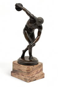
Continental World Tour Bronze Sculpture, Ca. Late 19th C., "Discobolus", H 15.25" W 5" L 9"DuMouchelles4.6(830)See Sold PriceMar 15, 2024


![STOOPENDAAL, DANIEL. Werelt Caert. [Amsterdam, c. 1680] (1 of 1)](https://p1.liveauctioneers.com/197/58374/28679608_1_x.jpg?height=282&quality=70&version=1405541743)


![[Trains, Travel, 19th c.] Pair, Map & Program (1 of 5)](https://p1.liveauctioneers.com/3532/117365/60345272_1_x.jpg?height=282&quality=70&version=1519867546)