ATLAS of ANTIENT GEOGRAPHY by SAMUEL BUTLER 1843John McInnis Auctioneers,LLC4.5(505)See Sold PriceFeb 25, 2024
18TH C. ANTIQUE MAP: FRENCH & INDIAN WAR, FRAMEDThomaston Place Auction Galleries4.4(393)See Sold PriceFeb 24, 2024
Rand McNally Railroad Map Cabinet w/ 21 Railroad MapsRail & Road Auctions4.6(165)See Sold PriceMar 08, 2024
Keith Haring - Ink on New York Map, Best Buddies, Inscribed, Signed, and DatedSapphire Auction Gallery4(67)See Sold PriceMar 02, 2024
LATE 17TH C. FRENCH MAP OF THE NEW WORLD BY ALEXIS-HUBERT JAILLOT (1632-1712)Thomaston Place Auction Galleries4.4(393)See Sold PriceFeb 24, 2024
Central Railroad of New Jersey Map of Sandy Hook Route-ca. 1903JM Hobby Supply and Railroad Artifact Auctions4.4(127)See Sold PriceFeb 24, 2024
Lot of Six Mixed Atlas Box Cars-HO Scale-New in BoxJM Hobby Supply and Railroad Artifact Auctions4.4(127)See Sold PriceFeb 25, 2024
Rand McNally/Santa Fe Railroad Map of Iowa-1912JM Hobby Supply and Railroad Artifact Auctions4.4(127)See Sold PriceFeb 24, 2024
NICOLAES VISSCHER (NETHERLANDS, 1618-1709) MAP OF THE NEW WORLDThomaston Place Auction Galleries4.4(393)See Sold PriceFeb 24, 2024
17TH C. WORLD MAP BY NICOLAES VISSCHER (NETHERLANDS, 1618-1709)Thomaston Place Auction Galleries4.4(393)See Sold PriceFeb 24, 2024
Lot of Six Mixed Atlas Cabooses-HO Scale-New in BoxJM Hobby Supply and Railroad Artifact Auctions4.4(127)See Sold PriceFeb 25, 2024
World chart of isothermal lines. Mean annual temperature. GEORGE AIKMAN 1856 mapCAPTION PRINTED BELOW PICTURE: 'Chart of isothermal lines, shewing the mean annual temperature of the different parts of the Earth's surface' DATE PRINTED: 1856 IMAGE SIZE: Approx 30.0 x 41.5cm, 11.75See Sold Price
World chart of isothermal lines. Mean annual temperature. GEORGE AIKMAN 1862 mapCAPTION PRINTED BELOW PICTURE: 'Chart of isothermal lines, shewing the mean annual temperature of the different parts of the Earth's surface' DATE PRINTED: 1862 IMAGE SIZE: Approx 30.0 x 42.0cm, 11.75See Sold Price
Chart of Isothermal Lines,Title/Content of Map: Chart of Isothermal Lines, Date: 1847 Cartographer: AIKMAN, GEO. Size: 10.5Height - 15.25Width Publisher: Adam & Charles Black shewing the mean annual temperature of the differenSee Sold Price
Temperature Chart of the world. 1846 by A and C BlackTitle: Temperature Chart of the world. 1846 by A and C Black Date/Period: 1846 Materials: Copperplate engraved Size: 12 x 17" Temperature chart of the world. Isothermal lines shows the mean temperaturSee Sold Price
A chart of magnetic curves of equal variation. World. GEORGE AIKMAN 1856 mapCAPTION PRINTED BELOW PICTURE: 'A chart of magnetic curves of equal variation' DATE PRINTED: 1856 IMAGE SIZE: Approx 28.0 x 42.5cm, 11 x 16.75 inches (Large) TYPE: Antique atlas map CONDITION: Good; sSee Sold Price
WORLD CLIMATE. July temperature. Summer/winter Europe. JOHNSTON 1906 old mapTITLE/CONTENT OF MAP: 'Climatological Chart, Showing by Lines & Figures the mean Temperature for July; Inset maps of Enlarged map showing the Summer, Winter & Mean temperatures of places in the BritisSee Sold Price
WORLD CLIMATE. January temperature. Summer/winter Europe. JOHNSTON 1901 mapTITLE/CONTENT OF MAP: 'Climatological Chart, Showing by Lines & Figures the mean Temperature for January; Inset maps of Enlarged map showing the Summer, Winter & Mean temperatures of places in the BriSee Sold Price
Rivers and mountains. Physical geography. World. GEORGE AIKMAN 1856 old mapCAPTION PRINTED BELOW PICTURE: 'Physical geography' DATE PRINTED: 1856 IMAGE SIZE: Approx 28.5 x 39.5cm, 11.25 x 15.5 inches (Large) TYPE: Antique atlas map with original hand colouring / coloring CONSee Sold Price
The World, on Mercator's projection by GEORGE AIKMAN. Asia-centric 1856 mapCAPTION PRINTED BELOW PICTURE: 'The World, on Mercator's projection' DATE PRINTED: 1856 IMAGE SIZE: Approx 28.0 x 43.0cm, 11 x 16.75 inches (Large) TYPE: Antique atlas map with original hand colouringSee Sold Price
Bartholomew: Antique World Climate Map, 1901TITLE/CONTENT OF MAP: 'The World-Climate; Mean Annual Rainfall; Mean Annual Temperature; Prevailing Winds; Annual Distribution Cloudiness' DATE PRINTED: 1901 IMAGE SIZE: Approx 32.0 x 44.5cm, 12.5 x 1See Sold Price
WORLD CLIMATE. Rainfall Temperature Winds Cloudiness. BARTHOLOMEW 1912 old mapTITLE/CONTENT OF MAP: 'The World - Climate; Mean Annual Rainfall with limits of Snowfall; Mean Annual Temperature; Prevailing Winds for the year; Annual distribution of Cloudiness' DATE PRINTED: 1912See Sold Price
The World, on Mercator's projection by GEORGE AIKMAN.TITLE/CONTENT OF MAP: 'The World, on Mercator's projection' Date: 1856 IMAGE SIZE: Approx 28.0 x 43.0cm, 11 x 16.75 inches (Large) TYPE: Antique atlas map with original hand colouring / coloring CONDISee Sold Price
The World, on Mercator's projection by GEORGE AIKMAN.TITLE/CONTENT OF MAP: 'The World, on Mercator's projection' Date: 1856 IMAGE SIZE: Approx 28.0 x 43.0cm, 11 x 16.75 inches (Large) TYPE: Antique atlas map with original hand colouring / coloring CONDISee Sold Price
Aikman: Antique Map of World, Magnetic Curves, 1856TITLE/CONTENT OF MAP: 'A chart of magnetic curves of equal variation' DATE PRINTED: 1856 IMAGE SIZE: Approx 28.0 x 42.5cm, 11 x 16.75 inches (Large) TYPE: Antique atlas map CONDITION: Good; suitable fSee Sold Price
Anson (George) & Seale (Richard William) A Chart of theAnson (George) & Seale (Richard William) A Chart of the Southern Part of South America…, copper engraved map, hand coloured, from Anson’s ‘A Voyage Round the World’, fold lines, two holes alonSee Sold Price
SoldColton's Atlas of the World Vol. II, 1856Title: Colton's Atlas of the World, Illustrating Physical and Political Geography... Author: Colton, George W. Description: Vol. II only. With 40 (of 42) hand-colored maps and charts (3 are double-pagSee Sold Price
Sold1748 George Anson World Voyage 3 HUGE MAPS Spain South America Sea Navigation1748 George Anson World Voyage 3 HUGE MAPS Spain South America Sea Navigation George Anson was an 18th-century British Navy admiral who is noted for his important world voyage in which he circumnavigaSee Sold Price
SoldHUNDREDS Nautical, Geology & World Geography MapsAn historical estate collection consisting of hundreds of individual maps and charts, produced by and for various sources. Includes original U.S. Geological Survey maps, National Geographic Society woSee Sold Price
Sold1761 George Anson Voyage Round the World MAPS Spain1761 George Anson Voyage Round the World MAPS Spain South America Brazil Peru George Anson was an 18th-century British Navy admiral who is noted for his important world voyage in which he circumnavigaSee Sold Price
SoldFramed Map Showing World Time And CurrencyUnique rendering of the world map showing variation in world time when 12 noon at Greenwich. Greenwhich time has Clock face in relief, Foreign money corresponding roughly with a shilling lines the perSee Sold Price
Sold1746 Homann World MapTitle: 1746 Homann World Map -- Planiglobii Terrestris Mappa Universalis utrumque Hemisphaerium Orient et Occidentale Repraesentans ex IV. Mappis Generalibus ... / Mappe-Monde qui Represente les DeuxSee Sold Price
SoldSeutter World Map, 1730Title: 1730 Seutter World Map Cartographer: M. Seutter Published: 1730 c Augsburg Measurements: 19.5 x 22.7 in. Diversi Globi Terr-Aquei Statione Variante et Visu Intercedente per Coluros Tropicorum pSee Sold Price
Elwe: Antique World Map, 1792Map: 1792 Elwe World Map -- Mappe Monde ou Description du Globe Terrestre & Aquatique Cartographer: J. Elwe Year / Place: 1792 Amsterdam Dimensions: 18 x 24 in. Condition: Very Good. Expertly repairedSee Sold Price
Elwe: World Map, 1792Map: 1792 Elwe World Map -- Mappe Monde ou Description du Globe Terrestre & Aquatique Cartographer:J. Elwe after A. Jaillot Date/Place: 1792 Amsterdam Map Dimensions:18 x 24 in Double page engraved haSee Sold Price
Michigan Southern and Northern Indiana RR 14th Annual Report-February 28, 1869JM Hobby Supply and Railroad Artifact Auctions4.4(127)See Sold PriceFeb 24, 2024
Rand McNally/Santa Fe Railroad Map of Iowa-1912JM Hobby Supply and Railroad Artifact Auctions4.4(127)See Sold PriceFeb 24, 2024
Union Pacific RR Across The Continent West From Omaha, NE Book-April 2, 1868JM Hobby Supply and Railroad Artifact Auctions4.4(127)See Sold PriceFeb 24, 2024
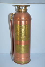
Rock Island RR Large Copper and Brass Fire ExtinguisherJM Hobby Supply and Railroad Artifact Auctions4.4(127)See Sold PriceFeb 24, 2024
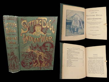
1891 Sitting Bull 1st ed Life Native American Sioux Indians DAKOTA Ghost DanceSchilb Antiquarian Rare Books4.8(428)See Sold PriceMar 10, 2024
LARGE LATE 17TH C. DUTCH CHART OF CANADA, GREAT LAKES, NEW FRANCE, LABRADOR, HUDSON BAY, BY PIERREThomaston Place Auction Galleries4.4(393)See Sold PriceFeb 24, 2024
17TH C. WORLD MAP BY NICOLAES VISSCHER (NETHERLANDS, 1618-1709)Thomaston Place Auction Galleries4.4(393)See Sold PriceFeb 24, 2024
LATE 17TH C. FRENCH MAP OF THE NEW WORLD BY ALEXIS-HUBERT JAILLOT (1632-1712)Thomaston Place Auction Galleries4.4(393)See Sold PriceFeb 24, 2024
NICOLAES VISSCHER (NETHERLANDS, 1618-1709) MAP OF THE NEW WORLDThomaston Place Auction Galleries4.4(393)See Sold PriceFeb 24, 2024
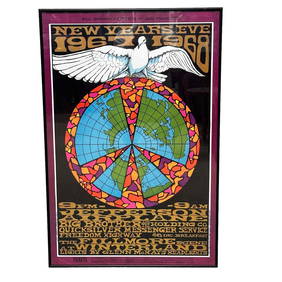
Vintage Jefferson Airplanes Big Brother New Years Eve 1967-68 Bill Graham Fillmore West ConcertPremier Auction Galleries4.4(331)See Sold PriceMar 09, 2024
Nova Totius Full Color Geographical World MapThe Benefit Shop Foundation Inc.4.3(2.9k)See Sold PriceFeb 28, 2024
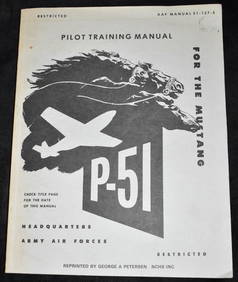
Pilot Training Manual for the P-51 Mustang (Restricted) 1945North American Artifact Auctions4.7(198)See Sold PriceApr 20, 2024
AMERICAN STILL LIFE OIL PAINTING BY GEORGE SCHULTZAntique Arena Inc.4.5(878)See Sold PriceFeb 24, 2024
[CIGARETTE CARDS]. HART, Frank (1856-1908). Between the Act...Potter & Potter Auctions4.6(545)See Sold PriceMar 07, 2024
[WORLD WAR I]. True Blue. Chicago: E.G. Renesch, 1919.Freeman's | Hindman4.4(1.6k)See Sold PriceFeb 27, 2024
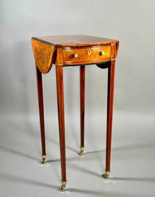
A Fine and Rare Small George III Rosewood and Satinwood Pembroke TableNeue Auctions4.6(357)See Sold PriceMar 02, 2024


![[CIGARETTE CARDS]. HART, Frank (1856-1908). Between the Act... (1 of 2)](https://p1.liveauctioneers.com/928/318880/171361520_1_x.jpg?height=282&quality=70&version=1707501302)
![[WORLD WAR I]. True Blue. Chicago: E.G. Renesch, 1919. (1 of 2)](https://p1.liveauctioneers.com/197/319238/171468135_1_x.jpg?height=282&quality=70&version=1707520367)