ATLAS of ANTIENT GEOGRAPHY by SAMUEL BUTLER 1843John McInnis Auctioneers,LLC4.5(505)See Sold PriceFeb 25, 2024
18TH C. ANTIQUE MAP: FRENCH & INDIAN WAR, FRAMEDThomaston Place Auction Galleries4.4(393)See Sold PriceFeb 24, 2024
Rand McNally Railroad Map Cabinet w/ 21 Railroad MapsRail & Road Auctions4.6(165)See Sold PriceMar 08, 2024
Keith Haring - Ink on New York Map, Best Buddies, Inscribed, Signed, and DatedSapphire Auction Gallery4(67)See Sold PriceMar 02, 2024
LATE 17TH C. FRENCH MAP OF THE NEW WORLD BY ALEXIS-HUBERT JAILLOT (1632-1712)Thomaston Place Auction Galleries4.4(393)See Sold PriceFeb 24, 2024
Central Railroad of New Jersey Map of Sandy Hook Route-ca. 1903JM Hobby Supply and Railroad Artifact Auctions4.4(127)See Sold PriceFeb 24, 2024
Lot of Six Mixed Atlas Box Cars-HO Scale-New in BoxJM Hobby Supply and Railroad Artifact Auctions4.4(127)See Sold PriceFeb 25, 2024
Rand McNally/Santa Fe Railroad Map of Iowa-1912JM Hobby Supply and Railroad Artifact Auctions4.4(127)See Sold PriceFeb 24, 2024
NICOLAES VISSCHER (NETHERLANDS, 1618-1709) MAP OF THE NEW WORLDThomaston Place Auction Galleries4.4(393)See Sold PriceFeb 24, 2024
17TH C. WORLD MAP BY NICOLAES VISSCHER (NETHERLANDS, 1618-1709)Thomaston Place Auction Galleries4.4(393)See Sold PriceFeb 24, 2024
Lot of Six Mixed Atlas Cabooses-HO Scale-New in BoxJM Hobby Supply and Railroad Artifact Auctions4.4(127)See Sold PriceFeb 25, 2024
A chart of magnetic curves of equal variation. World. GEORGE AIKMAN 1856 mapCAPTION PRINTED BELOW PICTURE: 'A chart of magnetic curves of equal variation' DATE PRINTED: 1856 IMAGE SIZE: Approx 28.0 x 42.5cm, 11 x 16.75 inches (Large) TYPE: Antique atlas map CONDITION: Good; sSee Sold Price
Aikman: Antique Map of World, Magnetic Curves, 1856TITLE/CONTENT OF MAP: 'A chart of magnetic curves of equal variation' DATE PRINTED: 1856 IMAGE SIZE: Approx 28.0 x 42.5cm, 11 x 16.75 inches (Large) TYPE: Antique atlas map CONDITION: Good; suitable fSee Sold Price
A chart of magnetic curves of equal variation. World.TITLE/CONTENT OF MAP: 'A chart of magnetic curves of equal variation' DATE PRINTED: 1856 IMAGE SIZE: Approx 28.0 x 42.5cm, 11 x 16.75 inches (Large) TYPE: Antique atlas map CONDITION: Good; suitable fSee Sold Price
A chart of magnetic curves of equal variation. World.TITLE/CONTENT OF MAP: 'A chart of magnetic curves of equal variation' The top image on the right hand side shows the entire map. To view a close up of the map showing the level of printed detail, pleaSee Sold Price
World chart of isothermal lines. Mean annual temperature. GEORGE AIKMAN 1856 mapCAPTION PRINTED BELOW PICTURE: 'Chart of isothermal lines, shewing the mean annual temperature of the different parts of the Earth's surface' DATE PRINTED: 1856 IMAGE SIZE: Approx 30.0 x 41.5cm, 11.75See Sold Price
Chart of Magnetic Curves of Equal Variation.Title/Content of Map: Chart of Magnetic Curves of Equal Variation. Date: 1847 Cartographer: BARLOW, PETER/G. AIKMAN Size: 9.75Height - 16Width Publisher: Adam & Charles Black Navigational chart of theSee Sold Price
Rivers and mountains. Physical geography. World. GEORGE AIKMAN 1856 old mapCAPTION PRINTED BELOW PICTURE: 'Physical geography' DATE PRINTED: 1856 IMAGE SIZE: Approx 28.5 x 39.5cm, 11.25 x 15.5 inches (Large) TYPE: Antique atlas map with original hand colouring / coloring CONSee Sold Price
The World, on Mercator's projection by GEORGE AIKMAN. Asia-centric 1856 mapCAPTION PRINTED BELOW PICTURE: 'The World, on Mercator's projection' DATE PRINTED: 1856 IMAGE SIZE: Approx 28.0 x 43.0cm, 11 x 16.75 inches (Large) TYPE: Antique atlas map with original hand colouringSee Sold Price
Magnetic curves of equal variation. 1846 by A and C BlackTitle: Magnetic curves of equal variation. 1846 by A and C Black Date/Period: 1846 Materials: Copperplate engraved Size: 12 x 17" Magnetic curves of equal variation, based on James R. Clark’s exSee Sold Price
World chart of isothermal lines. Mean annual temperature. GEORGE AIKMAN 1862 mapCAPTION PRINTED BELOW PICTURE: 'Chart of isothermal lines, shewing the mean annual temperature of the different parts of the Earth's surface' DATE PRINTED: 1862 IMAGE SIZE: Approx 30.0 x 42.0cm, 11.75See Sold Price
The World, on Mercator's projection by GEORGE AIKMAN.TITLE/CONTENT OF MAP: 'The World, on Mercator's projection' Date: 1856 IMAGE SIZE: Approx 28.0 x 43.0cm, 11 x 16.75 inches (Large) TYPE: Antique atlas map with original hand colouring / coloring CONDISee Sold Price
The World, on Mercator's projection by GEORGE AIKMAN.TITLE/CONTENT OF MAP: 'The World, on Mercator's projection' Date: 1856 IMAGE SIZE: Approx 28.0 x 43.0cm, 11 x 16.75 inches (Large) TYPE: Antique atlas map with original hand colouring / coloring CONDISee Sold Price
SoldFWOR Buffon (George Louis le Clerc, Comte de) CartFWOR Buffon (George Louis le Clerc, Comte de) Carte Magnétique des Deux Hemisphèrestwin-hemisphere world map designed to display magnetic variation, so centered on the North andSee Sold Price
SoldBuffon (G) Magnétique des HemisphèresBuffon (George Louis le Clerc, Comte de) Carte Magnétique des deux Hemisphères,twin-hemisphere world map designed to display magnetic variation, so centered on the North and South Poles, engraSee Sold Price
SoldColton's Atlas of the World Vol. II, 1856Title: Colton's Atlas of the World, Illustrating Physical and Political Geography... Author: Colton, George W. Description: Vol. II only. With 40 (of 42) hand-colored maps and charts (3 are double-pagSee Sold Price
SoldFramed Map Showing World Time And CurrencyUnique rendering of the world map showing variation in world time when 12 noon at Greenwich. Greenwhich time has Clock face in relief, Foreign money corresponding roughly with a shilling lines the perSee Sold Price
SoldChart of the World on Mercators ProjectionCirca 1796 Lot of 2 Antique World Maps; Titles: "Chart of the World on Mercators Projection" (Doolittle, sculp.) Approximate size: 11" x 8-3/8". "Map of the World from the best Authorities" (DoolittleSee Sold Price
SoldAJ Nystrom 2-Sided Chalkboard School Map, US & WorldLarge AJ Nystrom Roll Up 2 Sided Chalkboard Classroom Map Chart, US & World. Wonderful chart has maps of the United States and the World outlined in yellow on a black chalkboard backing. From the RoyaSee Sold Price
SoldChart of the World On Mercators Projection, 1796Map: Chart of the World On Mercators Projection Maker: Thomas & Andrews, Morse/Doolittle (Sculp) Publisher: Boston, 1796 Size: Quarto - 7.30 H x 10.00 W Inches Small map of the world. Shows LouisianaSee Sold Price
Sold1856 COLTON MAP CHARLESTON SCMap is from Colton's Atlas Of The World published by J.H. Colton And Company, 1856. Map was of Charleston, South Carolina and Savannah, Georgia. Framed with only Charleston showing. Professionally fraSee Sold Price
Sold1748 George Anson World Voyage 3 HUGE MAPS Spain South America Sea Navigation1748 George Anson World Voyage 3 HUGE MAPS Spain South America Sea Navigation George Anson was an 18th-century British Navy admiral who is noted for his important world voyage in which he circumnavigaSee Sold Price
SoldHUNDREDS Nautical, Geology & World Geography MapsAn historical estate collection consisting of hundreds of individual maps and charts, produced by and for various sources. Includes original U.S. Geological Survey maps, National Geographic Society woSee Sold Price
SoldA New and Correct Map of the World, circa 1700sA New and Correct Map of the World : laid down according to the newest observations & discoveries in several different projections including the trade winds, monsoons, variation of the compass, and ilSee Sold Price
Sold1761 George Anson Voyage Round the World MAPS Spain1761 George Anson Voyage Round the World MAPS Spain South America Brazil Peru George Anson was an 18th-century British Navy admiral who is noted for his important world voyage in which he circumnavigaSee Sold Price
LARGE LATE 17TH C. DUTCH CHART OF CANADA, GREAT LAKES, NEW FRANCE, LABRADOR, HUDSON BAY, BY PIERREThomaston Place Auction Galleries4.4(393)See Sold PriceFeb 24, 2024
17TH C. WORLD MAP BY NICOLAES VISSCHER (NETHERLANDS, 1618-1709)Thomaston Place Auction Galleries4.4(393)See Sold PriceFeb 24, 2024
LATE 17TH C. FRENCH MAP OF THE NEW WORLD BY ALEXIS-HUBERT JAILLOT (1632-1712)Thomaston Place Auction Galleries4.4(393)See Sold PriceFeb 24, 2024
RARE 1638 HONDIUS MAP OF BERMUDA, FRAMEDThomaston Place Auction Galleries4.4(393)See Sold PriceFeb 24, 2024
NICOLAES VISSCHER (NETHERLANDS, 1618-1709) MAP OF THE NEW WORLDThomaston Place Auction Galleries4.4(393)See Sold PriceFeb 24, 2024
MAP OF SALZBURG BY GEORGE BRAUN & FRANS HOGENBURG. 1588Thomaston Place Auction Galleries4.4(393)See Sold PriceFeb 24, 2024
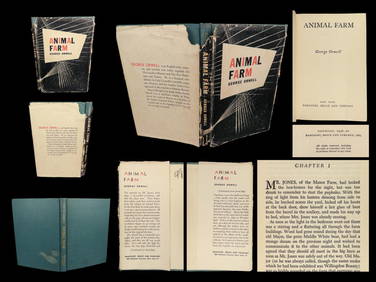
1946 Animal Farm George Orwell Bolshevik Revolution Dystopian Socialism DJSchilb Antiquarian Rare Books4.8(428)See Sold PriceMar 10, 2024
Vintage Full Color World Map LithographThe Benefit Shop Foundation Inc.4.3(2.9k)See Sold PriceFeb 28, 2024
Nova Totius Full Color Geographical World MapThe Benefit Shop Foundation Inc.4.3(2.9k)See Sold PriceFeb 28, 2024
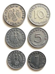
Lot of 3 German World War 2 Currency CoinsSouth Florida Auction & Estate Sale Services Inc4.5(522)See Sold PriceMar 08, 2024
American Girl Doll of Yesterday, Samantha + AccessoriesLion and Unicorn4.8(1.9k)See Sold PriceFeb 29, 2024
[WORLD WAR I]. True Blue. Chicago: E.G. Renesch, 1919.Freeman's | Hindman4.4(1.6k)See Sold PriceFeb 27, 2024
Carey, pub. 1796 - A Chart of the West IndiesTrillium Antique Prints & Rare Books4.5(32)See Sold PriceFeb 24, 2024
De Jode, Rare, pub. 1593 - Map of Africa (Africae Vera Forma, et Situs)Trillium Antique Prints & Rare Books4.5(32)See Sold PriceFeb 24, 2024
First Copy of Gautier's Le Roman de la Momie - 13 Original Watercolors by George Barbier (2 VolumesTrillium Antique Prints & Rare Books4.5(32)See Sold PriceFeb 24, 2024
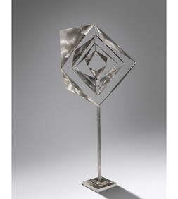
George Rickey (American, 1907-2002) Space Churn within Squares, Variation II, 1971Freeman's | Hindman4.4(1.6k)See Sold PriceMar 07, 2024
George Rodrique, American (1944-2013) LithographWorld Auction Gallery LLC4.7(264)See Sold PriceMar 10, 2024


![[WORLD WAR I]. True Blue. Chicago: E.G. Renesch, 1919. (1 of 2)](https://p1.liveauctioneers.com/197/319238/171468135_1_x.jpg?height=282&quality=70&version=1707520367)