SoldWillem Janszoon Blaeu /C. Mortie Map of RomeFine example of Joan Blaeu's plan of Rome, from Blaeu's Theatrum civitatum et admirandorum Italiae, first published in 1663.The present edition, re-issued by Mortier, includes a grid pattern, added toSee Sold Price
SoldWILLEM JANSZOON BLAEU 17TH/18TH C MAP OF BERMUDAWillem Janszoon Blaeu late 17th/early 18th century hand colored map of Bermuda. Titled "Mappa Aestivarum Insularum Alias Barmudas". Framed and matted in a burled wood finish frame. Condition: good conSee Sold Price
SoldVirginiae Partis australis, et Floridae partisWillem Janszoon Blaeu (1571-1638). Amsterdam, c. 1640. Engraved map with original hand color in part. 20 x 22 3/4 inches sheet, 29 1/2 x 32 1/4 inches framed.See Sold Price
Sold16TH C. MAP OF PERU16th century original colored map of Peru by Dutch cartographer Willem Janszoon Blaeu (1571-1638). Good condition, with some light foxing at edges and small tears at center crease edges. Framed and hoSee Sold Price
SoldRare Hand Colored and Engraved MapRare Hand-Colored and Engraved Map, "Virginiae partis australis, et Floridae partis orientalis, interjacentiumgus regionum Nova Descripto", by Willem Janszoon Blaeu, c. 1640. Matted and unframed.See Sold Price
Barchinona Map by Willem Janszoon Blaeu 17th C.Barchinona Map Engraving by Willem Janszoon Blaeu (Dutch Cartographer) 17th C. Image size: 15 x 19 inches.See Sold Price
ANTIQUE 17TH C MAP CASTILIA W. BLAEUAntique map of Castilia by W. Blaeu. Title: Utriusquae Castiliae Nova Descriptio. By: Willem Jansz. (also written Guilielmus Janssonius) -- Willem Janszoon Blaeu. Date of the first edition/map first pSee Sold Price
SoldFramed Colored Engraved 17th C. World Map"Nova Totius Terrarum Sive Novi Orbis Tabula" Framed Colored Engraved 17th C. World Map by Willem Janszoon Blaeu - This interesting piece is an early world map created by Willem Janszoon Blaeu. The maSee Sold Price
SoldMap "Nova Virginia Tabula" 17th century.Hand Colored map, by Willem Janszoon Blaeu. Amsterdam C. 1640, hand colored. Plate size 18.75" x 14 5/8", visible plate bite beyond those measurements. A very important and early map of the United StaSee Sold Price
Sold(2) 18TH C ENGRAVED MAPS - 'Hollandia Comitatus' by(2) 18TH C ENGRAVED MAPS - 'Hollandia Comitatus' by Willem Janszoon Blaeu (1571-1638), Amsterdam, circa 1635. The upper right corner inset with map of the isles Texel, Vlieland and Terschelling; PLUSSee Sold Price
1640 Dutch Map of the Spice IslandsA 1640 Dutch Map of the Spice Islands, "Moluccae Insulae Celeberrimae", Willem Janszoon Blaeu, Amsterdam c. 1640, with sea battles and whales, hand colored (HLAV1001) {TC} Property Title:From a DutchSee Sold Price
(2) 18TH C ENGRAVED MAPS - 'Hollandia Comitatus' by(2) 18TH C ENGRAVED MAPS - 'Hollandia Comitatus' by Willem Janszoon Blaeu (1571-1638), Amsterdam, circa 1635. The upper right corner inset with map of the isles Texel, Vlieland and Terschelling; PLUSSee Sold Price
SoldBlaeu French Regional Map, 17th C.Les Souverainetez de Sedan et de Raucourt et la prevosté de Doncheri. Willem Janszoon Blaeu (1571-1638). Joan Blaeu (1596-1673). Amsterdam: Mid 17th Century. Hand-colored engraving19 3/4 x 24 inchesSee Sold Price
SoldTwo Early Maps 1662, 1754Two Early Maps, Map of Asia, c.1662, Family of Willem Janszoon Blaeu, Dutch, ht. 20 1/2, wd. 23 1/4 & Nieuwe Kaart Van het Weftelykste Deel der Weereld, 1734 by IS. Tirion, ht. 15 3/4, wd. 18 1/2See Sold Price
SoldC 1640 Hollandia Comitatus Map W.J. BlaeuDESCRIPTION: Hollandia Comitatus. Map of the Netherlands. Latin text verso. Hand colored copperplate engraving. By Willem Janszoon Blaeu (1571-1638). Published in Amsterdam circa 1635 to 1640. MEASURESee Sold Price
SoldC 1640 Hollandia Comitatus Map W.J. BlaeuDESCRIPTION: Hollandia Comitatus. Map of the Netherlands. Latin text verso. Hand colored copperplate engraving. By Willem Janszoon Blaeu (1571-1638). Published in Amsterdam circa 1635 to 1640. MEASURESee Sold Price
SoldA 17th Century Map of Lithuania, Latvia, Poland,published c. 1662, Willem Janszoon Blaeu (1570–1630), cartouch reads 'Magni Ducatus Lithuaniae et Regionum Adiacentium exacta Descriptio . . . D.Nicolai Christopheri Radziwil . . .' detailed maSee Sold Price
SoldA Very Decorative Map of Poland with two Cartouches andPrinted in Amsterdam, Willem Janszoon (or Jansz.) Blaeu (1571 - 1638) , C. 1648, cartouch reads 'Polonia regnum et Silesia ducatus', copper plate engraving, hand coloured, untrimmed, map showing the rSee Sold Price
SoldA 17th Century Map of Poland, Including Coats of Arms,Published in Amsterdam, C.1635, Willem Janszoon Blaeu (1571-1638), cartouche reads ‘Polonia Regnum et Silesia Ducatus’ copper plate engraving, uncoloured, Latin text to verso, untrimmed,See Sold Price
(3) MAPS, BLAEU CHILI, GROELAND, ARROWSHITH CHILI(lot of 3) Framed maps: (1) "Partie du Groeland", 1827, Philippe Vandermalen (Belgium, 1795-1869), sight: 19"h, 22.5"w, overall: 30"h, 31"w; (1) "Chili", c. 1830, Willem Janszoon Blaeu (Dutch, 1570-16See Sold Price
SoldA 17th Century Decorative Map of Poland, IncludingWillem Janszoon Blaeu (1571-1638), Published in Amsterdam, C.1635, cartouche reads 'Polonia Regnum et Silesia Ducatus' coper plate engraving, uncoloured, latin Text to verso, dimensions 60.5cm x 50cmSee Sold Price
Guilielmo Blaeuw Antique Map Of Europe Vintage ReprintVintage reproduction of an antique map Europa recens descripta à Guilielmo Blaeuw which was first published in Amsterdam c 1630 by Willem Janszoon Blaeu and Joan Blaeu Original frame. Approximately 2See Sold Price
SoldTurcicum ImperiumWillem Janszoon Blaeu (1571-1638). Engraved map with original hand color. Amsterdam, c. 1638-40. 20 x 23 5/8 inchesSee Sold Price
Blaeu Map of VenezuelaVenezuela cum parte Australi Novae Andalusiae...Willem Janszoon Blaeu (1571-1638). Engraved map with original hand color. Amsterdam, c. 1640. 19 3/4 x 23 inches sheet.See Sold Price
17TH C. WORLD MAP BY NICOLAES VISSCHER (NETHERLANDS, 1618-1709)Thomaston Place Auction Galleries4.4(393)See Sold PriceFeb 24, 2024
LATE 17TH C. FRENCH MAP OF THE NEW WORLD BY ALEXIS-HUBERT JAILLOT (1632-1712)Thomaston Place Auction Galleries4.4(393)See Sold PriceFeb 24, 2024
17TH C. ANTIQUE MAP SIEGE OF LA ROCHELLE, FRANCE, FRAMEDThomaston Place Auction Galleries4.4(393)See Sold PriceFeb 24, 2024
EARLY 18TH C. MAP OF ITALY, FRAMEDThomaston Place Auction Galleries4.4(393)See Sold PriceFeb 24, 2024
LATE 16TH C. MAP OF SCOTLAND BY MERCATOR, FRAMEDThomaston Place Auction Galleries4.4(393)See Sold PriceFeb 24, 2024
17TH C. MAP OF THE BERKSHIRES BY JOHN SPEED, FRAMEDThomaston Place Auction Galleries4.4(393)See Sold PriceFeb 24, 2024
18TH C. ANTIQUE MAP: FRENCH & INDIAN WAR, FRAMEDThomaston Place Auction Galleries4.4(393)See Sold PriceFeb 24, 2024
17TH C. ENGLISH LINEAR MAP BY OGILBY, FRAMEDThomaston Place Auction Galleries4.4(393)See Sold PriceFeb 24, 2024
WILLEM JANSZOON BLAEU (NETHERLANDS, 1571-1638) MAP OF UMBRIAThomaston Place Auction Galleries4.4(393)See Sold PriceFeb 24, 2024
WILLEM JANSZOON BLAEU (NETHERLANDS, 1571-1638)Thomaston Place Auction Galleries4.4(393)See Sold PriceFeb 24, 2024
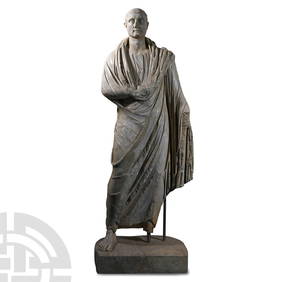
Roman Life-Size Marble Statue of an Important MagistrateTimeLine Auctions Ltd.4.6(183)See Sold PriceMar 05, 2024
Johann Homann Hand-Colored Map Engraving, c. 1730Auctions at Showplace4.6(740)See Sold PriceMar 17, 2024
Willem Blaeu, Etc. 17th C. Antiquarian Maps, 2Auctions at Showplace4.6(740)See Sold PriceMar 17, 2024
A quantity of World War II / Two military ephemera to include assorted 1940s newspapers pages toClaydon Auctioneers Ltd4.3(125)See Sold PriceFeb 26, 2024