ATLAS of ANTIENT GEOGRAPHY by SAMUEL BUTLER 1843John McInnis Auctioneers,LLC4.6(502)See Sold PriceFeb 24, 2024
18TH C. ANTIQUE MAP: FRENCH & INDIAN WAR, FRAMEDThomaston Place Auction Galleries4.4(386)See Sold PriceFeb 24, 2024
Rand McNally Railroad Map Cabinet w/ 21 Railroad MapsRail & Road Auctions4.6(165)See Sold PriceMar 08, 2024
Keith Haring - Ink on New York Map, Best Buddies, Inscribed, Signed, and DatedSapphire Auction Gallery4(67)See Sold PriceMar 02, 2024
LATE 17TH C. FRENCH MAP OF THE NEW WORLD BY ALEXIS-HUBERT JAILLOT (1632-1712)Thomaston Place Auction Galleries4.4(386)See Sold PriceFeb 24, 2024
Central Railroad of New Jersey Map of Sandy Hook Route-ca. 1903JM Hobby Supply and Railroad Artifact Auctions4.4(126)See Sold PriceFeb 24, 2024
Lot of Six Mixed Atlas Box Cars-HO Scale-New in BoxJM Hobby Supply and Railroad Artifact Auctions4.4(126)See Sold PriceFeb 25, 2024
Rand McNally/Santa Fe Railroad Map of Iowa-1912JM Hobby Supply and Railroad Artifact Auctions4.4(126)See Sold PriceFeb 24, 2024
NICOLAES VISSCHER (NETHERLANDS, 1618-1709) MAP OF THE NEW WORLDThomaston Place Auction Galleries4.4(386)See Sold PriceFeb 24, 2024
17TH C. WORLD MAP BY NICOLAES VISSCHER (NETHERLANDS, 1618-1709)Thomaston Place Auction Galleries4.4(386)See Sold PriceFeb 24, 2024
Lot of Six Mixed Atlas Cabooses-HO Scale-New in BoxJM Hobby Supply and Railroad Artifact Auctions4.4(126)See Sold PriceFeb 25, 2024
Willem Blaue, Carribean Map, C. 1635"Insulae Americanae in Oceano Septentrionali" 15" x 20.5" plate marks plus full margins. Light spot at center, but very good condition. An elegant sea chart of the Carribean region from the Dutch firmSee Sold Price
SoldWillem Blaue, Carribean Map, C. 1635"Insulae Americanae in Oceano Septentrionali" 15" x 20.5" plate marks plus full margins. Light spot at center, but very good condition. An elegant sea chart of the Carribean region from the Dutch firmSee Sold Price
Sold1635 AMERICAE NOVA TABULA, Map by Willem BlaeuHistoric MapsStunning 1635 Blaeu Map of North and South America c. 1635, Hand-Colored Map: "AMERICAE NOVA TABULA," by Willem Blaeu, (Amsterdam), Very Fine. This beautiful and highly ornate, oSee Sold Price
SoldWillem and Joan Blaeu MapWillem and Joan Blaeu (Dutch, 1571-1638 and 1596-1673), "Turcicum Imperium", Amsterdam, c. 1635, hand-colored map of the Ottoman Empire, from an edition of Theatrum Orbis Terrarum, 16 1/4 in. x 20 1/2See Sold Price
SoldWillem Blaeu 17th C. Map of FranceAuthor: Willem Blaeu Hand Colored Published in Amsterdam c.1635. "Les Souverainetez de Sedan et de Raucourt, et la Prevoste de Doncheri."See Sold Price
SoldBlaeu Map of CaribbeanBLAEU, Willem (1571-1638). Insulae Americanae in Oceano Septentrionali cum Terris Adiacentibus. Engraved map with hand color. Amsterdam: c. 1635. 18 1/2" x 23 1/3" sheet. Nice example of Blaeu's chartSee Sold Price
Sold(2) 18TH C ENGRAVED MAPS - 'Hollandia Comitatus' by(2) 18TH C ENGRAVED MAPS - 'Hollandia Comitatus' by Willem Janszoon Blaeu (1571-1638), Amsterdam, circa 1635. The upper right corner inset with map of the isles Texel, Vlieland and Terschelling; PLUSSee Sold Price
(2) 18TH C ENGRAVED MAPS - 'Hollandia Comitatus' by(2) 18TH C ENGRAVED MAPS - 'Hollandia Comitatus' by Willem Janszoon Blaeu (1571-1638), Amsterdam, circa 1635. The upper right corner inset with map of the isles Texel, Vlieland and Terschelling; PLUSSee Sold Price
SoldA 17th Century Decorative Map of Poland, IncludingWillem Janszoon Blaeu (1571-1638), Published in Amsterdam, C.1635, cartouche reads 'Polonia Regnum et Silesia Ducatus' coper plate engraving, uncoloured, latin Text to verso, dimensions 60.5cm x 50cmSee Sold Price
SoldBlaeu. TARTARIA MAGNI CHAMI IMPERIUM. [c. 1635].[Asia/China]. Willem & Jan Blaeu. TARTARIA MAGNI CHAMI IMPERIUM. [Amst: c. 1635]. 15 x 19 5/8 in. Double-page engraved map of China with rich detail including mountain ranges, forests, towns, and theSee Sold Price
SoldBLAEU, Willem (1571 - 1638). Nova Belgica et AngliBLAEU, Willem (1571 - 1638). Nova Belgica et Anglia Nova.[Amsterdam: c.1635 or later]. Double-page engraved map, hand-colored in outline (385 x 505 mm). French text on verso. Condition: lightlSee Sold Price
SoldMAP OF INDIA & SOUTHEAST ASIABy Willem Blaeu, ‘INDIA QUAE ORIENTALIS…’, Amsterdam, c. 1635, engraving with hand coloring, the map centered on the island of Java but showing all of Southeast Asia, India, and Southern Japan aSee Sold Price
SoldA 17th Century Map of Poland, Including Coats of Arms,Published in Amsterdam, C.1635, Willem Janszoon Blaeu (1571-1638), cartouche reads ‘Polonia Regnum et Silesia Ducatus’ copper plate engraving, uncoloured, Latin text to verso, untrimmed,See Sold Price
SoldPrincipatus Benearnia, La Principaute De Bearn.[France] Blaeu, Willem Janszoon (Dutch, 1571-1638). "Carte du Bourdelois, du Pais de Medoc, et de la Prevoste de Born" [on sheet with] "Principatus Benearnia. La Principaute de Bearn." c.1635-1662. HaSee Sold Price
SoldBlaeu. GUIANA SIVE AMAZONVM REGIO. [ca. 1635].[South America]. Willem Blaeu. GUIANA SIVE AMAZONVM REGIO. Amst: [c. 1635]. 14 5/8” x 19 ½”. Double-page engraved map, uncolored, with handsome foliated title cartouche, compass rose, engraved shSee Sold Price
SoldC 1640 Hollandia Comitatus Map W.J. BlaeuDESCRIPTION: Hollandia Comitatus. Map of the Netherlands. Latin text verso. Hand colored copperplate engraving. By Willem Janszoon Blaeu (1571-1638). Published in Amsterdam circa 1635 to 1640. MEASURESee Sold Price
SoldC 1640 Hollandia Comitatus Map W.J. BlaeuDESCRIPTION: Hollandia Comitatus. Map of the Netherlands. Latin text verso. Hand colored copperplate engraving. By Willem Janszoon Blaeu (1571-1638). Published in Amsterdam circa 1635 to 1640. MEASURESee Sold Price
SoldWillem Kip, Dutch act 1588-1635- ''SuffolciaeWillem Kip, Dutch act 1588-1635- ''Suffolciae Comitatus'' after Christopher Saxon, c.1607-1637; hand-coloured engraved map, 27.5x37.9cm: J C Walker, British 19th century- ''Suffolk''; hand-coloured enSee Sold Price
Blaeu: Antique Map of Italy & Islands, 1635Title: "Nova Italiae Delineatio", Beautiful mid-17th century hand-colored map of Italy and surrounding islands Map maker: Willem Janszoon Blaeu Place and Year: Amsterdam, c. 1635 Dimensions: 51.0 x 59See Sold Price
SoldJansson, Nova Belgica et Anglia Nova c.1636[United States: East Coast]. Johannes Jansson. Nova Belgica Et Anglia Nova. Double-page engraved map. c.1635 - 1660. 15 3/8 x 19 7/8 inches. Hand-colored outline, coloring to cartouche and scale.See Sold Price
SoldWILLEM BLAUE. (Dutch, 1571-1638). MAP OF GLOUCESTEWILLEM BLAUE. (Dutch, 1571-1638). MAP OF GLOUCESTER, Engraving with hand coloring. - 19 3/4 in. x 16 1/4 in., plate sizeSee Sold Price
SoldWILLEM BLAUE (Dutch, 1571-1638). MAP OF YORKSHIRE.WILLEM BLAUE (Dutch, 1571-1638). MAP OF YORKSHIRE. Engraving with hand coloring - 15 1/4 x 19 1/2 in., plate size.See Sold Price
SoldWILLEM BLAUE. (Dutch, 1571-1638). MAP OF NORTHHAMPWILLEM BLAUE. (Dutch, 1571-1638). MAP OF NORTHHAMPSHIRE, Engraving with hand coloring. - 19 3/4 in. x 16 1/4 in., plate sizeSee Sold Price
SoldWILLEM BLAUE (Dutch, 1571-1638). MAP OF NOTTINGHAMWILLEM BLAUE (Dutch, 1571-1638). MAP OF NOTTINGHAM, Engraving with hand coloring - 15 x 19 1/2 in., plate sizeSee Sold Price
17TH C. WORLD MAP BY NICOLAES VISSCHER (NETHERLANDS, 1618-1709)Thomaston Place Auction Galleries4.4(386)See Sold PriceFeb 24, 2024
LATE 17TH C. FRENCH MAP OF THE NEW WORLD BY ALEXIS-HUBERT JAILLOT (1632-1712)Thomaston Place Auction Galleries4.4(386)See Sold PriceFeb 24, 2024
17TH C. ANTIQUE MAP SIEGE OF LA ROCHELLE, FRANCE, FRAMEDThomaston Place Auction Galleries4.4(386)See Sold PriceFeb 24, 2024
EARLY 18TH C. MAP OF ITALY, FRAMEDThomaston Place Auction Galleries4.4(386)See Sold PriceFeb 24, 2024
LATE 16TH C. MAP OF SCOTLAND BY MERCATOR, FRAMEDThomaston Place Auction Galleries4.4(386)See Sold PriceFeb 24, 2024
17TH C. MAP OF THE BERKSHIRES BY JOHN SPEED, FRAMEDThomaston Place Auction Galleries4.4(386)See Sold PriceFeb 24, 2024
18TH C. ANTIQUE MAP: FRENCH & INDIAN WAR, FRAMEDThomaston Place Auction Galleries4.4(386)See Sold PriceFeb 24, 2024
17TH C. ENGLISH LINEAR MAP BY OGILBY, FRAMEDThomaston Place Auction Galleries4.4(386)See Sold PriceFeb 24, 2024
WILLEM JANSZOON BLAEU (NETHERLANDS, 1571-1638) MAP OF UMBRIAThomaston Place Auction Galleries4.4(386)See Sold PriceFeb 24, 2024
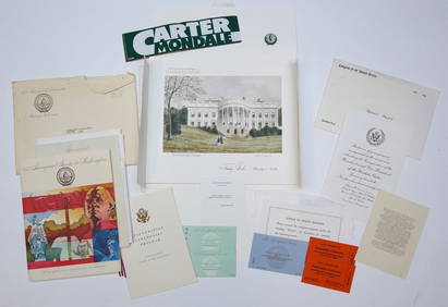
1977 INAUGURATION of PRESIDENT JIMMY CARTERJohn McInnis Auctioneers,LLC4.6(502)See Sold PriceFeb 25, 2024
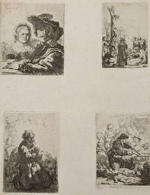
Rembrandt van Rijn. Four etchings, printed on one sheet of medium weight off-white wove paper, withTremont Auctions4.6(293)See Sold PriceFeb 25, 2024
Johann Homann Hand-Colored Map Engraving, c. 1730Auctions at Showplace4.5(726)See Sold PriceMar 17, 2024
Willem Blaeu, Etc. 17th C. Antiquarian Maps, 2Auctions at Showplace4.5(726)See Sold PriceMar 17, 2024
Two (2) Antique 18th C. Copper Engraved Framed Maps - America & EuropeMagnusson Art Group4.5(46)See Sold PriceMar 14, 2024
Perry, Matthew C. 1856 Large Map. Shah Bay, Lew Chew I. JapanAlbion Auctions4.6(336)See Sold PriceMar 01, 2024


![Blaeu. TARTARIA MAGNI CHAMI IMPERIUM. [c. 1635]. (1 of 5)](https://p1.liveauctioneers.com/179/49347/23134525_1_x.jpg?height=282&quality=70&version=1388425910)


![Blaeu. GUIANA SIVE AMAZONVM REGIO. [ca. 1635]. (1 of 5)](https://p1.liveauctioneers.com/179/49347/23134493_1_x.jpg?height=282&quality=70&version=1388425910)