ATLAS of ANTIENT GEOGRAPHY by SAMUEL BUTLER 1843John McInnis Auctioneers,LLC4.6(502)See Sold PriceFeb 24, 2024
18TH C. ANTIQUE MAP: FRENCH & INDIAN WAR, FRAMEDThomaston Place Auction Galleries4.4(386)See Sold PriceFeb 24, 2024
Rand McNally Railroad Map Cabinet w/ 21 Railroad MapsRail & Road Auctions4.6(165)See Sold PriceMar 08, 2024
Keith Haring - Ink on New York Map, Best Buddies, Inscribed, Signed, and DatedSapphire Auction Gallery4(67)See Sold PriceMar 02, 2024
LATE 17TH C. FRENCH MAP OF THE NEW WORLD BY ALEXIS-HUBERT JAILLOT (1632-1712)Thomaston Place Auction Galleries4.4(386)See Sold PriceFeb 24, 2024
Central Railroad of New Jersey Map of Sandy Hook Route-ca. 1903JM Hobby Supply and Railroad Artifact Auctions4.4(126)See Sold PriceFeb 24, 2024
Lot of Six Mixed Atlas Box Cars-HO Scale-New in BoxJM Hobby Supply and Railroad Artifact Auctions4.4(126)See Sold PriceFeb 25, 2024
Rand McNally/Santa Fe Railroad Map of Iowa-1912JM Hobby Supply and Railroad Artifact Auctions4.4(126)See Sold PriceFeb 24, 2024
NICOLAES VISSCHER (NETHERLANDS, 1618-1709) MAP OF THE NEW WORLDThomaston Place Auction Galleries4.4(386)See Sold PriceFeb 24, 2024
17TH C. WORLD MAP BY NICOLAES VISSCHER (NETHERLANDS, 1618-1709)Thomaston Place Auction Galleries4.4(386)See Sold PriceFeb 24, 2024
Lot of Six Mixed Atlas Cabooses-HO Scale-New in BoxJM Hobby Supply and Railroad Artifact Auctions4.4(126)See Sold PriceFeb 25, 2024
Western Part of the Southern Coast of Long IslandTitle/Content of Map: Western Part of the Southern Coast of Long Island Cartographer: BACHE, A.D./HASSLER, F.R. Date: 1851 Publisher: U.S. COAST SURVEY Size: 24.5Height - 35Width Rare. Details from HeSee Sold Price
Western Part of the Southern Coast of Long IslandPublication Date: 1851 Title: Western Part of the Southern Coast of Long Island Cartographer: BACHE, A.D./HASSLER, F.R. Publisher: U.S. COAST SURVEY Height: 24.5 Width: 35 Rare. Details from HempsteadSee Sold Price
1851 U.S. Coastal Survey Print Long IslandU.S. Coastal Survey Print, Western Part of the Southern Coast of Long Island, published 1851, Aids to Navigation Corrected to 1888, R. Bache, lieutenant USN, A.S. Baldwin, lieutenant USN, & M. WoodhulSee Sold Price
1851 U.S. Coastal Survey Print Long IslandU.S. Coastal Survey Print, Western Part of the Southern Coast of Long Island, published 1851, Aids to Navigation Corrected to 1888, R. Bache, lieutenant USN, A.S. Baldwin, lieutenant USN, & M. WoodhulSee Sold Price
S.W. Long Island Captain's Sea ChartBache, Alexander D. (1806-1867) & Hassler, Ferdinand R. (1770-1843). Western Part of the Southern Coast of Long Island. Engraved map. U. S. Coast Survey, 1851. 24 ½" x 35" sheet. Rare. Details fromSee Sold Price
Eastern Part of the Southern Coast of Long Island...Title: Eastern Part of the Southern Coast of Long Island... Publication Date: 1857 Cartographer: HASSLER, F.R.Publisher: U.S. COAST SURVEY Size: 24.6Height - 35Width ... from a Trigonometrical surveySee Sold Price
Middle Part of the Southern Coast of Long Island...Publication Date: 1857 Title: Middle Part of the Southern Coast of Long Island... Cartographer: HASSLER, F.R. Publisher: U.S. COAST SURVEY Height: 24.5 Width: 34.5 ... from a Trigonometrical survey unSee Sold Price
1857 Original Long Island ChartLong Island chart titled as the "middle part of the southern coast of Long Island" published in 1857. The chart shows Moriches Bay, Shinnecock Bay, Mecox Bay, Georgia Pond, Bridgehampton and EasthamptSee Sold Price
Five Views of Montauk Point LighthouseHassler, Ferdinand R. (1770-1843). Eastern Part of the Southern Coast of Long Island... Engraved map. U.S. Coast Survery, 1857. 24 â…" x 35" sheet. ... from a Trigonometrical survey under the direcSee Sold Price
1857 U.S. Coastal Survey Print Long IslandU.S. Coastal Survey Print, Middle Part of the Southern Coast of Long Island, published 1857, A.D. Bache, Superintendent, overall 28-3/4 x 38-1/2""See Sold Price
1857 U.S. Coastal Survey Print Long IslandU.S. Coastal Survey Print, Eastern Part of the Southern Coast of Long Island, published 1857, A.D. Bache, Superintendent, overall 30 x 38""See Sold Price
1857 U.S. Coastal Survey Print Long IslandU.S. Coastal Survey Print, Eastern Part of the Southern Coast of Long Island, published 1857, A.D. Bache, Superintendent, overall 30-3/4 x 39-1/2""See Sold Price
SoldChart of Long Island Sound - Western PartOriginal chart of the Connecticut and NewYork coast of Long Island Sound. Showing the Connecticut coast from Stratford to New York City. Dated 1932. Nicely framed. 35 x 46See Sold Price
Massive Long Island Sound Coast ChartHassler, Ferdinand R. (1770-1843), & U.S. Coast Survery. Eastern Part of Long Island Sound | Middle Part of Long Island Sound | Western Long Island Sound Three engraved maps. GPO, 1855. 105" wide if aSee Sold Price
Sold3-sheet chart of Long Island Sound 1855Title: Long Island Sound. Western Sheet [in set with] Middle Part of Long Island Sound [and] Eastern Part of Long Island Sound Author: U.S. Coast Survey Description: Together, 3 sheet forming one largSee Sold Price
Eastern Part of Long Island Sound | Middle Part of LongPublication Date: 1855 Title: Eastern Part of Long Island Sound | Middle Part of Long Island Sound | Long Island Sound (Western Sheet) Cartographer: U.S. COAST SURVEY/F. R. HASSLER Publisher: GPO WestSee Sold Price
Eastern Part of Long Island Sound | Middle Part of LongTitle/Content of Map: Eastern Part of Long Island Sound | Middle Part of Long Island Sound | Long Island Sound (Western Sheet) Cartographer: U.S. COAST SURVEY/F. R. HASSLER Date: 1855 Publisher: GPO SSee Sold Price
SoldHolland, Map of Western Long IslandHOLLAND, Samuel (1728-1801). The Seat of Action between the British and American Forces or An Authentic Plan of the Western Part of Long Island, with the Engagement of the 27th August 1776 between TheSee Sold Price
The seat of action, between the British and America81. Map: Robert Sayer and John Bennett, London, 1776 (Nebenzhl #108) The seat of action, between the British and American forces, or a plan of the western part of Long Island, with the engagement of tSee Sold Price
Sold1 piece. Partly Hand-Colored Engraved Map. Sayer,1 piece. Partly Hand-Colored Engraved Map. Sayer, Robert; Bennett, John, pub. The Seat of Action between The British and American Forces or, An Authentic Plan of The Western Part of Long Island, withSee Sold Price
SoldEarly 1900's George W. Eldridge Harbor ChartHarbor chart by George W. Eldridge from the early 1900's showing the southern coast of Connecticut and Long Island, NY. Highlights include Shelter Island, Peconic Bay, New Haven, Orient Point and otheSee Sold Price
South Coast of Long Island, U.S. Coastal Survey 1857Domestic: Free Shipping Map Title: Middle Part of the South Coast of Long Island, U.S. Coastal Survey Date: 1857 Medium: Steelplate engraved chart Size: 34.5 x 24.5 inches Showing the topography of thSee Sold Price
SoldColton folding map of Long Island 1872Heading: Author: Colton, George Woolworth and Charles B. Colton Title: Map of Long Island and the Southern Part of Connecticut Place Published: New York Publisher:Published by G.W. & C.G. Colton & CoSee Sold Price
Sold8 Railroad Logo Belt BucklesEight railroad logo belt buckles, all in brass including: Great Northern Railway, Rio Grande, The Long Island R.R. Co., Southern Pacific, Western Pacific, Union Pacific (marked Tiffany Studio on back)See Sold Price
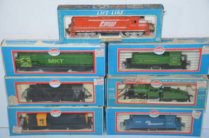
Seven Different Running Diesel Locomotives-Life-Like/Model Power-HO ScaleJM Hobby Supply and Railroad Artifact Auctions4.4(126)See Sold PriceFeb 25, 2024
CHART "SOUTHERN COAST OF LONG ISLAND FROM MONTAUK POINT TO EAST HAMPTON" Circa 1877 11.25" x 22.75"Eldred's4.7(409)See Sold PriceFeb 27, 2024
Group of Ten Railroad Photographs, Maps, and Prints - New Jersey, Long Island, and New YorkRail & Road Auctions4.6(165)See Sold PriceMar 07, 2024
1887 Appletons' General Guide to the United State and Canada Part IIRail & Road Auctions4.6(165)See Sold PriceMar 08, 2024
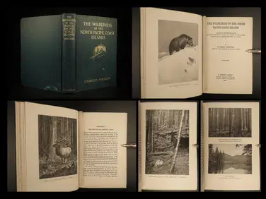
1912 HUNTING Alaska Vancouver Sheldon Wilderness of North Pacific Canada BearSchilb Antiquarian Rare Books4.8(421)See Sold PriceMar 31, 2024
Scalamandre Window Treatments, Curtains, Drapery Rainbow Stripe, Fringed, LinedJasper524.5(9.8k)See Sold PriceFeb 28, 2024
Single Cream Curtain on Valance, Window Treatment, DraperyJasper524.5(9.8k)See Sold PriceFeb 28, 2024
French Solid Bronze Six Light Chandelier, Canopy, Chain, Estate ItemJasper524.5(9.8k)See Sold PriceFeb 28, 2024
Louis XVI 19th Century Dore Bronze Chandelier, Six Light, Estate ItemJasper524.5(9.8k)See Sold PriceFeb 28, 2024
Afrique. Benguela #44. Southern Angola & Northern Namibia. VANDERMAELEN 1827 mapJasper524.5(9.8k)See Sold PriceFeb 28, 2024
Partie de la Coste d'Afrique'. Southern Mauritania BELLIN/SCHLEY 1747 old mapJasper524.5(9.8k)See Sold PriceFeb 28, 2024
Partie Occidentale de l’Afrique. West Africa coast Canary islands BONNE 1788 mapJasper524.5(9.8k)See Sold PriceFeb 28, 2024
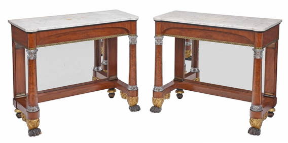
Rare Pair of American Classical Cut Glass Mounted and Gilt Stenciled Burlwood Pier TablesBrunk Auctions4.6(463)See Sold PriceMar 08, 2024
Lot of Mid Western Sterling Silver JewelryWorld Auction Gallery LLC4.7(261)See Sold PriceMar 10, 2024
Lot Native American & Mid Western Silver JewelyWorld Auction Gallery LLC4.7(261)See Sold PriceMar 10, 2024
Rare 19th Century Paris Porcelain Cup & SaucerWorld Auction Gallery LLC4.7(261)See Sold PriceMar 10, 2024
Antique Japanese Chawan Raku Style Tea BowlWorld Auction Gallery LLC4.7(261)See Sold PriceMar 10, 2024