ATLAS of ANTIENT GEOGRAPHY by SAMUEL BUTLER 1843John McInnis Auctioneers,LLC4.6(502)See Sold PriceFeb 24, 2024
18TH C. ANTIQUE MAP: FRENCH & INDIAN WAR, FRAMEDThomaston Place Auction Galleries4.4(386)See Sold PriceFeb 24, 2024
Rand McNally Railroad Map Cabinet w/ 21 Railroad MapsRail & Road Auctions4.6(165)See Sold PriceMar 08, 2024
Keith Haring - Ink on New York Map, Best Buddies, Inscribed, Signed, and DatedSapphire Auction Gallery4(67)See Sold PriceMar 02, 2024
LATE 17TH C. FRENCH MAP OF THE NEW WORLD BY ALEXIS-HUBERT JAILLOT (1632-1712)Thomaston Place Auction Galleries4.4(386)See Sold PriceFeb 24, 2024
Central Railroad of New Jersey Map of Sandy Hook Route-ca. 1903JM Hobby Supply and Railroad Artifact Auctions4.4(126)See Sold PriceFeb 24, 2024
Lot of Six Mixed Atlas Box Cars-HO Scale-New in BoxJM Hobby Supply and Railroad Artifact Auctions4.4(126)See Sold PriceFeb 25, 2024
Rand McNally/Santa Fe Railroad Map of Iowa-1912JM Hobby Supply and Railroad Artifact Auctions4.4(126)See Sold PriceFeb 24, 2024
NICOLAES VISSCHER (NETHERLANDS, 1618-1709) MAP OF THE NEW WORLDThomaston Place Auction Galleries4.4(386)See Sold PriceFeb 24, 2024
17TH C. WORLD MAP BY NICOLAES VISSCHER (NETHERLANDS, 1618-1709)Thomaston Place Auction Galleries4.4(386)See Sold PriceFeb 24, 2024
Lot of Six Mixed Atlas Cabooses-HO Scale-New in BoxJM Hobby Supply and Railroad Artifact Auctions4.4(126)See Sold PriceFeb 25, 2024
SoldWarren's Memoir on his large map of the WestHeading: Author: Warren, Gouverneur K. Title: Memoir to accompany the map of the territory of the United States from the Mississippi River to the Pacific Ocean, giving a brief account of each of theSee Sold Price
SoldLarge map of the American West, 1859Title: Map of the Territory of the United States from the Mississippi to the Pacific Ocean...to accompany the Reports of the Explorations for a Railway Route... Author:Warren, Gouverneur K. DescriptioSee Sold Price
Large map of the American West, 1857Heading: Author: Warren, Gouverneur K. Title: Map of the Territory of the United States from the Mississippi to the Pacific Ocean... to accompany the Reports of the Explorations for a Railway Route..See Sold Price
SoldLarge map of the American West, 1857Heading: United States) Author: Warren, Gouverneur K. Title: Map of the Territory of the United States from the Mississippi to the Pacific Ocean... to accompany the Reports of the Explorations for a RSee Sold Price
Reduced Map of the Territory West of the RockyTitle/Content of Map: Reduced Map of the Territory West of the Rocky Mountains by Capt. B.L.E. Bonneville U.S.A. 1837 Date: c1861 Cartographer: LT. WARREN'S MEMOIR PLATE IV Publisher: J. BIEN Size: 7HSee Sold Price
SoldLarge map of West Africa c.1700Heading: (Africa) Author: De l'Isle, Guillaume Title: Carte de la Barbarie de la Nigritie et de la Guinée Place Published: Paris Publisher: Date Published: c.1700 Description:See Sold Price
SoldLarge map of West Indies 1740Heading: (Caribbean) Author: Moll, Herman & Robert Morden Title: A New Mapp of the West-Indies or the Islands of America in the North Sea; Together with the adjacent Dominions; Explaining what belongsSee Sold Price
SoldWarren maps the West for Pacific Railroad Survey 1857Heading: Author: Warren, Gouverneur K. Title: Map of the Territory of the United States from the Mississippi to the Pacific Ocean... to accompany the Reports of the Explorations for a Railway Route..See Sold Price
SoldLarge Map of South West Africa This item is availableLarge Map of South West Africa This item is available for in house shipping contact Maria 561-351-2013 or email gidgett63@gmail.comSee Sold Price
Large Map of Virginia & West VirginiaMap of Virginia & West Virginia With map of Ohio [and] Indiana on versos Cartographer: George Franklin Cram Dated: Circa 1900 Type: Color Lithograph<See Sold Price
Large Map of Virginia & West VirginiaMap of Virginia & West Virginia With map of Ohio [and] Indiana on versos Cartographer: George Franklin Cram Dated: Circa 1900 Type: Color Lithograph<See Sold Price
Large Map of Virginia & West VirginiaMap of Virginia & West Virginia With map of Ohio [and] Indiana on versos Cartographer: George Franklin Cram Dated: Circa 1900 Type: Color LithogrSee Sold Price
Large Map of Virginia & West VirginiaMap of Virginia & West Virginia With map of Ohio [and] Indiana on versos Cartographer: George Franklin Cram Dated: Circa 1900 Type: Color LithogrSee Sold Price
Sold1867 Johnson Map of the Carribean/West Indies --Title/Content of Map: 1867 Johnson Map of the Carribean/West Indies -- Johnson's West Indies Date: 1867, New York Cartographer: A Johnson Size: 15 X 21.3 in. This is a superb, large map of the West InSee Sold Price
Reduced Section of a Sketch of the Western Part Of theTitle/Content of Map: Reduced Section of a Sketch of the Western Part Of the Continent Of North America Date Printed: 1861 ca. Cartographer: LT. WARREN'S MEMOIR PLATE II Size: 7X8 Map showing rivers,See Sold Price
Anville (J B B d) Cote de L'AfriqueAnville (J B B d) Carte Particuliere de la Cote Occidentale de L'Afrique, large engraved map of the west coast of Africa, on two sheets, with outline hand-colouring, each sheet 505 x 695mm., rSee Sold Price
West Virginia, 1898Large, greatly detailed map of West Virginia Map by Rand McNally, 1898. Printed in color, also shows western parts of Virginia. Dimensions: 28" x 21"See Sold Price
SoldLarge folding map of the American West 1867Heading: Author: Keeler, William J. Title: National Map of the Territory of the United States from the Mississippi River to the Pacific Ocean. Made by the authority of the Hon. O.H. Browning SecretarSee Sold Price
1901 - West Texas - XTRA Large Map1901 - West Texas - XTRA Large Map **|**|** This is a beautiful, 114 year old map of West Texas - published in the USA by George F. Cram. The map is much larger than most atlas maps of the same era. TSee Sold Price
1901 - West Texas - XTRA Large Map1901 - West Texas - XTRA Large Map **|**|** This is a beautiful, 114 year old map of West Texas - published in the USA by George F. Cram. The map is much larger than most atlas maps of the same era. TSee Sold Price
SoldCram: Antique Map of the West Indies, 1892West Indies. Cram's large, highly detailed map of the West Indies from his Superior Atlas of the World features shipping routes and undersea cables. On the verso are two separate maps: "Jamaica, HaitiSee Sold Price
Sold1828 Leather Set Columbus Voyages MapsHistoire De La Vie Et Des Voyages De Christophe Colomb, by Washington Irving, printed at Paris by Charles Gosselin. Four volume set including the two large folding tinted maps of the West Indies. TreeSee Sold Price
SoldBartholomew, John 1922 Lot of 8 Large Maps of EuropeIncl Belgium/Holland, Spain/Portugal - East & West, Northern Italy/Austria, Southern Italy, Central European States, Germany - South & West. Large Lithograph Maps Published 1922 by The Times, London fSee Sold Price
SoldGross, Alexander 1920 Mixed Lot of 5 Large MapsIncl British Island Possessions, Centrel America & Panama, Indian Ocean, Central Asia, and Russia - South West. Large Lithograph Maps Published 1920, London for "The Daily Telegraph Victory Atlas of tSee Sold Price
Mexico, Central America and West Indies Physical PoliticalJasper524.5(9.8k)See Sold PriceFeb 27, 2024
Pre-colonial Africa. Mountains of Kong/Moon. Caravan routes. THOMSON 1817 mapJasper524.5(9.8k)See Sold PriceFeb 28, 2024
WEST AFRICA. French. Gold Coast Ghana. inset Gambia; Sierra Leone 1920 mapJasper524.5(9.8k)See Sold PriceFeb 28, 2024
Côte occidentale de l'Afrique. W Africa.Senegal Gambia rivers.D’ANVILLE 1751 mapJasper524.5(9.8k)See Sold PriceFeb 28, 2024
CAP VERT. French/Portuguese Guinea Gambia Senegal Sierra Leone 1947 old mapJasper524.5(9.8k)See Sold PriceFeb 28, 2024
North-west Africa. Morocco &c. Sahara desert. Unresolved borders. TIMES 1922 mapJasper524.5(9.8k)See Sold PriceFeb 28, 2024
NIGERIA explorers' routes. Lander Clapperton Oudney Denham Allen. SDUK 1874 mapJasper524.5(9.8k)See Sold PriceFeb 28, 2024
WEST AFRICA II. NIGERIA. Bight of Benin-Lake Chad. Yariba Houssa. SDUK 1851 mapJasper524.5(9.8k)See Sold PriceFeb 28, 2024
Gulf of Guinea. Ghana Togo Benin Nigeria. ADMIRALTY sea chart 1928 (1954) mapJasper524.5(9.8k)See Sold PriceFeb 28, 2024
Colonial & French West Africa. Gold Coast Dahomey Upper Volta. TIMES 1922 mapJasper524.5(9.8k)See Sold PriceFeb 28, 2024
South Namibia coast. Walvis Bay-Orange River ADMIRALTY sea chart 1881 (1954) mapJasper524.5(9.8k)See Sold PriceFeb 28, 2024
Colonial West Africa. Nigeria Cameroon Congo. British German. TIMES 1900 mapJasper524.5(9.8k)See Sold PriceFeb 28, 2024
NIGERIA early explorers' routes. Lake Chad. Yariba Houssa Borgou SDUK 1844 mapJasper524.5(9.8k)See Sold PriceFeb 28, 2024
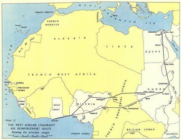
West Africa WW2 Nigeria Sudan Egypt. Takoradi air reinforcement route 1954 mapJasper524.5(9.8k)See Sold PriceFeb 28, 2024
FRENCH WEST AFRICA Nigeria Gold Coast Rio de Oro Portuguese Guinea 1912 mapJasper524.5(9.8k)See Sold PriceFeb 28, 2024
NIGERIA w/ early explorers' routes. Lake Chad Yariba Houssa Borgou.SDUK 1844 mapJasper524.5(9.8k)See Sold PriceFeb 28, 2024
NAMIBIA. South West Africa protectorate. HARMSWORTH 1920 old antique map chartJasper524.5(9.8k)See Sold PriceFeb 28, 2024
Colonial West Africa. Nigeria Cameroon Congo. British German. TIMES 1895 mapJasper524.5(9.8k)See Sold PriceFeb 28, 2024
L'Afrique Françoise ou du Senegal'. French West Africa. DE L’ISLE 1727 mapJasper524.5(9.8k)See Sold PriceFeb 28, 2024
Robert de Vaugondy - Map of Canada - Mer de l' Ouest or Sea of the West and a Northwest PassageProverde Auctions4.3(3)See Sold PriceFeb 28, 2024