ATLAS of ANTIENT GEOGRAPHY by SAMUEL BUTLER 1843John McInnis Auctioneers,LLC4.5(505)See Sold PriceFeb 24, 2024
18TH C. ANTIQUE MAP: FRENCH & INDIAN WAR, FRAMEDThomaston Place Auction Galleries4.4(393)See Sold PriceFeb 24, 2024
Rand McNally Railroad Map Cabinet w/ 21 Railroad MapsRail & Road Auctions4.6(165)See Sold PriceMar 08, 2024
Keith Haring - Ink on New York Map, Best Buddies, Inscribed, Signed, and DatedSapphire Auction Gallery4(67)See Sold PriceMar 02, 2024
LATE 17TH C. FRENCH MAP OF THE NEW WORLD BY ALEXIS-HUBERT JAILLOT (1632-1712)Thomaston Place Auction Galleries4.4(393)See Sold PriceFeb 24, 2024
Central Railroad of New Jersey Map of Sandy Hook Route-ca. 1903JM Hobby Supply and Railroad Artifact Auctions4.4(127)See Sold PriceFeb 24, 2024
Lot of Six Mixed Atlas Box Cars-HO Scale-New in BoxJM Hobby Supply and Railroad Artifact Auctions4.4(127)See Sold PriceFeb 25, 2024
Rand McNally/Santa Fe Railroad Map of Iowa-1912JM Hobby Supply and Railroad Artifact Auctions4.4(127)See Sold PriceFeb 24, 2024
NICOLAES VISSCHER (NETHERLANDS, 1618-1709) MAP OF THE NEW WORLDThomaston Place Auction Galleries4.4(393)See Sold PriceFeb 24, 2024
17TH C. WORLD MAP BY NICOLAES VISSCHER (NETHERLANDS, 1618-1709)Thomaston Place Auction Galleries4.4(393)See Sold PriceFeb 24, 2024
Lot of Six Mixed Atlas Cabooses-HO Scale-New in BoxJM Hobby Supply and Railroad Artifact Auctions4.4(127)See Sold PriceFeb 25, 2024
Reduced Section of a Sketch of the Western Part Of theTitle/Content of Map: Reduced Section of a Sketch of the Western Part Of the Continent Of North America Date Printed: 1861 ca. Cartographer: LT. WARREN'S MEMOIR PLATE II Size: 7X8 Map showing rivers,See Sold Price
Reduced Section of a Sketch of the Western Part Of theTitle: Reduced Section of a Sketch of the Western Part Of the Continent Of North America Prublication Date: c1861 Cartographer: LT. WARREN'S MEMOIR PLATE II Publisher: J. BIEN/LITH. Size: 7Height - 8WSee Sold Price
SoldSketch Map of the Western Part of the Plateau ProvinceReserve Reduced! Title: Sketch Map of the Western Part of the Plateau Province Showing The Faults Of The Grand Canyon District And High Plateau Publication Date: 1882 Cartographer: DUTTON, CLARENCE E.See Sold Price
1861 Map of Western US -- Reduced Section of a General Map of North America, Drawn from the BestTitle: 1861 Map of Western US -- Reduced Section of a General Map of North America, Drawn from the Best Surveys 1795 to Accompany Winterbothams History Cartographer: US Government - Senate Year / PlacSee Sold Price
SoldBowen (Emanuel) BarbaryBowen (Emanuel) Barbary,showing the eastern and western parts in two sections, engraved map with outline hand-colouring, 340 x 430mm, central vertical fold, c.1745; Nubia & Abissinia, engravedSee Sold Price
Map of the South Western and Part of the Western StatesReserve Reduced! Title: Map of the South Western and Part of the Western States Publication Date: 1847 Cartographer: SHERMAN & SMITH Publisher: D.F. ROBINSON Size (inches): 17.4Height - 10.5Width To iSee Sold Price
Sketch Map Showing the Distribution of the Strata andPublication Date: 1881 Title: Sketch Map Showing the Distribution of the Strata and Eruptive Rocks in The Western Part of The Plateau Province Cartographer: DUTTON, CLARENCE C. Publisher: U.S. GEOLOGISee Sold Price
Hutchins Map of the "Western Parts" of Virginia & Pennsylvania around the Ohio RiverHUTCHINS, Thomas (1730-1789). A New Map of the Western Parts of Virginia, Pennsylvania, Maryland and North Carolina. Folding engraved map laid down on cartographic linen in 32 sections, with originalSee Sold Price
SoldLuigiana Inglese US Deep South Louisiana MississippiReserve Reduced! TITLE/CONTENT OF MAP: 'Luigiana Inglese, colla parte Occidentale della Florida, della Giorgia, e Carolina Meridonale' "British Louisiana with the western part of Florida, Georgia, andSee Sold Price
United States South Central. Texas Louisiana Arkansas.TITLE/CONTENT OF MAP: 'United States. North America - The South Central Section comprising Texas, Louisiana, Mississippi, Arkansas, Western Territory and part of Missouri' Dallas is marked on the map;See Sold Price
Sketch J No. 2 Reconnoissance of the Western Coast ofReserve Reduced! Title: Sketch J No. 2 Reconnoissance of the Western Coast of the United States...1850 Publication Date: 1850 Cartographer: BACHE, A.D. Publisher: U.S. COAST SURVEY Size (inches): H8 -See Sold Price
La parte Occidentale della Nuova Francia o Canada. QCReserve Reduced! TITLE/CONTENT OF MAP: 'La parte Occidentale della Nuova Francia o Canada' "The western part of New France or Canada". The map shows part of western Quebec and north eastern Ontario beSee Sold Price
La parte Occidentale della Nuova Francia o Canada. QCReserve Reduced! TITLE/CONTENT OF MAP: 'La parte Occidentale della Nuova Francia o Canada' "The western part of New France or Canada". The map shows part of western Quebec and north eastern Ontario beSee Sold Price
"Parte del Regno d'Irlanda Connaught e Munster" WesternReserve Reduced! TITLE/CONTENT OF MAP: 'Parte del Regno d'Irlanda cioè le Provincie di Connaught, e Munster di nuova projezione' The western part of Ireland, being the Provinces of Connaught and MunsSee Sold Price
Parte Occidentale dell'Elvezia. Western Switzerland.Reserve Reduced! TITLE/CONTENT OF MAP: 'Parte Occidentale dell'Elvezia divisa ne'suoi Cantoni di Nuouva Projezione' The western part of the Confederation of Switzerland divided into its Cantons DATE PSee Sold Price
SoldPocket Map: WESTERN PART/EASTERN PART OF THE US[North America] Volume consisting of 2 folding maps: [1] WESTERN PART OF THE UNITED STATES OF AMERICA Including all its Newly Acquired Territory. 32 sections, each 10 5/8” x 4 ½”. [2nd] EASTERN PSee Sold Price
SoldHutchins Map of showing the course of the Ohio RiverHutchins, Thomas (1730-1789). A New Map of the Western Parts of Virginia, Pennsylvania, Maryland and North Carolina. Folding engraved map laid down on cartographic linen in 32 sections, with originalSee Sold Price
SoldFinest map of the southern East-Coast region of theA New Map of the Western Parts of Virginia, Pennsylvania, Maryland and North Carolina. Thomas Hutchins (1730-1789). Folding engraved map laid down on cartographic linen in 32 sections, with original hSee Sold Price
Soldc1910 UNITED STATES WESTERN SECTION Times AtlasThis antique map is part of a large collection we are selling during this auction - check out our other auctions to view more vintage and antique maps, prints and artwork. Buy more than one item and sSee Sold Price
SoldA very rare jousting lancedating: circa 1500 provenance: Germany, Short, iron head with three tips, with tapering ferrule (length 12 cm). Wooden haft, first part of round section, then a segment with reduced grip, the next parSee Sold Price
SoldBack To The Future Part III Stunt Colt Single ActionFrom "Back To The Future Part III" (1990), this is a screen used metal and wood stunt Colt Single Action Army .45 used by many characters in the "western period" section of the film. It is an exact reSee Sold Price
SoldU S Coast Survey 1896 LG Map. West USA California Texas"Sketch of General Progress June 30. 1896." Showing Central and Western US, with part of Mexico. From Mississippi/Wisconsin through to West Coast. Large Lithograph Map Published 1896, Washington for "See Sold Price
SoldA Chinese monochrome turquoise-glazed vase on stand,A Chinese monochrome turquoise-glazed vase on stand, 18th C. H.: 23 cm The neck reduced and silver-mounted, with small lacking sections to the upper parts of each handle. Provenance: A Dutch private cSee Sold Price
SoldWestern Asiatic Luristan Sceptre Part GroupLate 2nd millennium BC. A mixed group of bronze elements for a sceptre comprising: a flat-section panel with ram-head finial; a tapering tube with ribbed collar, two addorsed human faces; a finial witSee Sold Price
Atlantic and Pacific RY Annual Report-April 30, 1868JM Hobby Supply and Railroad Artifact Auctions4.4(127)See Sold PriceFeb 24, 2024
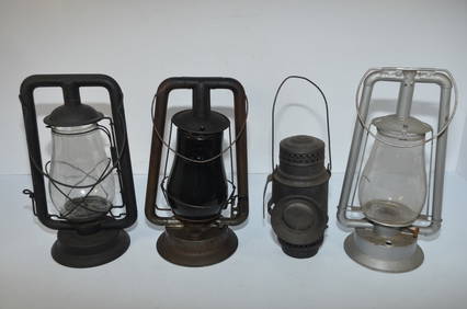
Four Mixed Tubular Lanterns-Aladdin/Defiance/E T Wright/Steam GaugeJM Hobby Supply and Railroad Artifact Auctions4.4(127)See Sold PriceFeb 24, 2024
Early Chinese Buddha-Over 1000 years old- Rare, BeautyThe Buddha Gallery4.4(29)See Sold PriceMar 13, 2024
15thC Sukhothai Walking Buddha Head-Museum quality. Near Monumental in Size!The Buddha Gallery4.4(29)See Sold PriceMar 13, 2024
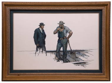
WILLIAM HENRY DETHLEF KOERNER (NJ/NY/MT, 1878-1938)Thomaston Place Auction Galleries4.4(393)See Sold PriceFeb 25, 2024
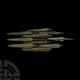
Western Asiatic Bronze Arrowheads, Javelin Heads and DaggersTimeLine Auctions Ltd.4.6(183)See Sold PriceMar 07, 2024
EVA LOOTZ (Vienna, 1940). Untitled, 1987. Mixed technique on paper. Attached to the back is a labelSetdart Auction House4(23)See Sold PriceMar 05, 2024
Partie Occidentale de l’Afrique. West Africa coast Canary islands BONNE 1788 mapJasper524.5(9.9k)See Sold PriceFeb 28, 2024
Colonial Central Africa. Belgian Congo. French Equatorial Africa. TIMES 1922 mapJasper524.5(9.9k)See Sold PriceFeb 28, 2024
Mel Brooks History of the world: Part 1 storyboard sketchesEagles Corps International LLC4.5(107)See Sold PriceMar 10, 2024
Disney Richard Harrison Green Sketch 101 DalmatiansRapid Estate Liquidators and Auction Gallery4.5(1.1k)See Sold PriceFeb 28, 2024