SoldWall map entitled "Map of Dutchess Co. New York fromWall map entitled "Map of Dutchess Co. New York from Actual Surveys, John E. Gillette, Publisher, 517, 519, 521, Minor Str. Philadelphia. 1858". Overall fair condition with tears, staining, paper lossSee Sold Price
SoldAtlas entitled "New Historical Atlas of Dutchess Co.Atlas entitled "New Historical Atlas of Dutchess Co. New York Illustrated" - Reading Publishing Co., Pennsylvania 1876. Complete with hand colored maps and prints of historical buildings/locations. LoSee Sold Price
SoldRollup wall map entitled "Map of Ulster Country NewRollup wall map entitled "Map of Ulster Country New York" from original surveys by Oliver J. Tillson & P. Henry Brink - dated 1853. 4' 6"W x 3' 5"H. Lithographed paper applied to canvas. Slight frayinSee Sold Price
SoldTwo large folio Poughkeepsie NY maps entitled "Map ofTwo large folio Poughkeepsie NY maps entitled "Map of the City of Poughkeepsie Dutchess County, New York" - From surveys under the supervision of "READING PUBLISHING HOUSE and Theodore W. Davis, C.E."See Sold Price
SoldRollup wall map of Dutchess County New York publishedRollup wall map of Dutchess County New York published by John E. Gillette, Philadelphia, 1858 - lithographed paper applied to canvas, several stains, several small holes approximately 1/2", but overalSee Sold Price
SoldWall map of Dutchess County New York by surveyor J.C.Wall map of Dutchess County New York by surveyor J.C. Sidney and published in 1850 by John E. Gillette. Some minor tears and staining but overall good condition. 40" x 58".See Sold Price
SoldWall map of Dutchess County New York from actualWall map of Dutchess County New York from actual surveys - John E. Gillette Phila. 1858 - 59" x 61". Poor condition with stains, losses, tears.See Sold Price
SoldAntique 1858 Wall Map,Dutchess County,NY Rhinebeck,EtcAntique 1858 Wall Map,Dutchess County,NY Rhinebeck,Etc. This Large detailed antique map of Dutchess county New York is dated 1858. This large map has lots of great little details including drawings anSee Sold Price
Antique Wall Map of Middle EastColton's One Sheet Map of the Lands Mentioned in the Bible. Colton, Ohman & Co., New York: 1885. Wall map on cloth. Eastern Europe, Turkey, Holy Land, Israel. 25 1/2" x 37".See Sold Price
SoldAntique Wall Map of Middle EastColton's One Sheet Map of the Lands Mentioned in the Bible. Colton, Ohman & Co., New York: 1885. Wall map on cloth. Eastern Europe, Turkey, Holy Land, Israel. 25 1/2" x 37".See Sold Price
SoldOld Map of 1873 "Colton's Dakota"Old Map entitled "Colton's Dakota". Purchased by the consignor as "an original hand colored tinted map from circa 1873". Published by G.W. (and) C.B. Colton & Co. No. 172 William St. New York. At bottSee Sold Price
Wall map, lithographed paper on canvas, of Ulster Co.Wall map, lithographed paper on canvas, of Ulster Co. New York - J.H. French 1868. Stains, loose paper, and losses (mostly at top).See Sold Price
SoldAtlas entitled "New Historical Atlas of Dutchess CAtlas entitled "New Historical Atlas of Dutchess Co. New York Illustrated" - Reading Publishing Co., Pennsylvania 1876. Complete with hand colored maps and prints of historical buildings/locations.See Sold Price
Political Wall Map Series By J. Paul Goode/ Rand McNally & Co., Chicago New York 1914Description: Political Wall Map Series By J. Paul Goode/ Rand McNally & Co., Chicago New York 1914. Material: Paper.See Sold Price
Sold2 Copies: TOPOGRAPHICAL MAP OF THE STATE... 1862.[Pennsylvania Wall Maps]. 2 copies: TOPOGRAPHICAL MAP OF THE STATE OF PENNSYLVANIA Drawn from Actual Surveys by H. F. Walling Published by Smith, Palmer & Co., No. 358 & 360 Pearl St. New York, & 27 SSee Sold Price
SoldMap Of The Town Of Northeast New YorkEarly map of "Town Of Northeast/Dutchess Co. N.Y.". Sight 17 1/2" x 14".See Sold Price
SoldC.S. Hammond & Co. Enlarged Railroad and County MapC.S. Hammond & Co. Enlarged Railroad and County Map of the United States with Portions of Canada and Mexico, 1912, New York, printed wall map on linen mounted on a tin roller, approx. 54 x 78 in. withSee Sold Price
SoldAn 1867 double hemispheric map of the world by A. J.An 1867 double hemispheric map of the world by A. J. Johnson entitled 'Globular Worlds', published by Alvin J. Johnson & Co., New York. Approx. 23 x 35''See Sold Price
SoldAntique Wall Map NEW YORK POSTAL ROUTES 1898 MailDetails: This large hanging wall map of postal routes in the state of New York was created by topographer A. von Haake, and printed by "Julius Bien & Co., Photo. Lith." Dated March, 1, 1898, this mapSee Sold Price
SoldAntique Wall Map, "Sidney's Map of Twelve Miles ArAntique Wall Map, "Sidney's Map of Twelve Miles Around New York with the Names of Property Holders & C.," (Philadelphia: H. Camp, 1849), hand colored folding map w/linen backing, shows Manhattan and eSee Sold Price
1777 Section Map of New-York New-Jersey byLotterHandcolored map entitled “A Map of the Provinces of New-York and New-Jersey with a Part of Pennsylvania and the Province of Quebec from the Topgraphical Observations of C.J. Sauthier”, printed atSee Sold Price
1855 Wall Map of US and MexicoMap of the United States with its Territories: Also Mexico and the West Indies … 1855 [Wall Map]. Lithographed wall map with hand color. New York: Ensign, Bridgman & Fanning, 1855. 36 1/2 x 35 1/2 iSee Sold Price
1892 Adams and Bowles New Road Map of the State of New YorkJM Hobby Supply and Railroad Artifact Auctions4.4(127)See Sold PriceFeb 24, 2024
Crams Railroad Map of New York-1881JM Hobby Supply and Railroad Artifact Auctions4.4(127)See Sold PriceFeb 24, 2024
Crams Township and Railroad Map of New York-1890JM Hobby Supply and Railroad Artifact Auctions4.4(127)See Sold PriceFeb 24, 2024
19thc Colton Map, Comparitive Size of Lakes & IslandsConnoisseur Auctions3.9(337)See Sold PriceFeb 24, 2024
ANSONIA CLOCK CO Antique Octagonal Clock USA 32inThe Benefit Shop Foundation Inc.4.3(3k)See Sold PriceFeb 28, 2024
Vintage County Map Of NY State Plate EngravingThe Benefit Shop Foundation Inc.4.3(3k)See Sold PriceFeb 28, 2024
1855 Map of New York & Erie Railroad and 1917 Trespassing On Railway Property Is A MisdemeanorRail & Road Auctions4.6(165)See Sold PriceMar 07, 2024
Keith Haring - Ink on New York Map, Best Buddies, Inscribed, Signed, and DatedSapphire Auction Gallery4.1(67)See Sold PriceMar 02, 2024
Set 4 SM Elite Limoges France Antq China PlatesThe Benefit Shop Foundation Inc.4.3(3k)See Sold PriceMar 06, 2024
1849 THE NEW-ENGLAND MERCANTILE UNIONNorth American Artifact Auctions4.7(201)See Sold PriceApr 20, 2024
Keith Haring Artwork Signed on a Shell Oil New York Road Map 18 in. x 24 in.Donny Malone Auctions4.5(1.8k)See Sold PriceMar 04, 2024
DE FOREST LEE: (1873-1961)International Autograph Auctions Europe S.L.4.5(55)See Sold PriceMar 13, 2024
Black and white map of part of New York City (mostly Manhattan)Proverde Auctions4.3(3)See Sold PriceFeb 28, 2024
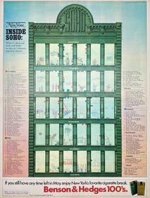
Map Inside Soho - Manhattan - New York Magazine 1974Proverde Auctions4.3(3)See Sold PriceFeb 28, 2024
Laminated Unique Media New York City MapRapid Estate Liquidators and Auction Gallery4.5(1.1k)See Sold PriceFeb 29, 2024