Sold2 Copies: TOPOGRAPHICAL MAP OF THE STATE... 1862.[Pennsylvania Wall Maps]. 2 copies: TOPOGRAPHICAL MAP OF THE STATE OF PENNSYLVANIA Drawn from Actual Surveys by H. F. Walling Published by Smith, Palmer & Co., No. 358 & 360 Pearl St. New York, & 27 SSee Sold Price
Sold2 Maps incl: Smith's Topographical Map Of Virginia[United States] 2 Maps. ++ Smith’s Topographical Map Of Virginia And Maryland. NY: J. C & Rae Smith. Undated but c. 1862. Folding amp of railroads, mountain ridges, and counties. Printed color. 2 inSee Sold Price
1850 map Boston Harbor & 1849 Florida plat map.[United States]. 2 Maps. ++ Copy Of Part Of Plan Of Inner Harbor Of Boston, Showing Commissioners Lines. Detailed folding map of Boston Harbor, with soundings. Based on the work of commissioners appoiSee Sold Price
Sold1862 Walling Pennsylvania Topographical Wall MapDESCRIPTION: 1862 Topographical Map of the State of Pennsylvania Drawn to the Actual Surveys by H.F. Walling. Published by Smith, Palmer & Co. Includes the following inset maps: Climatological Map bySee Sold Price
SoldLot of 2 Maps 1862 New Jersey & 1877 New YorkLot of 2 Early Maps from New York and New Jersey 1862 and 1877. 1.) 1862 Topographical Map of Cape May County New Jersey. Map measures 15 1/4” X 12 1/4”. Is matted and wrapped in plastic for an ovSee Sold Price
SoldGeneral Map of the United States of America, 1862[United States]. 2 Maps on 1 sheet: General Map of the United States of America, The British Provinces. Mexico. The West Indies and Central America, with part of New Granada and Venezuela. / G. WoolwoSee Sold Price
SoldConnecticut44. Connecticut.Clark & Tackabury's New Topographical Map of the State of Connecticut. Fine hand-colored map in 24 sections. 56-1/2 x 72 inches, linen-backed, gilt-lettered cloth portfolio with stringSee Sold Price
SoldThirteen 19th Century Maps of Alabamaincluding Finley's Alabama, 1829, 13-1/4 x 10-1/4 in.; Burr's Map of the States of Alabama, 1834, 14-3/4 x 11-3/8 in., 2 copies; Boynton's Alabama, 1838, 16 x 13 in.; Lucas' Alabama,See Sold Price
Colton Map of VirginiaCOLTON, J. H. (1800-1893).Colton's New Topographical Map of the States of Virginia, Maryland and Delaware...Lithographed map with original hand color in full.New York: Colton, 1862.32 3/4" x 46 1/4" sSee Sold Price
SoldColton's Map of the Southern States 1862 Civil WarColton's Map of the Southern States 1862 Civil War, hand-col. NY:1862 J.H. Colton400 Miles scaleDimensions: 40" X 39 1/2"Note: Includes 1860 United States Census. Linen backed._x000D_ Inv.42See Sold Price
Sold2- 100 Year Old Topographical Maps- Berkshires2- 100 Year Old Topographical Maps- BerkshiresSee Sold Price
Soldhandbook of alabamaTitle: Hand Book of Alabama: A Complete Guide to the State, with a Geologic Map and an Index of Useful Tables. (2 copies) Author: Berney, Saffold Description: Lot of 2 copies. 2 fl, (ix)-xxxix, 338 ppSee Sold Price
handbook of alabamaTitle: Hand Book of Alabama: A Complete Guide to the State, with a Geologic Map and an Index of Useful Tables. (2 copies) Author: Berney, Saffold Description: Lot of 2 copies. 2 fl, (ix)-xxxix, 338 ppSee Sold Price
SoldNew York State MapHand colored map of New York "A Topographical Map of the North Port / of / New York Island / now / Fort Knyphausen...", published in London...1777". Sight 17" x 9 1/2", overall 23 1/2" x 15 1/2".See Sold Price
5 vols. Various State Historical Collections.[Americana] 5 volumes. (1) 2 Copies. Howe, Henry. Historical Collections of Virginia. Babcock & Co., Charleston, S.C., 1845. (2) Barber, John W. Historical Collections of the State of New-York. Clark,See Sold Price
SoldReports of the State Mineralogist of California13 volumes. Second through Thirteenth Annual or Biennial Reports, including 2 copies of the Tenth Annual Report. Illustrated with maps, charts, plates, photographs, etc., including many folding. 6 inSee Sold Price
Sold3 Vintage maps1, Vintage maps topographical map of North and South Carolina, a large portion of Georgia and part of a joining states XL plate 1966, 2, Village map Panera of the sea of war Birdseye view of North CarSee Sold Price
Sold2 Books incl: ASHER & ADAMS' NEW... ATLAS, (1873).[Atlas] 2 Titles. Sold with all faults. ++ ASHER & ADAMS’ NEW STATISTICAL AND TOPOGRAPHICAL ATLAS OF THE UNITED STATES. With Maps Showing The Dominion of Canada, Europe and the World. Exhibiting a CSee Sold Price
1838 Bradford Map of Indiana -- IndianaTitle/Content of Map: 1838 Bradford Map of Indiana -- Indiana1838 BostonT Bradford14.2 x 11 in.This is a nice and highly detailed state map. The counties are color-coded, and topographical features anSee Sold Price
SoldTwo Copies of Johnson & Ward, "New Military Map of theTwo Copies of Johnson & Ward, "New Military Map of the United States," 1861, hand colored, H.- 17 7/8 in., W.- 26 3/4 in. (2 Pcs.)See Sold Price
Map of the State of Vermont.Duplicate maps mountedMap of the State of Vermont.Duplicate maps mounted recto and verso on 1 sheet of linen. 25-1/2 x 15-1/4 inches; chipped at margin, 1 copy with several counties colored. New York, Circa 1890sSee Sold Price
SoldTwo Copies of Samuel Augustus Mitchell (1790-1868),Two Copies of Samuel Augustus Mitchell (1790-1868), "Map of the United States," 1877, H. - 11 1/2 in., W. -15 in. (2 Pcs.)See Sold Price
Solddated 1673 very colorful map of the Northeast Unitedcopy of dated 1673 very colorful map of the Northeast United States - 19 1/2" x 21 1/2" sight size - Hadley EstateSee Sold Price
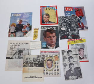
1966 DEC. R.F.K. FAMILY CHRISTMAS CARD etcJohn McInnis Auctioneers,LLC4.5(505)See Sold PriceFeb 25, 2024
Adriaen van Ostade. 19 etchings. 1) "The Barn". IX state. 2 examples. 2) "The Smoker and theTremont Auctions4.5(298)See Sold PriceFeb 25, 2024
1834 Rogers Poems, 1830 Rogers Italy Proof Copy First State First EditionDana J. Tharp Auctions4.7(271)See Sold PriceFeb 24, 2024
1867 Map of the Railroads of The State of New YorkRail & Road Auctions4.6(165)See Sold PriceMar 08, 2024
[BASEBALL]. [LINCOLN, Abraham (1809-1865), association]. “A...Potter & Potter Auctions4.6(550)See Sold PriceMar 07, 2024
1905 20th Century Atlas of Boone County IllinoisMatthew Bullock Auctioneers4.7(1.9k)See Sold PriceFeb 24, 2024
Putnam - First Map of the State of Ohio by Rufus PutnamTrillium Antique Prints & Rare Books4.5(33)See Sold PriceFeb 24, 2024
1862-R Italy Papal States Gold 2 1/2 Scudi Pius IX MS-66 NGCGolden Air Auctions4.3(267)See Sold PriceFeb 27, 2024
Map of United States of North America, 1785Antiques Online Auctions4.6(419)See Sold PriceMar 14, 2024


![[BASEBALL]. [LINCOLN, Abraham (1809-1865), association]. “A... (1 of 3)](https://p1.liveauctioneers.com/928/318880/171361381_1_x.jpg?height=282&quality=70&version=1707501302)


