ATLAS of ANTIENT GEOGRAPHY by SAMUEL BUTLER 1843John McInnis Auctioneers,LLC4.6(504)See Sold PriceFeb 24, 2024
18TH C. ANTIQUE MAP: FRENCH & INDIAN WAR, FRAMEDThomaston Place Auction Galleries4.4(389)See Sold PriceFeb 24, 2024
Rand McNally Railroad Map Cabinet w/ 21 Railroad MapsRail & Road Auctions4.6(165)See Sold PriceMar 08, 2024
Keith Haring - Ink on New York Map, Best Buddies, Inscribed, Signed, and DatedSapphire Auction Gallery4.1(67)See Sold PriceMar 02, 2024
LATE 17TH C. FRENCH MAP OF THE NEW WORLD BY ALEXIS-HUBERT JAILLOT (1632-1712)Thomaston Place Auction Galleries4.4(389)See Sold PriceFeb 24, 2024
Central Railroad of New Jersey Map of Sandy Hook Route-ca. 1903JM Hobby Supply and Railroad Artifact Auctions4.4(126)See Sold PriceFeb 24, 2024
Lot of Six Mixed Atlas Box Cars-HO Scale-New in BoxJM Hobby Supply and Railroad Artifact Auctions4.4(126)See Sold PriceFeb 25, 2024
Rand McNally/Santa Fe Railroad Map of Iowa-1912JM Hobby Supply and Railroad Artifact Auctions4.4(126)See Sold PriceFeb 24, 2024
NICOLAES VISSCHER (NETHERLANDS, 1618-1709) MAP OF THE NEW WORLDThomaston Place Auction Galleries4.4(389)See Sold PriceFeb 24, 2024
17TH C. WORLD MAP BY NICOLAES VISSCHER (NETHERLANDS, 1618-1709)Thomaston Place Auction Galleries4.4(389)See Sold PriceFeb 24, 2024
Lot of Six Mixed Atlas Cabooses-HO Scale-New in BoxJM Hobby Supply and Railroad Artifact Auctions4.4(126)See Sold PriceFeb 25, 2024
Sold1755 Large Wall Map of AfricaAfrica Performed by the Sr. Danville under the Patronage of the Duke of Orleans Revised and Improved by Mr. Bolton, a large map of Africa published in four sections, all present here, that can be combSee Sold Price
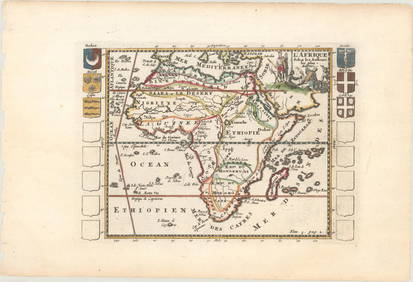
Sold[ 18th c. Wall Map of Africa][Fine 18th c. Wall Map of Africa], "Africa with All Its States, Kingdoms, Republics, Regions, Islands...", 1794, London, published by Laurie & Whittle, hand-colored engraved map, dissected and mountedSee Sold Price
1755 Bolton Section Wall Map of AfricaAfrica Performed by the Sr. Danville under the Patronage of the Duke of Orleans Revised and Improved by Mr. Bolton, a large map of Africa published in four sections, all present here, that can be combSee Sold Price
WALL MAP OF AFRICA 1797Wall map of Africa. Philippe Buache. Carte d’ Afrique. Paris, 1797.Engraving in contemporary coloring on wood support, 550x655 mm.See Sold Price
SoldSanson Wall Map of AfricaSANSON, Nicholas (1600-1667). L'Afrique Divisse en ses Principales Parties... Engraved map with hand color in outline, on six sheets joined. Paris: Jaillot, c. 1675. 50" x 56 1/2" sheet. Although lessSee Sold Price
1755 Bolton Section Wall Map of AfricaAfrica Performed by the Sr. Danville under the Patronage of the Duke of Orleans Revised and Improved by Mr. Bolton, a large map of Africa published in four sections, all present here, that can be combSee Sold Price
1755 Bolton Section Wall Map of AfricaAfrica Performed by the Sr. Danville under the Patronage of the Duke of Orleans Revised and Improved by Mr. Bolton, a large map of Africa published in four sections, all present here, that can be combSee Sold Price
SoldFAFR Fer (Nicolas de)FAFR Fer (Nicolas de) L'Afrique Divisée Selon l'Etendue de Ses Principal Parties, large wall map of Africa, bordered with decorative vignette scenes, animals and costume figures, titleSee Sold Price
SoldPhilipss'Regional Wall Map of Central AfricaTitle: Philipss'Regional Wall Map of Central Africa Cartographer: Date: 1962 Publisher: GEORGE PHILIPS & SON Size: 46Height - 38Width Additional Info: Bright, detailed map of Cemtral Africa showing toSee Sold Price
Ranally Physical-Political Africa ...Title/Content of Map: Ranally Physical-Political Africa ... Date: 9/1/1948 Cartographer: RAND MCNALLY & CO. Size: 55.5Height - 39Width Publisher: RAND MCNALLY & CO. Wall size Africa map prior to indepSee Sold Price
SoldEleven Mid 20th C Educational Wall MapsEleven 20th C Educational Wall Maps- Growth of Russia, Africa 1940-1967, Partition of America, State of Vermont, British Isles, Scotland, Colonial Grants etc. Two with Spring loaded Mounts, All With SSee Sold Price
Important Walls Maps of Continents by Giacomo GastaldiFour Wall Maps of The Americas, Asia, Africa and Europe. Giacomo Gastaldi (1500-1566) & Stefano Scolari (Active 1652-1691). Venice: ca. 1662. Each Approximately, 43 x 57 inches sheet, 50 x 64 inches fSee Sold Price
SoldBoulton (Solomon) - Africa, with All Its States,wall map of the continent, large title cartouche with native figures upper right, inset maps of the Azores and the Gold Coast, upper and lower left, and several extensive text panels, engraved map onSee Sold Price
Wall Map of North American by Braddock MeadeA Chart of the North and South America including the Atlantic and Pacific Oceans with the nearest coasts of Europe, Africa and Asia... Engraved map with original hand color on six sheets, 3 parts, joiSee Sold Price
Mittel - Und SudAfrika (Middle & South Africa)Title/Content of Map: Mittel - Und SudAfrika (Middle & South Africa) Date: ©1950 Publisher: Westermann-Schulwankarten Size: 70Height - 84Width Very large 6 by 7 foot wall map of southern two-thirds oSee Sold Price
SoldAsia.- Laurie (Robert) and James Whittle. - Asia andwith the rare untitled southern strip of the Indian Ocean from Africa to Australia, to form the expanded 6-sheet wall map of Asia, Australia with 2 inset charts of King George III's Sound and the discSee Sold Price
African Maps (122894)Maps and wall hangers themed around Africa and the Middle East. There's a poster of Nelson Mandela, a map of the Middle East and some animal posters. See photos for more detail and condition.Date: CouSee Sold Price
SoldA selection of four printed maps on silk and cottonA selection of four printed maps on silk and cotton, relating to the British Empire, including a colour printed map of South Africa with portrait vignettes, two souvenir textiles celebrating the reignSee Sold Price
SoldCountry school map case, oak wall-hung case mfgd byCountry school map case, oak wall-hung case mfgd by Scarborough Co.-Indianapolis, Ind, includes; Nebraska, U.S., Europe, World, South America, North America, Mexico, Asia & Africa, paper on cloth mapsSee Sold Price
SoldANTI-SEMITIC RACIST ROAD ATLASANTI-SEMITIC RACIST ROAD ATLAS German road map, 12" x 15" (folded), 1940, with the main map showing France, other maps showing the West Wall, all of western Europe, and North Africa. The cover of theSee Sold Price
BATTISTA AGNESE - PORTOLAN MAP OF ITALY, SICILY, NORTHBattista Agnese - Portolan Map Of Italy, Sicily, North Africa & The Mediterranean - 40 X 26 3/4 In. - This Giclée Print Is Gallery Stretched And Ready To Hang Or Lean Against A Wall, Or Display On AnSee Sold Price
SoldUnusual Linen Needlework Map / Sampler, signed SophiaUnusual Linen Needlework Map / Sampler, signed Sophia Thorne- dated 1807, Part of Africa, "Part of Asia", 26 x 24 inchesSee Sold Price
SoldIRELAND, JOHN B. Wall-Street to Cashmere. A JournIRELAND, JOHN B. Wall-Street to Cashmere. A Journal of Five Years in Asia, Africa, and Europe Engraved title, frontispiece colored by hand, double-page map and 71 plates. Thick 8vo, original cloth. FSee Sold Price
Vintage Vanguard Studio wall map, dated 1968South Jersey Auction by Babington Auction Inc4.6(123)See Sold PriceFeb 25, 2024
AFRICA. Map pre-dating much exploration. Mountains of Kong. SDUK 1851 oldJasper524.5(9.8k)See Sold PriceFeb 28, 2024
AFRICA. Antiqua; Rome Carthage, start Punic War 1908 old antique map chartJasper524.5(9.8k)See Sold PriceFeb 28, 2024
Pre-colonial Africa. Mountains of Kong/Moon. Caravan routes. THOMSON 1817 mapJasper524.5(9.8k)See Sold PriceFeb 28, 2024
Pre-SECOND WORLD WAR AFRICA. European colonies & German mandates 1942 old mapJasper524.5(9.8k)See Sold PriceFeb 28, 2024
![[Wall map] Africa First Image](https://p1.liveauctioneers.com/3336/90951/46934966_1_x.jpg?height=282&quality=95&version=1473763184&width=282)

![[Wall map] Africa First Image](https://p1.liveauctioneers.com/3336/90951/46934966_1_x.jpg?height=282&quality=1&version=1473763184&width=282)


![[ 18th c. Wall Map of Africa] (1 of 10)](https://p1.liveauctioneers.com/268/50497/23771487_1_x.jpg?height=282&quality=70&version=1390496354)