ATLAS of ANTIENT GEOGRAPHY by SAMUEL BUTLER 1843John McInnis Auctioneers,LLC4.5(505)See Sold PriceFeb 24, 2024
18TH C. ANTIQUE MAP: FRENCH & INDIAN WAR, FRAMEDThomaston Place Auction Galleries4.4(393)See Sold PriceFeb 24, 2024
Rand McNally Railroad Map Cabinet w/ 21 Railroad MapsRail & Road Auctions4.6(165)See Sold PriceMar 08, 2024
Keith Haring - Ink on New York Map, Best Buddies, Inscribed, Signed, and DatedSapphire Auction Gallery4(67)See Sold PriceMar 02, 2024
LATE 17TH C. FRENCH MAP OF THE NEW WORLD BY ALEXIS-HUBERT JAILLOT (1632-1712)Thomaston Place Auction Galleries4.4(393)See Sold PriceFeb 24, 2024
Central Railroad of New Jersey Map of Sandy Hook Route-ca. 1903JM Hobby Supply and Railroad Artifact Auctions4.4(127)See Sold PriceFeb 24, 2024
Lot of Six Mixed Atlas Box Cars-HO Scale-New in BoxJM Hobby Supply and Railroad Artifact Auctions4.4(127)See Sold PriceFeb 25, 2024
Rand McNally/Santa Fe Railroad Map of Iowa-1912JM Hobby Supply and Railroad Artifact Auctions4.4(127)See Sold PriceFeb 24, 2024
NICOLAES VISSCHER (NETHERLANDS, 1618-1709) MAP OF THE NEW WORLDThomaston Place Auction Galleries4.4(393)See Sold PriceFeb 24, 2024
17TH C. WORLD MAP BY NICOLAES VISSCHER (NETHERLANDS, 1618-1709)Thomaston Place Auction Galleries4.4(393)See Sold PriceFeb 24, 2024
Lot of Six Mixed Atlas Cabooses-HO Scale-New in BoxJM Hobby Supply and Railroad Artifact Auctions4.4(127)See Sold PriceFeb 25, 2024
SoldVirgin Islands to Margarita Island, Venezuela Map, 1680Isles d'Amerique dites Caribes et Antilles et de Barlovento. A beautifully colored exemplar of Du Val's uncommon map of the Lesser Antilles from the Virgin Islands to Margarita Island off the coast ofSee Sold Price
du Val: Lesser Antilles / Virgin Islands to MargaritaIsles d'Amerique dites Caribes et Antilles et de Barlovento Du Val's uncommon map of the Lesser Antilles from the Virgin Islands to Margarita Island off the coast of Venezuela, with navigational notesSee Sold Price
Sold4 ASSORTED 1ST DAY ISSUE ENVELOPES WITH STAMPSON INFO CARDS. BRITISH VIRGIN ISLANDS, CAYMAN ISLANDS, URUGUAY AND VENEZUELASee Sold Price
Early Caribbean Island Map PrintFrom the West India Atlas of the 18th Century, Map reprinted and hand colored in 1968 by the Meriden Gravure Company for Barre Publishers. Copy of 1775 map The Caribbee Islands The Virgin Island and tSee Sold Price
Early Caribbean Island Map PrintFrom the West India Atlas of the 18th Century, Map reprinted and hand colored in 1968 by the Meriden Gravure Company for Barre Publishers. Copy of 1775 map The Caribbee Islands The Virgin Island and tSee Sold Price
Sold18TH C ENGRAVED MAP OF THE VIRGIN ISLANDS18TH C ENGRAVED MAP OF THE VIRGIN ISLANDS Map engraving of the Virgin Islands for the History of the West Indies by J Stockdale, 18th century. Size: 7 x 9"See Sold Price
A GROUP OF SIX ISLAND MAPSA GROUP OF SIX ISLAND MAPS 19th and 20th century Comprising three examples of Barbados, an example of Jamaica, the Virgin Islands and an Antilles map by Erhard, each matted and framed. The largest meaSee Sold Price
SoldVirgin Islands Map with Artist's Story on BackVirgin Islands Map with Artist's Story on Back. Measures 24" tall x 30" wide. This sale will be broadcast live on sale day with an auctioneer and caller calling full descriptions of each lot being solSee Sold Price
Early Virgin Islands MapHigh Quality Reprint of Map by Sayer and Bennett London 1775. Hand colored, printed for Barre Publishers in 1968. The Virgin Islands from English and Danish surveys, by Thomas Jefferys, Geographer toSee Sold Price
SoldVirgin Islands Map from English & Danish SurveysHand colored map of the Virgin Islands includes 12 profile views of the islands by Thomas Jefferys, Geographer to King George III. Measures 24.5"H x 30.25"W framed; 17.5"H x 22.75"W unframed. ConditioSee Sold Price
SDUK: Map of British West Indies Islands, 1846Title/Content of Map: 'THE BRITISH ISLANDS IN THE WEST INDIES; Jamaica, Trinidad, Virgin Islands, Leeward Islands (St Christopher, Nevis, Barbuda, Antigua), St Lucie, St Vincent, Barbadoes, Tobago, DoSee Sold Price
VINTAGE HEAVY FRAMED VIRGIN ISLANDS CARRIBEAN MAPVintage map of the Virgin Islands in a heavy 70's era framework. Solid. Great for boat or boating decor. Measurements 20" x 30" in size. Third party shipping required.See Sold Price
VINTAGE HEAVY FRAMED VIRGIN ISLANDS CARRIBEAN MAPVintage map of the Virgin Islands in a heavy 70's era framework. Solid. Great for boat or boating decor. Measurements 20" x 30" in size. Third party shipping required.See Sold Price
SDUK: Antique Map of the West Indies Islands, 1846Title/Content of Map: 'THE BRITISH ISLANDS IN THE WEST INDIES; Jamaica, Trinidad, Virgin Islands, Leeward Islands (St Christopher, Nevis, Barbuda, Antigua), St Lucie, St Vincent, Barbadoes, Tobago, DoSee Sold Price
BRITISH WEST INDIES Jamaica Trindad Antilles Virgin Cayman Islands SDUK 1844 mapTITLE/CONTENT OF MAP: 'BRITISH WEST INDIES; Jamaica, Trinidad, Virgin Islands, Leeward Islands (St Christopher, Nevis, Barbuda, Antigua), St Lucie, St Vincent, Barbadoes, Tobago, Dominica, Anguila, RoSee Sold Price
BRITISH/US VIRGIN ISLANDS Tortola Virgin Gorda St Croix St Thomas/John 1935 mapTITLE/CONTENT OF MAP: 'The Virgin Islands; Inset map of St. Croix' DATE PRINTED: 1935 IMAGE SIZE: Approx 9.0 x 14.5cm, 3.5 x 5.75 inches (Small) TYPE: Vintage colour map CONDITION: Good; suitable forSee Sold Price
BRITISH WEST INDIES ISLANDS. Jamaica Antilles Virgin Caymans. SDUK 1851 mapTITLE/CONTENT OF MAP: 'THE BRITISH ISLANDS IN THE WEST INDIES; Jamaica, Trinidad, Virgin Islands, Leeward Islands (St Christopher, Nevis, Barbuda, Antigua), St Lucie, St Vincent, Barbadoes, Tobago, DoSee Sold Price
BRITISH WEST INDIES ISLANDS. Jamaica Antilles Virgin Caymans. SDUK 1851 mapTITLE/CONTENT OF MAP: 'THE BRITISH ISLANDS IN THE WEST INDIES; Jamaica, Trinidad, Virgin Islands, Leeward Islands (St Christopher, Nevis, Barbuda, Antigua), St Lucie, St Vincent, Barbadoes, Tobago, DoSee Sold Price
BRITISH WEST INDIES Jamaica Virgin Cayman Leeward Islands Trinidad SDUK 1844 mapTITLE/CONTENT OF MAP: 'BRITISH WEST INDIES; Jamaica, Trinidad, Virgin Islands, Leeward Islands (St Christopher, Nevis, Barbuda, Antigua), St Lucie, St Vincent, Barbadoes, Tobago, Dominica, Anguila, RoSee Sold Price
BRITISH/US VIRGIN ISLANDS Tortola Virgin Gorda St Croix St Thomas/John 1935 mapTITLE/CONTENT OF MAP: 'The Virgin Islands; Inset map of St. Croix' DATE PRINTED: 1935 IMAGE SIZE: Approx 9.0 x 14.5cm, 3.5 x 5.75 inches (Small) TYPE: Vintage colour map CONDITION: Good; suitable forSee Sold Price
BRITISH WEST INDIES Jamaica Virgin Cayman Leeward Islands Trinidad SDUK 1844 mapTITLE/CONTENT OF MAP: 'BRITISH WEST INDIES; Jamaica, Trinidad, Virgin Islands, Leeward Islands (St Christopher, Nevis, Barbuda, Antigua), St Lucie, St Vincent, Barbadoes, Tobago, Dominica, Anguila, RoSee Sold Price
BRITISH/US VIRGIN ISLANDS Tortola Virgin Gorda St Croix St Thomas/John 1923 mapTITLE/CONTENT OF MAP: 'The Virgin Islands; Inset map of St. Croix' DATE PRINTED: 1923 IMAGE SIZE: Approx 8.0 x 14.0cm, 3.25 x 5.5 inches (Small) TYPE: Vintage colour map CONDITION: Good; suitable forSee Sold Price
BRITISH WEST INDIES Jamaica Trindad Antilles Virgin Cayman Islands SDUK 1844 mapTITLE/CONTENT OF MAP: 'BRITISH WEST INDIES; Jamaica, Trinidad, Virgin Islands, Leeward Islands (St Christopher, Nevis, Barbuda, Antigua), St Lucie, St Vincent, Barbadoes, Tobago, Dominica, Anguila, RoSee Sold Price
SoldBRITISH WEST INDIES ISLANDS. Jamaica Antilles VirginTITLE/CONTENT OF MAP: 'THE BRITISH ISLANDS IN THE WEST INDIES; Jamaica, Trinidad, Virgin Islands, Leeward Islands (St Christopher, Nevis, Barbuda, Antigua), St Lucie, St Vincent, Barbadoes, Tobago, DoSee Sold Price
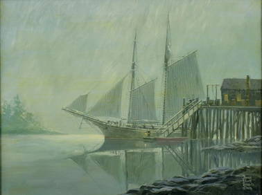
Bruce Elliot Roberts (NY,FL,1917-1993) oil paintingBroward Auction Gallery4.7(292)See Sold PriceMar 10, 2024
(2) 1973 First Coinage of the British Virgin Islands Proof SetsDana J. Tharp Auctions4.7(271)See Sold PriceFeb 24, 2024
(2) 1974 First Coinage of the Brisith Virgin Island Proof SetsDana J. Tharp Auctions4.7(271)See Sold PriceFeb 24, 2024
Vintage Framed Pine Island & Lacoste Island MapThe Benefit Shop Foundation Inc.4.3(2.9k)See Sold PriceMar 06, 2024
Virgin Islands print by L. Gluck matted and framedBaker's Antiques and Auctions3.2(471)See Sold PriceFeb 24, 2024
1764 Bellin Map of Lesser Antilles Northern Portion -- Petites Antilles ou Isles du Vent 3e. Partie.Jasper524.5(9.9k)See Sold PriceFeb 27, 2024
A23 United States in the Caribbean Denoyer-Geppert Social Science MapsJasper524.5(9.9k)See Sold PriceFeb 27, 2024
1975 British Virgin Islands Proof Gold 100 DollarsPacific Global Auction3.9(280)See Sold PriceFeb 26, 2024
2020 5 oz Silver ATB Salt River Bay, U.S. Virgin Islands3 Kings Auction4.3(201)See Sold PriceFeb 24, 2024
2020 5 oz Silver ATB Salt River Bay, U.S. Virgin IslandsGolden Air Auctions4.4(265)See Sold PriceFeb 24, 2024
1973 British Virgin Islands 6-Piece Proof Set (w/Box & COA)Golden Air Auctions4.4(265)See Sold PriceFeb 27, 2024
2017 British Virgin Islands 1 oz Silver Pegasus Reverse ProofGolden Air Auctions4.4(265)See Sold PriceFeb 25, 2024
1974 British Virgin Islands 6-Piece Proof Set (w/Box & COA)Golden Air Auctions4.4(265)See Sold PriceFeb 27, 2024
Virgin Islands print by L. Gluck matted and framedBaker's Antiques and Auctions3.2(471)See Sold PriceMar 03, 2024
2015 $1 British Virgin Islands 65th Anniversary of Peanuts Colorized ProofAndrew's Coin & Jewelry4.5(209)See Sold PriceMar 07, 2024
2009 United States Quarters District of Columbia and U.S. Territories Proof Set - 6 pc setKey Date Coins4.4(1.4k)See Sold PriceFeb 29, 2024
2009 United States Quarters District of Columbia and U.S. Territories Proof Set - 6 pc setKey Date Coins4.4(1.4k)See Sold PriceFeb 29, 2024
2009 United States Quarters District of Columbia and U.S. Territories Proof Set - 6 pc setKey Date Coins4.4(1.4k)See Sold PriceFeb 29, 2024