ATLAS of ANTIENT GEOGRAPHY by SAMUEL BUTLER 1843John McInnis Auctioneers,LLC4.6(502)See Sold PriceFeb 24, 2024
18TH C. ANTIQUE MAP: FRENCH & INDIAN WAR, FRAMEDThomaston Place Auction Galleries4.4(386)See Sold PriceFeb 24, 2024
Rand McNally Railroad Map Cabinet w/ 21 Railroad MapsRail & Road Auctions4.6(165)See Sold PriceMar 08, 2024
Keith Haring - Ink on New York Map, Best Buddies, Inscribed, Signed, and DatedSapphire Auction Gallery4(67)See Sold PriceMar 02, 2024
LATE 17TH C. FRENCH MAP OF THE NEW WORLD BY ALEXIS-HUBERT JAILLOT (1632-1712)Thomaston Place Auction Galleries4.4(386)See Sold PriceFeb 24, 2024
Central Railroad of New Jersey Map of Sandy Hook Route-ca. 1903JM Hobby Supply and Railroad Artifact Auctions4.4(126)See Sold PriceFeb 24, 2024
Lot of Six Mixed Atlas Box Cars-HO Scale-New in BoxJM Hobby Supply and Railroad Artifact Auctions4.4(126)See Sold PriceFeb 25, 2024
Rand McNally/Santa Fe Railroad Map of Iowa-1912JM Hobby Supply and Railroad Artifact Auctions4.4(126)See Sold PriceFeb 24, 2024
NICOLAES VISSCHER (NETHERLANDS, 1618-1709) MAP OF THE NEW WORLDThomaston Place Auction Galleries4.4(386)See Sold PriceFeb 24, 2024
17TH C. WORLD MAP BY NICOLAES VISSCHER (NETHERLANDS, 1618-1709)Thomaston Place Auction Galleries4.4(386)See Sold PriceFeb 24, 2024
Lot of Six Mixed Atlas Cabooses-HO Scale-New in BoxJM Hobby Supply and Railroad Artifact Auctions4.4(126)See Sold PriceFeb 25, 2024
U.S. Western centered Map, 1865Hawes, J.H. / Franks, Theodore. Map of the Public Land States And Territories. Lithographed map. GLO, 1865. 28 ¼" x 44 ¾" sheet. Map showing U.S. except for easternmost parts (from FL west). ShoSee Sold Price
1865 U.S. Map Of Territories & Pacific, Hand TintedDescription: Old Antique Map of the western United States titled; Territories & Pacific States to Accompany "Across the Continent" by Samuel Bowles. Engraved by J.H. Goldtwhait. Printed by G.W. & C.B.See Sold Price
Antique US Map of Territories & Pacific States, 1865Domestic: Free Shipping Item: Old Antique Map of the Western United States Title: Territories & Pacific States to Accompany "Across the Continent" by Samuel Bowles Engraver: J.H. Goldtwhait Printer: GSee Sold Price
SoldAntique US Map of Territories & Pacific States, 1865Domestic: Free ShippingItem: Old Antique Map of the Western United StatesTitle: Territories & Pacific States to Accompany "Across the Continent" by Samuel BowlesEngraver: J.H. GoldtwhaitPrinter: G.W.See Sold Price
Sold2 editions of Johnson's...Family Atlas, 1864 and[Atlases]. 2 editions of Johnson's...Family Atlas, text by Richard Fisher, NY, 1864 and 1865. All maps in color. 1864 edition has 7 US maps & 16 non-US maps. 1865 edition has 24 US maps & 32 non-US. ESee Sold Price
Sold1897 Western U.S. Map CollectionThis is a collection of four Western U.S. maps. Included are maps of North Dakota, Montana, Colorado and a combined map of Idaho and Wyoming with an inset of Yellowstone National Park. The maps are inSee Sold Price
Sold1869 Richardson Map of the Western US -- Map 1869 ofTitle/Content of Map: 1869 Richardson Map of the Western US -- Map 1869 of the Region Between the Mississippi and the Pacific, to Accompany Richardson's "Beyond the Mississippi". Date: 1869, HartfordCSee Sold Price
Sold2 Levasseur maps, Western U.S. and Pacific, 19th cTwo Victor Levasseur maps. Item 1: Steel engraved map of the world with colored borders titled "Planisphere" map by Victor Levasseur, engraved by Raimond Bonheur. Surrounded by an elaborate border witSee Sold Price
Sold3 maps: Western US, 2 Mexican War - related.[United States: West]. 3 Maps. ++ James H. Simpson and Edward M. Kern. Map Of The Route Pursued In 1849 By The U.S. Troops, Under the Command of Bvt. Lieut. Col. Jno. M. Washington, Governor [of] NewSee Sold Price
MAPS - Western US, Railroads. Rand McNallyWestern United States, Railroads. Rand McNally& Co., [Lot of 2] Map of the Chicago, Rock Island & Pacific Railway and Connections [and] Map Exhibiting the Leading Transportation Lines of the Pacific CSee Sold Price
MAP - Western US. U.S. Gov.Western United States. U.S. Gov., Workable Coal Lands, 1906 (dated). Printed Color. This mammoth map covers the entire western United States from the 97th meridian to the Pacific coast. The base map sSee Sold Price
1869 Richardson Map of the Western US -- Map 1869 ofTitle/Content of Map: 1869 Richardson Map of the Western US -- Map 1869 of the Region Between the Mississippi and the Pacific, to Accompany Richardson's "Bwyond the Mississippi". Date: 1869, HartfordSee Sold Price
1869 Richardson Map of the Western US -- Map 1869 ofTitle/Content of Map: 1869 Richardson Map of the Western US -- Map 1869 of the Region Between the Mississippi and the Pacific, to Accompany Richardson's "Bwyond the Mississippi". Date: 1869, HartfordSee Sold Price
SoldCivil War Map of Gen. Sherman's Marches, 1865Map: 1865 US War Dept. Civil War Map of Gen. Sherman's Marches -- Military Map Showing the Marches of the United States Forces Under the Command of Maj. Genl. W.T. Sherman U.S.A. during the Years 1863See Sold Price
SoldAnnals of San Francisco-1864With maps of San Francisco and Western U.S. (map is torn)See Sold Price
SoldFremont: Map of expedition to Rockies, 1845.[Western US]. Map Of An Exploring Expedition To The Rocky Mountains In the Year 1842; Oregon & North California in the Years 1843-44. J. C. Fremont, under orders of J. J. Abert. Lithographed in Balt:See Sold Price
SoldUSGS Mineral Resources of the US 86246Hardcover 1907 Part 1 Metallic producers. Large folding Western US map in back cover. 743pp with index. City: State: Date: 1907See Sold Price
SoldHenry Howe HISTORICAL COLLECTIONS OF THE GREAT WESTHenry Howe HISTORICAL COLLECTIONS OF THE GREAT WEST 1857 Decorative Leather Binding Gilt Marbled Page Edges Illustrated India-Tinted Engravings Maps Western US History Frontier Oregon New Mexico TexasSee Sold Price
Lot of 15 maps of the Western States, Texas, etc.655. [MAPS]. WESTERN U.S. & TEXAS. Lot of 15 maps of the Western States, Texas, etc. Nineteenth century. Very good to very fine. All matted, framed, and glazed. Includes: CSee Sold Price
SoldRARE PRE-CIVIL WAR "WESTERN" U.S. POCKET MAP"Ensign, Bridgman & Fanning's Traveller's Guide Through the Western States", published 156 William St. at Ann St, New York, 1856. In brown leather with gilt blindstamped title and decoration, having aSee Sold Price
Sold1854 Bartlett Map of Western US and Northern Mexico --Title/Content of Map: 1854 Bartlett Map of Western US and Northern Mexico -- Survey Map Showing the Countries Explored & Surveyed by the United States & Mexico Boundary Commission in the Years 1850, 5See Sold Price
SoldCary: US Western Territory/Great Lakes Region Map, 1805Map: A New Map of Part of the United States of North America, exhibiting the Western Territory, Kentucky, Pennsylvania, Maryland, Virginia &c., also the lakes Superior, Michigan, Huron, Ontario & ErieSee Sold Price
Sold1869 McNally Map of Western US -- Washington, Oregon,Title: 1869 McNally Map of Western US -- Washington, Oregon, Idaho, Nevada, Utah, and Arizona Date: 1869, New York Cartographer: F McNally Size: 10.8 X 8.5 in. Additional Information: This is a charmiSee Sold Price
SoldFrench Map of Western U.S. c.1870Heading: Author: Andriveau-Goujon Title: Etats-Unis (Etats l'Ouest) Place Published: [Paris] Publisher: Date Published: [c.1870] Description: Engraved map, hand-colored. 62See Sold Price
FLYING A TOURING SERVICE U.S. ROAD MAPS TIN WALL DISPLAY.Dan Morphy Auctions4.2(1.3k)See Sold PriceFeb 25, 2024
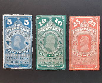
US 1865 Washington, Franklin and Lincon Newspaper, 5c 10c and 25cBazaar of Persia4.3(23)See Sold PriceFeb 24, 2024
Mel Crawford (CT,Canada,1925-2015) gouache paintingBroward Auction Gallery4.8(277)See Sold PriceMay 05, 2024
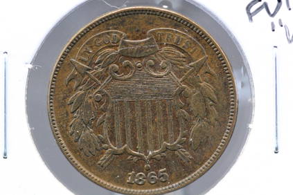
WOW 1865 US 2 Cent Piece. GORGEOUS. FULL "WE." SUPER High Grade. Civil War EraRichard L. Edwards Auctioneering4.8(2.3k)See Sold PriceFeb 27, 2024