ATLAS of ANTIENT GEOGRAPHY by SAMUEL BUTLER 1843John McInnis Auctioneers,LLC4.6(504)See Sold PriceFeb 24, 2024
18TH C. ANTIQUE MAP: FRENCH & INDIAN WAR, FRAMEDThomaston Place Auction Galleries4.4(389)See Sold PriceFeb 24, 2024
Rand McNally Railroad Map Cabinet w/ 21 Railroad MapsRail & Road Auctions4.6(165)See Sold PriceMar 08, 2024
Keith Haring - Ink on New York Map, Best Buddies, Inscribed, Signed, and DatedSapphire Auction Gallery4.1(67)See Sold PriceMar 02, 2024
LATE 17TH C. FRENCH MAP OF THE NEW WORLD BY ALEXIS-HUBERT JAILLOT (1632-1712)Thomaston Place Auction Galleries4.4(389)See Sold PriceFeb 24, 2024
Central Railroad of New Jersey Map of Sandy Hook Route-ca. 1903JM Hobby Supply and Railroad Artifact Auctions4.4(126)See Sold PriceFeb 24, 2024
Lot of Six Mixed Atlas Box Cars-HO Scale-New in BoxJM Hobby Supply and Railroad Artifact Auctions4.4(126)See Sold PriceFeb 25, 2024
Rand McNally/Santa Fe Railroad Map of Iowa-1912JM Hobby Supply and Railroad Artifact Auctions4.4(126)See Sold PriceFeb 24, 2024
NICOLAES VISSCHER (NETHERLANDS, 1618-1709) MAP OF THE NEW WORLDThomaston Place Auction Galleries4.4(389)See Sold PriceFeb 24, 2024
17TH C. WORLD MAP BY NICOLAES VISSCHER (NETHERLANDS, 1618-1709)Thomaston Place Auction Galleries4.4(389)See Sold PriceFeb 24, 2024
Lot of Six Mixed Atlas Cabooses-HO Scale-New in BoxJM Hobby Supply and Railroad Artifact Auctions4.4(126)See Sold PriceFeb 25, 2024
MAP - Western US. U.S. Gov.Western United States. U.S. Gov., Workable Coal Lands, 1906 (dated). Printed Color. This mammoth map covers the entire western United States from the 97th meridian to the Pacific coast. The base map sSee Sold Price
Sold5 Vols: Western US Surveys, signed MT Gov. Crosby[Western US History] 5 Vols. ++ PRELIMINARY REPORT CONCERNING EXPLORATIONS AND SURVEYS PRINCIPALLY IN NEVADA AND ARIZONA. Special Orders No. 109, War Department, March 18, 1871, and Letter of InstructSee Sold Price
MAP - Mid-Atlantic US. U.S. GovMid-Atlantic United States. U.S. Gov., Map of a Reconnaissance Between Baltimore and Philadelphia Exhibiting the Several Routes of the Mail-Road Contemplated by the Resolution of Congress Approved onSee Sold Price
Sold3 maps: Western US, 2 Mexican War - related.[United States: West]. 3 Maps. ++ James H. Simpson and Edward M. Kern. Map Of The Route Pursued In 1849 By The U.S. Troops, Under the Command of Bvt. Lieut. Col. Jno. M. Washington, Governor [of] NewSee Sold Price
Sold1854 Bartlett Map of Western US and Northern Mexico --Title/Content of Map: 1854 Bartlett Map of Western US and Northern Mexico -- Survey Map Showing the Countries Explored & Surveyed by the United States & Mexico Boundary Commission in the Years 1850, 5See Sold Price
Sold1869 McNally Map of Western US -- Washington, Oregon,Title: 1869 McNally Map of Western US -- Washington, Oregon, Idaho, Nevada, Utah, and Arizona Date: 1869, New York Cartographer: F McNally Size: 10.8 X 8.5 in. Additional Information: This is a charmiSee Sold Price
SoldMAPS - Maine. U.S. Gov.Maine. U.S. Gov., [Lot of 2] Map of the Northern Part of the State of Maine and of the Adjacent British Provinces... [and] Extract from a Map of the British and French Dominions in North America, 1838See Sold Price
Sold1869 Mitchell Map of Western US [verso] Mexico andTitle: 1869 Mitchell Map of Western US [verso] Mexico and Central America -- XIX California, Oregon, Idaho, Utah, Nevada, Arizona and Washington [verso] XX Mexico and Central America Cartographer: S MSee Sold Price
1854 Bartlett Map of Western US and Northern Mexico --Title/Content of Map: 1854 Bartlett Map of Western US and Northern Mexico -- Survey Map Showing the Countries Explored & Surveyed by the United States & Mexico Boundary Commission in the Years 1850, 5See Sold Price
1854 Bartlett Map of Western US and Northern MexicoTitle/Content of Map: 1854 Bartlett Map of Western US and Northern Mexico -- Survey Map Showing the Countries Explored & Surveyed by the United States & Mexico Boundary Commission in the Years 1850, 5See Sold Price
1869 McNally Map of Western US -- Washington, Oregon,Title: 1869 McNally Map of Western US -- Washington, Oregon, Idaho, Nevada, Utah, and Arizona Cartographer: F McNally Date: 1869, New York Size: 10.8 X 8.5 in. Additional Information: This is a charmiSee Sold Price
1856 Warren/Abbot Crossectional Map of Western US Surveys -- Profiles of the Main Routes Surveyed.Title: 1856 Warren/Abbot Crossectional Map of Western US Surveys -- Profiles of the Main Routes Surveyed. Compiled in 1855. By Lieutenants C. K. Warren & H. L. Abbot, Corps Top'l. Engineers CartographSee Sold Price
1861 Map of Western US -- Reduced Section of a General Map of North America, Drawn from the BestTitle: 1861 Map of Western US -- Reduced Section of a General Map of North America, Drawn from the Best Surveys 1795 to Accompany Winterbothams History Cartographer: US Government - Senate Year / PlacSee Sold Price
1869 Mitchell Map of Western US [verso] Mexico andTitle/Content of Map: 1869 Mitchell Map of Western US [verso] Mexico and Central America -- XIX California, Oregon, Idaho, Utah, Nevada, Arizona and Washington [verso] XX Mexico and Central America CaSee Sold Price
MAP - Mexico. U.S. GovMexico. U.S. Corps of Engineers, Plan of the Battle of Buena-Vista. Fought February 22nd and 23rd 1847., 1847 (dated). Black & White. Lithographic map drawn by Capt. Linnard and surveyed by LieutenantSee Sold Price
SoldMAPS, Mexico, U.S. GovernmentMexico, Mexican-American War. U.S. Gov., [Lot of 2] Plan of the Battle of Buena-Vista, Fought February 22nd and 23rd 1847 [and] Survey of the Mexican Lines of Defence at Cerro Gordo, and the Lines ofSee Sold Price
SoldMAPS, Western Europe, U.S. ArmyWestern Europe, World War II. U.S. Army, [Lot of 2] XIX Corps from D Day (6 June 1944) to Germany [and] XIX Corps in Action from Siegfried Line to Victory, 1944-45 (dated). Printed Color. These WorldSee Sold Price
Sold3 Booklets w/ maps: Geology, Western US, 1874-80.[Western US/Geology] 3 Titles. ++ Robert E. Strahorn. THE RESOURCES AND ATTRACTIONS OF IDAHO TERRITORY: Facts regarding climate, soil, minerals, agricultural and grazing lands, forests, scenery, gameSee Sold Price
SoldMAP - Western United States. U.S. War DeptWestern United States. U.S. War Department, Map of the Yellowstone and Missouri Rivers and Their Tributaries, 1867 (dated). Black & White. A large and very detailed map of the region explored by Capt.See Sold Price
SoldMAP - Michigan & Wisconsin. U.S. GovMichigan & Wisconsin. U.S. Gov., Map of That Part of the Mineral Lands Adjacent to Lake Superior, Ceded to the United States by the Treaty of 1842 with the Chippewas, 1845 (dated). Hand Color. The subSee Sold Price
Sold1897 Western U.S. Map CollectionThis is a collection of four Western U.S. maps. Included are maps of North Dakota, Montana, Colorado and a combined map of Idaho and Wyoming with an inset of Yellowstone National Park. The maps are inSee Sold Price
1838 US Gov Map Of Connecticut River & Saybrook Harbor1838 Us Government Map Of Connecticut River And Saybrook Harbor -- Map Of The Mouth Of The Connecticut River And Saybrook Harbour. Reduced From The Orginal Survey Of J.w. Adams. Made Under The DirectiSee Sold Price
Sold1869 Richardson Map of the Western US -- Map 1869 ofTitle/Content of Map: 1869 Richardson Map of the Western US -- Map 1869 of the Region Between the Mississippi and the Pacific, to Accompany Richardson's "Beyond the Mississippi". Date: 1869, HartfordCSee Sold Price
SoldMAP - Nebraska & South Dakota. U.S. Gov.Nebraska & South Dakota. U.S. Gov., Map Showing Positions of Nebraska State Troops in Indian Campaigns of the Winter of 1890-91, 1894 (circa). Black & White. This fascinating map has considerable histSee Sold Price
James McGinley (NJ,NY,MD,1937-2021) oil paintingBroward Auction Gallery4.8(285)See Sold PriceMar 10, 2024
James McGinley (NJ,NY,MD,1937-2021) oil paintingBroward Auction Gallery4.8(285)See Sold PriceMar 10, 2024
1885 CIVIL WAR 1ed Famous Memoirs US Grant Sheridan Sherman 6v RARE LOT MapsSchilb Antiquarian Rare Books4.8(422)See Sold PriceMar 10, 2024
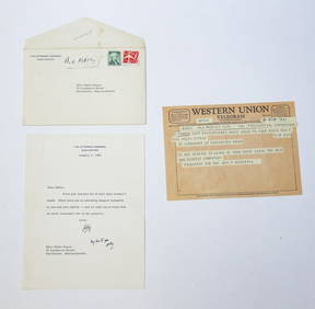
1963 J.F.K. & R.F.K. CONDOLENCES to MS. KEYESJohn McInnis Auctioneers,LLC4.6(504)See Sold PriceFeb 25, 2024
1963 J.F.K. for US PRESIDENT RE-ELECTION MATERIALJohn McInnis Auctioneers,LLC4.6(504)See Sold PriceFeb 25, 2024
Americo Makk (Hawaii,NY,Hungary,1927-2015) oil paintingBroward Auction Gallery4.8(285)See Sold PriceApr 14, 2024
Just Like Papa Western Cowboy and Son Bronze Bust Statue Sculpture 13" x 6"Weatherham Estate Treasures3.9(157)See Sold PriceMar 07, 2024
1994 Western Vogue Any Damn Place That Will Take Us Tour ShirtMynt Auctions4.6(689)See Sold PriceFeb 29, 2024
Original "Just Like Papa" Western Cowboy & Son Bronze Bust Sculpture - 10lbsWeatherham Estate Treasures3.9(157)See Sold PriceMar 14, 2024
Mel Crawford (CT,Canada,1925-2015) gouache paintingBroward Auction Gallery4.8(285)See Sold PriceMay 05, 2024
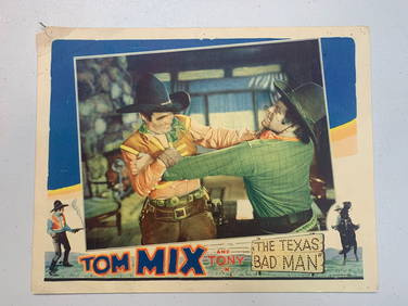
Western Lobby Card Bundle (x8) - Tom Mix & More (1930's) US Movie PostersJasper524.5(9.8k)See Sold PriceFeb 28, 2024
US Post Lewis And Clark First Day Stamp Sheet BundleRapid Estate Liquidators and Auction Gallery4.5(1.1k)See Sold PriceFeb 29, 2024


![1869 Mitchell Map of Western US [verso] Mexico and (1 of 2)](https://p1.liveauctioneers.com/5584/188299/94765046_1_x.jpg?height=282&quality=70&version=1608072723)


![1869 Mitchell Map of Western US [verso] Mexico and (1 of 2)](https://p1.liveauctioneers.com/5584/179019/90118111_1_x.jpg?height=282&quality=70&version=1600206230)