ATLAS of ANTIENT GEOGRAPHY by SAMUEL BUTLER 1843John McInnis Auctioneers,LLC4.5(505)See Sold PriceFeb 24, 2024
18TH C. ANTIQUE MAP: FRENCH & INDIAN WAR, FRAMEDThomaston Place Auction Galleries4.4(393)See Sold PriceFeb 24, 2024
Rand McNally Railroad Map Cabinet w/ 21 Railroad MapsRail & Road Auctions4.6(165)See Sold PriceMar 08, 2024
Keith Haring - Ink on New York Map, Best Buddies, Inscribed, Signed, and DatedSapphire Auction Gallery4(67)See Sold PriceMar 02, 2024
LATE 17TH C. FRENCH MAP OF THE NEW WORLD BY ALEXIS-HUBERT JAILLOT (1632-1712)Thomaston Place Auction Galleries4.4(393)See Sold PriceFeb 24, 2024
Central Railroad of New Jersey Map of Sandy Hook Route-ca. 1903JM Hobby Supply and Railroad Artifact Auctions4.4(127)See Sold PriceFeb 24, 2024
Lot of Six Mixed Atlas Box Cars-HO Scale-New in BoxJM Hobby Supply and Railroad Artifact Auctions4.4(127)See Sold PriceFeb 25, 2024
Rand McNally/Santa Fe Railroad Map of Iowa-1912JM Hobby Supply and Railroad Artifact Auctions4.4(127)See Sold PriceFeb 24, 2024
NICOLAES VISSCHER (NETHERLANDS, 1618-1709) MAP OF THE NEW WORLDThomaston Place Auction Galleries4.4(393)See Sold PriceFeb 24, 2024
17TH C. WORLD MAP BY NICOLAES VISSCHER (NETHERLANDS, 1618-1709)Thomaston Place Auction Galleries4.4(393)See Sold PriceFeb 24, 2024
Lot of Six Mixed Atlas Cabooses-HO Scale-New in BoxJM Hobby Supply and Railroad Artifact Auctions4.4(127)See Sold PriceFeb 25, 2024
SoldTWO MAPS: KANSAS/NEBRASKA 1855, ARIZONA/NEW MEXICO 1882J.H. Colton territories of Nebraska and Kanzas map dated 1855, with proposed routes for the Pacific Railroad, measures 23 x 26 inches overall. _x000D_ _x000D_ Also an 1882 map by S. August Mitchell ofSee Sold Price
SoldSurvey map of Arizona & New Mexico 1855Title: Route near the 32nd Parallel of North Latitude. Map No.2. From the Pimas Villages to Fort Fillmore Author: Parke, John G. Description: Lithographed map. 61x98 cm. (24x38½").Southern New MexicoSee Sold Price
SoldMaps of Navajo CountryHeading: (Arizona, New Mexico, Utah) Author: Gregory, Herbert E. Title: Two maps of the Navajo country, one of them hand-colored Place Published: Washington, D.C. Publisher: Date Published: 1See Sold Price
SoldColton's Map of California 1855Title: Colton's Map of California, Nevada, Utah, New Mexico, Colorado, Arizona & New Mexico Author: Colton, J.H. Description: Lithographed map, hand-colored. 38.2x62.2 cm. (15x24½") plus decorative bSee Sold Price
SoldJohnson's/Sharpe Corresponding Maps [Mexico]Two maps of Mexico / Guatemala, one J. Sharpe, Chapman & Hall map of Mexico & Guatemala, circa 1840's (exact date of map unverified). The other Johnson's Mexico circa 1860's (exact date of map unverifSee Sold Price
SoldMaps of Mexico & New MexidoHeading: (Mexico, etc.) Author: Title: Two maps of Mexico and adjacent areas Place Published: Paris & No place Publisher: Date Published: c.1780 & c.1845 Description: IncluSee Sold Price
Arizona & New Mexico 1903Title/Content of Map: Arizona & New Mexico 1903 Date Printed: 1903 Material/Medium: Paper Size: approx 10.5x13 inches Additional Info: The Crowell Publishing Co., Twentieth Century Peerless Atlas ReseSee Sold Price
Arizona & New Mexico 1903Title/Content of Map: Arizona & New Mexico 1903 Date Printed: 1903 Material/Medium: Paper Size: approx 10.5x13 inches Additional Info: The Crowell Publishing Co., Twentieth Century Peerless Atlas ReseSee Sold Price
Arizona & New Mexico 1903Title/Content of Map: Arizona & New Mexico 1903 Date Printed: 1903 Material/Medium: Paper Size: approx 10.5x13 inches Additional Info: The Crowell Publishing Co., Twentieth Century Peerless Atlas ReseSee Sold Price
SoldTwo Diderot Maps (California / Mexico) 1751-1780Two Diderot Maps (California & Northwest and Mexico) 1751 - 1780. Measure approximately 11 3/8" x 12.75 to 14" image sizes and 16" x 19" sheet sizes. Creased at fold lines. Unframed, loose and not gluSee Sold Price
SoldMitchell: Antique Map of Arizona & New Mexico, 1870Map: Arizona and New Mexico Cartographer: S. A. Mitchell Place & Date: Philadelphia / 1870 Size: 14 1/8" x 11 1/2" Condition: full color; light overall age toning The beautifully detailed and coloredSee Sold Price
Bradley: Antique Map of Arizona & New Mexico, 1886A fine example of William M. Bradley's 1886 map of Arizona and New Mexico. Shows just ten counties in Arizona Territory and thirteen in New Mexico Territory (plus Indian Reservation in upper left of sSee Sold Price
SoldEarly road map of Arizona & New MexicoHeading: (Arizona) Author: Title: Automobile Club of Arizona road map of principal routes between points in Arizona, Southern California and New Mexico Place Published: Phoenix Publisher: Date PSee Sold Price
SoldRare map of Sinaloa Mexico 1882Heading: Author: Weidner, Fredrich G. Title: Map of the State of Sinaloa, Mexico, from actual surveys and reconnoissances By Fredrick G. Weidner, Topographical & Mining Engineer Place Published: SanSee Sold Price
SoldColor geological maps of Arizona & New Mexico WheelerHeading: Author: Wheeler, George M. Title: Four color geological maps on three sheets, of Utah and some adjacent areas Place Published: Washington, D.C. Publisher: Date Published: 1873See Sold Price
SoldColor geological maps of Arizona & New Mexico WheelerHeading: Author: Wheeler, George M. Title: Three color geological maps of parts of Arizona and New Mexico Place Published: Washington, D.C. Publisher: Date Published: 1873 Description:See Sold Price
Color geological maps of Arizona & New Mexico WheelerHeading: Author: Wheeler, George M. Title: Three color geological maps of parts of Arizona and New Mexico Place Published: Washington, D.C. Publisher: Date Published: 1873 Description:See Sold Price
SoldMap of Kansas & Nebraska 1855Heading: (Kansas & Nebraska) Author: Colton, J[oseph] H[utchins] Title: Colton's Kansas and Nebraska Place Published: New York Publisher:J. H. Colton Date Published: 1855 Description: <See Sold Price
SoldGvastecan Reg."Title/Content of Map: Gvastecan Reg." Date: 1607 Cartographer: Abraham Ortelius (1527-1598) Size: 6.8X8.75 Lower half of a sheet of two maps. Shows northeastern Mexico with numerous Aztec and pre-ColuSee Sold Price
1882 Map of MexicoTitle: 1882 Map of Mexico Author: Blackie Medium: Ink on Paper Dimensions: 22"X15" Description: Map of Mexico dated 1882. Part of the Comprehensive Atlas & Geography of the World. Engraved by Edwin WeSee Sold Price
Caribbean & Mexico.- Ortelius (Abraham) Culiacanae,Caribbean & Mexico.- Ortelius (Abraham) Culiacanae, Americae Regionis Descriptio [on sheet with] Hispanoliae, Cubae, Aliarumque Insularum Circumiacientium, Delineato, two maps showing western Mexico aSee Sold Price
Caribbean & Mexico.- Ortelius (Abraham) Culiacanae,Caribbean & Mexico.- Ortelius (Abraham) Culiacanae, Americae Regionis Descriptio [on sheet with] Hispanoliae, Cubae, Aliarumque Insularum Circumiacientium, Delineato, two maps showing western Mexico aSee Sold Price
SoldCaribbean & Mexico.- Ortelius (Abraham) Culiacanae,Caribbean & Mexico.- Ortelius (Abraham) Culiacanae, Americae Regionis Descriptio [on sheet with] Hispanoliae, Cubae, Aliarumque Insularum Circumiacientium, Delineato, two maps showing western Mexico aSee Sold Price
1882 Map of MexicoTitle: 1882 Map of Mexico Author: Blackie Materials: Ink on Paper Dimensions: 22"X15" Description: Map of Mexico dated 1882. Part of the Comprehensive Atlas & Geography of the World. Engraved by EdwinSee Sold Price
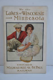
Chicago Milwaukee and St Paul RY To the Lakes of Wisconsin and Minnesota Book-1909JM Hobby Supply and Railroad Artifact Auctions4.4(127)See Sold PriceFeb 24, 2024
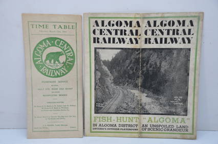
Algoma Central RY March 12, 1944 Public Timetable and BrochureJM Hobby Supply and Railroad Artifact Auctions4.4(127)See Sold PriceFeb 24, 2024
Great Western RY November 1, 1880 Public TimetableJM Hobby Supply and Railroad Artifact Auctions4.4(127)See Sold PriceFeb 24, 2024
Arthur Begay (AZ,NM,1932-2010) watercolor paintingBroward Auction Gallery4.7(292)See Sold PriceMar 31, 2024
Joseph Martin Kronheim Pair Early Color Glamor Prints c1850Luis Porretta Fine Arts4.3(10)See Sold PriceMar 02, 2024
1855 Map of New York & Erie Railroad and 1917 Trespassing On Railway Property Is A MisdemeanorRail & Road Auctions4.6(165)See Sold PriceMar 07, 2024
Willem Blaeu, Etc. 17th C. Antiquarian Maps, 2Auctions at Showplace4.6(740)See Sold PriceMar 17, 2024
William Simpson's Sketches at the Seat of War - Two Volumes with 81 Hand-colored LithographsTrillium Antique Prints & Rare Books4.5(32)See Sold PriceFeb 24, 2024
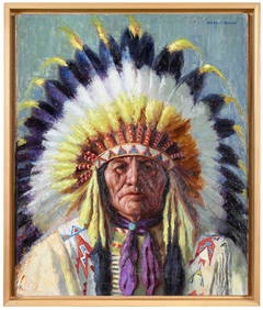
VARIOUS ARTISTS [SANTA FE RAILROAD / NATIVE AMERICANS]. Group of 5 posters. Circa 1950s.Swann Auction Galleries4.4(70)See Sold PriceFeb 29, 2024
Two Hand-Colored 19th Century Maps of New Orleans and Louisiana, Larger- H.- 12 1/2 in., W.- 15 1/2Crescent City Auction Gallery4.3(231)See Sold PriceMar 08, 2024
Blackie (Pub) 1882 Folio Map. World on Mercators ProjectionAlbion Auctions4.6(341)See Sold PriceMar 01, 2024
Jules de Liron d’Airoles (1802 - 1882) - Antique Fruit Print of Pond's Seedling PlumProverde Auctions4.3(3)See Sold PriceFeb 28, 2024
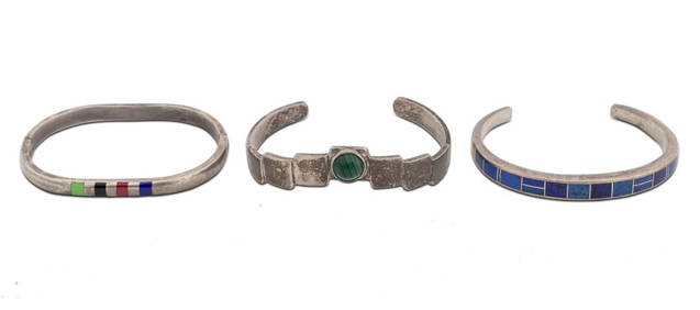
Native American, Etc. Sterling Silver Bracelets, 3Auctions at Showplace4.6(740)See Sold PriceFeb 13, 2025


![Johnson's/Sharpe Corresponding Maps [Mexico] (1 of 5)](https://p1.liveauctioneers.com/5755/162895/82236280_1_x.jpg?height=282&quality=70&version=1582932540)


![VARIOUS ARTISTS [SANTA FE RAILROAD / NATIVE AMERICANS]. Group of 5 posters. Circa 1950s. (1 of 1)](https://p1.liveauctioneers.com/199/319703/171640607_1_x.jpg?height=282&quality=70&version=1707943705)