SoldTwo 18th C. Framed Asian MapsFrom "A Geography of the World," London 1768. One depicting a map of China, the other depicting a map of Asia. Framed behind glass, 14.5" H x 15.5" W.See Sold Price
SoldTwo Framed 18th c. Maps Maryland - DelawareTWO framed 18th century maps of Maryland & Delaware 1) Maryland and Delaware together: "J. Denison" c. 1796 at 8" high by 10" wide inside matting.2) "State of Maryland by Samuel Lewis" measuring 11.5"See Sold Price
Sold6 FRAMED ITEMS, TWO 18TH C. MAPS, 12 1/4" X 161/4" OVERALL, WATERCOLOR SIGNED JOAN BRUMLEY, 17" X 21" OVERALL, EARLY ENGRAVING 14 1/4" 19" OVERALL, 2 HUNGARIAN FOLK DRAWERS, 11 1/2" X 14 1/2" OVERALL, BARTOK ESTATESee Sold Price
SoldILLUMINATIONS, ETC.Two, together with pastel on paper signed Augusta and a reproduction 17th/18th c. New York City map (all framed); Largest: 18 1/2" x 1 3/4" (irregular) (sheet)See Sold Price
SoldTwo 18th Century French Made European MapsTwo 18th century French made map prints, framed. "Carte Des Isles Britanniques" 23" x 30" map of the British Islands made in Paris by C.F. Delamarche, and 23" x 28 1/2" 1702 French West Coast map. SomSee Sold Price
SoldTwo Japanese ScrollsJapanese scroll, 18th / 19th c, signed and framed, 52"h x 20"w, together with another example of a bird of preySee Sold Price
SoldTwo 18th century engraved maps with hand coloringHind, Hindoostan, or India. Louis de la Rochette. Engraved map with hand color in part. London: W. Faden, c. 1790-1811. 31 x 23 inches framed. AND Africae in Tabula Geographica Delineatio. Adam FriedrSee Sold Price
SoldChinese 18th C. PaintingPainting, China, 18th century, of a landscape scene, ink and color on paper, will calligraphy at upper left, signed Wong Hu, marked with two seals, framed, 20" x 41" (image size).See Sold Price
SoldTwo framed Chinese scrolls depicting the ten BuddhistTwo framed Chinese scrolls depicting the ten Buddhist kings of hell, ink and colour on paper, 18thC, 94 x 176 cm (x2)See Sold Price
SoldTHREE CHINESE EXPORT BLUE AND WHITE DISHESThe first with a central scene showing two ladies and a child in a garden. The rim framed by a pomegranate themed border. With three flowering branches on the back side. 17-18th C. Dia. 26cm (10 1/4 iSee Sold Price
Sold(18th/ 19th c.) Chinese Silk EmbroideryAnimated exterior scene with man on dragon headed horseback between two youths, flowering tree and flowers. 18 x 14 inches. framed. Condition: Good, see photographsSee Sold Price
Sold18th/19th C Japanese Painting of Fudo Myoo18th/19th C Japanese Painting of Fudo Myoo with two acolytes, in ink and color on paper, now mounted to gold thread brocade borders and framed. Appears in good condition with light age related wear, bSee Sold Price
SoldTwo 18th C. Maps & Two 18th C. EngravingsLot consists of three 18th century engravings--1st item: Mid 18th century map titled "A New Map of Carolina by Robert Morden"; page taken from a book or publication "A Description of Carolina"; map siSee Sold Price
SoldTWO 18TH C. MAPS *NEW ENGLAND, NEW YORK, NEW JERSTWO 18TH C. MAPS *NEW ENGLAND, NEW YORK, NEW JERSEY, & PENSILVANIA (SIC) BY H. MOLL, GEOGRAPHER* AND NORTH AMERICA SIGNED NAME UNCERTAIN; 14 1/2 IN X 9 1/4 IN & NA IS 10 1/4 IN X 8 INSee Sold Price
SoldTwo 18th c. framed Delft tiles, 59"h x 6"w (11 in eachTwo 18th c. framed Delft tiles, 59"h x 6"w (11 in each frame)See Sold Price
SoldTwo 18th C Maps, G. M. CassiniBy Italian engraver, Giovanni Maria Cassini (1745-1824). 1. Map of Part of the Kingdom of Sardinia and Part of the Kingdom of Genoa: Rome, possibly c.1791. Copper engraved print, hand coloured. The thSee Sold Price
Sold18th C. Map of Australia w/Strait of Magellan18th c. framed map of Australia w/the Strait of Magellan. Copper engraved map, hand colored, w/ large colored pictorial cartouche, by Bernaidus Joannis Manasterienfis. Visible paper measures approximaSee Sold Price
SoldTwo 18th c Southeast Asian bronze figures ridingTwo of 18thc or early 19th c southeast Asian bronze figures riding elephants. 9" h and 8".See Sold Price
SoldTWO 18TH C. VT MAPS, J. SCOTT & J. WHITELAW.James Whitelaw 1794 engraved map of VT in an antique frame 21” x 17” overall, Joseph Scott 1795 State of Vermont in an antique frame 17” x 15” overall.See Sold Price
Sold4 Framed Maps, 18th C., Kitchin & JefferysFour 18th C. Small Framed Maps includes Sweden, Denmark, Norway, Finland, Spain and Portugal by Thomas Kitchin and Thomas Jefferys 7 1/2 x 8 1/2 , framed 16 x 17 1/2 CLAN7190/4 MMSee Sold Price
SoldBX 10 FRAMED ITEMS, 18th + 19th c. ENGR., FRAMED ASIANBX 10 FRAMED ITEMS, 18th + 19th c. ENGR., FRAMED ASIAN NEEDLEWORKSee Sold Price
SoldPair of Asian BatiksBATIKS. Lot of two 18th to 19th c. Asian rose motif batiks, signed. 14 1/2" x 21 1/2" viewed, one is faded, otherwise in good condition.See Sold Price
Sold18th C. Milan Ducatus Mediterranean Map18th C. framed copper engraved map, hand colored of Milan, Genoa, Lake Como and Mantua Cartouche. By Matthai Serteri, S.C.M. GEOGR Augustani. Visible paper measures approximately 20.25" H X 24" W, witSee Sold Price
SoldTwo Framed 18th C. German EndpapersA set of two handmade German endpapers circa 18th C., with foliate designs and gilt leaf. Framed under glass. Each mat opening: 12-3/4 in x 15-1/2 in.See Sold Price
EARLY WALL CLOCK WITH "EDMONDS LONDON" FUSEE MOVEMENTThomaston Place Auction Galleries4.4(386)See Sold PriceFeb 24, 2024
LATE 18TH C. VERY LARGE CHART OF NORTHEAST CANADA BY DES BARRES (1721-1824), 1780, FRAMEDThomaston Place Auction Galleries4.4(386)See Sold PriceFeb 24, 2024
EARLY 18TH C. DUTCH CHART OF PACIFIC OCEAN BY FREDERIK DE WIT (1629-1706) WITH CALIFORNIA AS ANThomaston Place Auction Galleries4.4(386)See Sold PriceFeb 24, 2024
LARGE EARLY 18TH C. DUTCH CHART OF UPPER NORTH AMERICA, PIERRE MORTIER (1661-1711), FRAMEDThomaston Place Auction Galleries4.4(386)See Sold PriceFeb 24, 2024
17TH C. ANTIQUE MAP SIEGE OF LA ROCHELLE, FRANCE, FRAMEDThomaston Place Auction Galleries4.4(386)See Sold PriceFeb 24, 2024
EARLY 18TH C. MAP OF ITALY, FRAMEDThomaston Place Auction Galleries4.4(386)See Sold PriceFeb 24, 2024
LATE 16TH C. MAP OF SCOTLAND BY MERCATOR, FRAMEDThomaston Place Auction Galleries4.4(386)See Sold PriceFeb 24, 2024
17TH C. MAP OF THE BERKSHIRES BY JOHN SPEED, FRAMEDThomaston Place Auction Galleries4.4(386)See Sold PriceFeb 24, 2024
18TH C. ANTIQUE MAP: FRENCH & INDIAN WAR, FRAMEDThomaston Place Auction Galleries4.4(386)See Sold PriceFeb 24, 2024
17TH C. ENGLISH LINEAR MAP BY OGILBY, FRAMEDThomaston Place Auction Galleries4.4(386)See Sold PriceFeb 24, 2024
Two (2) Antique 18th C. Copper Engraved Framed Maps - America & EuropeMagnusson Art Group4.5(46)See Sold PriceMar 14, 2024
Late 18th century map of England and Wales sampler and two printsFellows4.3(159)See Sold PriceMar 05, 2024
THE WHOLE CHRONICLE OF POLYBIUS ANCIENT IN ENGLISH, 1756NY Elizabeth 4.3(84)See Sold PriceMar 03, 2024
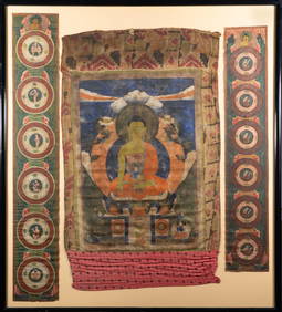
Large Antique 19th c. Framed Tibetan Thangka of Buddha in Landscape with PanelsMagnusson Art Group4.5(46)See Sold PriceMar 14, 2024
TWO 18TH C. PORTSMOUTH NH CHIPPENDALE SIDE CHAIRS.William Smith Auctions4.6(146)See Sold PriceMar 06, 2024
TWO 18th C CHINESE EXPORT PAINTINGS OF MUSICIANSA.H. Wilkens Auctions & Appraisals4.7(388)See Sold PriceFeb 29, 2024
CHINESE YELLOW PEKING GLASS SNUFF BOTTLE 18-19TH CNoble House Collection Gallery4.5(114)See Sold PriceMar 10, 2024
A Famille Rose Hanging Plaque, 18thCStunning Arts Auction & Appraisal 4.6(75)See Sold PriceMar 09, 2024
A Famille Rose Plate Inlaid Wood Ornament, 18thCStunning Arts Auction & Appraisal 4.6(75)See Sold PriceMar 09, 2024