SoldTopography & Bathymetry Map; The Great Lakes3-D topographic and bathymetry nautical wood chart of The Great Lakes. It features information on each lake and map surrounding area. This laser cut masterpiece is presented in an oak shadow box withSee Sold Price
Sold1875 US Coast Survey Map Great Lakes"Progress Chart of the Survey of the Northern & North Western Lakes July 1st 1875. Primary Triangulation, Telegraphic Longitudes, Shore Line, Topography and Hydrography." Engraved in the Office of theSee Sold Price
Soldc. 1755 Handcolored Map: Great Lakes and CanadaHistoric Maps c. 1755 Handcolored Map of The Great Lakes and Canada c. 1755 (1755-Dated) French and Indian War Era, Hand-colored, Copper Plate-engraved, Map, Primarily of North America Great Lakes RegSee Sold Price
Soldc. 1755 Handcolored Map: Great Lakes and CanadaHistoric Maps c. 1755 Handcolored Map of The Great Lakes and Canada c. 1755 (1755-Dated) French and Indian War Era, Hand-colored, Copper Plate-engraved, Map, Primarily of North America Great Lakes RegSee Sold Price
Great Lakes railroad systems. Wisconsin Central. SooTITLE/CONTENT OF MAP: '[Great Lakes railroad systems]. Wisconsin Central. Minneapolis St Paul & Sault Ste Marie. Canadian Pacific. Duluth South Shore Atlantic. Wabash' DATE: Unknown but estimated at cSee Sold Price
Soldd'Anville / Santini: Antique Map of Great Lakes, 1775Map: Partie Occidentale du Canada et Septentrionale de la Louisiane Cartographer: d'Anville / Santini Place & Date: Venice / 1775 Size: 22 1/4" x 19" Condition: outline color; light overall age toningSee Sold Price
Bellin: Map of Great Lakes, 1755Map: 1755 Bellin Map of Great Lakes -- Partie Occidentale de la Nouvelle France… Cartographer: J N Bellin, Homann issue Year / Place: 1755, Nurnberg Map Dimensions: 24 x 19 in. This is iconic and suSee Sold Price
Sold1749 Robert de Vaugondy Map of Great Lakes Region --Title/Content of Map: 1749 Robert de Vaugondy Map of Great Lakes Region -- Les Lacs du Canada et Nouvelle Angleterre Date: 1749, Paris Cartographer: G Robert de Vaugondy Size: 6.5 X 8,5 in. This is anSee Sold Price
Santini / d'Anville: Antique Map of Great Lakes, 1784Partie Occidentale du Canada et Septentrionale de la Louisiane avec une Partie de la Pensilvanie par le Sr. d'Anville de l'Academie Rle. des Inscriptions et Belles-Lettres et de celle des Sciences deSee Sold Price
SoldJ. N. Bellin Map of Great LakesJacques-Nicolas Bellin, French, 1703-1772. Engraved map entitled "Carte des Cinq Grands Lacs du Canada". Not examined out of the frame. Creasing evident. Image is 14" x 9" high, in a contemporary woodSee Sold Price
SoldInfluential map of Great Lakes region 1755Heading: Author: Bellin, Jacques Nicolas Title: Partie Occidentale de la Nouvelle France ou du Canada Place Published: Nuremberg Publisher:Homann Heirs Date Published: 1755 DescriptionSee Sold Price
SoldScarce 1876 twp. map of Great LakesUnusual and very scarce hand colored map from the scarce Jones & Hamilton Historical Atlas of the World Illustrated. Published in 1876 by H. H. Hardesty, this “Special Map” delineates every townshSee Sold Price
1783 Delisle/Dezauche Map of Great Lakes and Canada --Title: 1783 Delisle/Dezauche Map of Great Lakes and Canada -- Carte du Canada qui Comprend la Partie Septentrionale des Etars Unis d'Amerique… Cartographer: Delisle/Dezauche Year / Place: 1783, PariSee Sold Price
SoldFrench framed Map The Great LakesFrench framed Map titlted "The Great Lakes" by Guillaum DeLule 1720, 19 1/2" x 17 1/4"See Sold Price
d'Anville: Antique Map of Great Lakes Midwest, 1784TITLE/CONTENT OF MAP: 'Partie Occidentale du Canada et Septentrionale de la Louisiane avec une Partie de la Pensilvanie par le Sr. d'Anville de l'Academie Rle. des Inscriptions et Belles-Lettres et deSee Sold Price
SoldMap of Great Lakes region 1812Title: The Northwestern Territories of the United States Author: Brookes, Richard Description: Copper-engraved map. 19.5x24.5 cm. (7¾x9¾"). The Great Lakes region, mostly Michigan Territory and areaSee Sold Price
1700 Sanson Map of Great Lakes and American East Coast -- Le Canada, ou Nouvelle France, &c. TireeTitle: 1700 Sanson Map of Great Lakes and American East Coast -- Le Canada, ou Nouvelle France, &c. Tiree de Diverses Relations des Francois, Anglois, Hollandois, &c. Cartographer: N Sanson Year / PlaSee Sold Price
SoldNATIONAL GEOGRAPHIC MAP 1953 GREAT LAKES REGIONNATIONAL GEOGRAPHIC MAP 1953 GREAT LAKES REGION - Measures 26 1/2" by 40 1/2". Worn. See photos. Dated Dec 1953. - ****PLEASE NOTE ***** 1) The Ending Time posted for this item is wrong. Ebay will disSee Sold Price
Bonne Map of Great Lakes & Western CanadaTitle: Partie Occidentale du Canada, contenant les cinq Grand Lacs, avec les Pays Circonvoisins Author: Bonne, Rigobert Description: Copper-engraved map. 20.6x31.2 cm. (8½x12½").From Lake Ontario weSee Sold Price
1783 Delisle/Dezauche Map of Great Lakes and Canada --Title: 1783 Delisle/Dezauche Map of Great Lakes and Canada -- Carte du Canada qui Comprend la Partie Septentrionale des Etars Unis d'Amerique… Cartographer: Delisle/Dezauche Year/Place: 1783, PaSee Sold Price
SoldBonne Map of Great Lakes & Western CanadaTitle: Partie Occidentale du Canada, contenant les cinq Grand Lacs, avec les Pays Circonvoisins Author: Bonne, Rigobert Description: Copper-engraved map, modern hand-coloring. 20.6x31.2 cm. (8½x12½"See Sold Price
MAPS - Canada & Great Lakes. HildburghausenEastern Canada, Great Lakes. Hildburghausen Biblio Institut, [Lot of 2] Ober- (Upper-) Canada [and] Neueste Karte von Lower Canada. (Unter-Canada)..., 1844-45 (dated). Hand Color. This pair of maps foSee Sold Price
SoldBellin: Antique Map of the Great Lakes, 1755Map: 1755 Bellin Map of Great Lakes -- Partie Occidentale de la Nouvelle France… Cartographer: J N Bellin, Homann issue Year / Place: 1755, Nurnberg Map Dimensions: 24 x 19 in. Condition: Very goodSee Sold Price
SoldEdison Sault Electric CompanyMI 1950-1980's. Specimen. 4 different certificates. All have vignette of map of great lakes with railroad routes noted and cornucopias on either side. 1). < than 100 shs, orange. 2). 100 shs, brown. 3See Sold Price
Rand McNally Railroad Map of Arizona-1909JM Hobby Supply and Railroad Artifact Auctions4.4(126)See Sold PriceFeb 24, 2024
Rand McNally Railroad Map of Washington-1906JM Hobby Supply and Railroad Artifact Auctions4.4(126)See Sold PriceFeb 24, 2024
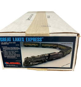
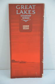
Canadian Pacific RY Great Lakes Steamship 1919 Brochure and TimetableJM Hobby Supply and Railroad Artifact Auctions4.4(126)See Sold PriceFeb 24, 2024
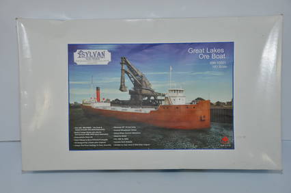
Sylvan Models Great Lakes Ore Boat Kit-HO Scale-New in BoxJM Hobby Supply and Railroad Artifact Auctions4.4(126)See Sold PriceFeb 25, 2024
LARGE LATE 17TH C. DUTCH CHART OF CANADA, GREAT LAKES, NEW FRANCE, LABRADOR, HUDSON BAY, BY PIERREThomaston Place Auction Galleries4.4(386)See Sold PriceFeb 24, 2024
LATE 17TH C. FRENCH MAP OF THE NEW WORLD BY ALEXIS-HUBERT JAILLOT (1632-1712)Thomaston Place Auction Galleries4.4(386)See Sold PriceFeb 24, 2024
(3 Ohio Pennants Great Lakes Expo, Put in Bay, '56 Blue holeDana J. Tharp Auctions4.7(268)See Sold PriceFeb 24, 2024
1936 Great Lakes Exposition Cleveland Centennial Ashtray and TicketDana J. Tharp Auctions4.7(268)See Sold PriceFeb 24, 2024
GREAT LAKES INDIANS: A Pictorial Guide 1970 Folio Size BookNorth American Artifact Auctions4.6(182)See Sold PriceApr 20, 2024
[MAP]. [ALBRIZZI, Giambatista, 1698-1777]. Carta Geografica...Potter & Potter Auctions4.6(539)See Sold PriceMar 07, 2024
1940s WWII Great Lakes IL US Naval Training Station Happy Hour PostcardMynt Auctions4.6(680)See Sold PriceFeb 26, 2024
4 1/2" Clay Pipe. Great Lakes Area. Ex Len Murphy. Bennett COATony Putty Artifacts4.7(404)See Sold PriceMar 09, 2024
Book: Where Two Worlds Meet, The Great Lakes Fur Trade By Carolyn GilmanTony Putty Artifacts4.7(404)See Sold PriceMar 09, 2024
1764 Bellin Map of St. Kitts -- Carte de l'Isle St. ChristopheJasper524.5(9.8k)See Sold PriceFeb 27, 2024
Monmouth, Illinois Vintage Topography MapRapid Estate Liquidators and Auction Gallery4.5(1.1k)See Sold PriceFeb 28, 2024


![[MAP]. [ALBRIZZI, Giambatista, 1698-1777]. Carta Geografica... (1 of 1)](https://p1.liveauctioneers.com/928/318880/171361280_1_x.jpg?height=282&quality=70&version=1707501302)