ATLAS of ANTIENT GEOGRAPHY by SAMUEL BUTLER 1843John McInnis Auctioneers,LLC4.5(505)See Sold PriceFeb 24, 2024
18TH C. ANTIQUE MAP: FRENCH & INDIAN WAR, FRAMEDThomaston Place Auction Galleries4.4(393)See Sold PriceFeb 24, 2024
Rand McNally Railroad Map Cabinet w/ 21 Railroad MapsRail & Road Auctions4.6(165)See Sold PriceMar 08, 2024
Keith Haring - Ink on New York Map, Best Buddies, Inscribed, Signed, and DatedSapphire Auction Gallery4.1(67)See Sold PriceMar 02, 2024
LATE 17TH C. FRENCH MAP OF THE NEW WORLD BY ALEXIS-HUBERT JAILLOT (1632-1712)Thomaston Place Auction Galleries4.4(393)See Sold PriceFeb 24, 2024
Central Railroad of New Jersey Map of Sandy Hook Route-ca. 1903JM Hobby Supply and Railroad Artifact Auctions4.4(127)See Sold PriceFeb 24, 2024
Lot of Six Mixed Atlas Box Cars-HO Scale-New in BoxJM Hobby Supply and Railroad Artifact Auctions4.4(127)See Sold PriceFeb 25, 2024
Rand McNally/Santa Fe Railroad Map of Iowa-1912JM Hobby Supply and Railroad Artifact Auctions4.4(127)See Sold PriceFeb 24, 2024
NICOLAES VISSCHER (NETHERLANDS, 1618-1709) MAP OF THE NEW WORLDThomaston Place Auction Galleries4.4(393)See Sold PriceFeb 24, 2024
17TH C. WORLD MAP BY NICOLAES VISSCHER (NETHERLANDS, 1618-1709)Thomaston Place Auction Galleries4.4(393)See Sold PriceFeb 24, 2024
Lot of Six Mixed Atlas Cabooses-HO Scale-New in BoxJM Hobby Supply and Railroad Artifact Auctions4.4(127)See Sold PriceFeb 25, 2024
Topographical Map of Part of the Selkirk Range BritishMap: Topographical Map of Part of the Selkirk Range British Columbia Date: 1906 Cartographer: WHEELER, ARTHUR O./H.G. WHEELER; M.P. BRIDGLAND Publisher: DEPT. OF THE INTERIOR. CANADA Size (inches): 44See Sold Price
BRITISH COLUMBIA: Part of the Selkirk Range. Rev. GreenTITLE/CONTENT OF MAP: 'Part of the Selkirk Range British Columbia; Inset map of The Southern Part of British Columbia' DATE PRINTED: 1889 IMAGE SIZE: Approx 38.5 x 27.5cm, 15 x 10.75 inches (Large); PSee Sold Price
Antique Topographical Map of the Rocky MountainsTitle/Content of Map: Topographical Map of Part of the Main Range Of the Rocky Mountains Publication Date: 1903-1907 ca. Authors: TOPOGRAPHICAL SURVEYS BRANCH, DEPARTMENT OF THE INTERIOR CANADA, WHEELSee Sold Price
SoldKootenay District of British Columbia, CanadaHeading: (Canada) Author: Title: Topographical map of part of West Kootenay District Place Published: [Canada] Publisher: Province of British Columbia, Lands and Works Dept. Date Published:See Sold Price
SoldA Topographical Map of the North Part of New YorkWilliam Faden (1750 - 1836). London: Faden, 1793. 19 3/4 x 13 inches. This map records activity in 1776 when the British, led by General Howe, attacked New York City, defended by General Washington. DSee Sold Price
Faden Map of the North Part of New York IslandFADEN, William (1749 - 1836). A Topographical map of the North Part of New York Island, exhibiting the Plan of Fort Washington, now Fort Knyphausen. Engraved map. London, April 12, 1793 from Steadman'See Sold Price
Laurent: Topographical Plan of Manchester England, 1793Map: 1793 Laurent Map of Manchester England -- A Topographical plan of Manchester and Salford with the adjacent parts; shewing also the different allotments of land proposed to be built on as communicSee Sold Price
Sold(Maps and Charts, North America), Pownall, Thomas(Maps and Charts, North America), Pownall, Thomas (1722-1805), A Topographical Description of Such Parts of North America as are contained in the (Annexed) Map of the Middle British Colonies in NorthSee Sold Price
Thomas Pownall, A Topographical Description of SuchPOWNALL, Thomas (1722-1805). A Topographical Description of Such Parts of North America as are Contained in the (Annexed) Map of the Middle British Colonies, &c in North America. London: Printed for JSee Sold Price
British India, Southern partEngraved for Thomson’s New General Atlas, London, 1815 50.5 cm 59.5 cm Geometric gray-lined octagonal cartouche. Original color (provinces); shaded mountain ranges. Much detail of interior, incSee Sold Price
SoldAntique topographical map, Tjietjerkstra part, printedAntique topographical map, Tjietjerkstra part, printed in the 18th century, 45x43 cmSee Sold Price
A Topographical Map of Parts of Eastern California andA U.S. Geographical Survey Military Issued Topographical Map of Parts of Eastern California and Western Nevada extending from Lake Tahoe, Reno, Carson, Astor Pass, Honey Lake, Horse Lake, Pyramid LakSee Sold Price
SoldMap of Gulf Coast, 1861, by Pessou & Simon, N.O."Hydrographical & Topographical Map of Parts of the States of Louisiana, Mississippi & Alabama, Compiled from the U.S. Coast Surveys", 1861, by William H. Wilder, published by Messrs. Holle & Co., ExcSee Sold Price
SoldU.S. G.S. Guide Books of the Western U.S. (withU.S.G. S. United States Geological Survey Guide Books of the Western U.S.) (With Geologic & Topographical Maps) 1) Part D - The Shasta Route & Coast Line Bulletin No.614, published 1915 ( 6 x9 HardbacSee Sold Price
SoldRare map of Colorado Mining Distrucet 1880Heading: Author: Nell, Louis Title: Topographical & Township Map of Part of the State of Colorado Exhibiting the San Juan, Gunnison and California Mining Regions. Compiled from U.S. Government SurveySee Sold Price
SoldA Topographical Map of the Northn. Part of New YorA Topographical Map of the Northn. Part of New York Island, 1777 Faden, William. A Topographical Map of the Northn. Part of New York Island, Exhibiting the Plan of Fort Washington, now Fort KnyphausSee Sold Price
SoldA Topographical Map of the North Part of New YorkA Topographical Map of the North Part of New York Island, 1777 Faden, William. A Topographical Map of the Northn. Part of New York Island, Exhibiting the Plan of Fort Washington, now Fort KnyphausenSee Sold Price
A Rare Topographical Land Classification Map of PartsA Rare and Original Military Issued Topographical Land Classification Map of Parts of Eastern California and Western Nevada extending from Lake Tahoe, Reno, Carson, Astor Pass, Honey Lake, Horse Lake,See Sold Price
SoldTRAVIS KEESE (American/Texas b. 1932) A PAINTING, "HighTRAVIS KEESE (American/Texas b. 1932) A PAINTING, "High Solitude, Stone Rams, Hermit Range, Selkirk Mts., British Columbia, CA.," oil on canvas, signed L/R, verso titled, placed and a paper gallery laSee Sold Price
SoldClaude Joseph Sauthier (1736-1802) William FadenClaude Joseph Sauthier (1736-1802) William Faden (1750-1836) hand colored engraved topographical map of the north part of New York Island exhibiting the plan of Fort Washington now Fort Knyphausen wiSee Sold Price
SoldFaden. New York Island. 1777[American Revolutionary War]. Claude Joseph Sauthier. A Topographical Map Of The Northn. Part Of New York Island, Exhibiting the Plan of Fort Washington, now Fort Knyphausen, With the Rebels Lines toSee Sold Price
Teesdale New Chart of the WorldHenry Teesdale (Publisher) and John Dover (Engraver) A New Chart of the World on Mercator's Projection... Hand-colored Engraving London, 1845 Framed: 45 1/2" x 58" This large-scale British two-part maSee Sold Price
SoldWILLIAM FADEN (English, 1750-1836)WILLIAM FADEN (English, 1750-1836); ''Topographical Map of the North Part of New York Island Exhibiting the Plan of Fort Washington, now Fort Knyphausen, with the Rebels Lines to the Southward...'', pSee Sold Price
SoldThomson: Antique Map of British India, 1814Map: British India Southern Part/British India Northern Part Cartographer: Thomson Place & Date: Edinburgh / 1814/1817 Size: 24 1/8" x 22 5/8" Condition: overall age-toning and spotting; repaired spliSee Sold Price
18TH C. ANTIQUE MAP: FRENCH & INDIAN WAR, FRAMEDThomaston Place Auction Galleries4.4(393)See Sold PriceFeb 24, 2024
Jerusalem Map for British Soldiers in Palestine - WW2Levy Auction House4.3(11)See Sold PriceFeb 27, 2024
Souvenir Silver Ring - The Conquest of Jerusalem, 1917Levy Auction House4.3(11)See Sold PriceFeb 27, 2024
Group of 15 Printed or Lithographed Items, including: litho...Potter & Potter Auctions4.6(545)See Sold PriceMar 07, 2024
[CHICAGO]. Rare Pre-Fire Illinois Map: “Blanchard’s Map of ...Potter & Potter Auctions4.6(545)See Sold PriceMar 07, 2024
D'Oyly (Calcutta, India) - Government House from St. Andrew's LibraryTrillium Antique Prints & Rare Books4.5(32)See Sold PriceFeb 24, 2024
D'Oyly (Calcutta, India) - Procession of the CurruckpoojaTrillium Antique Prints & Rare Books4.5(32)See Sold PriceFeb 24, 2024
Map of Part of the West Indies, Etc., Showing the Exact Position Of The U.S. War Steamer SanJasper524.5(9.9k)See Sold PriceFeb 27, 2024
Emory's Notes of a Military Reconnoissance larger issuePBA Galleries4.7(385)See Sold PriceMar 07, 2024
Pre-colonial Africa. Mountains of Kong/Moon. Caravan routes. THOMSON 1817 mapJasper524.5(9.9k)See Sold PriceFeb 28, 2024
CENTRAL AFRICA. Tanzania, Kenya, Angola, Zambia, Congo, Mozambique 1903 mapJasper524.5(9.9k)See Sold PriceFeb 28, 2024
PRE COLONIAL WESTERN AFRICA. Shows Mountains of Kong. Tribes. WELLER 1863 mapJasper524.5(9.9k)See Sold PriceFeb 28, 2024
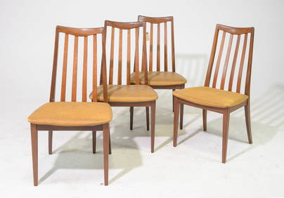
4 High Back Mid Century Dining Chairs - G-Plan FrescoGallery Auctions4.8(302)See Sold PriceFeb 27, 2024
Lot of 19 Military Prints - Swedish & British Arme Uniform - Schwerin leading battle - JuliusProverde Auctions4.3(3)See Sold PriceFeb 28, 2024
Henry Seebohm (1832 - 1895) - Set of 2 British Bird Egg Prints - Pink Footed Goose - Brent Goose -Proverde Auctions4.3(3)See Sold PriceFeb 28, 2024
Herman Moll A New Map of Ye North Parts of AmericaWillow Auction House4.5(289)See Sold PriceMar 14, 2024


![[CHICAGO]. Rare Pre-Fire Illinois Map: “Blanchard’s Map of ... (1 of 2)](https://p1.liveauctioneers.com/928/318880/171361260_1_x.jpg?height=282&quality=70&version=1707501302)